Bridge Statistics for Center Point, Indiana (IN)
Condition, Traffic, Stress, Structural Evaluation, Project Costs
- National Bridge Inventory (NBI) Statistics
- 38Number of bridges
- 325ft / 99.1mTotal length
- $2,014,000Total costs
- 275,136Total average daily traffic
- 61,535Total average daily truck traffic
- National Bridge Inventory (NBI) Registered Bridges for Center Point
- No street view available for this location
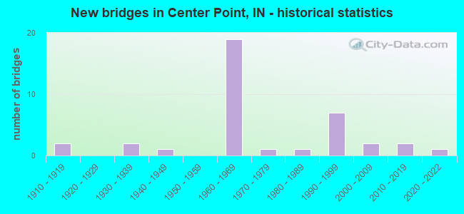
- New bridges - historical statistics
- 21910-1919
- 21930-1939
- 11940-1949
- 191960-1969
- 11970-1979
- 11980-1989
- 71990-1999
- 22000-2009
- 22010-2019
- 12020-2022

- Reconstructed bridges - Historical Statistics
- 11970-1979
- 61980-1989
- 11990-1999
- 12000-2009
- 22010-2019


- Bridge Condition - Deck
- 7.1%Very good
- 32.1%Good
- 35.7%Satisfactory
- 25.0%Fair

- Bridge Condition - Superstructure
- 3.4%Excellent
- 3.4%Very good
- 41.4%Good
- 27.6%Satisfactory
- 20.7%Fair
- 3.4%Poor

- Bridge Condition - Substructure
- 13.8%Very good
- 44.8%Good
- 24.1%Satisfactory
- 17.2%Fair

- Bridge Condition - Channel
- 7.7%Excellent
- 26.9%Very good
- 34.6%Good
- 15.4%Satisfactory
- 7.7%Fair
- 7.7%Poor
Find on map >> Show street view
Structure Number: 1577, Location: 00.96 E SR 59 (Lat: 39.445711, Lng: -87.108361), Route carried "on" structure: State highway 42, Year Built: 1942, Year Reconstructed: 1985, Status: Open, Structure Length: 2.62m (8.60ft), Average Daily Traffic: 1,770 (year 2006), Truck Traffic: 4%, Average Future Daily Traffic: 2,938 (year 2030), Design Load: HS 20, Features Intersected: BIRCH CREEK
Minimum Vertical Clearance: 30+ m (98+ ft), Kilometerpoint: 11.217, Lanes on structure: 2, Owner: State Highway Agency, Approaching Roadway Width: 12.8m (42.0ft), Material/Design: Prestressed concrete, Design/Construction: Stringer/Multi-beam, Number Of Spans In Main Unit: 1, Length of Maximum Span: 25.8m (84.6ft), Curb-To-Curb Width: 12.8m (42.0ft), Out-to-Out Width: 13.6m (44.6ft)
Condition: Deck: Satisfactory, Superstructure: Satisfactory, Substructure: Satisfactory, Channel: Very good, Operating Rating: 54.1 metric tons, Method Used To Determine Operating Rating: Load and Resistance Factor Rating (LRFR) rating reported by rating factor(RF) method using HL-93 loadings, Inventory Rating: 31.1 metric tons, Method Used To Determine Inventory Rating: Load and Resistance Factor Rating (LRFR) rating reported by rating factor(RF) method using HL-93 loadings, Structural Evaluation: Equal to present minimum criteria, Deck Geometry: Better than present minimum criteria, Waterway Adequacy: Superior to present desirable criteria, Approach Roadway Alignment: Equal to present desirable criteria, Designated Inspection Frequency: Every 24 months, Inspection Date: April 2020, Deck Structure Type: Concrete Cast-file-Place, Wearing Surface/Protective System: Wearing Surface: Monolithic Concrete, Deck Protection: Epoxy Coated Reinforcing
Find on map >> Show street view
Structure Number: 1578, Location: 04.71 E SR 59 (Lat: 39.444611, Lng: -87.038981), Route carried "on" structure: State highway 42, Year Built: 2004, Status: Open, Structure Length: 3.02m (9.91ft), Average Daily Traffic: 905 (year 2006), Truck Traffic: 10%, Average Future Daily Traffic: 1,477 (year 2033), Design Load: HS 20+Mod, Features Intersected: MCINTYRE CREEK
Minimum Vertical Clearance: 30+ m (98+ ft), Kilometerpoint: 17.252, Lanes on structure: 2, Owner: State Highway Agency, Approaching Roadway Width: 10.4m (34.1ft), Material/Design: Prestressed concrete, Design/Construction: Stringer/Multi-beam, Number Of Spans In Main Unit: 1, Length of Maximum Span: 29.8m (97.8ft), Curb-To-Curb Width: 10.6m (34.8ft), Out-to-Out Width: 11.5m (37.7ft)
Condition: Deck: Good, Superstructure: Good, Substructure: Good, Channel: Very good, Operating Rating: 61.6 metric tons, Method Used To Determine Operating Rating: Load and Resistance Factor Rating (LRFR) rating reported by rating factor(RF) method using HL-93 loadings, Inventory Rating: 38.9 metric tons, Method Used To Determine Inventory Rating: Load and Resistance Factor Rating (LRFR) rating reported by rating factor(RF) method using HL-93 loadings, Structural Evaluation: Better than present minimum criteria, Deck Geometry: Equal to present minimum criteria, Waterway Adequacy: Equal to present desirable criteria, Approach Roadway Alignment: Equal to present desirable criteria, Designated Inspection Frequency: Every 24 months, Inspection Date: April 2020, Deck Structure Type: Concrete Cast-file-Place, Wearing Surface/Protective System: Wearing Surface: Monolithic Concrete, Deck Protection: Epoxy Coated Reinforcing
Find on map >> Show street view
Structure Number: 1701, Location: 01.13 W SR 59 (Lat: 39.387139, Lng: -87.131739), Route carried "on" structure: State highway 46, Year Built: 1986, Status: Open, Structure Length: 3.11m (10.20ft), Average Daily Traffic: 3,440 (year 2006), Truck Traffic: 11%, Average Future Daily Traffic: 5,709 (year 2034), Design Load: HS 20, Features Intersected: BIRCH CREEK OVERFLOW
Minimum Vertical Clearance: 30+ m (98+ ft), Kilometerpoint: 9.302, Lanes on structure: 2, Owner: State Highway Agency, Approaching Roadway Width: 13.4m (44.0ft), Material/Design: Concrete continuous, Design/Construction: Slab, Number Of Spans In Main Unit: 3, Length of Maximum Span: 11.7m (38.4ft), Curb-To-Curb Width: 13.4m (44.0ft), Out-to-Out Width: 14.2m (46.6ft)
Condition: Deck: Fair, Superstructure: Fair, Substructure: Good, Channel: Very good, Operating Rating: 31.8 metric tons, Method Used To Determine Operating Rating: Load and Resistance Factor Rating (LRFR) rating reported by rating factor(RF) method using HL-93 loadings, Inventory Rating: 24.6 metric tons, Method Used To Determine Inventory Rating: Load and Resistance Factor Rating (LRFR) rating reported by rating factor(RF) method using HL-93 loadings, Structural Evaluation: Somewhat better than minimum adequacy, Deck Geometry: Better than present minimum criteria, Waterway Adequacy: Superior to present desirable criteria, Approach Roadway Alignment: Equal to present desirable criteria, Designated Inspection Frequency: Every 24 months, Inspection Date: Febuary 2022, Deck Structure Type: Concrete Cast-file-Place, Wearing Surface/Protective System: Wearing Surface: Monolithic Concrete, Deck Protection: Epoxy Coated Reinforcing
Find on map >> Show street view
Structure Number: 17021, Location: 00.92 W SR 59 (Lat: 39.386869, Lng: -87.127800), Route carried "on" structure: State highway 46, Year Built: 2014, Status: Open, Structure Length: 3.51m (11.52ft), Average Daily Traffic: 3,007 (year 2015), Truck Traffic: 5%, Average Future Daily Traffic: 2,380 (year 2034), Design Load: HL 93, Features Intersected: BIRCH CREEK
Minimum Vertical Clearance: 30+ m (98+ ft), Kilometerpoint: 9.640, Lanes on structure: 2, Owner: State Highway Agency, Approaching Roadway Width: 9.3m (30.5ft), Material/Design: Concrete continuous, Design/Construction: Slab, Number Of Spans In Main Unit: 3, Length of Maximum Span: 13.4m (44.0ft), Curb-To-Curb Width: 9.3m (30.5ft), Out-to-Out Width: 10.1m (33.1ft)
Condition: Deck: Good, Superstructure: Good, Substructure: Good, Channel: Excellent, Operating Rating: 60.9 metric tons, Method Used To Determine Operating Rating: Load and Resistance Factor Rating (LRFR) rating reported by rating factor(RF) method using HL-93 loadings, Inventory Rating: 47.0 metric tons, Method Used To Determine Inventory Rating: Load and Resistance Factor Rating (LRFR) rating reported by rating factor(RF) method using HL-93 loadings, Structural Evaluation: Better than present minimum criteria, Deck Geometry: Meets minimum limits, Waterway Adequacy: Superior to present desirable criteria, Approach Roadway Alignment: Equal to present desirable criteria, Designated Inspection Frequency: Every 24 months, Inspection Date: Febuary 2022, Deck Structure Type: Concrete Cast-file-Place, Wearing Surface/Protective System: Wearing Surface: Monolithic Concrete, Deck Protection: Epoxy Coated Reinforcing
Find on map >> Show street view
Structure Number: 17041, Location: 04.03 E SR 59 (Lat: 39.386031, Lng: -87.035381), Route carried "on" structure: State highway 46, Year Built: 2020, Status: Open, Structure Length: 9.19m (30.15ft), Average Daily Traffic: 3,416 (year 2017), Truck Traffic: 7%, Average Future Daily Traffic: 3,448 (year 2037), Design Load: HL 93, Features Intersected: KILLION DITCH
Minimum Vertical Clearance: 30+ m (98+ ft), Kilometerpoint: 17.606, Lanes on structure: 2, Owner: State Highway Agency, Approaching Roadway Width: 11.3m (37.1ft), Material/Design: Prestressed concrete continuous, Design/Construction: Tee Beam, Number Of Spans In Main Unit: 3, Length of Maximum Span: 36.6m (120.1ft), Curb-To-Curb Width: 11.4m (37.4ft), Out-to-Out Width: 12.3m (40.4ft)
Condition: Deck: Very good, Superstructure: Excellent, Substructure: Good, Channel: Excellent, Operating Rating: 48.6 metric tons, Method Used To Determine Operating Rating: Load and Resistance Factor Rating (LRFR) rating reported by rating factor(RF) method using HL-93 loadings, Inventory Rating: 37.6 metric tons, Method Used To Determine Inventory Rating: Load and Resistance Factor Rating (LRFR) rating reported by rating factor(RF) method using HL-93 loadings, Structural Evaluation: Better than present minimum criteria, Deck Geometry: Somewhat better than minimum adequacy, Waterway Adequacy: Superior to present desirable criteria, Approach Roadway Alignment: Equal to present desirable criteria, Designated Inspection Frequency: Every 24 months, Inspection Date: January 2021, Deck Structure Type: Concrete Cast-file-Place, Wearing Surface/Protective System: Wearing Surface: Monolithic Concrete, Deck Protection: Epoxy Coated Reinforcing
Find on map >> Show street view
Structure Number: 17051, Location: 04.84 E SR 59 (Lat: 39.384039, Lng: -87.020869), Route carried "on" structure: State highway 46, Year Built: 2019, Status: Open, Structure Length: 13.33m (43.73ft), Average Daily Traffic: 3,240 (year 2017), Truck Traffic: 14%, Average Future Daily Traffic: 3,620 (year 2047), Design Load: HL 93, Features Intersected: EEL RIVER
Minimum Vertical Clearance: 30+ m (98+ ft), Kilometerpoint: 18.910, Lanes on structure: 2, Owner: State Highway Agency, Approaching Roadway Width: 11.3m (37.1ft), Skew: 2 degrees, Material/Design: Prestressed concrete continuous, Design/Construction: Tee Beam, Number Of Spans In Main Unit: 3, Length of Maximum Span: 46.0m (150.9ft), Curb-To-Curb Width: 11.4m (37.4ft), Out-to-Out Width: 12.3m (40.4ft)
Condition: Deck: Very good, Superstructure: Good, Substructure: Very good, Channel: Very good, Operating Rating: 61.9 metric tons, Method Used To Determine Operating Rating: Load and Resistance Factor Rating (LRFR) rating reported by rating factor(RF) method using HL-93 loadings, Inventory Rating: 30.5 metric tons, Method Used To Determine Inventory Rating: Load and Resistance Factor Rating (LRFR) rating reported by rating factor(RF) method using HL-93 loadings, Structural Evaluation: Better than present minimum criteria, Deck Geometry: Somewhat better than minimum adequacy, Waterway Adequacy: Equal to present desirable criteria, Approach Roadway Alignment: Equal to present desirable criteria, Designated Inspection Frequency: Every 24 months, Inspection Date: Febuary 2022, Deck Structure Type: Concrete Cast-file-Place, Wearing Surface/Protective System: Wearing Surface: Monolithic Concrete, Deck Protection: Epoxy Coated Reinforcing
Find on map >> Show street view
Structure Number: 2127, Location: 01.24 N SR 46 (Lat: 39.402239, Lng: -87.108731), Route carried "on" structure: State highway 59, Year Built: 1997, Status: Open, Structure Length: 2.90m (9.51ft), Average Daily Traffic: 4,730 (year 2020), Truck Traffic: 11%, Average Future Daily Traffic: 5,330 (year 2030), Design Load: HS 20, Features Intersected: SCAMIHORN CREEK
Minimum Vertical Clearance: 30+ m (98+ ft), Kilometerpoint: 32.911, Lanes on structure: 2, Owner: State Highway Agency, Approaching Roadway Width: 12.5m (41.0ft), Material/Design: Concrete continuous, Design/Construction: Slab, Number Of Spans In Main Unit: 3, Length of Maximum Span: 11.3m (37.1ft), Curb-To-Curb Width: 12.6m (41.3ft), Out-to-Out Width: 13.5m (44.3ft)
Condition: Deck: Good, Superstructure: Good, Substructure: Very good, Channel: Good, Operating Rating: 41.8 metric tons, Method Used To Determine Operating Rating: Load and Resistance Factor Rating (LRFR) rating reported by rating factor(RF) method using HL-93 loadings, Inventory Rating: 32.4 metric tons, Method Used To Determine Inventory Rating: Load and Resistance Factor Rating (LRFR) rating reported by rating factor(RF) method using HL-93 loadings, Structural Evaluation: Better than present minimum criteria, Deck Geometry: Equal to present minimum criteria, Waterway Adequacy: Superior to present desirable criteria, Approach Roadway Alignment: Equal to present desirable criteria, Designated Inspection Frequency: Every 24 months, Inspection Date: November 2021, Deck Structure Type: Concrete Cast-file-Place, Wearing Surface/Protective System: Wearing Surface: Epoxy Overlay, Deck Protection: Epoxy Coated Reinforcing
Find on map >> Show street view
Structure Number: 2128, Location: 01.42 N SR 46 (Lat: 39.403839, Lng: -87.111381), Route carried "on" structure: State highway 59, Year Built: 1960, Year Reconstructed: 1984, Status: Open, Structure Length: 4.11m (13.48ft), Average Daily Traffic: 4,400 (year 2006), Truck Traffic: 12%, Average Future Daily Traffic: 6,093 (year 2032), Design Load: HS 20, Features Intersected: BIRCH CREEK
Minimum Vertical Clearance: 30+ m (98+ ft), Kilometerpoint: 33.201, Lanes on structure: 2, Owner: State Highway Agency, Approaching Roadway Width: 11.6m (38.1ft), Skew: 1 degrees, Material/Design: Concrete, Design/Construction: Stringer/Multi-beam, Number Of Spans In Main Unit: 3, Length of Maximum Span: 12.8m (42.0ft), Curb or Sidewalk Widths: Left: 0.6m (2.0ft), Right: 0.6m (2.0ft), Curb-To-Curb Width: 9.1m (29.9ft), Out-to-Out Width: 11.1m (36.4ft)
Condition: Deck: Fair, Superstructure: Fair, Substructure: Fair, Channel: Very good, Operating Rating: 66.8 metric tons, Method Used To Determine Operating Rating: Load Factor (LF), Inventory Rating: 40.2 metric tons, Method Used To Determine Inventory Rating: Load Factor (LF), Structural Evaluation: Somewhat better than minimum adequacy, Deck Geometry: Meets minimum limits, Waterway Adequacy: Superior to present desirable criteria, Approach Roadway Alignment: Equal to present desirable criteria, Designated Inspection Frequency: Every 24 months, Inspection Date: November 2021, Deck Structure Type: Concrete Cast-file-Place, Wearing Surface/Protective System: Wearing Surface: Latex Concrete
Find on map >> Show street view
Structure Number: 2129, Location: 00.92 S SR 42 (Lat: 39.432661, Lng: -87.126489), Route carried "on" structure: State highway 59, Year Built: 1936, Status: Open, Structure Length: 1.19m (3.90ft), Average Daily Traffic: 4,400 (year 2006), Truck Traffic: 12%, Average Future Daily Traffic: 6,095 (year 2032), Design Load: H 20, Features Intersected: PRAIRIE CREEK
Minimum Vertical Clearance: 30+ m (98+ ft), Kilometerpoint: 36.934, Lanes on structure: 2, Owner: State Highway Agency, Approaching Roadway Width: 11.6m (38.1ft), Skew: 1 degrees, Material/Design: Concrete, Design/Construction: Arch - Deck, Number Of Spans In Main Unit: 1, Length of Maximum Span: 11.0m (36.1ft), Curb or Sidewalk Widths: Left: 0.1m (0.3ft), Right: 0.1m (0.3ft), Curb-To-Curb Width: 11.1m (36.4ft), Out-to-Out Width: 12.0m (39.4ft)
Condition: Superstructure: Good, Substructure: Good, Channel: Good, Operating Rating: 39.8 metric tons, Method Used To Determine Operating Rating: Field evaluation and documented engineering judgment, Inventory Rating: 23.9 metric tons, Method Used To Determine Inventory Rating: Field evaluation and documented engineering judgment, Structural Evaluation: Equal to present minimum criteria, Deck Geometry: Somewhat better than minimum adequacy, Waterway Adequacy: Superior to present desirable criteria, Approach Roadway Alignment: Equal to present desirable criteria, Designated Inspection Frequency: Every 24 months, Inspection Date: November 2021
Find on map >> Show street view
Structure Number: 4139, Location: 11.39 E SR 46 (Lat: 39.449231, Lng: -87.126339), Route carried "on" structure: Interstate 70, Year Built: 1967, Year Reconstructed: 1986, Status: Open, Structure Length: 5.03m (16.50ft), Average Daily Traffic: 17,726 (year 2004), Truck Traffic: 10%, Average Future Daily Traffic: 32,100 (year 2033), Design Load: HS 20+Mod, Features Intersected: SR 59
Minimum Vertical Clearance: 30+ m (98+ ft), Kilometerpoint: 36.323, Lanes on structure: 2, Lanes under structure: 4, Base Highway Network: Yes (, Subroute: 1), Owner: State Highway Agency, Approaching Roadway Width: 11.6m (38.1ft), Material/Design: Concrete continuous, Design/Construction: Slab, Number Of Spans In Main Unit: 4, Length of Maximum Span: 13.3m (43.6ft), Curb-To-Curb Width: 12.0m (39.4ft), Out-to-Out Width: 13.0m (42.7ft)
Condition: Deck: Satisfactory, Superstructure: Satisfactory, Substructure: Fair, Operating Rating: 39.5 metric tons, Method Used To Determine Operating Rating: Load and Resistance Factor Rating (LRFR) rating reported by rating factor(RF) method using HL-93 loadings, Inventory Rating: 30.5 metric tons, Method Used To Determine Inventory Rating: Load and Resistance Factor Rating (LRFR) rating reported by rating factor(RF) method using HL-93 loadings, Structural Evaluation: Somewhat better than minimum adequacy, Deck Geometry: Equal to present minimum criteria, Underclear: High priority of corrective action, Approach Roadway Alignment: Equal to present desirable criteria, Designated Inspection Frequency: Every 24 months, Inspection Date: June 2020, Deck Structure Type: Concrete Cast-file-Place, Wearing Surface/Protective System: Wearing Surface: Latex Concrete
Find on map >> Show street view
Structure Number: 414, Location: 11.39 E SR 46 (Lat: 39.449469, Lng: -87.126350), Route carried "on" structure: Interstate 70, Year Built: 1967, Year Reconstructed: 2013, Status: Open, Structure Length: 5.03m (16.50ft), Average Daily Traffic: 17,726 (year 2004), Truck Traffic: 10%, Average Future Daily Traffic: 32,100 (year 2033), Design Load: HS 20+Mod, Features Intersected: SR 59
Minimum Vertical Clearance: 30+ m (98+ ft), Kilometerpoint: 36.323, Lanes on structure: 2, Lanes under structure: 4, Base Highway Network: Yes (, Subroute: 1), Owner: State Highway Agency, Approaching Roadway Width: 11.6m (38.1ft), Material/Design: Concrete continuous, Design/Construction: Slab, Number Of Spans In Main Unit: 4, Length of Maximum Span: 13.3m (43.6ft), Curb-To-Curb Width: 12.0m (39.4ft), Out-to-Out Width: 13.0m (42.7ft)
Condition: Deck: Satisfactory, Superstructure: Satisfactory, Substructure: Satisfactory, Operating Rating: 39.5 metric tons, Method Used To Determine Operating Rating: Load and Resistance Factor Rating (LRFR) rating reported by rating factor(RF) method using HL-93 loadings, Inventory Rating: 30.5 metric tons, Method Used To Determine Inventory Rating: Load and Resistance Factor Rating (LRFR) rating reported by rating factor(RF) method using HL-93 loadings, Structural Evaluation: Equal to present minimum criteria, Deck Geometry: Equal to present minimum criteria, Underclear: Meets minimum limits, Approach Roadway Alignment: Equal to present desirable criteria, Designated Inspection Frequency: Every 24 months, Inspection Date: June 2020, Deck Structure Type: Concrete Cast-file-Place, Wearing Surface/Protective System: Wearing Surface: Latex Concrete
Find on map >> Show street view
Structure Number: 4141, Location: 00.85 E SR 59 (Lat: 39.450100, Lng: -87.110439), Route carried "on" structure: Interstate 70, Year Built: 1966, Year Reconstructed: 1986, Status: Open, Structure Length: 3.14m (10.30ft), Average Daily Traffic: 30,165 (year 2020), Truck Traffic: 47%, Average Future Daily Traffic: 36,805 (year 2040), Design Load: HS 20+Mod, Features Intersected: BIRCH CREEK
Minimum Vertical Clearance: 30+ m (98+ ft), Kilometerpoint: 37.691, Lanes on structure: 2, Base Highway Network: Yes (, Subroute: 1), Owner: State Highway Agency, Approaching Roadway Width: 11.6m (38.1ft), Skew: 1 degrees, Material/Design: Concrete continuous, Design/Construction: Slab, Number Of Spans In Main Unit: 3, Length of Maximum Span: 12.2m (40.0ft), Curb or Sidewalk Widths: Left: 0.2m (0.7ft), Right: 0.2m (0.7ft), Curb-To-Curb Width: 11.7m (38.4ft), Out-to-Out Width: 13.0m (42.7ft)
Condition: Deck: Fair, Superstructure: Fair, Substructure: Good, Channel: Very good, Operating Rating: 43.4 metric tons, Method Used To Determine Operating Rating: Load and Resistance Factor Rating (LRFR) rating reported by rating factor(RF) method using HL-93 loadings, Inventory Rating: 33.7 metric tons, Method Used To Determine Inventory Rating: Load and Resistance Factor Rating (LRFR) rating reported by rating factor(RF) method using HL-93 loadings, Structural Evaluation: Somewhat better than minimum adequacy, Deck Geometry: Equal to present minimum criteria, Waterway Adequacy: Superior to present desirable criteria, Approach Roadway Alignment: Equal to present desirable criteria, Designated Inspection Frequency: Every 24 months, Inspection Date: June 2020, Deck Structure Type: Concrete Cast-file-Place, Wearing Surface/Protective System: Wearing Surface: Latex Concrete
Find on map >> Show street view
Structure Number: 4142, Location: 00.85 E SR 59 (Lat: 39.450289, Lng: -87.110631), Route carried "on" structure: Interstate 70, Year Built: 1966, Year Reconstructed: 1986, Status: Open, Structure Length: 3.14m (10.30ft), Average Daily Traffic: 15,400 (year 2006), Truck Traffic: 40%, Average Future Daily Traffic: 27,888 (year 2033), Design Load: HS 20+Mod, Features Intersected: BIRCH CREEK
Minimum Vertical Clearance: 30+ m (98+ ft), Kilometerpoint: 37.691, Lanes on structure: 2, Base Highway Network: Yes (, Subroute: 1), Owner: State Highway Agency, Approaching Roadway Width: 11.6m (38.1ft), Skew: 1 degrees, Material/Design: Concrete continuous, Design/Construction: Slab, Number Of Spans In Main Unit: 3, Length of Maximum Span: 12.2m (40.0ft), Curb or Sidewalk Widths: Left: 0.2m (0.7ft), Right: 0.2m (0.7ft), Curb-To-Curb Width: 11.7m (38.4ft), Out-to-Out Width: 13.0m (42.7ft)
Condition: Deck: Satisfactory, Superstructure: Satisfactory, Substructure: Good, Channel: Good, Operating Rating: 43.4 metric tons, Method Used To Determine Operating Rating: Load and Resistance Factor Rating (LRFR) rating reported by rating factor(RF) method using HL-93 loadings, Inventory Rating: 33.7 metric tons, Method Used To Determine Inventory Rating: Load and Resistance Factor Rating (LRFR) rating reported by rating factor(RF) method using HL-93 loadings, Structural Evaluation: Equal to present minimum criteria, Deck Geometry: Equal to present minimum criteria, Waterway Adequacy: Superior to present desirable criteria, Approach Roadway Alignment: Equal to present desirable criteria, Designated Inspection Frequency: Every 24 months, Inspection Date: June 2020, Deck Structure Type: Concrete Cast-file-Place, Wearing Surface/Protective System: Wearing Surface: Latex Concrete
Find on map >> Show street view
Structure Number: 4143, Location: 02.07 E SR 59 (Lat: 39.457419, Lng: -87.089619), Route carried "on" structure: Interstate 70, Year Built: 1966, Year Reconstructed: 1986, Status: Open, Structure Length: 2.68m (8.79ft), Average Daily Traffic: 17,726 (year 2004), Truck Traffic: 10%, Average Future Daily Traffic: 32,100 (year 2033), Design Load: HS 20, Features Intersected: EAST FORK BIRCH CREEK
Minimum Vertical Clearance: 30+ m (98+ ft), Kilometerpoint: 39.654, Lanes on structure: 2, Base Highway Network: Yes (, Subroute: 1), Owner: State Highway Agency, Approaching Roadway Width: 11.6m (38.1ft), Skew: 1 degrees, Material/Design: Concrete continuous, Design/Construction: Slab, Number Of Spans In Main Unit: 3, Length of Maximum Span: 10.4m (34.1ft), Curb or Sidewalk Widths: Left: 0.2m (0.7ft), Right: 0.2m (0.7ft), Curb-To-Curb Width: 11.9m (39.0ft), Out-to-Out Width: 13.0m (42.7ft)
Condition: Deck: Fair, Superstructure: Fair, Substructure: Good, Channel: Good, Operating Rating: 48.3 metric tons, Method Used To Determine Operating Rating: Load and Resistance Factor Rating (LRFR) rating reported by rating factor(RF) method using HL-93 loadings, Inventory Rating: 37.3 metric tons, Method Used To Determine Inventory Rating: Load and Resistance Factor Rating (LRFR) rating reported by rating factor(RF) method using HL-93 loadings, Structural Evaluation: Somewhat better than minimum adequacy, Deck Geometry: Equal to present minimum criteria, Waterway Adequacy: Superior to present desirable criteria, Approach Roadway Alignment: Equal to present desirable criteria, Designated Inspection Frequency: Every 24 months, Inspection Date: June 2020, Deck Structure Type: Concrete Cast-file-Place, Wearing Surface/Protective System: Wearing Surface: Latex Concrete
Find on map >> Show street view
Structure Number: 4144, Location: 02.07 E SR 59 (Lat: 39.458211, Lng: -87.089769), Route carried "on" structure: Interstate 70, Year Built: 1966, Year Reconstructed: 1986, Status: Open, Structure Length: 2.68m (8.79ft), Average Daily Traffic: 17,726 (year 2004), Truck Traffic: 10%, Average Future Daily Traffic: 32,100 (year 2033), Design Load: HS 20, Features Intersected: EAST FORK BIRCH CREEK
Minimum Vertical Clearance: 30+ m (98+ ft), Kilometerpoint: 39.654, Lanes on structure: 2, Base Highway Network: Yes (, Subroute: 1), Owner: State Highway Agency, Approaching Roadway Width: 11.6m (38.1ft), Skew: 1 degrees, Material/Design: Concrete continuous, Design/Construction: Slab, Number Of Spans In Main Unit: 3, Length of Maximum Span: 10.4m (34.1ft), Curb or Sidewalk Widths: Left: 0.2m (0.7ft), Right: 0.2m (0.7ft), Curb-To-Curb Width: 11.9m (39.0ft), Out-to-Out Width: 13.0m (42.7ft)
Condition: Deck: Satisfactory, Superstructure: Satisfactory, Substructure: Good, Channel: Very good, Operating Rating: 48.3 metric tons, Method Used To Determine Operating Rating: Load and Resistance Factor Rating (LRFR) rating reported by rating factor(RF) method using HL-93 loadings, Inventory Rating: 37.3 metric tons, Method Used To Determine Inventory Rating: Load and Resistance Factor Rating (LRFR) rating reported by rating factor(RF) method using HL-93 loadings, Structural Evaluation: Equal to present minimum criteria, Deck Geometry: Equal to present minimum criteria, Waterway Adequacy: Superior to present desirable criteria, Approach Roadway Alignment: Equal to present desirable criteria, Designated Inspection Frequency: Every 24 months, Inspection Date: June 2020, Deck Structure Type: Concrete Cast-file-Place, Wearing Surface/Protective System: Wearing Surface: Latex Concrete
Find on map >> Show street view
Structure Number: 4145, Location: 03.14 E SR 59 (Lat: 39.463469, Lng: -87.071300), Route carried "on" structure: County highway , Year Built: 1966, Year Reconstructed: 2016, Status: Open, Structure Length: 6.60m (21.65ft), Average Daily Traffic: 1,150 (year 2015), Truck Traffic: 3%, Average Future Daily Traffic: 1,180 (year 2025), Design Load: HS 20, Features Intersected: I-70, Facility Carried by Structure: HARMONY ROAD
Minimum Vertical Clearance: 30+ m (98+ ft), Kilometerpoint: 0.000, Lanes on structure: 2, Lanes under structure: 4, Owner: State Highway Agency, Approaching Roadway Width: 7.3m (24.0ft), Skew: 1 degrees, Material/Design: Concrete continuous, Design/Construction: Stringer/Multi-beam, Number Of Spans In Main Unit: 4, Length of Maximum Span: 20.3m (66.6ft), Curb or Sidewalk Widths: Left: 0.2m (0.7ft), Right: 0.2m (0.7ft), Curb-To-Curb Width: 8.5m (27.9ft), Out-to-Out Width: 9.6m (31.5ft)
Condition: Deck: Good, Superstructure: Good, Substructure: Satisfactory, Operating Rating: 55.3 metric tons, Method Used To Determine Operating Rating: Load Factor (LF), Inventory Rating: 33.1 metric tons, Method Used To Determine Inventory Rating: Load Factor (LF), Structural Evaluation: Equal to present minimum criteria, Deck Geometry: Somewhat better than minimum adequacy, Underclear: High priority of corrective action, Approach Roadway Alignment: Equal to present desirable criteria, Designated Inspection Frequency: Every 24 months, Inspection Date: June 2020, Deck Structure Type: Concrete Cast-file-Place, Wearing Surface/Protective System: Wearing Surface: Epoxy Overlay
Find on map >> Show street view
Structure Number: 4146, Location: 04.15 E SR 59 (Lat: 39.466481, Lng: -87.052661), Route carried "on" structure: Alternate County highway , Year Built: 1966, Year Reconstructed: 2016, Status: Open, Structure Length: 6.60m (21.65ft), Average Daily Traffic: 240 (year 2015), Truck Traffic: 3%, Average Future Daily Traffic: 250 (year 2025), Design Load: HS 20, Features Intersected: I-70 EB/WB, Facility Carried by Structure: STEARLEY GARAGE RD
Minimum Vertical Clearance: 30+ m (98+ ft), Kilometerpoint: 0.000, Lanes on structure: 2, Lanes under structure: 4, Owner: State Highway Agency, Approaching Roadway Width: 6.7m (22.0ft), Skew: 1 degrees, Material/Design: Concrete continuous, Design/Construction: Stringer/Multi-beam, Number Of Spans In Main Unit: 4, Length of Maximum Span: 20.3m (66.6ft), Curb or Sidewalk Widths: Left: 0.2m (0.7ft), Right: 0.2m (0.7ft), Curb-To-Curb Width: 7.9m (25.9ft), Out-to-Out Width: 9.0m (29.5ft)
Condition: Deck: Good, Superstructure: Good, Substructure: Good, Operating Rating: 52.0 metric tons, Method Used To Determine Operating Rating: Load Factor (LF), Inventory Rating: 31.1 metric tons, Method Used To Determine Inventory Rating: Load Factor (LF), Structural Evaluation: Better than present minimum criteria, Deck Geometry: Somewhat better than minimum adequacy, Underclear: Meets minimum limits, Approach Roadway Alignment: Equal to present desirable criteria, Designated Inspection Frequency: Every 24 months, Inspection Date: June 2020, Deck Structure Type: Concrete Cast-file-Place, Wearing Surface/Protective System: Wearing Surface: Epoxy Overlay
Find on map >> Show street view
Structure Number: 1100068, Location: 00.30 N of CR 300 N (Lat: 39.435611, Lng: -87.113650), Route carried "on" structure: County highway 195, Year Built: 1960, Status: Open, Structure Length: 1.36m (4.46ft), Average Daily Traffic: 253 (year 2018), Truck Traffic: 3%, Average Future Daily Traffic: 320 (year 2038), Features Intersected: PRAIRIE Creek, Facility Carried by Structure: CR 25W
Minimum Vertical Clearance: 30+ m (98+ ft), Kilometerpoint: 0.000, Lanes on structure: 2, Owner: County Highway Agency, Approaching Roadway Width: 4.6m (15.1ft), Material/Design: Concrete, Design/Construction: Slab, Number Of Spans In Main Unit: 2, Length of Maximum Span: 6.3m (20.7ft), Curb-To-Curb Width: 7.4m (24.3ft), Out-to-Out Width: 8.0m (26.2ft)
Condition: Deck: Satisfactory, Superstructure: Fair, Substructure: Fair, Channel: Fair, Operating Rating: 54.0 metric tons, Method Used To Determine Operating Rating: Load Factor (LF), Inventory Rating: 32.3 metric tons, Method Used To Determine Inventory Rating: Load Factor (LF), Structural Evaluation: Somewhat better than minimum adequacy, Deck Geometry: Somewhat better than minimum adequacy, Waterway Adequacy: Equal to present minimum criteria, Approach Roadway Alignment: Equal to present desirable criteria, Length Of Structure Improvement: 2.29m (7.51ft), Designated Inspection Frequency: Every 24 months, Inspection Date: September 2020, Bridge Improvement Cost: $421,000, Roadway Improvement Cost: $126,000, Total Project Cost: $738,000 ( Estimate for 2020), Deck Structure Type: Concrete Cast-file-Place, Wearing Surface/Protective System: Wearing Surface: Bituminous
Find on map >> Show street view
Structure Number: 1100069, Location: 00.30 E of 25 W (Lat: 39.431111, Lng: -87.107881), Route carried "on" structure: County highway 56, Year Built: 1990, Status: Posted for load, Structure Length: 2.36m (7.74ft), Average Daily Traffic: 253 (year 2018), Truck Traffic: 7%, Average Future Daily Traffic: 320 (year 2038), Features Intersected: BIRCH Creek, Facility Carried by Structure: CR 300N
Minimum Vertical Clearance: 30+ m (98+ ft), Kilometerpoint: 0.000, Lanes on structure: 2, Owner: County Highway Agency, Approaching Roadway Width: 5.2m (17.1ft), Skew: 2 degrees, Material/Design: Wood or Timber, Design/Construction: Slab, Number Of Spans In Main Unit: 3, Length of Maximum Span: 7.8m (25.6ft), Curb-To-Curb Width: 6.2m (20.3ft), Out-to-Out Width: 6.6m (21.7ft)
Condition: Deck: Good, Superstructure: Good, Substructure: Satisfactory, Channel: Good, Operating Rating: 44.0 metric tons, Method Used To Determine Operating Rating: Allowable Stress (AS), Inventory Rating: 30.3 metric tons, Method Used To Determine Inventory Rating: Allowable Stress (AS), Structural Evaluation: Equal to present minimum criteria, Deck Geometry: Meets minimum limits, Waterway Adequacy: Better than present minimum criteria, Approach Roadway Alignment: Equal to present desirable criteria, Designated Inspection Frequency: Every 24 months, Inspection Date: September 2020, Deck Structure Type: Wood or Timber, Wearing Surface/Protective System: Wearing Surface: Bituminous
Find on map >> Show street view
Structure Number: 1100071, Location: 00.10 E of 400 E (Lat: 39.430150, Lng: -87.034089), Route carried "on" structure: County highway 56, Year Built: 1990, Status: Posted for load, Structure Length: 2.67m (8.76ft), Average Daily Traffic: 127 (year 2018), Truck Traffic: 3%, Average Future Daily Traffic: 160 (year 2038), Features Intersected: McIntyre Creek, Facility Carried by Structure: CR 300N
Minimum Vertical Clearance: 30+ m (98+ ft), Kilometerpoint: 0.000, Lanes on structure: 1, Owner: County Highway Agency, Approaching Roadway Width: 4.3m (14.1ft), Material/Design: Steel, Number Of Spans In Main Unit: 1, Length of Maximum Span: 19.7m (64.6ft), Curb-To-Curb Width: 5.3m (17.4ft), Out-to-Out Width: 5.5m (18.0ft)
Condition: Deck: Good, Superstructure: Good, Substructure: Good, Channel: Good, Operating Rating: 24.8 metric tons, Method Used To Determine Operating Rating: Load Factor (LF), Inventory Rating: 16.1 metric tons, Method Used To Determine Inventory Rating: Load Factor (LF), Structural Evaluation: Meets minimum limits, Deck Geometry: High priority of replacement, Waterway Adequacy: Better than present minimum criteria, Approach Roadway Alignment: Equal to present desirable criteria, Bridge Posting: Required (Relationship of Operating Rating to Maximum Legal Load: 20.0 - 29.9% below), Designated Inspection Frequency: Every 24 months, Critical Feature Inspection Frequency: Every 24 months, Inspection Date: September 2020, Critical Feature Inspection Date: September 2020, Deck Structure Type: Steel plate, Wearing Surface/Protective System: Wearing Surface: Gravel
Find on map >> Show street view
Structure Number: 1100077, Location: 00.30 S of SR 42 (Lat: 39.439861, Lng: -87.043519), Route carried "on" structure: County highway 203, Year Built: 1910, Status: Posted for load, Structure Length: 0.98m (3.22ft), Average Daily Traffic: 26 (year 2018), Truck Traffic: 3%, Average Future Daily Traffic: 33 (year 2038), Features Intersected: Branch of McIntyre Creek, Facility Carried by Structure: CR 350E
Minimum Vertical Clearance: 30+ m (98+ ft), Kilometerpoint: 0.000, Lanes on structure: 1, Owner: County Highway Agency, Approaching Roadway Width: 3.0m (9.8ft), Material/Design: Concrete, Design/Construction: Stringer/Multi-beam, Number Of Spans In Main Unit: 1, Length of Maximum Span: 6.1m (20.0ft), Curb-To-Curb Width: 5.5m (18.0ft), Out-to-Out Width: 6.1m (20.0ft)
Condition: Deck: Fair, Superstructure: Poor, Substructure: Fair, Channel: Poor, Operating Rating: 9.8 metric tons, Method Used To Determine Operating Rating: Field evaluation and documented engineering judgment, Inventory Rating: 6.5 metric tons, Method Used To Determine Inventory Rating: Field evaluation and documented engineering judgment, Structural Evaluation: High priority of replacement, Deck Geometry: Meets minimum limits, Waterway Adequacy: Somewhat better than minimum adequacy, Approach Roadway Alignment: Equal to present desirable criteria, Bridge Posting: Required (Relationship of Operating Rating to Maximum Legal Load: > 39.9% below), Length Of Structure Improvement: 1.65m (5.41ft), Designated Inspection Frequency: Every 12 months, Inspection Date: September 2021, Bridge Improvement Cost: $302,000, Roadway Improvement Cost: $91,000, Total Project Cost: $531,000 ( Estimate for 2020), Deck Structure Type: Concrete Cast-file-Place, Wearing Surface/Protective System: Wearing Surface: Gravel
Find on map >> Show street view
Structure Number: 1100078, Location: 00.40 S of SR 42 (Lat: 39.440019, Lng: -87.052789), Route carried "on" structure: County highway 67, Year Built: 1935, Year Reconstructed: 2003, Status: Posted for load, Structure Length: 0.88m (2.89ft), Average Daily Traffic: 382 (year 2018), Truck Traffic: 3%, Average Future Daily Traffic: 481 (year 2038), Features Intersected: Branch of McIntyre Creek, Facility Carried by Structure: CR 300E
Minimum Vertical Clearance: 30+ m (98+ ft), Kilometerpoint: 0.000, Lanes on structure: 2, Owner: County Highway Agency, Approaching Roadway Width: 4.3m (14.1ft), Skew: 4 degrees, Material/Design: Concrete, Design/Construction: Slab, Number Of Spans In Main Unit: 1, Length of Maximum Span: 7.9m (25.9ft), Curb-To-Curb Width: 7.7m (25.3ft), Out-to-Out Width: 7.9m (25.9ft)
Condition: Deck: Satisfactory, Superstructure: Satisfactory, Substructure: Satisfactory, Channel: Satisfactory, Operating Rating: 35.2 metric tons, Method Used To Determine Operating Rating: Load Factor (LF), Inventory Rating: 21.1 metric tons, Method Used To Determine Inventory Rating: Load Factor (LF), Structural Evaluation: Equal to present minimum criteria, Deck Geometry: Somewhat better than minimum adequacy, Waterway Adequacy: Meets minimum limits, Approach Roadway Alignment: Equal to present desirable criteria, Designated Inspection Frequency: Every 24 months, Inspection Date: September 2020, Deck Structure Type: Concrete Cast-file-Place, Wearing Surface/Protective System: Wearing Surface: Monolithic Concrete
Find on map >> Show street view
Structure Number: 1100121, Location: 00.70 W of CR 100 E (Lat: 39.415661, Lng: -87.104461), Route carried "on" structure: County highway 202, Year Built: 1975, Status: Open, Structure Length: 4.06m (13.32ft), Average Daily Traffic: 286 (year 2018), Truck Traffic: 4%, Average Future Daily Traffic: 361 (year 2038), Features Intersected: BIRCH Creek, Facility Carried by Structure: CR 200N
Minimum Vertical Clearance: 30+ m (98+ ft), Kilometerpoint: 0.000, Lanes on structure: 2, Owner: County Highway Agency, Approaching Roadway Width: 5.5m (18.0ft), Skew: 2 degrees, Material/Design: Steel continuous, Design/Construction: Stringer/Multi-beam, Number Of Spans In Main Unit: 3, Length of Maximum Span: 15.5m (50.9ft), Curb-To-Curb Width: 8.5m (27.9ft), Out-to-Out Width: 9.3m (30.5ft)
Condition: Deck: Satisfactory, Superstructure: Good, Substructure: Good, Channel: Satisfactory, Operating Rating: 57.6 metric tons, Method Used To Determine Operating Rating: Load Factor (LF), Inventory Rating: 24.8 metric tons, Method Used To Determine Inventory Rating: Load Factor (LF), Structural Evaluation: Equal to present minimum criteria, Deck Geometry: Equal to present minimum criteria, Waterway Adequacy: Equal to present desirable criteria, Approach Roadway Alignment: Equal to present desirable criteria, Designated Inspection Frequency: Every 24 months, Inspection Date: September 2020, Deck Structure Type: Concrete Cast-file-Place, Wearing Surface/Protective System: Wearing Surface: Monolithic Concrete
Find on map >> Show street view
Structure Number: 1100122, Location: 00.50 W of CR 100 E (Lat: 39.415631, Lng: -87.102589), Route carried "on" structure: County highway 202, Year Built: 1915, Status: Posted for load, Structure Length: 0.83m (2.72ft), Average Daily Traffic: 253 (year 2018), Truck Traffic: 4%, Average Future Daily Traffic: 320 (year 2038), Features Intersected: BRANCH BIRCH CREEK, Facility Carried by Structure: CR 200N
Minimum Vertical Clearance: 30+ m (98+ ft), Kilometerpoint: 0.000, Lanes on structure: 1, Owner: County Highway Agency, Approaching Roadway Width: 4.0m (13.1ft), Material/Design: Concrete, Design/Construction: Slab, Number Of Spans In Main Unit: 1, Length of Maximum Span: 7.5m (24.6ft), Curb-To-Curb Width: 4.8m (15.7ft), Out-to-Out Width: 5.4m (17.7ft)
Condition: Deck: Satisfactory, Superstructure: Satisfactory, Substructure: Satisfactory, Channel: Satisfactory, Operating Rating: 15.5 metric tons, Method Used To Determine Operating Rating: Load Factor (LF), Inventory Rating: 9.3 metric tons, Method Used To Determine Inventory Rating: Load Factor (LF), Structural Evaluation: High priority of replacement, Deck Geometry: High priority of corrective action, Waterway Adequacy: Equal to present minimum criteria, Approach Roadway Alignment: Equal to present desirable criteria, Bridge Posting: Required (Relationship of Operating Rating to Maximum Legal Load: > 39.9% below), Length Of Structure Improvement: 1.68m (5.51ft), Designated Inspection Frequency: Every 24 months, Inspection Date: September 2020, Bridge Improvement Cost: $301,000, Roadway Improvement Cost: $90,000, Total Project Cost: $529,000 ( Estimate for 2020), Deck Structure Type: Concrete Cast-file-Place, Wearing Surface/Protective System: Wearing Surface: Bituminous
Find on map >> Show street view
Structure Number: 1100124, Location: 00.40 W of Sonnefield Rd (Lat: 39.414911, Lng: -87.021739), Route carried "on" structure: County highway 204, Year Built: 1990, Status: Posted for load, Structure Length: 0.76m (2.49ft), Average Daily Traffic: 127 (year 2018), Truck Traffic: 3%, Average Future Daily Traffic: 160 (year 2038), Features Intersected: McIntyre Creek, Facility Carried by Structure: CR 200N
Minimum Vertical Clearance: 30+ m (98+ ft), Kilometerpoint: 0.000, Lanes on structure: 2, Owner: County Highway Agency, Approaching Roadway Width: 3.4m (11.2ft), Material/Design: Steel, Design/Construction: Culvert, Number Of Spans In Main Unit: 2, Length of Maximum Span: 5.3m (17.4ft)
Condition: Channel: Fair, Culverts: Satisfactory, Operating Rating: 30.7 metric tons, Method Used To Determine Operating Rating: Load and Resistance Factor (LRFR), Inventory Rating: 17.6 metric tons, Method Used To Determine Inventory Rating: Load and Resistance Factor (LRFR), Structural Evaluation: Somewhat better than minimum adequacy, Waterway Adequacy: Somewhat better than minimum adequacy, Approach Roadway Alignment: Equal to present desirable criteria, Bridge Posting: Required (Relationship of Operating Rating to Maximum Legal Load: 0.1 - 9.9% below), Designated Inspection Frequency: Every 24 months, Inspection Date: September 2020, Wearing Surface/Protective System: Wearing Surface: Bituminous
Find on map >> Show street view
Structure Number: 1100125, Location: 00.20 N of Ashboro Rd (Lat: 39.393219, Lng: -87.054131), Route carried "on" structure: County highway 63, Year Built: 2005, Status: Open, Structure Length: 1.26m (4.13ft), Average Daily Traffic: 127 (year 2018), Truck Traffic: 3%, Average Future Daily Traffic: 160 (year 2038), Design Load: HS 20, Features Intersected: HOG CREEK, Facility Carried by Structure: CR 300E
Minimum Vertical Clearance: 30+ m (98+ ft), Kilometerpoint: 0.000, Lanes on structure: 2, Owner: County Highway Agency, Approaching Roadway Width: 4.9m (16.1ft), Material/Design: Steel, Design/Construction: Stringer/Multi-beam, Number Of Spans In Main Unit: 1, Length of Maximum Span: 11.6m (38.1ft), Curb-To-Curb Width: 7.3m (24.0ft), Out-to-Out Width: 7.4m (24.3ft)
Condition: Deck: Good, Superstructure: Very good, Substructure: Very good, Channel: Good, Operating Rating: 48.1 metric tons, Method Used To Determine Operating Rating: Load and Resistance Factor (LRFR), Inventory Rating: 48.1 metric tons, Method Used To Determine Inventory Rating: Load and Resistance Factor (LRFR), Structural Evaluation: Equal to present desirable criteria, Deck Geometry: Somewhat better than minimum adequacy, Waterway Adequacy: Equal to present minimum criteria, Approach Roadway Alignment: Equal to present minimum criteria, Designated Inspection Frequency: Every 24 months, Inspection Date: September 2020, Deck Structure Type: Concrete Cast-file-Place, Wearing Surface/Protective System: Wearing Surface: Monolithic Concrete
Find on map >> Show street view
Structure Number: 1100128, Location: 00.80 S of CR 200 N (Lat: 39.404111, Lng: -87.016569), Route carried "on" structure: County highway , Year Built: 1993, Status: Posted for load-capacity, Structure Length: 1.22m (4.00ft), Average Daily Traffic: 127 (year 2018), Truck Traffic: 3%, Average Future Daily Traffic: 160 (year 2038), Features Intersected: McIntyre Creek, Facility Carried by Structure: Sonnefield Rd
Minimum Vertical Clearance: 30+ m (98+ ft), Kilometerpoint: 0.000, Lanes on structure: 1, Owner: County Highway Agency, Approaching Roadway Width: 4.6m (15.1ft), Material/Design: Steel, Number Of Spans In Main Unit: 1, Length of Maximum Span: 9.1m (29.9ft), Curb-To-Curb Width: 5.3m (17.4ft), Out-to-Out Width: 5.5m (18.0ft)
Condition: Deck: Satisfactory, Superstructure: Satisfactory, Substructure: Good, Channel: Good, Operating Rating: 96.5 metric tons, Method Used To Determine Operating Rating: Load Factor (LF), Inventory Rating: 68.6 metric tons, Method Used To Determine Inventory Rating: Load Factor (LF), Structural Evaluation: Equal to present minimum criteria, Deck Geometry: High priority of replacement, Waterway Adequacy: Somewhat better than minimum adequacy, Approach Roadway Alignment: High priority of corrective action, Designated Inspection Frequency: Every 24 months, Critical Feature Inspection Frequency: Every 24 months, Inspection Date: September 2020, Critical Feature Inspection Date: September 2020, Deck Structure Type: Steel plate, Wearing Surface/Protective System: Wearing Surface: Other
Find on map >> Show street view
Structure Number: 1100138, Location: 00.20 N of SR 46 (Lat: 39.386269, Lng: -87.016419), Route carried "on" structure: County highway , Year Built: 1965, Status: Open, Structure Length: 2.44m (8.01ft), Average Daily Traffic: 253 (year 2018), Truck Traffic: 5%, Average Future Daily Traffic: 320 (year 2038), Features Intersected: JORDAN CREEK, Facility Carried by Structure: Bowlg Green/Poland
Minimum Vertical Clearance: 30+ m (98+ ft), Kilometerpoint: 0.000, Lanes on structure: 2, Owner: County Highway Agency, Approaching Roadway Width: 5.2m (17.1ft), Material/Design: Concrete, Design/Construction: Channel Beam, Number Of Spans In Main Unit: 3, Length of Maximum Span: 12.2m (40.0ft), Curb or Sidewalk Widths: Left: 0.3m (1.0ft), Right: 0.3m (1.0ft), Curb-To-Curb Width: 6.3m (20.7ft), Out-to-Out Width: 6.9m (22.6ft)
Condition: Deck: Fair, Superstructure: Fair, Substructure: Satisfactory, Channel: Poor, Operating Rating: 59.5 metric tons, Method Used To Determine Operating Rating: Load Factor (LF), Inventory Rating: 35.7 metric tons, Method Used To Determine Inventory Rating: Load Factor (LF), Structural Evaluation: Somewhat better than minimum adequacy, Deck Geometry: Meets minimum limits, Waterway Adequacy: Better than present minimum criteria, Approach Roadway Alignment: Equal to present minimum criteria, Length Of Structure Improvement: 2.44m (8.01ft), Designated Inspection Frequency: Every 24 months, Inspection Date: September 2020, Bridge Improvement Cost: $136,000, Roadway Improvement Cost: $27,000, Total Project Cost: $216,000 ( Estimate for 2020), Deck Structure Type: Concrete Precast Panels, Wearing Surface/Protective System: Wearing Surface: Integral Concrete
Find on map >> Show street view
Structure Number: 1100246, Location: 00.20 S of CR 200 S (Lat: 39.357269, Lng: -87.072989), Route carried "on" structure: County highway 59, Year Built: 1994, Status: Open, Structure Length: 1.16m (3.81ft), Average Daily Traffic: 191 (year 2018), Truck Traffic: 5%, Average Future Daily Traffic: 241 (year 2038), Design Load: HS 20, Features Intersected: Branch of Turkey Creek, Facility Carried by Structure: CR 200E
Minimum Vertical Clearance: 30+ m (98+ ft), Kilometerpoint: 0.000, Lanes on structure: 2, Owner: County Highway Agency, Approaching Roadway Width: 4.3m (14.1ft), Material/Design: Prestressed concrete, Design/Construction: Box Beam or Girders - Multiple, Number Of Spans In Main Unit: 1, Length of Maximum Span: 10.7m (35.1ft), Curb-To-Curb Width: 6.0m (19.7ft), Out-to-Out Width: 6.2m (20.3ft)
Condition: Deck: Good, Superstructure: Good, Substructure: Very good, Channel: Good, Operating Rating: 64.9 metric tons, Method Used To Determine Operating Rating: Load Factor (LF), Inventory Rating: 38.9 metric tons, Method Used To Determine Inventory Rating: Load Factor (LF), Structural Evaluation: Better than present minimum criteria, Deck Geometry: High priority of corrective action, Waterway Adequacy: Somewhat better than minimum adequacy, Approach Roadway Alignment: Equal to present desirable criteria, Designated Inspection Frequency: Every 24 months, Inspection Date: September 2020, Deck Structure Type: Concrete Precast Panels, Wearing Surface/Protective System: Wearing Surface: Bituminous
Find on map >> Show street view
Structure Number: 110025, Location: 00.10 S of CR 300 N (Lat: 39.428919, Lng: -87.035011), Route carried "on" structure: County highway 201, Year Built: 1997, Status: Posted for load-capacity, Structure Length: 1.25m (4.10ft), Average Daily Traffic: 160 (year 2018), Truck Traffic: 3%, Average Future Daily Traffic: 202 (year 2038), Features Intersected: Trib to McIntyre Creek, Facility Carried by Structure: CR 400E
Minimum Vertical Clearance: 30+ m (98+ ft), Kilometerpoint: 0.000, Lanes on structure: 1, Owner: County Highway Agency, Approaching Roadway Width: 3.7m (12.1ft), Material/Design: Steel, Number Of Spans In Main Unit: 1, Length of Maximum Span: 6.7m (22.0ft), Curb-To-Curb Width: 5.2m (17.1ft), Out-to-Out Width: 5.4m (17.7ft)
Condition: Deck: Fair, Superstructure: Good, Substructure: Fair, Channel: Satisfactory, Inventory Rating: 80.3 metric tons, Method Used To Determine Inventory Rating: Load Factor (LF), Structural Evaluation: Somewhat better than minimum adequacy, Deck Geometry: High priority of replacement, Waterway Adequacy: Equal to present minimum criteria, Approach Roadway Alignment: Equal to present desirable criteria, Designated Inspection Frequency: Every 24 months, Critical Feature Inspection Frequency: Every 24 months, Inspection Date: September 2020, Critical Feature Inspection Date: September 2020, Deck Structure Type: Steel plate, Wearing Surface/Protective System: Wearing Surface: Gravel
Find on map >> Show street view
Structure Number: 4139, Location: 11.39 E SR 46 (Lat: 39.449231, Lng: -87.126358), Route carried "under" structure: State highway 59, Year Built: 1967, Structure Length: 0. m, Average Daily Traffic: 15,951 (year 2004), Truck Traffic: 10%, Features Intersected: SR 59 SBL, Facility Carried by Structure: I-70 EB
Minimum Vertical Clearance: 4.62m (15.16ft), Kilometerpoint: 39.043, Lanes on structure: 2, Lanes under structure: 4, Material/Design: Concrete continuous, Design/Construction: Slab, Length of Maximum Span: 13.3m (43.6ft)
Find on map >> Show street view
Structure Number: 4139, Location: 11.39 E SR 46 (Lat: 39.449231, Lng: -87.126358), Route carried "under" structure: State highway 59, Year Built: 1967, Structure Length: 0. m, Average Daily Traffic: 15,951 (year 2004), Truck Traffic: 10%, Features Intersected: SR 59 NBL, Facility Carried by Structure: I-70 EB
Minimum Vertical Clearance: 4.62m (15.16ft), Kilometerpoint: 39.043, Lanes on structure: 2, Lanes under structure: 4, Material/Design: Concrete continuous, Design/Construction: Slab, Length of Maximum Span: 13.3m (43.6ft)
Find on map >> Show street view
Structure Number: 414, Location: 11.39 E SR 46 (Lat: 39.449469, Lng: -87.126358), Route carried "under" structure: State highway 59, Year Built: 1967, Structure Length: 0. m, Average Daily Traffic: 15,951 (year 2004), Truck Traffic: 10%, Features Intersected: SR 59 SBL, Facility Carried by Structure: I-70 WB
Minimum Vertical Clearance: 4.98m (16.34ft), Kilometerpoint: 39.059, Lanes on structure: 2, Lanes under structure: 4, Material/Design: Concrete continuous, Design/Construction: Slab, Length of Maximum Span: 13.3m (43.6ft)
Find on map >> Show street view
Structure Number: 414, Location: 11.39 E SR 46 (Lat: 39.449469, Lng: -87.126358), Route carried "under" structure: State highway 59, Year Built: 1967, Structure Length: 0. m, Average Daily Traffic: 15,951 (year 2004), Truck Traffic: 10%, Features Intersected: SR 59 NBL, Facility Carried by Structure: I-70 WB
Minimum Vertical Clearance: 4.98m (16.34ft), Kilometerpoint: 39.059, Lanes on structure: 2, Lanes under structure: 4, Material/Design: Concrete continuous, Design/Construction: Slab, Length of Maximum Span: 13.3m (43.6ft)
Find on map >> Show street view
Structure Number: 4145, Location: 03.14 E SR 59 (Lat: 39.463439, Lng: -87.071297), Route carried "under" structure: Interstate 70, Year Built: 1966, Structure Length: 0. m, Average Daily Traffic: 15,400 (year 2006), Truck Traffic: 40%, Features Intersected: I-70 EBL, Facility Carried by Structure: HARMONY ROAD
Minimum Vertical Clearance: 5.39m (17.68ft), Kilometerpoint: 41.376, Lanes on structure: 2, Lanes under structure: 4, Material/Design: Concrete continuous, Design/Construction: Stringer/Multi-beam, Length of Maximum Span: 20.3m (66.6ft)
Find on map >> Show street view
Structure Number: 4145, Location: 03.14 E SR 59 (Lat: 39.463439, Lng: -87.071297), Route carried "under" structure: Interstate 70, Year Built: 1966, Structure Length: 0. m, Average Daily Traffic: 15,400 (year 2006), Truck Traffic: 40%, Features Intersected: I-70 WBL, Facility Carried by Structure: HARMONY ROAD
Minimum Vertical Clearance: 5.49m (18.01ft), Kilometerpoint: 41.376, Lanes on structure: 2, Lanes under structure: 4, Material/Design: Concrete continuous, Design/Construction: Stringer/Multi-beam, Length of Maximum Span: 20.3m (66.6ft)
Find on map >> Show street view
Structure Number: 4146, Location: 04.15 E SR 59 (Lat: 39.466439, Lng: -87.052650), Route carried "under" structure: Interstate 70, Year Built: 1966, Structure Length: 0. m, Average Daily Traffic: 15,400 (year 2006), Truck Traffic: 40%, Features Intersected: I-70 EB, Facility Carried by Structure: STEARLEY GARAGE RD
Minimum Vertical Clearance: 5.59m (18.34ft), Kilometerpoint: 43.002, Lanes on structure: 2, Lanes under structure: 4, Material/Design: Concrete continuous, Design/Construction: Stringer/Multi-beam, Length of Maximum Span: 20.3m (66.6ft)
Find on map >> Show street view
Structure Number: 4146, Location: 04.15 E SR 59 (Lat: 39.466439, Lng: -87.052650), Route carried "under" structure: Interstate 70, Year Built: 1966, Structure Length: 0. m, Average Daily Traffic: 15,400 (year 2006), Truck Traffic: 40%, Features Intersected: I-70 WB, Facility Carried by Structure: STEARLEY GARAGE RD
Minimum Vertical Clearance: 5.56m (18.24ft), Kilometerpoint: 43.002, Lanes on structure: 2, Lanes under structure: 4, Material/Design: Concrete continuous, Design/Construction: Stringer/Multi-beam, Length of Maximum Span: 20.3m (66.6ft)