Bridge Statistics for Central Bridge, New York (NY)
Condition, Traffic, Stress, Structural Evaluation, Project Costs
- National Bridge Inventory (NBI) Statistics
- 24Number of bridges
- 312ft / 95.1mTotal length
- $57,769,000Total costs
- 47,443Total average daily traffic
- 8,172Total average daily truck traffic
- National Bridge Inventory (NBI) Registered Bridges for Central Bridge
- No street view available for this location
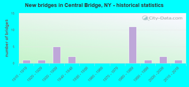
- New bridges - historical statistics
- 11910-1919
- 11920-1929
- 51930-1939
- 21940-1949
- 111980-1989
- 11990-1999
- 22000-2009
- 12010-2019

- Reconstructed bridges - Historical Statistics
- 11990-1999
- 12000-2009
- 12010-2019
- 12020-2022


- Bridge Condition - Deck
- 6.7%Excellent
- 6.7%Very good
- 40.0%Good
- 33.3%Satisfactory
- 6.7%Fair
- 6.7%Poor

- Bridge Condition - Superstructure
- 6.3%Excellent
- 12.5%Very good
- 68.8%Good
- 12.5%Poor

- Bridge Condition - Substructure
- 18.8%Excellent
- 6.3%Very good
- 37.5%Good
- 25.0%Satisfactory
- 12.5%Fair

- Bridge Condition - Channel
- 15.4%Very good
- 30.8%Good
- 38.5%Satisfactory
- 7.7%Fair
- 7.7%Poor
Find on map >> Show street view
Structure Number: 100413, Location: 0.7 MI N W I-88 EXIT 23 (Lat: 42.707553, Lng: -74.326292), Route carried "on" structure: State highway 7, Year Built: 2000, Status: Open, Structure Length: 11.06m (36.29ft), Average Daily Traffic: 3,214 (year 2020), Truck Traffic: 17%, Average Future Daily Traffic: 3,233 (year 2040), Design Load: HS 25 or greater, Features Intersected: SCHOHARIE CREEK
Minimum Vertical Clearance: 30+ m (98+ ft), Kilometerpoint: 29.123, Lanes on structure: 2, Base Highway Network: Yes, Owner: State Highway Agency, Approaching Roadway Width: 10.7m (35.1ft), Skew: 2 degrees, Material/Design: Steel continuous, Design/Construction: Stringer/Multi-beam, Number Of Spans In Main Unit: 2, Length of Maximum Span: 54.8m (179.8ft), Curb-To-Curb Width: 10.8m (35.4ft), Out-to-Out Width: 11.8m (38.7ft)
Condition: Deck: Satisfactory, Superstructure: Good, Substructure: Satisfactory, Channel: Good, Operating Rating: 68.9 metric tons, Method Used To Determine Operating Rating: Load Factor (LF), Inventory Rating: 41.7 metric tons, Method Used To Determine Inventory Rating: Load Factor (LF), Structural Evaluation: Equal to present minimum criteria, Deck Geometry: Somewhat better than minimum adequacy, Waterway Adequacy: Somewhat better than minimum adequacy, Approach Roadway Alignment: Equal to present desirable criteria, Length Of Structure Improvement: 11.06m (36.29ft), Designated Inspection Frequency: Every 24 months, Underwater Inspection Frequency: Every 60 months, Inspection Date: May 2020, Underwater Inspection Date: November 2016, Bridge Improvement Cost: $2,914,000, Roadway Improvement Cost: $1,706,000, Total Project Cost: $4,620,000 ( Estimate for 2021), Deck Structure Type: Concrete Cast-file-Place, Wearing Surface/Protective System: Wearing Surface: Epoxy Overlay, Deck Protection: Epoxy Coated Reinforcing
Find on map >> Show street view
Structure Number: 10159, Location: 0.3 MI W JCT US 20 & SH 3 (Lat: 42.757142, Lng: -74.336044), Route carried "on" structure: US 20, Year Built: 1941, Year Reconstructed: 2013, Status: Open, Structure Length: 1.31m (4.30ft), Average Daily Traffic: 2,232 (year 2017), Truck Traffic: 15%, Average Future Daily Traffic: 2,253 (year 2040), Design Load: HS 20, Features Intersected: FLY CREEK
Minimum Vertical Clearance: 30+ m (98+ ft), Kilometerpoint: 27.659, Lanes on structure: 3, Base Highway Network: Yes, Owner: State Highway Agency, Approaching Roadway Width: 19.5m (64.0ft), Skew: 3 degrees, Material/Design: Steel, Design/Construction: Stringer/Multi-beam, Number Of Spans In Main Unit: 1, Length of Maximum Span: 12.8m (42.0ft), Curb-To-Curb Width: 19.6m (64.3ft), Out-to-Out Width: 20.2m (66.3ft)
Condition: Deck: Good, Superstructure: Good, Substructure: Good, Channel: Satisfactory, Operating Rating: 97.2 metric tons, Method Used To Determine Operating Rating: Load and Resistance Factor Rating (LRFR) rating reported by rating factor(RF) method using HL-93 loadings, Inventory Rating: 78.1 metric tons, Method Used To Determine Inventory Rating: Load and Resistance Factor Rating (LRFR) rating reported by rating factor(RF) method using HL-93 loadings, Structural Evaluation: Better than present minimum criteria, Deck Geometry: Superior to present desirable criteria, Waterway Adequacy: Somewhat better than minimum adequacy, Approach Roadway Alignment: Equal to present desirable criteria, Length Of Structure Improvement: 1.31m (4.30ft), Designated Inspection Frequency: Every 24 months, Inspection Date: July 2021, Bridge Improvement Cost: $1,221,000, Roadway Improvement Cost: $715,000, Total Project Cost: $1,936,000 ( Estimate for 2021), Deck Structure Type: Concrete Cast-file-Place, Wearing Surface/Protective System: Wearing Surface: Integral Concrete, Deck Protection: Epoxy Coated Reinforcing
Find on map >> Show street view
Structure Number: 102136, Location: 0.1 MI N JCT SH 30A & SH (Lat: 42.707419, Lng: -74.335175), Route carried "on" structure: State highway 30A, Year Built: 1997, Status: Open, Structure Length: 5.64m (18.50ft), Average Daily Traffic: 1,473 (year 2015), Truck Traffic: 23%, Average Future Daily Traffic: 1,482 (year 2040), Design Load: HS 25 or greater, Features Intersected: COBLESKILL CREEK
Minimum Vertical Clearance: 30+ m (98+ ft), Kilometerpoint: 3.765, Lanes on structure: 2, Base Highway Network: Yes, Owner: State Highway Agency, Approaching Roadway Width: 12.2m (40.0ft), Skew: 4 degrees, Material/Design: Steel, Design/Construction: Stringer/Multi-beam, Number Of Spans In Main Unit: 1, Length of Maximum Span: 54.8m (179.8ft), Curb-To-Curb Width: 12.2m (40.0ft), Out-to-Out Width: 12.8m (42.0ft)
Condition: Deck: Fair, Superstructure: Good, Substructure: Good, Channel: Satisfactory, Operating Rating: 71.7 metric tons, Method Used To Determine Operating Rating: Load Factor (LF), Inventory Rating: 42.6 metric tons, Method Used To Determine Inventory Rating: Load Factor (LF), Structural Evaluation: Better than present minimum criteria, Deck Geometry: Better than present minimum criteria, Waterway Adequacy: Meets minimum limits, Approach Roadway Alignment: Equal to present desirable criteria, Length Of Structure Improvement: 5.63m (18.47ft), Designated Inspection Frequency: Every 24 months, Inspection Date: September 2020, Bridge Improvement Cost: $2,104,000, Roadway Improvement Cost: $1,232,000, Total Project Cost: $3,337,000 ( Estimate for 2021), Deck Structure Type: Concrete Cast-file-Place, Wearing Surface/Protective System: Wearing Surface: Integral Concrete, Deck Protection: Epoxy Coated Reinforcing
Find on map >> Show street view
Structure Number: 102138, Location: 1.4 MI S JCT SH 30A & US (Lat: 42.739747, Lng: -74.334261), Route carried "on" structure: State highway 30A, Year Built: 1930, Status: Open, Structure Length: 1.07m (3.51ft), Average Daily Traffic: 1,473 (year 2015), Truck Traffic: 23%, Average Future Daily Traffic: 1,482 (year 2040), Features Intersected: CRIPPLEBUSH CREEK
Minimum Vertical Clearance: 30+ m (98+ ft), Kilometerpoint: 7.450, Lanes on structure: 2, Base Highway Network: Yes, Owner: State Highway Agency, Approaching Roadway Width: 11.0m (36.1ft), Skew: 3 degrees, Material/Design: Concrete, Design/Construction: Tee Beam, Number Of Spans In Main Unit: 1, Length of Maximum Span: 10.3m (33.8ft), Curb-To-Curb Width: 10.7m (35.1ft), Out-to-Out Width: 11.3m (37.1ft)
Condition: Deck: Poor, Superstructure: Poor, Substructure: Fair, Channel: Poor, Operating Rating: 63.6 metric tons, Method Used To Determine Operating Rating: Field evaluation and documented engineering judgment, Inventory Rating: 24.5 metric tons, Method Used To Determine Inventory Rating: Field evaluation and documented engineering judgment, Structural Evaluation: Meets minimum limits, Deck Geometry: Equal to present minimum criteria, Waterway Adequacy: Meets minimum limits, Approach Roadway Alignment: Equal to present desirable criteria, Length Of Structure Improvement: 1.06m (3.48ft), Designated Inspection Frequency: Every 24 months, Inspection Date: September 2020, Bridge Improvement Cost: $629,000, Roadway Improvement Cost: $368,000, Total Project Cost: $997,000 ( Estimate for 2021), Deck Structure Type: Concrete Cast-file-Place, Wearing Surface/Protective System: Wearing Surface: Bituminous
Find on map >> Show street view
Structure Number: 102139, Location: 0.9 MI S JCT RTS 30A + 20 (Lat: 42.745228, Lng: -74.327147), Route carried "on" structure: State highway 30A, Year Built: 1933, Year Reconstructed: 1997, Status: Open, Structure Length: 1.95m (6.40ft), Average Daily Traffic: 2,710 (year 2018), Truck Traffic: 18%, Average Future Daily Traffic: 2,726 (year 2040), Design Load: HS 25 or greater, Features Intersected: FLY CREEK
Minimum Vertical Clearance: 30+ m (98+ ft), Kilometerpoint: 8.319, Lanes on structure: 2, Base Highway Network: Yes, Owner: State Highway Agency, Approaching Roadway Width: 12.2m (40.0ft), Skew: 3 degrees, Material/Design: Steel, Design/Construction: Stringer/Multi-beam, Number Of Spans In Main Unit: 1, Length of Maximum Span: 18.2m (59.7ft), Curb-To-Curb Width: 12.2m (40.0ft), Out-to-Out Width: 12.8m (42.0ft)
Condition: Deck: Good, Superstructure: Good, Substructure: Satisfactory, Channel: Good, Operating Rating: 62.2 metric tons, Method Used To Determine Operating Rating: Load and Resistance Factor Rating (LRFR) rating reported by rating factor(RF) method using HL-93 loadings, Inventory Rating: 48.0 metric tons, Method Used To Determine Inventory Rating: Load and Resistance Factor Rating (LRFR) rating reported by rating factor(RF) method using HL-93 loadings, Structural Evaluation: Equal to present minimum criteria, Deck Geometry: Equal to present minimum criteria, Waterway Adequacy: Somewhat better than minimum adequacy, Approach Roadway Alignment: Equal to present desirable criteria, Length Of Structure Improvement: 1.95m (6.40ft), Designated Inspection Frequency: Every 24 months, Inspection Date: June 2021, Bridge Improvement Cost: $1,011,000, Roadway Improvement Cost: $592,000, Total Project Cost: $1,603,000 ( Estimate for 2021), Deck Structure Type: Concrete Cast-file-Place, Wearing Surface/Protective System: Wearing Surface: Integral Concrete, Deck Protection: Epoxy Coated Reinforcing
Find on map >> Show street view
Structure Number: 1070611, Location: ONE MI SE OF HOWES CAVE (Lat: 42.681831, Lng: -74.371675), Route carried "on" structure: Interstate 88, Year Built: 1981, Status: Open, Structure Length: 3.57m (11.71ft), Average Daily Traffic: 5,823 (year 2007), Truck Traffic: 21%, Design Load: HS 20+Mod, Features Intersected: WETSEL HOLLOW ROAD
Minimum Vertical Clearance: 30+ m (98+ ft), Kilometerpoint: 23.202, Lanes on structure: 2, Lanes under structure: 2, Base Highway Network: Yes, Owner: State Highway Agency, Approaching Roadway Width: 11.6m (38.1ft), Skew: 1 degrees, Material/Design: Steel, Design/Construction: Stringer/Multi-beam, Number Of Spans In Main Unit: 1, Length of Maximum Span: 34.7m (113.8ft), Curb-To-Curb Width: 12.5m (41.0ft), Out-to-Out Width: 13.6m (44.6ft)
Condition: Deck: Satisfactory, Superstructure: Good, Substructure: Good, Operating Rating: 60.3 metric tons, Method Used To Determine Operating Rating: Load and Resistance Factor Rating (LRFR) rating reported by rating factor(RF) method using HL-93 loadings, Inventory Rating: 46.3 metric tons, Method Used To Determine Inventory Rating: Load and Resistance Factor Rating (LRFR) rating reported by rating factor(RF) method using HL-93 loadings, Structural Evaluation: Better than present minimum criteria, Deck Geometry: Better than present minimum criteria, Underclear: Meets minimum limits, Approach Roadway Alignment: Equal to present desirable criteria, Length Of Structure Improvement: 3.56m (11.68ft), Designated Inspection Frequency: Every 24 months, Inspection Date: June 2021, Bridge Improvement Cost: $1,420,000, Roadway Improvement Cost: $832,000, Total Project Cost: $2,252,000 ( Estimate for 2021), Deck Structure Type: Concrete Cast-file-Place, Wearing Surface/Protective System: Wearing Surface: Integral Concrete, Deck Protection: Epoxy Coated Reinforcing
Find on map >> Show street view
Structure Number: 1070612, Location: ONE MI SE OF HOWES CAVE (Lat: 42.681528, Lng: -74.371353), Route carried "on" structure: Interstate 88, Year Built: 1981, Status: Open, Structure Length: 3.57m (11.71ft), Average Daily Traffic: 4,725 (year 2020), Truck Traffic: 26%, Average Future Daily Traffic: 5,627 (year 2040), Design Load: HS 20+Mod, Features Intersected: WETSEL HOLLOW ROAD
Minimum Vertical Clearance: 30+ m (98+ ft), Kilometerpoint: 23.186, Lanes on structure: 2, Lanes under structure: 2, Base Highway Network: Yes, Owner: State Highway Agency, Approaching Roadway Width: 11.6m (38.1ft), Skew: 1 degrees, Material/Design: Steel, Design/Construction: Stringer/Multi-beam, Number Of Spans In Main Unit: 1, Length of Maximum Span: 34.7m (113.8ft), Curb-To-Curb Width: 12.5m (41.0ft), Out-to-Out Width: 13.6m (44.6ft)
Condition: Deck: Satisfactory, Superstructure: Good, Substructure: Good, Operating Rating: 60.3 metric tons, Method Used To Determine Operating Rating: Load and Resistance Factor Rating (LRFR) rating reported by rating factor(RF) method using HL-93 loadings, Inventory Rating: 46.7 metric tons, Method Used To Determine Inventory Rating: Load and Resistance Factor Rating (LRFR) rating reported by rating factor(RF) method using HL-93 loadings, Structural Evaluation: Better than present minimum criteria, Deck Geometry: Better than present minimum criteria, Underclear: Meets minimum limits, Approach Roadway Alignment: Equal to present desirable criteria, Length Of Structure Improvement: 3.56m (11.68ft), Designated Inspection Frequency: Every 24 months, Inspection Date: June 2021, Bridge Improvement Cost: $1,454,000, Roadway Improvement Cost: $852,000, Total Project Cost: $2,306,000 ( Estimate for 2021), Deck Structure Type: Concrete Cast-file-Place, Wearing Surface/Protective System: Wearing Surface: Integral Concrete, Deck Protection: Epoxy Coated Reinforcing
Find on map >> Show street view
Structure Number: 1070621, Location: 5.3 M E JCT I88 & RTE 145 (Lat: 42.705875, Lng: -74.321944), Route carried "on" structure: Interstate 88, Year Built: 1981, Status: Open, Structure Length: 16.52m (54.20ft), Average Daily Traffic: 5,823 (year 2007), Truck Traffic: 21%, Average Future Daily Traffic: 8,152 (year 2027), Design Load: HS 20+Mod, Features Intersected: SMITH ROAD, SCHOHARIE CR
Minimum Vertical Clearance: 30+ m (98+ ft), Kilometerpoint: 28.045, Lanes on structure: 2, Lanes under structure: 2, Base Highway Network: Yes, Owner: State Highway Agency, Approaching Roadway Width: 12.8m (42.0ft), Skew: 2 degrees, Material/Design: Steel continuous, Design/Construction: Stringer/Multi-beam, Number Of Spans In Main Unit: 3, Length of Maximum Span: 64.0m (210.0ft), Curb-To-Curb Width: 13.1m (43.0ft), Out-to-Out Width: 13.7m (44.9ft)
Condition: Deck: Satisfactory, Superstructure: Good, Substructure: Excellent, Channel: Very good, Operating Rating: 68.0 metric tons, Method Used To Determine Operating Rating: Load Factor (LF), Inventory Rating: 40.8 metric tons, Method Used To Determine Inventory Rating: Load Factor (LF), Structural Evaluation: Better than present minimum criteria, Deck Geometry: Superior to present desirable criteria, Underclear: Meets minimum limits, Waterway Adequacy: Meets minimum limits, Approach Roadway Alignment: Equal to present desirable criteria, Length Of Structure Improvement: 16.52m (54.20ft), Designated Inspection Frequency: Every 24 months, Inspection Date: November 2020, Bridge Improvement Cost: $4,923,000, Roadway Improvement Cost: $2,883,000, Total Project Cost: $7,806,000 ( Estimate for 2021), Deck Structure Type: Concrete Cast-file-Place, Wearing Surface/Protective System: Wearing Surface: Integral Concrete, Deck Protection: Epoxy Coated Reinforcing
Find on map >> Show street view
Structure Number: 1070622, Location: 5.3 M E JCT I88 & RTE 145 (Lat: 42.705561, Lng: -74.321669), Route carried "on" structure: Interstate 88, Year Built: 1981, Status: Open, Structure Length: 16.52m (54.20ft), Average Daily Traffic: 4,725 (year 2020), Truck Traffic: 26%, Average Future Daily Traffic: 5,627 (year 2040), Design Load: HS 20+Mod, Features Intersected: SMITH ROAD, SCHOHARIE CR
Minimum Vertical Clearance: 30+ m (98+ ft), Kilometerpoint: 28.045, Lanes on structure: 2, Lanes under structure: 2, Base Highway Network: Yes, Owner: State Highway Agency, Approaching Roadway Width: 12.8m (42.0ft), Skew: 2 degrees, Material/Design: Steel continuous, Design/Construction: Stringer/Multi-beam, Number Of Spans In Main Unit: 3, Length of Maximum Span: 64.0m (210.0ft), Curb-To-Curb Width: 12.8m (42.0ft), Out-to-Out Width: 13.4m (44.0ft)
Condition: Deck: Good, Superstructure: Good, Substructure: Excellent, Channel: Very good, Operating Rating: 61.7 metric tons, Method Used To Determine Operating Rating: Load Factor (LF), Inventory Rating: 36.3 metric tons, Method Used To Determine Inventory Rating: Load Factor (LF), Structural Evaluation: Better than present minimum criteria, Deck Geometry: Equal to present desirable criteria, Underclear: Meets minimum limits, Waterway Adequacy: Equal to present minimum criteria, Approach Roadway Alignment: Equal to present desirable criteria, Length Of Structure Improvement: 16.52m (54.20ft), Designated Inspection Frequency: Every 24 months, Inspection Date: November 2020, Bridge Improvement Cost: $4,781,000, Roadway Improvement Cost: $2,800,000, Total Project Cost: $7,580,000 ( Estimate for 2021), Deck Structure Type: Concrete Cast-file-Place, Wearing Surface/Protective System: Wearing Surface: Integral Concrete, Deck Protection: Epoxy Coated Reinforcing
Find on map >> Show street view
Structure Number: 107063, Location: JCT RELOCATED RTS 30A&I88 (Lat: 42.706864, Lng: -74.313742), Route carried "on" structure: State highway 30A, Year Built: 1981, Status: Open, Structure Length: 8.21m (26.94ft), Average Daily Traffic: 6,771 (year 2020), Truck Traffic: 11%, Average Future Daily Traffic: 6,812 (year 2040), Design Load: HS 20+Mod, Features Intersected: 88I 88I95071179, RTE I88
Minimum Vertical Clearance: 30+ m (98+ ft), Kilometerpoint: 1.239, Lanes on structure: 2, Lanes under structure: 4, Base Highway Network: Yes, Owner: State Highway Agency, Approaching Roadway Width: 19.5m (64.0ft), Skew: 20 degrees, Material/Design: Steel continuous, Design/Construction: Stringer/Multi-beam, Number Of Spans In Main Unit: 2, Length of Maximum Span: 40.5m (132.9ft), Curb-To-Curb Width: 19.2m (63.0ft), Out-to-Out Width: 20.1m (65.9ft)
Condition: Deck: Good, Superstructure: Good, Substructure: Satisfactory, Operating Rating: 67.1 metric tons, Method Used To Determine Operating Rating: Load Factor (LF), Inventory Rating: 39.9 metric tons, Method Used To Determine Inventory Rating: Load Factor (LF), Structural Evaluation: Equal to present minimum criteria, Deck Geometry: Superior to present desirable criteria, Underclear: High priority of corrective action, Approach Roadway Alignment: Equal to present desirable criteria, Length Of Structure Improvement: 8.21m (26.94ft), Designated Inspection Frequency: Every 24 months, Inspection Date: October 2020, Bridge Improvement Cost: $3,899,000, Roadway Improvement Cost: $2,283,000, Total Project Cost: $6,182,000 ( Estimate for 2021), Deck Structure Type: Concrete Cast-file-Place, Wearing Surface/Protective System: Wearing Surface: Integral Concrete, Deck Protection: Epoxy Coated Reinforcing
Find on map >> Show street view
Structure Number: 226993, Location: 1 MI S OF JCT US20 &SH30A (Lat: 42.741606, Lng: -74.347839), Route carried "on" structure: Other road , Year Built: 1940, Year Reconstructed: 2019, Status: Open, Structure Length: 1.01m (3.31ft), Features Intersected: CRIPPLEBUSH CREEK, Facility Carried by Structure: CRIPPLEBUSH RD
Minimum Vertical Clearance: 30+ m (98+ ft), Kilometerpoint: 0.418, Lanes on structure: 1, Owner: County Highway Agency, Approaching Roadway Width: 5.5m (18.0ft), Material/Design: Steel, Design/Construction: Stringer/Multi-beam, Number Of Spans In Main Unit: 1, Length of Maximum Span: 9.4m (30.8ft), Curb-To-Curb Width: 8.0m (26.2ft), Out-to-Out Width: 8.6m (28.2ft)
Condition: Deck: Excellent, Superstructure: Excellent, Substructure: Satisfactory, Channel: Fair, Operating Rating: 67.1 metric tons, Method Used To Determine Operating Rating: Allowable Stress (AS), Inventory Rating: 49.9 metric tons, Method Used To Determine Inventory Rating: Allowable Stress (AS), Structural Evaluation: Equal to present minimum criteria, Deck Geometry: Equal to present minimum criteria, Waterway Adequacy: Equal to present desirable criteria, Approach Roadway Alignment: High priority of corrective action, Length Of Structure Improvement: 1.00m (3.28ft), Designated Inspection Frequency: Every 24 months, Inspection Date: April 2020, Bridge Improvement Cost: $232,000, Roadway Improvement Cost: $136,000, Total Project Cost: $369,000 ( Estimate for 2021), Deck Structure Type: Wood or Timber, Wearing Surface/Protective System: Wearing Surface: Bituminous
Find on map >> Show street view
Structure Number: 335462, Location: .5 MI SE OF HOWES CAVE (Lat: 42.684694, Lng: -74.374467), Route carried "on" structure: County highway , Year Built: 1986, Status: Open, Structure Length: 4.79m (15.72ft), Average Daily Traffic: 751 (year 2017), Truck Traffic: 26%, Average Future Daily Traffic: 1,051 (year 2037), Design Load: HS 20, Features Intersected: COBLESKILL CREEK, Facility Carried by Structure: COUNTY ROAD 8
Minimum Vertical Clearance: 30+ m (98+ ft), Kilometerpoint: 1.866, Lanes on structure: 2, Owner: County Highway Agency, Approaching Roadway Width: 8.5m (27.9ft), Skew: 2 degrees, Material/Design: Steel, Design/Construction: Stringer/Multi-beam, Number Of Spans In Main Unit: 1, Length of Maximum Span: 46.3m (151.9ft), Curb-To-Curb Width: 8.6m (28.2ft), Out-to-Out Width: 9.1m (29.9ft)
Condition: Deck: Good, Superstructure: Good, Substructure: Good, Channel: Satisfactory, Operating Rating: 93.4 metric tons, Method Used To Determine Operating Rating: Load Factor (LF), Inventory Rating: 55.3 metric tons, Method Used To Determine Inventory Rating: Load Factor (LF), Structural Evaluation: Better than present minimum criteria, Deck Geometry: Somewhat better than minimum adequacy, Waterway Adequacy: Meets minimum limits, Approach Roadway Alignment: Equal to present desirable criteria, Length Of Structure Improvement: 4.78m (15.68ft), Designated Inspection Frequency: Every 24 months, Inspection Date: November 2021, Bridge Improvement Cost: $1,286,000, Roadway Improvement Cost: $753,000, Total Project Cost: $2,039,000 ( Estimate for 2021), Deck Structure Type: Concrete Cast-file-Place, Wearing Surface/Protective System: Wearing Surface: Integral Concrete, Deck Protection: Epoxy Coated Reinforcing
Find on map >> Show street view
Structure Number: 335463, Location: CENTRAL BRIDGE (Lat: 42.707150, Lng: -74.339167), Route carried "on" structure: County highway , Year Built: 1914, Year Reconstructed: 2020, Status: Open, Structure Length: 4.60m (15.09ft), Average Daily Traffic: 366 (year 2017), Truck Traffic: 6%, Average Future Daily Traffic: 512 (year 2037), Design Load: HS 25 or greater, Features Intersected: COBLESKILL CREEK, Facility Carried by Structure: CHURCH STREET
Minimum Vertical Clearance: 30+ m (98+ ft), Kilometerpoint: 0.354, Lanes on structure: 2, Owner: County Highway Agency, Approaching Roadway Width: 5.2m (17.1ft), Material/Design: Steel, Design/Construction: Truss - Thru, Number Of Spans In Main Unit: 1, Number Of Approach Spans: 1, Length of Maximum Span: 41.1m (134.8ft), Curb-To-Curb Width: 5.2m (17.1ft), Out-to-Out Width: 5.5m (18.0ft)
Condition: Deck: Very good, Superstructure: Good, Substructure: Good, Channel: Good, Operating Rating: 67.1 metric tons, Method Used To Determine Operating Rating: Load Factor (LF), Inventory Rating: 39.9 metric tons, Method Used To Determine Inventory Rating: Load Factor (LF), Structural Evaluation: Better than present minimum criteria, Deck Geometry: High priority of replacement, Waterway Adequacy: Somewhat better than minimum adequacy, Approach Roadway Alignment: Equal to present minimum criteria, Length Of Structure Improvement: 4.60m (15.09ft), Designated Inspection Frequency: Every 24 months, Critical Feature Inspection Frequency: Every 24 months, Inspection Date: August 2021, Critical Feature Inspection Date: August 2021, Bridge Improvement Cost: $1,867,000, Roadway Improvement Cost: $1,094,000, Total Project Cost: $2,961,000 ( Estimate for 2021), Wearing Surface/Protective System: Wearing Surface: Bituminous
Find on map >> Show street view
Structure Number: 335464, Location: .1 MI SOUTH OF SLOANSVILL (Lat: 42.743067, Lng: -74.327389), Route carried "on" structure: County highway , Year Built: 2006, Status: Open, Structure Length: 9.27m (30.41ft), Average Daily Traffic: 1,470 (year 2017), Truck Traffic: 8%, Average Future Daily Traffic: 2,058 (year 2037), Features Intersected: SCHOHARIE CREEK, Facility Carried by Structure: CR27 JUNCTION RD
Minimum Vertical Clearance: 5.51m (18.08ft), Kilometerpoint: 4.360, Lanes on structure: 2, Owner: County Highway Agency, Approaching Roadway Width: 7.9m (25.9ft), Material/Design: Steel, Design/Construction: Truss - Thru, Number Of Spans In Main Unit: 1, Length of Maximum Span: 92.4m (303.1ft), Curb-To-Curb Width: 7.8m (25.6ft), Out-to-Out Width: 8.7m (28.5ft)
Condition: Deck: Good, Superstructure: Very good, Substructure: Very good, Channel: Good, Operating Rating: 66.0 metric tons, Method Used To Determine Operating Rating: Load Factor (LF), Inventory Rating: 37.0 metric tons, Method Used To Determine Inventory Rating: Load Factor (LF), Structural Evaluation: Equal to present desirable criteria, Deck Geometry: Meets minimum limits, Waterway Adequacy: Somewhat better than minimum adequacy, Approach Roadway Alignment: Equal to present desirable criteria, Length Of Structure Improvement: 9.26m (30.38ft), Designated Inspection Frequency: Every 24 months, Critical Feature Inspection Frequency: Every 24 months, Inspection Date: October 2020, Critical Feature Inspection Date: October 2020, Bridge Improvement Cost: $5,861,000, Roadway Improvement Cost: $3,432,000, Total Project Cost: $9,292,000 ( Estimate for 2021), Deck Structure Type: Concrete Cast-file-Place, Wearing Surface/Protective System: Wearing Surface: Integral Concrete, Deck Protection: Epoxy Coated Reinforcing
Find on map >> Show street view
Structure Number: 335502, Location: 4.6 MI E OF COBLESKILL (Lat: 42.686056, Lng: -74.399925), Route carried "on" structure: County highway , Year Built: 2015, Status: Open, Structure Length: 3.14m (10.30ft), Average Daily Traffic: 67 (year 2017), Truck Traffic: 7%, Average Future Daily Traffic: 94 (year 2037), Design Load: HL 93, Features Intersected: COBLESKILL CREEK, Facility Carried by Structure: HOWES CAVE ROAD
Minimum Vertical Clearance: 30+ m (98+ ft), Kilometerpoint: 0.097, Lanes on structure: 2, Owner: County Highway Agency, Approaching Roadway Width: 7.3m (24.0ft), Material/Design: Concrete, Design/Construction: Arch - Deck, Number Of Spans In Main Unit: 1, Length of Maximum Span: 31.1m (102.0ft), Curb-To-Curb Width: 8.0m (26.2ft), Out-to-Out Width: 8.7m (28.5ft)
Condition: Superstructure: Very good, Substructure: Excellent, Channel: Satisfactory, Operating Rating: 94.7 metric tons, Method Used To Determine Operating Rating: Field evaluation and documented engineering judgment, Inventory Rating: 40.8 metric tons, Method Used To Determine Inventory Rating: Field evaluation and documented engineering judgment, Structural Evaluation: Equal to present desirable criteria, Deck Geometry: Equal to present minimum criteria, Waterway Adequacy: Equal to present minimum criteria, Approach Roadway Alignment: Meets minimum limits, Length Of Structure Improvement: 3.13m (10.27ft), Designated Inspection Frequency: Every 24 months, Inspection Date: November 2021, Bridge Improvement Cost: $1,321,000, Roadway Improvement Cost: $774,000, Total Project Cost: $2,095,000 ( Estimate for 2021), Wearing Surface/Protective System: Wearing Surface: Bituminous
Find on map >> Show street view
Structure Number: 335503, Location: 6 MI EAST OF COBLESKILL (Lat: 42.688686, Lng: -74.405461), Route carried "on" structure: County highway , Year Built: 1928, Status: Posted for load, Structure Length: 2.90m (9.51ft), Average Daily Traffic: 356 (year 2020), Truck Traffic: 9%, Average Future Daily Traffic: 432 (year 2040), Features Intersected: COBLESKILL CREEK, Facility Carried by Structure: COUNTY ROAD 9
Minimum Vertical Clearance: 30+ m (98+ ft), Kilometerpoint: 0.595, Lanes on structure: 2, Owner: County Highway Agency, Approaching Roadway Width: 5.5m (18.0ft), Material/Design: Steel, Design/Construction: Truss - Thru, Number Of Spans In Main Unit: 1, Length of Maximum Span: 28.7m (94.2ft), Curb-To-Curb Width: 6.1m (20.0ft), Out-to-Out Width: 6.6m (21.7ft)
Condition: Deck: Satisfactory, Superstructure: Poor, Substructure: Fair, Channel: Satisfactory, Operating Rating: 39.0 metric tons, Method Used To Determine Operating Rating: Load Factor (LF), Inventory Rating: 22.7 metric tons, Method Used To Determine Inventory Rating: Load Factor (LF), Structural Evaluation: Meets minimum limits, Deck Geometry: Meets minimum limits, Waterway Adequacy: Meets minimum limits, Approach Roadway Alignment: Meets minimum limits, Bridge Posting: Required (Relationship of Operating Rating to Maximum Legal Load: > 39.9% below), Length Of Structure Improvement: 2.89m (9.48ft), Designated Inspection Frequency: Every 12 months, Critical Feature Inspection Frequency: Every 12 months, Inspection Date: June 2021, Critical Feature Inspection Date: June 2021, Bridge Improvement Cost: $1,510,000, Roadway Improvement Cost: $884,000, Total Project Cost: $2,394,000 ( Estimate for 2021), Deck Structure Type: Concrete Cast-file-Place, Wearing Surface/Protective System: Wearing Surface: Bituminous, Membrane: Preformed Fabric
Find on map >> Show street view
Structure Number: 1070611, Location: ONE MI SE OF HOWES CAVE (Lat: 42.681831, Lng: -74.371675), Route carried "under" structure: County highway , Year Built: 1981, Structure Length: 0. m, Features Intersected: WETSEL HOLLOW ROAD, Facility Carried by Structure: RTE I88
Minimum Vertical Clearance: 5.07m (16.63ft), Kilometerpoint: 1.754, Lanes on structure: 2, Lanes under structure: 2, Material/Design: Steel, Design/Construction: Stringer/Multi-beam, Length of Maximum Span: 34.7m (113.8ft)
Find on map >> Show street view
Structure Number: 1070612, Location: ONE MI SE OF HOWES CAVE (Lat: 42.681528, Lng: -74.371353), Route carried "under" structure: County highway , Year Built: 1981, Structure Length: 0. m, Features Intersected: WETSEL HOLLOW ROAD, Facility Carried by Structure: RTE I88
Minimum Vertical Clearance: 4.72m (15.49ft), Kilometerpoint: 0.000, Lanes on structure: 2, Lanes under structure: 2, Material/Design: Steel, Design/Construction: Stringer/Multi-beam, Length of Maximum Span: 34.7m (113.8ft)
Find on map >> Show street view
Structure Number: 1070621, Location: 5.3 M E JCT I88 & RTE 145 (Lat: 42.705875, Lng: -74.321944), Route carried "under" structure: Other road , Year Built: 1981, Structure Length: 0. m, Features Intersected: SMITH ROAD, SCHOHARIE CR, Facility Carried by Structure: RTE I88
Minimum Vertical Clearance: 4.50m (14.76ft), Kilometerpoint: 1.126, Lanes on structure: 2, Lanes under structure: 2, Material/Design: Steel continuous, Design/Construction: Stringer/Multi-beam, Length of Maximum Span: 64.0m (210.0ft)
Find on map >> Show street view
Structure Number: 1070622, Location: 5.3 M E JCT I88 & RTE 145 (Lat: 42.705561, Lng: -74.321669), Route carried "under" structure: Other road , Year Built: 1981, Structure Length: 0. m, Features Intersected: SMITH ROAD, SCHOHARIE CR, Facility Carried by Structure: RTE I88
Minimum Vertical Clearance: 4.80m (15.75ft), Kilometerpoint: 0.901, Lanes on structure: 2, Lanes under structure: 2, Material/Design: Steel continuous, Design/Construction: Stringer/Multi-beam, Length of Maximum Span: 64.0m (210.0ft)
Find on map >> Show street view
Structure Number: 107063, Location: JCT RELOCATED RTS 30A&I88 (Lat: 42.706864, Lng: -74.313742), Route carried "under" structure: Interstate 88, Year Built: 1981, Structure Length: 0. m, Average Daily Traffic: 2,000 (year 1980), Features Intersected: 88I 88I95071179, RTE I88, Facility Carried by Structure: RTE 30A
Minimum Vertical Clearance: 6.73m (22.08ft), Kilometerpoint: 28.849, Lanes on structure: 2, Lanes under structure: 2, Material/Design: Steel continuous, Design/Construction: Stringer/Multi-beam, Length of Maximum Span: 40.5m (132.9ft)
Find on map >> Show street view
Structure Number: 702137, Location: .5 MI N JCT SH 30A & SH 7 (Lat: 42.713414, Lng: -74.335267), Route carried "under" structure: State highway , Year Built: 1938, Structure Length: 0. m, Average Daily Traffic: 1,994 (year 2000), Features Intersected: 30A 30A 95011027, Facility Carried by Structure: NORFOLK SOUTHERN M
Minimum Vertical Clearance: 4.62m (15.16ft), Kilometerpoint: 4.296, Lanes under structure: 2, Material/Design: Steel, Design/Construction: Girder and Floorbeam System, Length of Maximum Span: 12.2m (40.0ft)
Find on map >> Show street view
Structure Number: 7714591, Location: 1.7 MI NE CENTRAL BRIDGE (Lat: 42.736331, Lng: -74.321022), Route carried "under" structure: County highway , Year Built: 1930, Structure Length: 0. m, Average Daily Traffic: 735 (year 2017), Truck Traffic: 8%, Features Intersected: CR 27-JUNCTION RD, Facility Carried by Structure: DELAWARE & HUDSON
Minimum Vertical Clearance: 3.63m (11.91ft), Kilometerpoint: 3.620, Lanes under structure: 2, Material/Design: Steel, Design/Construction: Girder and Floorbeam System, Length of Maximum Span: 9.4m (30.8ft)
Find on map >> Show street view
Structure Number: 7714592, Location: 1.7 MI NE CENTRAL BRIDGE (Lat: 42.736364, Lng: -74.321119), Route carried "under" structure: County highway , Year Built: 1930, Structure Length: 0. m, Average Daily Traffic: 735 (year 2017), Truck Traffic: 8%, Features Intersected: CR 27-JUNCTION RD, Facility Carried by Structure: DELAWARE & HUDSON
Minimum Vertical Clearance: 3.63m (11.91ft), Kilometerpoint: 3.733, Lanes under structure: 2, Material/Design: Steel, Design/Construction: Girder and Floorbeam System, Length of Maximum Span: 9.4m (30.8ft)