Bridge Statistics for Central Gardens, Texas (TX)
Condition, Traffic, Stress, Structural Evaluation, Project Costs
- National Bridge Inventory (NBI) Statistics
- 11Number of bridges
- 72ft / 21.8mTotal length
- $183,000Total costs
- 142,106Total average daily traffic
- 7,417Total average daily truck traffic
- National Bridge Inventory (NBI) Registered Bridges for Central Gardens
- No street view available for this location
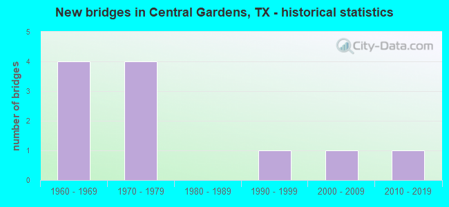
- New bridges - historical statistics
- 41960-1969
- 41970-1979
- 11990-1999
- 12000-2009
- 12010-2019


- Bridge Condition - Deck
- 14.3%Very good
- 85.7%Good

- Bridge Condition - Superstructure
- 14.3%Very good
- 71.4%Good
- 14.3%Fair

- Bridge Condition - Substructure
- 85.7%Good
- 14.3%Satisfactory

- Bridge Condition - Channel
- 85.7%Good
- 14.3%Satisfactory

- Bridge Condition - Culverts
- 50.0%Satisfactory
- 50.0%Fair
Find on map >> Show street view
Structure Number: 201240020015128, Location: 3.3 MI S OF SH 347 (Lat: 29.982053, Lng: -94.029553), Route carried "on" structure: ServiceUS 69, Year Built: 1960, Year Reconstructed: 2006, Status: Open, Structure Length: 2.01m (6.59ft), Average Daily Traffic: 7,940 (year 2013), Truck Traffic: 8%, Average Future Daily Traffic: 11,110 (year 2033), Design Load: HS 20, Features Intersected: RHODAIR GULLY
Minimum Vertical Clearance: 30+ m (98+ ft), Kilometerpoint: 17.495, Lanes on structure: 2, Owner: State Highway Agency, Approaching Roadway Width: 12.2m (40.0ft), Skew: 3 degrees, Material/Design: Concrete, Design/Construction: Stringer/Multi-beam, Number Of Spans In Main Unit: 2, Length of Maximum Span: 10.1m (33.1ft), Curb-To-Curb Width: 12.5m (41.0ft), Out-to-Out Width: 13.1m (43.0ft)
Condition: Deck: Good, Superstructure: Good, Substructure: Good, Channel: Good, Operating Rating: 54.4 metric tons, Method Used To Determine Operating Rating: Assigned rating based on Load Factor Design (LFD) reported in metric tons, Inventory Rating: 32.7 metric tons, Method Used To Determine Inventory Rating: Assigned rating based on Load Factor Design (LFD) reported in metric tons, Structural Evaluation: Better than present minimum criteria, Deck Geometry: Better than present minimum criteria, Waterway Adequacy: Superior to present desirable criteria, Approach Roadway Alignment: Equal to present desirable criteria, Designated Inspection Frequency: Every 24 months, Inspection Date: July 2020, Deck Structure Type: Concrete Cast-file-Place, Wearing Surface/Protective System: Wearing Surface: Bituminous
Find on map >> Show street view
Structure Number: 201240020015129, Location: 3.3 MI S OF SH 347 (Lat: 29.981753, Lng: -94.029950), Route carried "on" structure: US 69, Year Built: 1965, Year Reconstructed: 2006, Status: Open, Structure Length: 2.01m (6.59ft), Average Daily Traffic: 21,130 (year 2013), Truck Traffic: 8%, Average Future Daily Traffic: 29,580 (year 2033), Design Load: HS 20, Features Intersected: RHODAIR GULLY
Minimum Vertical Clearance: 30+ m (98+ ft), Kilometerpoint: 17.527, Lanes on structure: 2, Owner: State Highway Agency, Approaching Roadway Width: 12.2m (40.0ft), Skew: 3 degrees, Material/Design: Concrete, Design/Construction: Stringer/Multi-beam, Number Of Spans In Main Unit: 2, Length of Maximum Span: 10.1m (33.1ft), Curb-To-Curb Width: 12.4m (40.7ft), Out-to-Out Width: 13.1m (43.0ft)
Condition: Deck: Good, Superstructure: Good, Substructure: Good, Channel: Good, Operating Rating: 68.0 metric tons, Method Used To Determine Operating Rating: Load Factor (LF), Inventory Rating: 40.8 metric tons, Method Used To Determine Inventory Rating: Load Factor (LF), Structural Evaluation: Better than present minimum criteria, Deck Geometry: Better than present minimum criteria, Waterway Adequacy: Superior to present desirable criteria, Approach Roadway Alignment: Equal to present desirable criteria, Designated Inspection Frequency: Every 24 months, Inspection Date: July 2020, Deck Structure Type: Concrete Cast-file-Place
Find on map >> Show street view
Structure Number: 20124002001513, Location: 0.70 MI NW OF JERRY WARE (Lat: 29.972297, Lng: -94.023789), Route carried "on" structure: US 69, Year Built: 1978, Status: Open, Structure Length: 4.94m (16.21ft), Average Daily Traffic: 21,130 (year 2013), Truck Traffic: 8%, Average Future Daily Traffic: 29,580 (year 2033), Design Load: HS 20, Features Intersected: BEAUXART GARDEN RD
Minimum Vertical Clearance: 30+ m (98+ ft), Kilometerpoint: 18.750, Lanes on structure: 2, Lanes under structure: 6, Owner: State Highway Agency, Approaching Roadway Width: 11.6m (38.1ft), Skew: 1 degrees, Material/Design: Prestressed concrete, Design/Construction: Stringer/Multi-beam, Number Of Spans In Main Unit: 1, Number Of Approach Spans: 2, Length of Maximum Span: 21.3m (69.9ft), Curb-To-Curb Width: 11.8m (38.7ft), Out-to-Out Width: 12.3m (40.4ft)
Condition: Deck: Good, Superstructure: Good, Substructure: Good, Operating Rating: 54.4 metric tons, Method Used To Determine Operating Rating: Assigned rating based on Load Factor Design (LFD) reported in metric tons, Inventory Rating: 32.7 metric tons, Method Used To Determine Inventory Rating: Assigned rating based on Load Factor Design (LFD) reported in metric tons, Structural Evaluation: Better than present minimum criteria, Deck Geometry: Equal to present minimum criteria, Underclear: Meets minimum limits, Approach Roadway Alignment: Equal to present desirable criteria, Designated Inspection Frequency: Every 24 months, Inspection Date: July 2020, Deck Structure Type: Concrete Cast-file-Place, Wearing Surface/Protective System: Wearing Surface: Bituminous
Find on map >> Show street view
Structure Number: 201240020015134, Location: 0.7 MI NW OF JERRY WARE (Lat: 29.972131, Lng: -94.023922), Route carried "on" structure: US 69, Year Built: 1965, Status: Open, Structure Length: 4.88m (16.01ft), Average Daily Traffic: 21,130 (year 2013), Truck Traffic: 8%, Average Future Daily Traffic: 29,580 (year 2033), Design Load: H 20, Features Intersected: BEAUXART GARDEN RD
Minimum Vertical Clearance: 30+ m (98+ ft), Kilometerpoint: 18.759, Lanes on structure: 2, Lanes under structure: 6, Owner: State Highway Agency, Approaching Roadway Width: 11.6m (38.1ft), Skew: 1 degrees, Material/Design: Prestressed concrete, Design/Construction: Stringer/Multi-beam, Number Of Spans In Main Unit: 1, Number Of Approach Spans: 2, Length of Maximum Span: 21.3m (69.9ft), Curb-To-Curb Width: 11.7m (38.4ft), Out-to-Out Width: 12.7m (41.7ft)
Condition: Deck: Good, Superstructure: Fair, Substructure: Good, Operating Rating: 68.0 metric tons, Method Used To Determine Operating Rating: Load Factor (LF), Inventory Rating: 27.2 metric tons, Method Used To Determine Inventory Rating: Load Factor (LF), Structural Evaluation: Somewhat better than minimum adequacy, Deck Geometry: Equal to present minimum criteria, Underclear: Meets minimum limits, Approach Roadway Alignment: Equal to present desirable criteria, Length Of Structure Improvement: 4.88m (16.01ft), Designated Inspection Frequency: Every 24 months, Inspection Date: July 2020, Deck Structure Type: Concrete Cast-file-Place, Wearing Surface/Protective System: Wearing Surface: Bituminous
Find on map >> Show street view
Structure Number: 201240020015159, Location: 3.3 MI S OF SH 347 (Lat: 29.981828, Lng: -94.029681), Route carried "on" structure: US 69, Year Built: 2006, Status: Open, Structure Length: 2.44m (8.01ft), Average Daily Traffic: 21,130 (year 2013), Truck Traffic: 8%, Average Future Daily Traffic: 29,580 (year 2033), Design Load: HS 20, Features Intersected: RHODAIR GULLY
Minimum Vertical Clearance: 30+ m (98+ ft), Kilometerpoint: 17.511, Lanes on structure: 2, Owner: State Highway Agency, Approaching Roadway Width: 11.6m (38.1ft), Skew: 2 degrees, Material/Design: Prestressed concrete, Design/Construction: Box Beam or Girders - Multiple, Number Of Spans In Main Unit: 1, Length of Maximum Span: 24.4m (80.1ft), Curb-To-Curb Width: 11.5m (37.7ft), Out-to-Out Width: 12.2m (40.0ft)
Condition: Deck: Good, Superstructure: Good, Substructure: Good, Channel: Good, Operating Rating: 54.4 metric tons, Method Used To Determine Operating Rating: Assigned rating based on Load Factor Design (LFD) reported in metric tons, Inventory Rating: 32.7 metric tons, Method Used To Determine Inventory Rating: Assigned rating based on Load Factor Design (LFD) reported in metric tons, Structural Evaluation: Better than present minimum criteria, Deck Geometry: Somewhat better than minimum adequacy, Waterway Adequacy: Superior to present desirable criteria, Approach Roadway Alignment: Equal to present desirable criteria, Designated Inspection Frequency: Every 24 months, Inspection Date: July 2020, Deck Structure Type: Concrete Cast-file-Place
Find on map >> Show street view
Structure Number: 201240AA0353001, Location: 100 FT W OF SPURLOCK RD (Lat: 29.983931, Lng: -94.013083), Route carried "on" structure: County highway , Year Built: 1975, Status: Posted for load, Structure Length: 1.22m (4.00ft), Average Daily Traffic: 388 (year 2019), Truck Traffic: 3%, Average Future Daily Traffic: 388 (year 2039), Features Intersected: PORT ARTHUR FR WTR CANAL, Facility Carried by Structure: N 18TH ST
Minimum Vertical Clearance: 30+ m (98+ ft), Kilometerpoint: 0.032, Lanes on structure: 2, Owner: County Highway Agency, Approaching Roadway Width: 7.9m (25.9ft), Material/Design: Concrete, Design/Construction: Culvert, Number Of Spans In Main Unit: 4, Length of Maximum Span: 2.7m (8.9ft), Curb-To-Curb Width: 8.1m (26.6ft), Out-to-Out Width: 8.5m (27.9ft)
Condition: Channel: Satisfactory, Culverts: Fair, Operating Rating: 32.7 metric tons, Method Used To Determine Operating Rating: Field evaluation and documented engineering judgment, Inventory Rating: 24.5 metric tons, Method Used To Determine Inventory Rating: Field evaluation and documented engineering judgment, Structural Evaluation: Somewhat better than minimum adequacy, Deck Geometry: Somewhat better than minimum adequacy, Waterway Adequacy: Better than present minimum criteria, Approach Roadway Alignment: Equal to present desirable criteria, Bridge Posting: Required (Relationship of Operating Rating to Maximum Legal Load: > 39.9% below), Designated Inspection Frequency: Every 24 months, Inspection Date: June 2021, Deck Structure Type: Concrete Cast-file-Place, Wearing Surface/Protective System: Wearing Surface: Monolithic Concrete
Find on map >> Show street view
Structure Number: 201240AA0565005, Location: 0.3 MI E OF SPURLOCK RD (Lat: 29.975136, Lng: -94.015508), Route carried "on" structure: County highway , Year Built: 2011, Status: Open, Structure Length: 1.68m (5.51ft), Average Daily Traffic: 3,570 (year 2015), Average Future Daily Traffic: 3,870 (year 2035), Design Load: HL 93, Features Intersected: LNVA CANAL, Facility Carried by Structure: N 27TH ST
Minimum Vertical Clearance: 30+ m (98+ ft), Kilometerpoint: 0.483, Lanes on structure: 2, Owner: County Highway Agency, Approaching Roadway Width: 6.4m (21.0ft), Material/Design: Prestressed concrete continuous, Design/Construction: Box Beam or Girders - Multiple, Number Of Spans In Main Unit: 1, Length of Maximum Span: 16.5m (54.1ft), Curb-To-Curb Width: 8.8m (28.9ft), Out-to-Out Width: 9.3m (30.5ft)
Condition: Deck: Very good, Superstructure: Very good, Substructure: Good, Channel: Good, Operating Rating: 54.4 metric tons, Method Used To Determine Operating Rating: Assigned ratings based on Load and Resistance Factor Design (LRFD) reported in metric tons, Inventory Rating: 32.7 metric tons, Method Used To Determine Inventory Rating: Assigned ratings based on Load and Resistance Factor Design (LRFD) reported in metric tons, Structural Evaluation: Better than present minimum criteria, Deck Geometry: Meets minimum limits, Waterway Adequacy: Equal to present minimum criteria, Approach Roadway Alignment: Equal to present desirable criteria, Length Of Structure Improvement: 2.87m (9.42ft), Designated Inspection Frequency: Every 24 months, Inspection Date: July 2021, Bridge Improvement Cost: $146,000, Roadway Improvement Cost: $37,000, Total Project Cost: $183,000, Deck Structure Type: Other, Wearing Surface/Protective System: Wearing Surface: Bituminous
Find on map >> Show street view
Structure Number: 201240AA0728001, Location: 0.20 MI E OF US 69 (Lat: 29.984131, Lng: -94.027747), Route carried "on" structure: County highway , Year Built: 1990, Status: Open, Structure Length: 1.40m (4.59ft), Average Daily Traffic: 388 (year 2016), Truck Traffic: 3%, Average Future Daily Traffic: 388 (year 2037), Features Intersected: RHODAIR GULLY, Facility Carried by Structure: WELLSPRING DR
Minimum Vertical Clearance: 30+ m (98+ ft), Kilometerpoint: 0.322, Lanes on structure: 2, Owner: County Highway Agency, Approaching Roadway Width: 7.9m (25.9ft), Material/Design: Steel continuous, Design/Construction: Stringer/Multi-beam, Number Of Spans In Main Unit: 3, Length of Maximum Span: 6.1m (20.0ft), Curb-To-Curb Width: 10.5m (34.4ft), Out-to-Out Width: 11.0m (36.1ft)
Condition: Deck: Good, Superstructure: Good, Substructure: Satisfactory, Channel: Good, Operating Rating: 32.7 metric tons, Method Used To Determine Operating Rating: Field evaluation and documented engineering judgment, Inventory Rating: 24.5 metric tons, Method Used To Determine Inventory Rating: Field evaluation and documented engineering judgment, Structural Evaluation: Equal to present minimum criteria, Deck Geometry: Better than present minimum criteria, Waterway Adequacy: Better than present minimum criteria, Approach Roadway Alignment: Equal to present desirable criteria, Designated Inspection Frequency: Every 24 months, Inspection Date: June 2021, Deck Structure Type: Concrete Cast-file-Place
Find on map >> Show street view
Structure Number: 201240E00528001, Location: 0.01 MI W OF SPURLOCK RD (Lat: 29.984811, Lng: -94.012386), Route carried "on" structure: City street , Year Built: 1975, Status: Open, Structure Length: 1.22m (4.00ft), Average Daily Traffic: 740 (year 2015), Average Future Daily Traffic: 740 (year 2035), Features Intersected: PORT ARTHUR FR WTR CANAL, Facility Carried by Structure: EDGEMONT LN
Minimum Vertical Clearance: 30+ m (98+ ft), Kilometerpoint: 0.016, Lanes on structure: 2, Owner: City or Municipal Highway Agency, Approaching Roadway Width: 7.3m (24.0ft), Material/Design: Concrete, Design/Construction: Culvert, Number Of Spans In Main Unit: 4, Length of Maximum Span: 3.0m (9.8ft), Curb-To-Curb Width: 8.2m (26.9ft), Out-to-Out Width: 8.6m (28.2ft)
Condition: Channel: Good, Culverts: Satisfactory, Operating Rating: 32.7 metric tons, Method Used To Determine Operating Rating: Field evaluation and documented engineering judgment, Inventory Rating: 24.5 metric tons, Method Used To Determine Inventory Rating: Field evaluation and documented engineering judgment, Structural Evaluation: Equal to present minimum criteria, Deck Geometry: Somewhat better than minimum adequacy, Waterway Adequacy: Better than present minimum criteria, Approach Roadway Alignment: Equal to present desirable criteria, Designated Inspection Frequency: Every 24 months, Underwater Inspection Frequency: Every 60 months, Inspection Date: July 2021, Underwater Inspection Date: March 2018, Deck Structure Type: Concrete Cast-file-Place, Wearing Surface/Protective System: Wearing Surface: Monolithic Concrete
Find on map >> Show street view
Structure Number: 20124002001513, Location: 0.70 MI NW OF JERRY WARE (Lat: 29.972508, Lng: -94.023622), Route carried "under" structure: City street , Year Built: 1978, Structure Length: 0. m, Average Daily Traffic: 23,020 (year 2010), Features Intersected: BEAUXART GARDEN RD, Facility Carried by Structure: US 69/96/287 NB
Minimum Vertical Clearance: 4.70m (15.42ft), Kilometerpoint: 18.791, Lanes on structure: 2, Lanes under structure: 6, Material/Design: Prestressed concrete, Design/Construction: Stringer/Multi-beam, Length of Maximum Span: 21.3m (69.9ft)
Find on map >> Show street view
Structure Number: 201240020015134, Location: 0.7 MI NW OF JERRY WARE (Lat: 29.972711, Lng: -94.023358), Route carried "under" structure: City street , Year Built: 1965, Structure Length: 0. m, Average Daily Traffic: 21,540 (year 2008), Features Intersected: BEAUXART GARDEN RD, Facility Carried by Structure: US 69/96/287 SB
Minimum Vertical Clearance: 4.57m (14.99ft), Kilometerpoint: 18.797, Lanes on structure: 2, Lanes under structure: 6, Material/Design: Prestressed concrete, Design/Construction: Stringer/Multi-beam, Length of Maximum Span: 21.3m (69.9ft)