Bridge Statistics for Challis, Idaho (ID)
Condition, Traffic, Stress, Structural Evaluation, Project Costs
- National Bridge Inventory (NBI) Statistics
- 10Number of bridges
- 59ft / 18.2mTotal length
- $1,288,000Total costs
- 6,945Total average daily traffic
- 778Total average daily truck traffic
- 10,415Total future (year 2039) average daily traffic
- National Bridge Inventory (NBI) Registered Bridges for Challis
- No street view available for this location
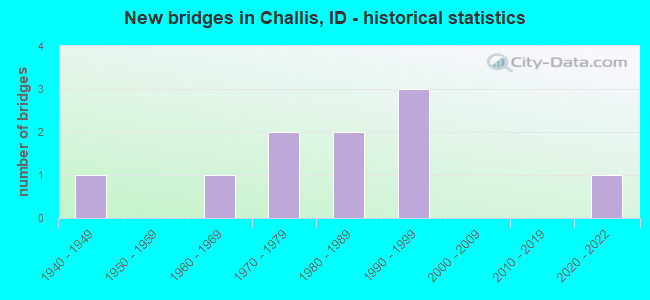
- New bridges - historical statistics
- 11940-1949
- 11960-1969
- 21970-1979
- 21980-1989
- 31990-1999
- 12020-2022

- Bridge Condition - Deck
- 10.0%Excellent
- 10.0%Very good
- 60.0%Good
- 10.0%Satisfactory
- 10.0%Fair

- Bridge Condition - Superstructure
- 10.0%Excellent
- 30.0%Very good
- 20.0%Good
- 30.0%Satisfactory
- 10.0%Fair

- Bridge Condition - Substructure
- 10.0%Excellent
- 60.0%Good
- 30.0%Satisfactory

- Bridge Condition - Channel
- 10.0%Excellent
- 10.0%Very good
- 50.0%Good
- 30.0%Satisfactory
Find on map >> Show street view
Structure Number: 1782, Location: 2.4 S. CHALLIS (Lat: 44.474278, Lng: -114.210750), Route carried "on" structure: State highway 75, Year Built: 1988, Status: Open, Structure Length: 0.64m (2.10ft), Average Daily Traffic: 770 (year 2019), Truck Traffic: 18%, Average Future Daily Traffic: 1,155 (year 2039), Design Load: HS 25 or greater, Features Intersected: GINI CANAL
Minimum Vertical Clearance: 30+ m (98+ ft), Kilometerpoint: 393.005, Lanes on structure: 2, Base Highway Network: Yes, Owner: State Highway Agency, Approaching Roadway Width: 10.4m (34.1ft), Skew: 3 degrees, Material/Design: Concrete, Design/Construction: Frame, Number Of Spans In Main Unit: 1, Length of Maximum Span: 6.4m (21.0ft), Curb or Sidewalk Widths: Left: 0.3m (1.0ft), Right: 0.3m (1.0ft), Curb-To-Curb Width: 25.0m (82.0ft), Out-to-Out Width: 25.6m (84.0ft)
Condition: Deck: Good, Superstructure: Good, Substructure: Good, Channel: Good, Operating Rating: 56.2 metric tons, Method Used To Determine Operating Rating: Load Factor (LF), Inventory Rating: 33.6 metric tons, Method Used To Determine Inventory Rating: Load Factor (LF), Structural Evaluation: Better than present minimum criteria, Deck Geometry: Superior to present desirable criteria, Waterway Adequacy: Equal to present desirable criteria, Approach Roadway Alignment: Equal to present desirable criteria, Designated Inspection Frequency: Every 48 months, Inspection Date: October 2019, Deck Structure Type: Concrete Cast-file-Place, Wearing Surface/Protective System: Wearing Surface: Bituminous, Membrane: Preformed Fabric
Find on map >> Show street view
Structure Number: 1784, Location: AT CHALLIS (Lat: 44.507917, Lng: -114.223444), Route carried "on" structure: US 93, Year Built: 1941, Status: Open, Structure Length: 0.64m (2.10ft), Average Daily Traffic: 2,100 (year 2019), Truck Traffic: 7%, Average Future Daily Traffic: 3,150 (year 2039), Design Load: H 15, Features Intersected: GARDEN CREEK
Minimum Vertical Clearance: 30+ m (98+ ft), Kilometerpoint: 397.082, Lanes on structure: 2, Base Highway Network: Yes (Inventory Route: US0, Subroute: 1), Owner: State Highway Agency, Approaching Roadway Width: 8.5m (27.9ft), Material/Design: Concrete, Design/Construction: Frame, Number Of Spans In Main Unit: 1, Length of Maximum Span: 6.4m (21.0ft), Curb-To-Curb Width: 13.1m (43.0ft), Out-to-Out Width: 13.7m (44.9ft)
Condition: Deck: Fair, Superstructure: Fair, Substructure: Satisfactory, Channel: Satisfactory, Operating Rating: 56.2 metric tons, Method Used To Determine Operating Rating: Load Factor (LF), Inventory Rating: 33.6 metric tons, Method Used To Determine Inventory Rating: Load Factor (LF), Structural Evaluation: Somewhat better than minimum adequacy, Deck Geometry: Equal to present minimum criteria, Waterway Adequacy: Equal to present minimum criteria, Approach Roadway Alignment: Equal to present minimum criteria, Length Of Structure Improvement: 1.31m (4.30ft), Designated Inspection Frequency: Every 24 months, Inspection Date: October 2020, Bridge Improvement Cost: $412,000, Roadway Improvement Cost: $41,000, Total Project Cost: $617,000 ( Estimate for 2020), Deck Structure Type: Concrete Cast-file-Place, Wearing Surface/Protective System: Wearing Surface: Bituminous
Find on map >> Show street view
Structure Number: 17846, Location: 4.8 N. CHALLIS (Lat: 44.569056, Lng: -114.193750), Route carried "on" structure: US 93, Year Built: 1991, Status: Open, Structure Length: 1.10m (3.61ft), Average Daily Traffic: 1,200 (year 2019), Truck Traffic: 15%, Average Future Daily Traffic: 1,800 (year 2039), Design Load: HS 25 or greater, Features Intersected: CHALLIS CREEK
Minimum Vertical Clearance: 30+ m (98+ ft), Kilometerpoint: 404.570, Lanes on structure: 2, Base Highway Network: Yes (Inventory Route: US0, Subroute: 1), Owner: State Highway Agency, Approaching Roadway Width: 9.8m (32.2ft), Skew: 1 degrees, Material/Design: Prestressed concrete, Design/Construction: Slab, Number Of Spans In Main Unit: 1, Length of Maximum Span: 10.7m (35.1ft), Curb-To-Curb Width: 9.8m (32.2ft), Out-to-Out Width: 11.0m (36.1ft)
Condition: Deck: Very good, Superstructure: Very good, Substructure: Good, Channel: Good, Operating Rating: 70.8 metric tons, Method Used To Determine Operating Rating: Load Factor (LF), Inventory Rating: 32.7 metric tons, Method Used To Determine Inventory Rating: Load Factor (LF), Structural Evaluation: Better than present minimum criteria, Deck Geometry: Somewhat better than minimum adequacy, Waterway Adequacy: Equal to present desirable criteria, Approach Roadway Alignment: Equal to present desirable criteria, Designated Inspection Frequency: Every 24 months, Inspection Date: October 2020, Deck Structure Type: Concrete Precast Panels, Wearing Surface/Protective System: Wearing Surface: Bituminous, Membrane: Preformed Fabric, Deck Protection: Epoxy Coated Reinforcing
Find on map >> Show street view
Structure Number: 18031, Location: 2.6 S. CHALLIS (Lat: 44.471361, Lng: -114.204056), Route carried "on" structure: US 93, Year Built: 1995, Status: Open, Structure Length: 9.33m (30.61ft), Average Daily Traffic: 1,000 (year 2019), Truck Traffic: 20%, Average Future Daily Traffic: 1,500 (year 2039), Design Load: HS 25 or greater, Features Intersected: SALMON RIVER;CHALLIS BR.
Minimum Vertical Clearance: 30+ m (98+ ft), Kilometerpoint: 257.536, Lanes on structure: 2, Base Highway Network: Yes (Inventory Route: US0, Subroute: 1), Owner: State Highway Agency, Approaching Roadway Width: 11.0m (36.1ft), Skew: 2 degrees, Material/Design: Steel continuous, Design/Construction: Stringer/Multi-beam, Number Of Spans In Main Unit: 2, Length of Maximum Span: 45.7m (149.9ft), Curb-To-Curb Width: 11.8m (38.7ft), Out-to-Out Width: 12.8m (42.0ft)
Condition: Deck: Good, Superstructure: Very good, Substructure: Good, Channel: Very good, Operating Rating: 68.9 metric tons, Method Used To Determine Operating Rating: Load Factor (LF), Inventory Rating: 40.8 metric tons, Method Used To Determine Inventory Rating: Load Factor (LF), Structural Evaluation: Better than present minimum criteria, Deck Geometry: Better than present minimum criteria, Waterway Adequacy: Equal to present desirable criteria, Approach Roadway Alignment: Equal to present desirable criteria, Designated Inspection Frequency: Every 48 months, Inspection Date: October 2020, Deck Structure Type: Concrete Cast-file-Place, Wearing Surface/Protective System: Wearing Surface: Epoxy Overlay, Deck Protection: Epoxy Coated Reinforcing
Find on map >> Show street view
Structure Number: 2265, Location: 2.0 S. 1.4 E. SHELLEY (Lat: 43.354722, Lng: -112.097333), Route carried "on" structure: County highway , Year Built: 1965, Year Reconstructed: 1984, Status: Open, Structure Length: 0.79m (2.59ft), Average Daily Traffic: 190 (year 2019), Truck Traffic: 10%, Average Future Daily Traffic: 285 (year 2039), Design Load: HS 20, Features Intersected: E.BR.SNAKE R.VALLEY CNL, Facility Carried by Structure: FOUNDRY RD;E 1100N
Minimum Vertical Clearance: 30+ m (98+ ft), Kilometerpoint: 166.466, Lanes on structure: 2, Owner: County Highway Agency, Approaching Roadway Width: 8.5m (27.9ft), Material/Design: Steel, Design/Construction: Stringer/Multi-beam, Number Of Spans In Main Unit: 1, Length of Maximum Span: 7.6m (24.9ft), Curb-To-Curb Width: 9.6m (31.5ft), Out-to-Out Width: 10.4m (34.1ft)
Condition: Deck: Good, Superstructure: Satisfactory, Substructure: Satisfactory, Channel: Good, Operating Rating: 59.9 metric tons, Method Used To Determine Operating Rating: Load Factor (LF), Inventory Rating: 35.4 metric tons, Method Used To Determine Inventory Rating: Load Factor (LF), Structural Evaluation: Equal to present minimum criteria, Deck Geometry: Equal to present minimum criteria, Waterway Adequacy: Better than present minimum criteria, Approach Roadway Alignment: Equal to present desirable criteria, Length Of Structure Improvement: 0.91m (2.99ft), Designated Inspection Frequency: Every 48 months, Inspection Date: October 2018, Bridge Improvement Cost: $150,000, Roadway Improvement Cost: $15,000, Total Project Cost: $225,000 ( Estimate for 2016), Deck Structure Type: Concrete Cast-file-Place, Wearing Surface/Protective System: Wearing Surface: Bituminous
Find on map >> Show street view
Structure Number: 22655, Location: 3.9 W. 2.0 S. STERLING (Lat: 43.009444, Lng: -112.802472), Route carried "on" structure: County highway , Year Built: 1970, Status: Open, Structure Length: 0.98m (3.22ft), Average Daily Traffic: 100 (year 2019), Truck Traffic: 10%, Average Future Daily Traffic: 150 (year 2039), Design Load: HS 20, Features Intersected: LOW LINE CANAL, Facility Carried by Structure: 1300 SOUTH ROAD
Minimum Vertical Clearance: 30+ m (98+ ft), Kilometerpoint: 168.487, Lanes on structure: 2, Owner: County Highway Agency, Approaching Roadway Width: 7.3m (24.0ft), Skew: 1 degrees, Material/Design: Prestressed concrete, Design/Construction: Tee Beam, Number Of Spans In Main Unit: 1, Length of Maximum Span: 9.4m (30.8ft), Curb or Sidewalk Widths: Left: 0.3m (1.0ft), Right: 0.3m (1.0ft), Curb-To-Curb Width: 8.5m (27.9ft), Out-to-Out Width: 9.1m (29.9ft)
Condition: Deck: Satisfactory, Superstructure: Satisfactory, Substructure: Good, Channel: Good, Operating Rating: 34.5 metric tons, Method Used To Determine Operating Rating: Field evaluation and documented engineering judgment, Inventory Rating: 20.9 metric tons, Method Used To Determine Inventory Rating: Field evaluation and documented engineering judgment, Structural Evaluation: Equal to present minimum criteria, Deck Geometry: Better than present minimum criteria, Waterway Adequacy: Better than present minimum criteria, Approach Roadway Alignment: Better than present minimum criteria, Designated Inspection Frequency: Every 24 months, Inspection Date: March 2020, Deck Structure Type: Concrete Cast-file-Place, Wearing Surface/Protective System: Wearing Surface: Monolithic Concrete
Find on map >> Show street view
Structure Number: 2843, Location: 11.5S 3.2E NEW PLYMOUTH (Lat: 43.807194, Lng: -116.756083), Route carried "on" structure: County highway , Year Built: 1975, Status: Open, Structure Length: 1.16m (3.81ft), Average Daily Traffic: 480 (year 2019), Truck Traffic: 15%, Average Future Daily Traffic: 720 (year 2039), Design Load: H 15, Features Intersected: 'D' LINE CANAL, Facility Carried by Structure: OASIS ROAD
Minimum Vertical Clearance: 30+ m (98+ ft), Kilometerpoint: 3.896, Lanes on structure: 2, Owner: County Highway Agency, Approaching Roadway Width: 7.3m (24.0ft), Skew: 2 degrees, Material/Design: Prestressed concrete, Design/Construction: Tee Beam, Number Of Spans In Main Unit: 1, Length of Maximum Span: 10.7m (35.1ft), Curb-To-Curb Width: 7.2m (23.6ft), Out-to-Out Width: 7.3m (24.0ft)
Condition: Deck: Good, Superstructure: Satisfactory, Substructure: Satisfactory, Channel: Good, Operating Rating: 34.5 metric tons, Method Used To Determine Operating Rating: Field evaluation and documented engineering judgment, Inventory Rating: 20.9 metric tons, Method Used To Determine Inventory Rating: Field evaluation and documented engineering judgment, Structural Evaluation: Equal to present minimum criteria, Deck Geometry: Meets minimum limits, Waterway Adequacy: Equal to present desirable criteria, Approach Roadway Alignment: Better than present minimum criteria, Length Of Structure Improvement: 1.83m (6.00ft), Designated Inspection Frequency: Every 24 months, Inspection Date: October 2020, Bridge Improvement Cost: $297,000, Roadway Improvement Cost: $30,000, Total Project Cost: $446,000, Deck Structure Type: Concrete Cast-file-Place, Wearing Surface/Protective System: Wearing Surface: Bituminous
Find on map >> Show street view
Structure Number: 31668, Location: 2.0 W. CHALLIS (Lat: 44.502167, Lng: -114.273722), Route carried "on" structure: County highway 6867, Year Built: 2020, Status: Open, Structure Length: 1.52m (4.99ft), Average Daily Traffic: 1,000 (year 2019), Average Future Daily Traffic: 1,500 (year 2039), Design Load: HL 93, Features Intersected: GARDEN CREEK
Minimum Vertical Clearance: 30+ m (98+ ft), Kilometerpoint: 66.014, Lanes on structure: 2, Owner: County Highway Agency, Approaching Roadway Width: 8.5m (27.9ft), Material/Design: Steel, Design/Construction: Stringer/Multi-beam, Number Of Spans In Main Unit: 1, Length of Maximum Span: 15.0m (49.2ft), Curb-To-Curb Width: 8.7m (28.5ft), Out-to-Out Width: 8.9m (29.2ft)
Condition: Deck: Excellent, Superstructure: Excellent, Substructure: Excellent, Channel: Excellent, Operating Rating: 42.4 metric tons, Method Used To Determine Operating Rating: Load and Resistance Factor Rating (LRFR) rating reported by rating factor(RF) method using HL-93 loadings, Inventory Rating: 32.7 metric tons, Method Used To Determine Inventory Rating: Load and Resistance Factor Rating (LRFR) rating reported by rating factor(RF) method using HL-93 loadings, Structural Evaluation: Superior to present desirable criteria, Deck Geometry: Somewhat better than minimum adequacy, Waterway Adequacy: Equal to present desirable criteria, Approach Roadway Alignment: Better than present minimum criteria, Designated Inspection Frequency: Every 24 months, Inspection Date: July 2020, Deck Structure Type: Corrugated Steel, Wearing Surface/Protective System: Wearing Surface: Bituminous
Find on map >> Show street view
Structure Number: 31761, Location: 3.8 N. 1.8 W. CHALLIS (Lat: 44.559472, Lng: -114.263750), Route carried "on" structure: County highway , Year Built: 1997, Status: Open, Structure Length: 0.73m (2.40ft), Average Daily Traffic: 80 (year 2019), Truck Traffic: 13%, Average Future Daily Traffic: 120 (year 2039), Design Load: HS 20, Features Intersected: CHALLIS CREEK, Facility Carried by Structure: CHALLIS CREEK RD
Minimum Vertical Clearance: 30+ m (98+ ft), Kilometerpoint: 169.292, Lanes on structure: 2, Owner: County Highway Agency, Approaching Roadway Width: 4.9m (16.1ft), Skew: 2 degrees, Material/Design: Concrete, Design/Construction: Frame, Number Of Spans In Main Unit: 1, Length of Maximum Span: 7.3m (24.0ft), Curb or Sidewalk Widths: Left: 0.3m (1.0ft), Right: 0.3m (1.0ft), Curb-To-Curb Width: 8.7m (28.5ft), Out-to-Out Width: 9.3m (30.5ft)
Condition: Deck: Good, Superstructure: Good, Substructure: Good, Channel: Satisfactory, Operating Rating: 44.5 metric tons, Method Used To Determine Operating Rating: Field evaluation and documented engineering judgment, Inventory Rating: 26.3 metric tons, Method Used To Determine Inventory Rating: Field evaluation and documented engineering judgment, Structural Evaluation: Equal to present minimum criteria, Deck Geometry: Better than present minimum criteria, Waterway Adequacy: Equal to present desirable criteria, Approach Roadway Alignment: Equal to present minimum criteria, Designated Inspection Frequency: Every 24 months, Inspection Date: July 2020, Deck Structure Type: Concrete Precast Panels, Wearing Surface/Protective System: Wearing Surface: Bituminous
Find on map >> Show street view
Structure Number: L59858, Location: 0.3 mi N of Challis Cr Rd (Lat: 44.561939, Lng: -114.259169), Route carried "on" structure: Federal lands road , Year Built: 1981, Status: Open, Structure Length: 1.33m (4.36ft), Average Daily Traffic: 25 (year 2011), Truck Traffic: 10%, Average Future Daily Traffic: 35 (year 2040), Design Load: HS 20, Features Intersected: Challis Creek, Facility Carried by Structure: 1920: DARLING CREE
Minimum Vertical Clearance: 30+ m (98+ ft), Kilometerpoint: 0.000, Lanes on structure: 1, Owner: Bureau of Land Management, Approaching Roadway Width: 4.3m (14.1ft), Skew: 3 degrees, Material/Design: Concrete, Design/Construction: Slab, Number Of Spans In Main Unit: 1, Length of Maximum Span: 12.3m (40.4ft), Curb or Sidewalk Widths: Left: 0.3m (1.0ft), Right: 0.3m (1.0ft), Curb-To-Curb Width: 4.3m (14.1ft), Out-to-Out Width: 4.9m (16.1ft)
Condition: Deck: Good, Superstructure: Very good, Substructure: Good, Channel: Satisfactory, Operating Rating: 38.6 metric tons, Method Used To Determine Operating Rating: Load and Resistance Factor Rating (LRFR) rating reported by rating factor(RF) method using HL-93 loadings, Inventory Rating: 29.8 metric tons, Method Used To Determine Inventory Rating: Load and Resistance Factor Rating (LRFR) rating reported by rating factor(RF) method using HL-93 loadings, Structural Evaluation: Better than present minimum criteria, Deck Geometry: Equal to present minimum criteria, Waterway Adequacy: Equal to present minimum criteria, Approach Roadway Alignment: Equal to present minimum criteria, Designated Inspection Frequency: Every 24 months, Inspection Date: August 2021, Deck Structure Type: Concrete Precast Panels, Wearing Surface/Protective System: Wearing Surface: Monolithic Concrete