Bridge Statistics for Chamberlayne, Virginia (VA)
Condition, Traffic, Stress, Structural Evaluation, Project Costs
- National Bridge Inventory (NBI) Statistics
- 18Number of bridges
- 292ft / 88.8mTotal length
- $3,279,000Total costs
- 651,930Total average daily traffic
- 51,887Total average daily truck traffic
- National Bridge Inventory (NBI) Registered Bridges for Chamberlayne
- No street view available for this location
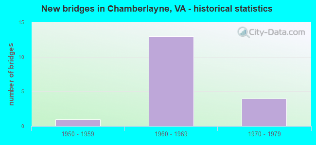
- New bridges - historical statistics
- 11950-1959
- 131960-1969
- 41970-1979

- Reconstructed bridges - Historical Statistics
- 21980-1989
- 01990-1999
- 42000-2009


- Bridge Condition - Deck
- 41.7%Good
- 41.7%Satisfactory
- 16.7%Fair

- Bridge Condition - Superstructure
- 25.0%Very good
- 8.3%Good
- 16.7%Satisfactory
- 50.0%Fair

- Bridge Condition - Substructure
- 33.3%Good
- 25.0%Satisfactory
- 41.7%Fair

- Bridge Condition - Channel
- 9.1%Very good
- 18.2%Good
- 54.5%Satisfactory
- 18.2%Fair
Find on map >> Show street view
Structure Number: 9448, Location: .0 HenricCo&.0Hanover Co (Lat: 37.653389, Lng: -77.431247), Route carried "on" structure: Interstate 295, Year Built: 1979, Status: Open, Structure Length: 12.89m (42.29ft), Average Daily Traffic: 43,066 (year 2020), Truck Traffic: 22%, Average Future Daily Traffic: 60,292 (year 2040), Design Load: HS 20+Mod, Features Intersected: CHICKAHOMINY RIVER
Minimum Vertical Clearance: 30+ m (98+ ft), Kilometerpoint: 17.007, Lanes on structure: 4, Base Highway Network: Yes, Owner: State Highway Agency, Approaching Roadway Width: 25.6m (84.0ft), Skew: 3 degrees, Material/Design: Steel continuous, Design/Construction: Stringer/Multi-beam, Number Of Spans In Main Unit: 3, Number Of Approach Spans: 2, Length of Maximum Span: 33.5m (109.9ft), Curb-To-Curb Width: 25.0m (82.0ft), Out-to-Out Width: 26.2m (86.0ft)
Condition: Deck: Satisfactory, Superstructure: Fair, Substructure: Fair, Channel: Satisfactory, Operating Rating: 82.6 metric tons, Method Used To Determine Operating Rating: Load and Resistance Factor (LRFR), Inventory Rating: 63.5 metric tons, Method Used To Determine Inventory Rating: Load and Resistance Factor (LRFR), Structural Evaluation: Somewhat better than minimum adequacy, Deck Geometry: Superior to present desirable criteria, Waterway Adequacy: Equal to present desirable criteria, Approach Roadway Alignment: Equal to present desirable criteria, Designated Inspection Frequency: Every 24 months, Inspection Date: January 2021, Deck Structure Type: Concrete Cast-file-Place, Wearing Surface/Protective System: Deck Protection: Epoxy Coated Reinforcing
Find on map >> Show street view
Structure Number: 9449, Location: 0.0FrHenrico&0.0ToHanover (Lat: 37.652631, Lng: -77.430825), Route carried "on" structure: Interstate 295, Year Built: 1979, Status: Open, Structure Length: 12.89m (42.29ft), Average Daily Traffic: 43,704 (year 2020), Average Future Daily Traffic: 61,186 (year 2040), Design Load: HS 20+Mod, Features Intersected: CHICKAHOMINY RIVER
Minimum Vertical Clearance: 30+ m (98+ ft), Kilometerpoint: 17.039, Lanes on structure: 5, Base Highway Network: Yes, Owner: State Highway Agency, Approaching Roadway Width: 25.6m (84.0ft), Skew: 3 degrees, Material/Design: Steel continuous, Design/Construction: Stringer/Multi-beam, Number Of Spans In Main Unit: 3, Number Of Approach Spans: 2, Length of Maximum Span: 33.5m (109.9ft), Curb-To-Curb Width: 25.0m (82.0ft), Out-to-Out Width: 26.2m (86.0ft)
Condition: Deck: Satisfactory, Superstructure: Fair, Substructure: Satisfactory, Channel: Good, Operating Rating: 73.5 metric tons, Method Used To Determine Operating Rating: Load and Resistance Factor (LRFR), Inventory Rating: 56.2 metric tons, Method Used To Determine Inventory Rating: Load and Resistance Factor (LRFR), Structural Evaluation: Somewhat better than minimum adequacy, Deck Geometry: Better than present minimum criteria, Waterway Adequacy: Equal to present desirable criteria, Approach Roadway Alignment: Equal to present desirable criteria, Designated Inspection Frequency: Every 24 months, Inspection Date: January 2021, Deck Structure Type: Concrete Cast-file-Place, Wearing Surface/Protective System: Deck Protection: Epoxy Coated Reinforcing
Find on map >> Show street view
Structure Number: 9462, Location: 0.0 HANOVE CO 0.0HENRIC C (Lat: 37.641411, Lng: -77.422033), Route carried "on" structure: US 301, Year Built: 1978, Status: Open, Structure Length: 9.22m (30.25ft), Average Daily Traffic: 13,978 (year 2020), Truck Traffic: 2%, Average Future Daily Traffic: 19,571 (year 2040), Design Load: HS 20+Mod, Features Intersected: CHICKAHOMINY RIVER, Facility Carried by Structure: SBL CHAMBERLAYNE
Minimum Vertical Clearance: 30+ m (98+ ft), Kilometerpoint: 133.085, Lanes on structure: 2, Base Highway Network: Yes, Owner: State Highway Agency, Approaching Roadway Width: 11.6m (38.1ft), Material/Design: Steel continuous, Design/Construction: Stringer/Multi-beam, Number Of Spans In Main Unit: 4, Length of Maximum Span: 26.5m (86.9ft), Curb-To-Curb Width: 11.6m (38.1ft), Out-to-Out Width: 12.8m (42.0ft)
Condition: Deck: Satisfactory, Superstructure: Satisfactory, Substructure: Satisfactory, Channel: Satisfactory, Operating Rating: 51.7 metric tons, Method Used To Determine Operating Rating: Load and Resistance Factor (LRFR), Inventory Rating: 38.1 metric tons, Method Used To Determine Inventory Rating: Load and Resistance Factor (LRFR), Structural Evaluation: Equal to present minimum criteria, Deck Geometry: Better than present minimum criteria, Waterway Adequacy: Equal to present desirable criteria, Approach Roadway Alignment: Equal to present desirable criteria, Designated Inspection Frequency: Every 24 months, Underwater Inspection Frequency: Every 60 months, Inspection Date: October 2021, Underwater Inspection Date: January 2021, Deck Structure Type: Concrete Cast-file-Place
Find on map >> Show street view
Structure Number: 9463, Location: 0.0 HANOVE CO 0.0HENRIC C (Lat: 37.641217, Lng: -77.421914), Route carried "on" structure: US 301, Year Built: 1978, Status: Open, Structure Length: 9.22m (30.25ft), Average Daily Traffic: 13,978 (year 2020), Truck Traffic: 1%, Average Future Daily Traffic: 19,571 (year 2040), Design Load: HS 20+Mod, Features Intersected: CHICKAHOMINY RIVER, Facility Carried by Structure: NBL CHAMBERLAYNE
Minimum Vertical Clearance: 30+ m (98+ ft), Kilometerpoint: 133.085, Lanes on structure: 2, Base Highway Network: Yes, Owner: State Highway Agency, Approaching Roadway Width: 11.6m (38.1ft), Material/Design: Steel continuous, Design/Construction: Stringer/Multi-beam, Number Of Spans In Main Unit: 4, Length of Maximum Span: 26.5m (86.9ft), Curb-To-Curb Width: 11.6m (38.1ft), Out-to-Out Width: 12.8m (42.0ft)
Condition: Deck: Good, Superstructure: Satisfactory, Substructure: Satisfactory, Channel: Satisfactory, Operating Rating: 45.4 metric tons, Method Used To Determine Operating Rating: Load and Resistance Factor (LRFR), Inventory Rating: 33.6 metric tons, Method Used To Determine Inventory Rating: Load and Resistance Factor (LRFR), Structural Evaluation: Equal to present minimum criteria, Deck Geometry: Better than present minimum criteria, Waterway Adequacy: Equal to present desirable criteria, Approach Roadway Alignment: Equal to present desirable criteria, Designated Inspection Frequency: Every 24 months, Underwater Inspection Frequency: Every 60 months, Inspection Date: October 2021, Underwater Inspection Date: January 2021, Deck Structure Type: Concrete Cast-file-Place, Wearing Surface/Protective System: Wearing Surface: Bituminous, Membrane: Epoxy
Find on map >> Show street view
Structure Number: 9603, Location: .6 FR 301 .33 TO UPHAM DR (Lat: 37.617389, Lng: -77.442456), Route carried "on" structure: ServiceCounty highway F653, Year Built: 1962, Status: Open, Structure Length: 3.29m (10.79ft), Average Daily Traffic: 782 (year 2020), Average Future Daily Traffic: 1,095 (year 2040), Design Load: H 20, Features Intersected: UPHAM BROOK, Facility Carried by Structure: ACCESS ROAD
Minimum Vertical Clearance: 30+ m (98+ ft), Kilometerpoint: 0.965, Lanes on structure: 2, Owner: County Highway Agency, Approaching Roadway Width: 6.4m (21.0ft), Material/Design: Steel, Design/Construction: Stringer/Multi-beam, Number Of Spans In Main Unit: 2, Length of Maximum Span: 16.5m (54.1ft), Curb-To-Curb Width: 6.1m (20.0ft), Out-to-Out Width: 7.0m (23.0ft)
Condition: Deck: Good, Superstructure: Very good, Substructure: Good, Channel: Good, Operating Rating: 42.1 metric tons, Method Used To Determine Operating Rating: Load and Resistance Factor (LRFR), Inventory Rating: 32.5 metric tons, Method Used To Determine Inventory Rating: Load and Resistance Factor (LRFR), Structural Evaluation: Better than present minimum criteria, Deck Geometry: High priority of corrective action, Waterway Adequacy: Equal to present desirable criteria, Approach Roadway Alignment: Equal to present desirable criteria, Length Of Structure Improvement: 3.29m (10.79ft), Designated Inspection Frequency: Every 24 months, Inspection Date: September 2020, Bridge Improvement Cost: $435,000, Roadway Improvement Cost: $140,000, Total Project Cost: $702,000, Deck Structure Type: Concrete Cast-file-Place
Find on map >> Show street view
Structure Number: 9661, Location: 0.72 N of Azalea Ave. (Lat: 37.613278, Lng: -77.424114), Route carried "on" structure: County highway 75940, Year Built: 1954, Year Reconstructed: 2008, Status: Open, Structure Length: 1.01m (3.31ft), Average Daily Traffic: 5,915 (year 2020), Truck Traffic: 4%, Average Future Daily Traffic: 6,506 (year 2040), Design Load: HS 20, Features Intersected: UPHAM BROOK, Facility Carried by Structure: WILKINSON ROAD
Minimum Vertical Clearance: 30+ m (98+ ft), Kilometerpoint: 4.047, Lanes on structure: 2, Owner: County Highway Agency, Approaching Roadway Width: 7.3m (24.0ft), Material/Design: Concrete, Design/Construction: Culvert, Number Of Spans In Main Unit: 3, Length of Maximum Span: 3.0m (9.8ft)
Condition: Channel: Fair, Culverts: Fair, Operating Rating: 39.8 metric tons, Method Used To Determine Operating Rating: Load Factor (LF), Inventory Rating: 23.9 metric tons, Method Used To Determine Inventory Rating: Load Factor (LF), Structural Evaluation: Somewhat better than minimum adequacy, Waterway Adequacy: Equal to present minimum criteria, Approach Roadway Alignment: Equal to present desirable criteria, Length Of Structure Improvement: 0.98m (3.22ft), Designated Inspection Frequency: Every 12 months, Inspection Date: May 2021, Bridge Improvement Cost: $945,000, Roadway Improvement Cost: $110,000, Total Project Cost: $1,372,000, Deck Structure Type: Concrete Cast-file-Place
Find on map >> Show street view
Structure Number: 9832, Location: 0.84 (301)SBL0.45 73 EBL (Lat: 37.629506, Lng: -77.449117), Route carried "on" structure: Interstate 95, Year Built: 1962, Status: Open, Structure Length: 4.05m (13.29ft), Average Daily Traffic: 44,010 (year 2020), Truck Traffic: 8%, Average Future Daily Traffic: 61,614 (year 2040), Design Load: HS 20+Mod, Features Intersected: WILKINSON ROAD
Minimum Vertical Clearance: 30+ m (98+ ft), Kilometerpoint: 133.434, Lanes on structure: 3, Lanes under structure: 2, Base Highway Network: Yes, Owner: State Highway Agency, Approaching Roadway Width: 16.4m (53.8ft), Skew: 2 degrees, Material/Design: Concrete, Design/Construction: Tee Beam, Number Of Spans In Main Unit: 3, Length of Maximum Span: 13.4m (44.0ft), Curb-To-Curb Width: 16.4m (53.8ft), Out-to-Out Width: 17.1m (56.1ft)
Condition: Deck: Satisfactory, Superstructure: Fair, Substructure: Fair, Operating Rating: 43.5 metric tons, Method Used To Determine Operating Rating: Load and Resistance Factor (LRFR), Inventory Rating: 31.8 metric tons, Method Used To Determine Inventory Rating: Load and Resistance Factor (LRFR), Structural Evaluation: Somewhat better than minimum adequacy, Deck Geometry: Equal to present minimum criteria, Underclear: High priority of corrective action, Approach Roadway Alignment: Equal to present desirable criteria, Designated Inspection Frequency: Every 24 months, Inspection Date: October 2020, Deck Structure Type: Concrete Cast-file-Place, Wearing Surface/Protective System: Wearing Surface: Bituminous, Membrane: Preformed Fabric
Find on map >> Show street view
Structure Number: 9834, Location: 0.84 (301)SBL0.45 73 EBL (Lat: 37.629514, Lng: -77.448836), Route carried "on" structure: Interstate 95, Year Built: 1962, Status: Open, Structure Length: 4.40m (14.44ft), Average Daily Traffic: 44,864 (year 2020), Truck Traffic: 8%, Average Future Daily Traffic: 62,810 (year 2040), Design Load: HS 20+Mod, Features Intersected: WILKINSON ROAD
Minimum Vertical Clearance: 30+ m (98+ ft), Kilometerpoint: 133.434, Lanes on structure: 3, Lanes under structure: 2, Base Highway Network: Yes, Owner: State Highway Agency, Approaching Roadway Width: 16.5m (54.1ft), Skew: 2 degrees, Material/Design: Concrete, Design/Construction: Tee Beam, Number Of Spans In Main Unit: 3, Length of Maximum Span: 14.3m (46.9ft), Curb-To-Curb Width: 16.5m (54.1ft), Out-to-Out Width: 17.1m (56.1ft)
Condition: Deck: Satisfactory, Superstructure: Fair, Substructure: Fair, Operating Rating: 39.0 metric tons, Method Used To Determine Operating Rating: Load and Resistance Factor (LRFR), Inventory Rating: 27.2 metric tons, Method Used To Determine Inventory Rating: Load and Resistance Factor (LRFR), Structural Evaluation: Somewhat better than minimum adequacy, Deck Geometry: Equal to present minimum criteria, Underclear: High priority of corrective action, Approach Roadway Alignment: Equal to present desirable criteria, Designated Inspection Frequency: Every 24 months, Inspection Date: October 2020, Deck Structure Type: Concrete Cast-file-Place, Wearing Surface/Protective System: Wearing Surface: Bituminous, Membrane: Preformed Fabric
Find on map >> Show street view
Structure Number: 9836, Location: 1.1 FR 1 / 1.29 TO 73 EBL (Lat: 37.618081, Lng: -77.444011), Route carried "on" structure: Interstate 95, Year Built: 1962, Year Reconstructed: 2014, Status: Open, Structure Length: 3.52m (11.55ft), Average Daily Traffic: 44,010 (year 2020), Truck Traffic: 8%, Average Future Daily Traffic: 61,614 (year 2040), Design Load: HS 20+Mod, Features Intersected: UPHAM BROOK
Minimum Vertical Clearance: 4.50m (14.76ft), Kilometerpoint: 132.131, Lanes on structure: 3, Base Highway Network: Yes, Owner: State Highway Agency, Approaching Roadway Width: 16.5m (54.1ft), Skew: 1 degrees, Material/Design: Steel continuous, Design/Construction: Stringer/Multi-beam, Number Of Spans In Main Unit: 3, Length of Maximum Span: 11.1m (36.4ft), Curb-To-Curb Width: 16.5m (54.1ft), Out-to-Out Width: 17.5m (57.4ft)
Condition: Deck: Good, Superstructure: Good, Substructure: Good, Channel: Satisfactory, Operating Rating: 90.0 metric tons, Method Used To Determine Operating Rating: Load and Resistance Factor (LRFR), Inventory Rating: 69.4 metric tons, Method Used To Determine Inventory Rating: Load and Resistance Factor (LRFR), Structural Evaluation: Better than present minimum criteria, Deck Geometry: High priority of corrective action, Waterway Adequacy: Equal to present desirable criteria, Approach Roadway Alignment: Equal to present desirable criteria, Length Of Structure Improvement: 3.51m (11.52ft), Designated Inspection Frequency: Every 24 months, Inspection Date: September 2020, Bridge Improvement Cost: $75,000, Roadway Improvement Cost: $1,000, Total Project Cost: $85,000, Deck Structure Type: Concrete Precast Panels, Wearing Surface/Protective System: Deck Protection: Epoxy Coated Reinforcing
Find on map >> Show street view
Structure Number: 9837, Location: 1.1 FR 1 / 1.29 TO 73 EBL (Lat: 37.618033, Lng: -77.443786), Route carried "on" structure: Interstate 95, Year Built: 1962, Year Reconstructed: 2014, Status: Open, Structure Length: 3.51m (11.52ft), Average Daily Traffic: 44,864 (year 2020), Truck Traffic: 8%, Average Future Daily Traffic: 62,810 (year 2040), Design Load: HS 20+Mod, Features Intersected: UPHAM BROOK
Minimum Vertical Clearance: 4.70m (15.42ft), Kilometerpoint: 132.099, Lanes on structure: 3, Base Highway Network: Yes, Owner: State Highway Agency, Approaching Roadway Width: 16.5m (54.1ft), Skew: 1 degrees, Material/Design: Steel continuous, Design/Construction: Stringer/Multi-beam, Number Of Spans In Main Unit: 3, Length of Maximum Span: 11.1m (36.4ft), Curb-To-Curb Width: 16.5m (54.1ft), Out-to-Out Width: 17.5m (57.4ft)
Condition: Deck: Good, Superstructure: Very good, Substructure: Good, Channel: Satisfactory, Operating Rating: 90.0 metric tons, Method Used To Determine Operating Rating: Load and Resistance Factor (LRFR), Inventory Rating: 69.4 metric tons, Method Used To Determine Inventory Rating: Load and Resistance Factor (LRFR), Structural Evaluation: Better than present minimum criteria, Deck Geometry: Meets minimum limits, Waterway Adequacy: Equal to present desirable criteria, Approach Roadway Alignment: Equal to present desirable criteria, Designated Inspection Frequency: Every 24 months, Inspection Date: September 2020, Deck Structure Type: Concrete Precast Panels, Wearing Surface/Protective System: Deck Protection: Epoxy Coated Reinforcing
Find on map >> Show street view
Structure Number: 9845, Location: .60 TO 2(301) 7 1.10 TO73 (Lat: 37.621058, Lng: -77.444306), Route carried "on" structure: Interstate 95, Year Built: 1962, Status: Open, Structure Length: 0.82m (2.69ft), Average Daily Traffic: 88,874 (year 2020), Truck Traffic: 8%, Average Future Daily Traffic: 114,969 (year 2040), Design Load: HS 20, Features Intersected: FLIPPEN CREEK
Minimum Vertical Clearance: 30+ m (98+ ft), Kilometerpoint: 132.421, Lanes on structure: 6, Base Highway Network: Yes, Owner: State Highway Agency, Approaching Roadway Width: 33.5m (109.9ft), Skew: 24 degrees, Material/Design: Concrete, Design/Construction: Culvert, Number Of Spans In Main Unit: 3, Length of Maximum Span: 2.4m (7.9ft)
Condition: Channel: Fair, Culverts: Fair, Operating Rating: 89.8 metric tons, Method Used To Determine Operating Rating: Field evaluation and documented engineering judgment, Inventory Rating: 89.8 metric tons, Method Used To Determine Inventory Rating: Field evaluation and documented engineering judgment, Structural Evaluation: Somewhat better than minimum adequacy, Waterway Adequacy: Equal to present desirable criteria, Approach Roadway Alignment: Equal to present desirable criteria, Designated Inspection Frequency: Every 24 months, Inspection Date: October 2020
Find on map >> Show street view
Structure Number: 10008, Location: 0.44 TO I-95 & 0.71 NCL R (Lat: 37.611392, Lng: -77.447006), Route carried "on" structure: Alternate US 301, Year Built: 1962, Year Reconstructed: 1992, Status: Open, Structure Length: 11.51m (37.76ft), Average Daily Traffic: 12,000 (year 2019), Truck Traffic: 3%, Average Future Daily Traffic: 14,300 (year 2034), Design Load: HS 20+Mod, Features Intersected: RTE I 95, Facility Carried by Structure: SBL CHAMBERLAYNE
Minimum Vertical Clearance: 30+ m (98+ ft), Kilometerpoint: 131.327, Lanes on structure: 2, Lanes under structure: 6, Base Highway Network: Yes, Owner: State Highway Agency, Approaching Roadway Width: 8.8m (28.9ft), Skew: 5 degrees, Material/Design: Steel, Design/Construction: Stringer/Multi-beam, Number Of Spans In Main Unit: 4, Length of Maximum Span: 36.0m (118.1ft), Curb or Sidewalk Widths: Left: 0.5m (1.6ft), Right: 0.5m (1.6ft), Curb-To-Curb Width: 8.5m (27.9ft), Out-to-Out Width: 9.4m (30.8ft)
Condition: Deck: Fair, Superstructure: Fair, Substructure: Fair, Operating Rating: 62.6 metric tons, Method Used To Determine Operating Rating: Load and Resistance Factor (LRFR), Inventory Rating: 48.1 metric tons, Method Used To Determine Inventory Rating: Load and Resistance Factor (LRFR), Structural Evaluation: Somewhat better than minimum adequacy, Deck Geometry: High priority of corrective action, Underclear: High priority of corrective action, Approach Roadway Alignment: Equal to present minimum criteria, Length Of Structure Improvement: 11.49m (37.70ft), Designated Inspection Frequency: Every 24 months, Inspection Date: January 2021, Bridge Improvement Cost: $200,000, Roadway Improvement Cost: $50,000, Total Project Cost: $300,000, Deck Structure Type: Concrete Cast-file-Place, Wearing Surface/Protective System: Wearing Surface: Latex Concrete
Find on map >> Show street view
Structure Number: 1001, Location: 0.88WILKSN RD0.44I-95 (Lat: 37.617933, Lng: -77.444311), Route carried "on" structure: US 301, Year Built: 1962, Year Reconstructed: 1992, Status: Open, Structure Length: 9.21m (30.22ft), Average Daily Traffic: 14,000 (year 2017), Truck Traffic: 2%, Average Future Daily Traffic: 18,000 (year 2035), Design Load: HS 20+Mod, Features Intersected: RTE I 95 & UPHAM BROOK, Facility Carried by Structure: SBL CHAMBERLAYNE
Minimum Vertical Clearance: 30+ m (98+ ft), Kilometerpoint: 129.787, Lanes on structure: 3, Lanes under structure: 6, Base Highway Network: Yes, Owner: State Highway Agency, Approaching Roadway Width: 14.6m (47.9ft), Skew: 4 degrees, Material/Design: Steel, Design/Construction: Stringer/Multi-beam, Number Of Spans In Main Unit: 4, Length of Maximum Span: 27.4m (89.9ft), Curb or Sidewalk Widths: Left: 0.5m (1.6ft), Right: 0.5m (1.6ft), Curb-To-Curb Width: 12.2m (40.0ft), Out-to-Out Width: 13.1m (43.0ft)
Condition: Deck: Fair, Superstructure: Fair, Substructure: Fair, Channel: Satisfactory, Operating Rating: 62.6 metric tons, Method Used To Determine Operating Rating: Load and Resistance Factor (LRFR), Inventory Rating: 48.1 metric tons, Method Used To Determine Inventory Rating: Load and Resistance Factor (LRFR), Structural Evaluation: Somewhat better than minimum adequacy, Deck Geometry: Meets minimum limits, Underclear: High priority of corrective action, Approach Roadway Alignment: Equal to present minimum criteria, Length Of Structure Improvement: 9.20m (30.18ft), Designated Inspection Frequency: Every 24 months, Inspection Date: January 2021, Bridge Improvement Cost: $200,000, Roadway Improvement Cost: $50,000, Total Project Cost: $300,000, Deck Structure Type: Concrete Cast-file-Place, Wearing Surface/Protective System: Wearing Surface: Latex Concrete
Find on map >> Show street view
Structure Number: 10012, Location: 1.37FR WILMR&0.32TO UPHM (Lat: 37.617367, Lng: -77.442617), Route carried "on" structure: US 301, Year Built: 1962, Year Reconstructed: 2012, Status: Open, Structure Length: 3.31m (10.86ft), Average Daily Traffic: 4,885 (year 2020), Truck Traffic: 2%, Average Future Daily Traffic: 6,839 (year 2040), Design Load: HS 20+Mod, Features Intersected: UPHAM BROOK, Facility Carried by Structure: NBL CHAMBERLAYNE
Minimum Vertical Clearance: 30+ m (98+ ft), Kilometerpoint: 129.814, Lanes on structure: 3, Base Highway Network: Yes, Owner: State Highway Agency, Approaching Roadway Width: 12.1m (39.7ft), Material/Design: Steel continuous, Design/Construction: Stringer/Multi-beam, Number Of Spans In Main Unit: 2, Length of Maximum Span: 16.2m (53.1ft), Curb-To-Curb Width: 11.6m (38.1ft), Out-to-Out Width: 12.1m (39.7ft)
Condition: Deck: Good, Superstructure: Very good, Substructure: Good, Channel: Very good, Operating Rating: 76.6 metric tons, Method Used To Determine Operating Rating: Load and Resistance Factor (LRFR), Inventory Rating: 59.1 metric tons, Method Used To Determine Inventory Rating: Load and Resistance Factor (LRFR), Structural Evaluation: Better than present minimum criteria, Deck Geometry: High priority of replacement, Waterway Adequacy: Better than present minimum criteria, Approach Roadway Alignment: Equal to present desirable criteria, Length Of Structure Improvement: 3.29m (10.79ft), Designated Inspection Frequency: Every 24 months, Inspection Date: August 2021, Bridge Improvement Cost: $360,000, Roadway Improvement Cost: $85,000, Total Project Cost: $520,000, Deck Structure Type: Concrete Cast-file-Place, Wearing Surface/Protective System: Deck Protection: Other Coated Reinforcing
Find on map >> Show street view
Structure Number: 9832, Location: 0.84 (301)SBL0.45 73 EBL (Lat: 37.629506, Lng: -77.449117), Route carried "under" structure: County highway , Year Built: 1962, Structure Length: 0. m, Average Daily Traffic: 8,500 (year 2017), Truck Traffic: 2%, Features Intersected: WILKINSON ROAD, Facility Carried by Structure: SBL I-95
Minimum Vertical Clearance: 4.75m (15.58ft), Kilometerpoint: 0.805, Lanes on structure: 3, Lanes under structure: 2, Material/Design: Concrete, Design/Construction: Tee Beam, Length of Maximum Span: 13.4m (44.0ft)
Find on map >> Show street view
Structure Number: 9834, Location: 0.84 (301)SBL0.45 73 EBL (Lat: 37.629514, Lng: -77.448836), Route carried "under" structure: County highway , Year Built: 1962, Structure Length: 0. m, Average Daily Traffic: 8,500 (year 2017), Truck Traffic: 1%, Features Intersected: WILKINSON ROAD, Facility Carried by Structure: NBL I-95
Minimum Vertical Clearance: 6.43m (21.10ft), Kilometerpoint: 0.805, Lanes on structure: 3, Lanes under structure: 2, Material/Design: Concrete, Design/Construction: Tee Beam, Length of Maximum Span: 14.3m (46.9ft)
Find on map >> Show street view
Structure Number: 10008, Location: 0.44 TO I-95 & 0.71 NCL R (Lat: 37.611392, Lng: -77.447006), Route carried "under" structure: Interstate 95, Year Built: 1962, Structure Length: 0. m, Average Daily Traffic: 108,000 (year 2019), Truck Traffic: 9%, Features Intersected: RTE I 95, Facility Carried by Structure: SBL CHAMBERLAYNE
Minimum Vertical Clearance: 4.72m (15.49ft), Kilometerpoint: 131.327, Lanes on structure: 2, Lanes under structure: 6, Material/Design: Steel, Design/Construction: Stringer/Multi-beam, Length of Maximum Span: 36.0m (118.1ft)
Find on map >> Show street view
Structure Number: 1001, Location: 0.88WILKSN RD0.44I-95 (Lat: 37.617933, Lng: -77.444311), Route carried "under" structure: Interstate 95, Year Built: 1962, Structure Length: 0. m, Average Daily Traffic: 108,000 (year 2017), Truck Traffic: 9%, Features Intersected: RTE I 95 & UPHAM BROOK, Facility Carried by Structure: SBL CHAMBERLAYNE
Minimum Vertical Clearance: 4.70m (15.42ft), Kilometerpoint: 132.147, Lanes on structure: 3, Lanes under structure: 6, Material/Design: Steel, Design/Construction: Stringer/Multi-beam, Length of Maximum Span: 27.4m (89.9ft)