Bridge Statistics for Champlain, New York (NY)
Condition, Traffic, Stress, Structural Evaluation, Project Costs
- National Bridge Inventory (NBI) Statistics
- 16Number of bridges
- 243ft / 73.8mTotal length
- $32,864,000Total costs
- 25,078Total average daily traffic
- 3,965Total average daily truck traffic
- National Bridge Inventory (NBI) Registered Bridges for Champlain
- No street view available for this location
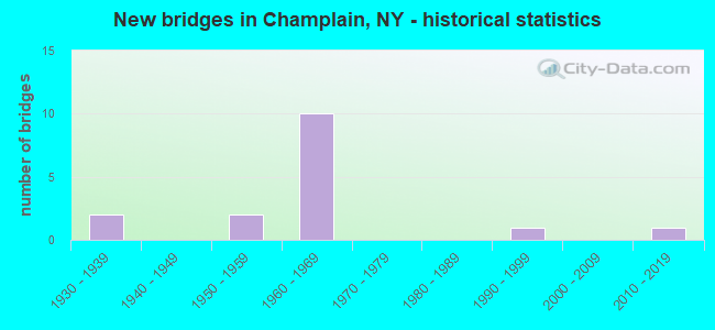
- New bridges - historical statistics
- 21930-1939
- 21950-1959
- 101960-1969
- 11990-1999
- 12010-2019

- Reconstructed bridges - Historical Statistics
- 11970-1979
- 21980-1989
- 11990-1999


- Bridge Condition - Deck
- 30.0%Good
- 30.0%Satisfactory
- 30.0%Fair
- 10.0%Poor

- Bridge Condition - Superstructure
- 30.0%Good
- 40.0%Satisfactory
- 20.0%Fair
- 10.0%Poor

- Bridge Condition - Substructure
- 50.0%Good
- 20.0%Satisfactory
- 30.0%Fair

- Bridge Condition - Channel
- 57.1%Very good
- 42.9%Good
Find on map >> Show street view
Structure Number: 100606, Location: IN CHAMPLAIN (Lat: 44.987092, Lng: -73.449061), Route carried "on" structure: US 9, Year Built: 1932, Year Reconstructed: 1984, Status: Open, Structure Length: 3.84m (12.60ft), Average Daily Traffic: 1,734 (year 2020), Truck Traffic: 12%, Average Future Daily Traffic: 1,808 (year 2040), Design Load: HS 20, Features Intersected: GREAT CHAZY RIVER
Minimum Vertical Clearance: 30+ m (98+ ft), Kilometerpoint: 52.550, Lanes on structure: 2, Base Highway Network: Yes, Owner: State Highway Agency, Approaching Roadway Width: 7.3m (24.0ft), Material/Design: Steel, Design/Construction: Truss - Thru, Number Of Spans In Main Unit: 1, Length of Maximum Span: 36.6m (120.1ft), Curb or Sidewalk Widths: Left: 0.0m, Right: 1.5m (4.9ft), Curb-To-Curb Width: 7.3m (24.0ft), Out-to-Out Width: 8.0m (26.2ft)
Condition: Deck: Satisfactory, Superstructure: Poor, Substructure: Good, Channel: Very good, Operating Rating: 56.2 metric tons, Method Used To Determine Operating Rating: Load Factor (LF), Inventory Rating: 33.6 metric tons, Method Used To Determine Inventory Rating: Load Factor (LF), Structural Evaluation: Meets minimum limits, Deck Geometry: Meets minimum limits, Waterway Adequacy: Equal to present minimum criteria, Approach Roadway Alignment: Meets minimum limits, Length Of Structure Improvement: 3.83m (12.57ft), Designated Inspection Frequency: Every 24 months, Critical Feature Inspection Frequency: Every 24 months, Inspection Date: June 2021, Critical Feature Inspection Date: June 2021, Bridge Improvement Cost: $2,434,000, Roadway Improvement Cost: $1,425,000, Total Project Cost: $3,860,000 ( Estimate for 2021), Deck Structure Type: Concrete Cast-file-Place, Wearing Surface/Protective System: Wearing Surface: Integral Concrete, Deck Protection: Epoxy Coated Reinforcing
Find on map >> Show street view
Structure Number: 100908, Location: 0.5 MI E JCT 11 + 9 (Lat: 44.979931, Lng: -73.433503), Route carried "on" structure: US 11, Year Built: 1961, Status: Open, Structure Length: 5.61m (18.41ft), Average Daily Traffic: 5,503 (year 2020), Truck Traffic: 14%, Average Future Daily Traffic: 5,555 (year 2040), Design Load: HS 20, Features Intersected: GREAT CHAZY RIVER
Minimum Vertical Clearance: 30+ m (98+ ft), Kilometerpoint: 51.456, Lanes on structure: 2, Base Highway Network: Yes, Owner: State Highway Agency, Approaching Roadway Width: 11.0m (36.1ft), Material/Design: Steel, Design/Construction: Stringer/Multi-beam, Number Of Spans In Main Unit: 2, Length of Maximum Span: 26.8m (87.9ft), Curb or Sidewalk Widths: Left: 0.5m (1.6ft), Right: 0.5m (1.6ft), Curb-To-Curb Width: 8.5m (27.9ft), Out-to-Out Width: 10.1m (33.1ft)
Condition: Deck: Good, Superstructure: Good, Substructure: Good, Channel: Very good, Operating Rating: 80.7 metric tons, Method Used To Determine Operating Rating: Load Factor (LF), Inventory Rating: 48.1 metric tons, Method Used To Determine Inventory Rating: Load Factor (LF), Structural Evaluation: Better than present minimum criteria, Deck Geometry: High priority of replacement, Waterway Adequacy: Equal to present minimum criteria, Approach Roadway Alignment: Meets minimum limits, Length Of Structure Improvement: 5.60m (18.37ft), Designated Inspection Frequency: Every 24 months, Underwater Inspection Frequency: Every 60 months, Inspection Date: June 2021, Underwater Inspection Date: September 2017, Bridge Improvement Cost: $1,121,000, Roadway Improvement Cost: $657,000, Total Project Cost: $1,778,000 ( Estimate for 2021), Deck Structure Type: Concrete Cast-file-Place, Wearing Surface/Protective System: Wearing Surface: Bituminous
Find on map >> Show street view
Structure Number: 103414, Location: .6 MI S JCT I87 & US11 (Lat: 44.972867, Lng: -73.452950), Route carried "on" structure: County highway , Year Built: 1958, Status: Open, Structure Length: 9.81m (32.19ft), Average Daily Traffic: 661 (year 2017), Truck Traffic: 3%, Average Future Daily Traffic: 925 (year 2037), Design Load: HS 20, Features Intersected: RTE I87, RTE I87, Facility Carried by Structure: CR19 (RIDGE RD)
Minimum Vertical Clearance: 30+ m (98+ ft), Kilometerpoint: 4.875, Lanes on structure: 2, Lanes under structure: 4, Owner: State Highway Agency, Approaching Roadway Width: 9.1m (29.9ft), Skew: 4 degrees, Material/Design: Steel, Design/Construction: Stringer/Multi-beam, Number Of Spans In Main Unit: 4, Length of Maximum Span: 31.4m (103.0ft), Curb or Sidewalk Widths: Left: 0.5m (1.6ft), Right: 0.5m (1.6ft), Curb-To-Curb Width: 9.1m (29.9ft), Out-to-Out Width: 10.8m (35.4ft)
Condition: Deck: Satisfactory, Superstructure: Satisfactory, Substructure: Good, Operating Rating: 64.4 metric tons, Method Used To Determine Operating Rating: Load Factor (LF), Inventory Rating: 38.1 metric tons, Method Used To Determine Inventory Rating: Load Factor (LF), Structural Evaluation: Equal to present minimum criteria, Deck Geometry: Equal to present minimum criteria, Underclear: High priority of corrective action, Approach Roadway Alignment: Equal to present desirable criteria, Length Of Structure Improvement: 9.81m (32.19ft), Designated Inspection Frequency: Every 24 months, Inspection Date: September 2021, Bridge Improvement Cost: $1,939,000, Roadway Improvement Cost: $1,136,000, Total Project Cost: $3,075,000 ( Estimate for 2021), Deck Structure Type: Concrete Cast-file-Place, Wearing Surface/Protective System: Wearing Surface: Bituminous, Membrane: Other
Find on map >> Show street view
Structure Number: 1034151, Location: JCT RTE I-87 + GR CHAZY R (Lat: 44.987058, Lng: -73.457644), Route carried "on" structure: Interstate 87, Year Built: 1960, Status: Open, Structure Length: 8.35m (27.40ft), Average Daily Traffic: 3,281 (year 2012), Truck Traffic: 28%, Design Load: HS 20, Features Intersected: GREAT CHAZY RIVER
Minimum Vertical Clearance: 30+ m (98+ ft), Kilometerpoint: 58.358, Lanes on structure: 2, Base Highway Network: Yes, Owner: State Highway Agency, Approaching Roadway Width: 12.8m (42.0ft), Skew: 1 degrees, Material/Design: Steel, Design/Construction: Stringer/Multi-beam, Number Of Spans In Main Unit: 3, Length of Maximum Span: 36.6m (120.1ft), Curb-To-Curb Width: 12.8m (42.0ft), Out-to-Out Width: 14.4m (47.2ft)
Condition: Deck: Fair, Superstructure: Satisfactory, Substructure: Satisfactory, Channel: Very good, Operating Rating: 54.4 metric tons, Method Used To Determine Operating Rating: Load Factor (LF), Inventory Rating: 32.7 metric tons, Method Used To Determine Inventory Rating: Load Factor (LF), Structural Evaluation: Equal to present minimum criteria, Deck Geometry: Equal to present desirable criteria, Waterway Adequacy: Equal to present minimum criteria, Approach Roadway Alignment: Equal to present desirable criteria, Length Of Structure Improvement: 8.35m (27.40ft), Designated Inspection Frequency: Every 24 months, Inspection Date: May 2020, Bridge Improvement Cost: $2,186,000, Roadway Improvement Cost: $1,280,000, Total Project Cost: $3,467,000 ( Estimate for 2021), Deck Structure Type: Concrete Cast-file-Place, Wearing Surface/Protective System: Wearing Surface: Integral Concrete
Find on map >> Show street view
Structure Number: 1034152, Location: JCT RTE I-87 + GR CHAZY R (Lat: 44.987022, Lng: -73.457319), Route carried "on" structure: Interstate 87, Year Built: 1960, Status: Open, Structure Length: 8.35m (27.40ft), Average Daily Traffic: 1,484 (year 2020), Truck Traffic: 34%, Average Future Daily Traffic: 1,767 (year 2040), Design Load: HS 20, Features Intersected: GREAT CHAZY RIVER
Minimum Vertical Clearance: 30+ m (98+ ft), Kilometerpoint: 58.358, Lanes on structure: 2, Base Highway Network: Yes, Owner: State Highway Agency, Approaching Roadway Width: 11.0m (36.1ft), Skew: 1 degrees, Material/Design: Steel, Design/Construction: Stringer/Multi-beam, Number Of Spans In Main Unit: 3, Length of Maximum Span: 36.6m (120.1ft), Curb-To-Curb Width: 12.8m (42.0ft), Out-to-Out Width: 14.4m (47.2ft)
Condition: Deck: Fair, Superstructure: Satisfactory, Substructure: Satisfactory, Channel: Very good, Operating Rating: 59.9 metric tons, Method Used To Determine Operating Rating: Load Factor (LF), Inventory Rating: 35.4 metric tons, Method Used To Determine Inventory Rating: Load Factor (LF), Structural Evaluation: Equal to present minimum criteria, Deck Geometry: Equal to present desirable criteria, Waterway Adequacy: Equal to present minimum criteria, Approach Roadway Alignment: Equal to present desirable criteria, Length Of Structure Improvement: 8.35m (27.40ft), Designated Inspection Frequency: Every 24 months, Inspection Date: May 2020, Bridge Improvement Cost: $2,186,000, Roadway Improvement Cost: $1,280,000, Total Project Cost: $3,467,000 ( Estimate for 2021), Deck Structure Type: Concrete Cast-file-Place, Wearing Surface/Protective System: Wearing Surface: Integral Concrete
Find on map >> Show street view
Structure Number: 1034161, Location: 0.8 MI N JCT RTS I-87 +11 (Lat: 44.991161, Lng: -73.456869), Route carried "on" structure: Interstate 87, Year Built: 1960, Year Reconstructed: 1991, Status: Open, Structure Length: 13.99m (45.90ft), Average Daily Traffic: 3,281 (year 2012), Truck Traffic: 28%, Design Load: HS 20, Features Intersected: RTE 9, ABAND.RUTLAND RR,
Minimum Vertical Clearance: 30+ m (98+ ft), Kilometerpoint: 58.632, Lanes on structure: 2, Lanes under structure: 4, Base Highway Network: Yes, Owner: State Highway Agency, Approaching Roadway Width: 11.0m (36.1ft), Material/Design: Steel, Design/Construction: Stringer/Multi-beam, Number Of Spans In Main Unit: 8, Length of Maximum Span: 18.9m (62.0ft), Curb-To-Curb Width: 12.8m (42.0ft), Out-to-Out Width: 13.8m (45.3ft)
Condition: Deck: Good, Superstructure: Good, Substructure: Fair, Operating Rating: 63.5 metric tons, Method Used To Determine Operating Rating: Load Factor (LF), Inventory Rating: 33.6 metric tons, Method Used To Determine Inventory Rating: Load Factor (LF), Structural Evaluation: Somewhat better than minimum adequacy, Deck Geometry: Equal to present desirable criteria, Underclear: High priority of corrective action, Approach Roadway Alignment: Equal to present desirable criteria, Length Of Structure Improvement: 13.99m (45.90ft), Designated Inspection Frequency: Every 24 months, Inspection Date: September 2021, Bridge Improvement Cost: $3,397,000, Roadway Improvement Cost: $1,989,000, Total Project Cost: $5,387,000 ( Estimate for 2021), Deck Structure Type: Concrete Cast-file-Place, Wearing Surface/Protective System: Wearing Surface: Integral Concrete, Deck Protection: Epoxy Coated Reinforcing
Find on map >> Show street view
Structure Number: 1034162, Location: 0.8 MI N JCT RTS I-87 +11 (Lat: 44.991103, Lng: -73.456561), Route carried "on" structure: Interstate 87, Year Built: 1960, Year Reconstructed: 1991, Status: Open, Structure Length: 13.99m (45.90ft), Average Daily Traffic: 1,484 (year 2020), Truck Traffic: 34%, Average Future Daily Traffic: 1,767 (year 2040), Design Load: HS 20, Features Intersected: RTE 9, ABOND.RUTLAND RR,
Minimum Vertical Clearance: 30+ m (98+ ft), Kilometerpoint: 58.825, Lanes on structure: 2, Lanes under structure: 4, Base Highway Network: Yes, Owner: State Highway Agency, Approaching Roadway Width: 11.0m (36.1ft), Material/Design: Steel, Design/Construction: Stringer/Multi-beam, Number Of Spans In Main Unit: 8, Length of Maximum Span: 18.9m (62.0ft), Curb-To-Curb Width: 12.8m (42.0ft), Out-to-Out Width: 13.8m (45.3ft)
Condition: Deck: Good, Superstructure: Good, Substructure: Fair, Operating Rating: 63.5 metric tons, Method Used To Determine Operating Rating: Load Factor (LF), Inventory Rating: 33.6 metric tons, Method Used To Determine Inventory Rating: Load Factor (LF), Structural Evaluation: Somewhat better than minimum adequacy, Deck Geometry: Equal to present desirable criteria, Underclear: High priority of corrective action, Approach Roadway Alignment: Equal to present desirable criteria, Length Of Structure Improvement: 13.99m (45.90ft), Designated Inspection Frequency: Every 24 months, Inspection Date: September 2021, Bridge Improvement Cost: $3,383,000, Roadway Improvement Cost: $1,981,000, Total Project Cost: $5,364,000 ( Estimate for 2021), Deck Structure Type: Concrete Cast-file-Place, Wearing Surface/Protective System: Wearing Surface: Integral Concrete, Deck Protection: Epoxy Coated Reinforcing
Find on map >> Show street view
Structure Number: 33362, Location: 1 MI N JCT US 11 & I87 (Lat: 44.987314, Lng: -73.459797), Route carried "on" structure: Other road , Year Built: 1991, Status: Posted for load, Structure Length: 3.78m (12.40ft), Average Daily Traffic: 203 (year 2015), Truck Traffic: 4%, Average Future Daily Traffic: 284 (year 2035), Design Load: HS 20, Features Intersected: GREAT CHAZY RIVER, Facility Carried by Structure: DUBOIS - WEBB RD
Minimum Vertical Clearance: 30+ m (98+ ft), Kilometerpoint: 4.634, Lanes on structure: 2, Owner: County Highway Agency, Approaching Roadway Width: 7.3m (24.0ft), Material/Design: Steel, Design/Construction: Truss - Thru, Number Of Spans In Main Unit: 1, Length of Maximum Span: 36.5m (119.8ft), Curb-To-Curb Width: 7.3m (24.0ft), Out-to-Out Width: 7.8m (25.6ft)
Condition: Deck: Poor, Superstructure: Fair, Substructure: Good, Channel: Good, Operating Rating: 23.6 metric tons, Method Used To Determine Operating Rating: Load Factor (LF), Inventory Rating: 13.6 metric tons, Method Used To Determine Inventory Rating: Load Factor (LF), Structural Evaluation: Meets minimum limits, Deck Geometry: Somewhat better than minimum adequacy, Waterway Adequacy: Somewhat better than minimum adequacy, Approach Roadway Alignment: Equal to present minimum criteria, Bridge Posting: Required (Relationship of Operating Rating to Maximum Legal Load: > 39.9% below), Length Of Structure Improvement: 3.77m (12.37ft), Designated Inspection Frequency: Every 12 months, Critical Feature Inspection Frequency: Every 12 months, Inspection Date: June 2021, Critical Feature Inspection Date: June 2021, Bridge Improvement Cost: $2,086,000, Roadway Improvement Cost: $1,221,000, Total Project Cost: $3,307,000 ( Estimate for 2021), Deck Structure Type: Corrugated Steel, Wearing Surface/Protective System: Wearing Surface: Bituminous
Find on map >> Show street view
Structure Number: 333621, Location: 2MI NW CHAMPLAIN (Lat: 45.000753, Lng: -73.501097), Route carried "on" structure: Other road , Year Built: 1961, Status: Open, Structure Length: 3.02m (9.91ft), Average Daily Traffic: 146 (year 2015), Truck Traffic: 5%, Average Future Daily Traffic: 204 (year 2035), Features Intersected: GREAT CHAZY RIVER, Facility Carried by Structure: DUBOIS-WEBB ROAD
Minimum Vertical Clearance: 30+ m (98+ ft), Kilometerpoint: 4.103, Lanes on structure: 2, Owner: County Highway Agency, Approaching Roadway Width: 7.3m (24.0ft), Material/Design: Steel, Design/Construction: Stringer/Multi-beam, Number Of Spans In Main Unit: 1, Length of Maximum Span: 28.9m (94.8ft), Curb or Sidewalk Widths: Left: 0.9m (3.0ft), Right: 0.5m (1.6ft), Curb-To-Curb Width: 7.3m (24.0ft), Out-to-Out Width: 9.3m (30.5ft)
Condition: Deck: Fair, Superstructure: Fair, Substructure: Fair, Channel: Good, Operating Rating: 71.7 metric tons, Method Used To Determine Operating Rating: Load Factor (LF), Inventory Rating: 42.6 metric tons, Method Used To Determine Inventory Rating: Load Factor (LF), Structural Evaluation: Somewhat better than minimum adequacy, Deck Geometry: Somewhat better than minimum adequacy, Waterway Adequacy: Meets minimum limits, Approach Roadway Alignment: High priority of replacement, Length Of Structure Improvement: 3.01m (9.88ft), Designated Inspection Frequency: Every 24 months, Inspection Date: September 2021, Bridge Improvement Cost: $758,000, Roadway Improvement Cost: $444,000, Total Project Cost: $1,202,000 ( Estimate for 2021), Deck Structure Type: Concrete Cast-file-Place, Wearing Surface/Protective System: Wearing Surface: Bituminous
Find on map >> Show street view
Structure Number: 336331, Location: CHAMPLAIN (Lat: 44.986733, Lng: -73.445567), Route carried "on" structure: Other road , Year Built: 1937, Year Reconstructed: 1997, Status: Open, Structure Length: 3.11m (10.20ft), Average Daily Traffic: 1,822 (year 2020), Truck Traffic: 6%, Average Future Daily Traffic: 2,551 (year 2040), Features Intersected: GREAT CHAZY RIVER, Facility Carried by Structure: ELM STREET
Minimum Vertical Clearance: 30+ m (98+ ft), Kilometerpoint: 1.207, Lanes on structure: 2, Owner: County Highway Agency, Approaching Roadway Width: 9.1m (29.9ft), Material/Design: Steel, Design/Construction: Girder and Floorbeam System, Number Of Spans In Main Unit: 1, Length of Maximum Span: 30.4m (99.7ft), Curb or Sidewalk Widths: Left: 1.8m (5.9ft), Right: 1.8m (5.9ft), Curb-To-Curb Width: 9.1m (29.9ft), Out-to-Out Width: 13.9m (45.6ft)
Condition: Deck: Satisfactory, Superstructure: Satisfactory, Substructure: Good, Channel: Good, Operating Rating: 52.6 metric tons, Method Used To Determine Operating Rating: Load Factor (LF), Inventory Rating: 32.7 metric tons, Method Used To Determine Inventory Rating: Load Factor (LF), Structural Evaluation: Equal to present minimum criteria, Deck Geometry: Somewhat better than minimum adequacy, Waterway Adequacy: Meets minimum limits, Approach Roadway Alignment: High priority of replacement, Length Of Structure Improvement: 3.10m (10.17ft), Designated Inspection Frequency: Every 24 months, Critical Feature Inspection Frequency: Every 24 months, Inspection Date: June 2021, Critical Feature Inspection Date: June 2021, Bridge Improvement Cost: $1,234,000, Roadway Improvement Cost: $723,000, Total Project Cost: $1,957,000 ( Estimate for 2021), Deck Structure Type: Concrete Cast-file-Place, Wearing Surface/Protective System: Wearing Surface: Bituminous, Membrane: Other, Deck Protection: Epoxy Coated Reinforcing
Find on map >> Show street view
Structure Number: 100907, Location: JCT RTS 11 +I-87 (Lat: 44.980989, Lng: -73.457469), Route carried "under" structure: Interstate 87, Year Built: 2015, Structure Length: 0. m, Average Daily Traffic: 3,008 (year 1989), Features Intersected: RTE I87, RTE I87, Facility Carried by Structure: RTE 11
Minimum Vertical Clearance: 5.16m (16.93ft), Kilometerpoint: 57.441, Lanes on structure: 2, Lanes under structure: 2, Material/Design: Steel continuous, Design/Construction: Stringer/Multi-beam, Length of Maximum Span: 32.0m (105.0ft)
Find on map >> Show street view
Structure Number: 103414, Location: .6 MI S JCT I87 & US11 (Lat: 44.972867, Lng: -73.452950), Route carried "under" structure: Interstate 87, Year Built: 1958, Structure Length: 0. m, Average Daily Traffic: 1 (year 1971), Features Intersected: RTE I87, RTE I87, Facility Carried by Structure: CR19 (RIDGE RD)
Minimum Vertical Clearance: 5.00m (16.40ft), Kilometerpoint: 57.055, Lanes on structure: 2, Lanes under structure: 2, Material/Design: Steel, Design/Construction: Stringer/Multi-beam, Length of Maximum Span: 31.4m (103.0ft)
Find on map >> Show street view
Structure Number: 1034161, Location: 0.8 MI N JCT RTS I-87 +11 (Lat: 44.991161, Lng: -73.456869), Route carried "under" structure: US 9, Year Built: 1960, Structure Length: 0. m, Average Daily Traffic: 735 (year 2007), Features Intersected: RTE 9, ABAND.RUTLAND RR,, Facility Carried by Structure: RTE I87
Minimum Vertical Clearance: 4.67m (15.32ft), Kilometerpoint: 49.622, Lanes on structure: 2, Lanes under structure: 2, Material/Design: Steel, Design/Construction: Stringer/Multi-beam, Length of Maximum Span: 18.9m (62.0ft)
Find on map >> Show street view
Structure Number: 1034161, Location: 0.8 MI N JCT RTS I-87 +11 (Lat: 44.991161, Lng: -73.456869), Route carried "under" structure: County highway , Year Built: 1960, Structure Length: 0. m, Average Daily Traffic: 500 (year 2021), Features Intersected: RTE 9, ABAND.RUTLAND RR,, Facility Carried by Structure: RTE I87
Minimum Vertical Clearance: 5.30m (17.39ft), Kilometerpoint: 0.000, Lanes on structure: 2, Lanes under structure: 2, Material/Design: Steel, Design/Construction: Stringer/Multi-beam, Length of Maximum Span: 18.9m (62.0ft)
Find on map >> Show street view
Structure Number: 1034162, Location: 0.8 MI N JCT RTS I-87 +11 (Lat: 44.991103, Lng: -73.456561), Route carried "under" structure: US 9, Year Built: 1960, Structure Length: 0. m, Average Daily Traffic: 735 (year 2007), Features Intersected: RTE 9, ABOND.RUTLAND RR,, Facility Carried by Structure: RTE I87
Minimum Vertical Clearance: 4.47m (14.67ft), Kilometerpoint: 49.622, Lanes on structure: 2, Lanes under structure: 2, Material/Design: Steel, Design/Construction: Stringer/Multi-beam, Length of Maximum Span: 18.9m (62.0ft)
Find on map >> Show street view
Structure Number: 1034162, Location: 0.8 MI N JCT RTS I-87 +11 (Lat: 44.991103, Lng: -73.456561), Route carried "under" structure: County highway , Year Built: 1960, Structure Length: 0. m, Average Daily Traffic: 500 (year 2021), Features Intersected: RTE 9, ABOND.RUTLAND RR,, Facility Carried by Structure: RTE I87
Minimum Vertical Clearance: 5.18m (16.99ft), Kilometerpoint: 0.000, Lanes on structure: 2, Lanes under structure: 2, Material/Design: Steel, Design/Construction: Stringer/Multi-beam, Length of Maximum Span: 18.9m (62.0ft)