Bridge Statistics for Chancellor, South Dakota (SD)
Condition, Traffic, Stress, Structural Evaluation, Project Costs
- National Bridge Inventory (NBI) Statistics
- 19Number of bridges
- 118ft / 36.4mTotal length
- $2,856,000Total costs
- 5,727Total average daily traffic
- 740Total average daily truck traffic
- 7,529Total future (year 2032) average daily traffic
- National Bridge Inventory (NBI) Registered Bridges for Chancellor
- No street view available for this location
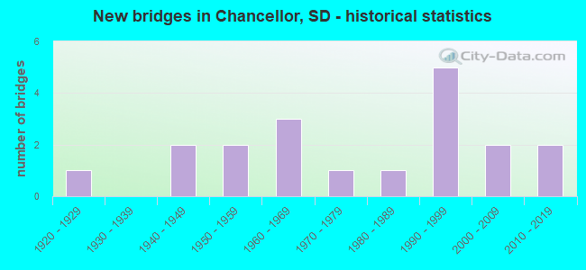
- New bridges - historical statistics
- 11920-1929
- 21940-1949
- 21950-1959
- 31960-1969
- 11970-1979
- 11980-1989
- 51990-1999
- 22000-2009
- 22010-2019


- Bridge Condition - Deck
- 7.1%Very good
- 14.3%Good
- 57.1%Satisfactory
- 14.3%Fair
- 7.1%Poor

- Bridge Condition - Superstructure
- 14.3%Very good
- 14.3%Good
- 42.9%Satisfactory
- 7.1%Fair
- 14.3%Poor
- 7.1%Serious

- Bridge Condition - Substructure
- 7.1%Very good
- 21.4%Good
- 14.3%Satisfactory
- 28.6%Fair
- 21.4%Poor
- 7.1%Serious

- Bridge Condition - Channel
- 15.8%Excellent
- 15.8%Very good
- 42.1%Good
- 21.1%Satisfactory
- 5.3%Poor

- Bridge Condition - Culverts
- 40.0%Good
- 40.0%Satisfactory
- 20.0%Poor
Find on map >> Show street view
Structure Number: 4200704, Location: 3.5W of Tea (Lat: 43.446669, Lng: -96.910797), Route carried "on" structure: County highway , Year Built: 1958, Year Reconstructed: 1970, Status: Posted for load, Structure Length: 1.04m (3.41ft), Average Daily Traffic: 108 (year 2019), Truck Traffic: 3%, Average Future Daily Traffic: 118 (year 2032), Features Intersected: Beaver Creek, Facility Carried by Structure: 272nd Street
Minimum Vertical Clearance: 30+ m (98+ ft), Kilometerpoint: 0.000, Lanes on structure: 2, Owner: County Highway Agency, Approaching Roadway Width: 7.9m (25.9ft), Material/Design: Concrete continuous, Design/Construction: Slab, Number Of Spans In Main Unit: 2, Length of Maximum Span: 4.9m (16.1ft), Curb-To-Curb Width: 8.5m (27.9ft), Out-to-Out Width: 8.9m (29.2ft)
Condition: Deck: Poor, Superstructure: Poor, Substructure: Poor, Channel: Satisfactory, Operating Rating: 13.9 metric tons, Method Used To Determine Operating Rating: Field evaluation and documented engineering judgment, Inventory Rating: 10.3 metric tons, Method Used To Determine Inventory Rating: Field evaluation and documented engineering judgment, Structural Evaluation: High priority of replacement, Deck Geometry: Equal to present minimum criteria, Waterway Adequacy: Equal to present desirable criteria, Approach Roadway Alignment: Equal to present desirable criteria, Bridge Posting: Required (Relationship of Operating Rating to Maximum Legal Load: > 39.9% below), Length Of Structure Improvement: 1.22m (4.00ft), Designated Inspection Frequency: Every 24 months, Inspection Date: June 2020, Bridge Improvement Cost: $656,000, Roadway Improvement Cost: $30,000, Total Project Cost: $686,000 ( Estimate for 2020), Deck Structure Type: Concrete Cast-file-Place, Wearing Surface/Protective System: Wearing Surface: Bituminous
Find on map >> Show street view
Structure Number: 4201816, Location: 5S & 0.2W of Lennox (Lat: 43.272439, Lng: -96.887792), Route carried "on" structure: Other road , Year Built: 1991, Status: Open, Structure Length: 2.84m (9.32ft), Average Daily Traffic: 55 (year 2019), Truck Traffic: 2%, Average Future Daily Traffic: 55 (year 2032), Design Load: HL 93, Features Intersected: Long Creek, Facility Carried by Structure: 284th Street
Minimum Vertical Clearance: 30+ m (98+ ft), Kilometerpoint: 0.000, Lanes on structure: 2, Owner: County Highway Agency, Approaching Roadway Width: 5.5m (18.0ft), Skew: 1 degrees, Material/Design: Concrete continuous, Design/Construction: Slab, Number Of Spans In Main Unit: 3, Length of Maximum Span: 10.7m (35.1ft), Curb-To-Curb Width: 8.5m (27.9ft), Out-to-Out Width: 9.4m (30.8ft)
Condition: Deck: Satisfactory, Superstructure: Satisfactory, Substructure: Good, Channel: Satisfactory, Operating Rating: 40.7 metric tons, Method Used To Determine Operating Rating: Load and Resistance Factor (LRFR), Inventory Rating: 31.4 metric tons, Method Used To Determine Inventory Rating: Load and Resistance Factor (LRFR), Structural Evaluation: Equal to present minimum criteria, Deck Geometry: Better than present minimum criteria, Waterway Adequacy: Equal to present desirable criteria, Approach Roadway Alignment: Equal to present desirable criteria, Designated Inspection Frequency: Every 24 months, Inspection Date: May 2020, Deck Structure Type: Concrete Cast-file-Place, Wearing Surface/Protective System: Wearing Surface: Monolithic Concrete, Deck Protection: Epoxy Coated Reinforcing
Find on map >> Show street view
Structure Number: 4911607, Location: 5S & 4.6E CARTHAGE (Lat: 44.095667, Lng: -97.618483), Route carried "on" structure: County highway , Year Built: 1925, Status: Posted for load, Structure Length: 0.73m (2.40ft), Average Daily Traffic: 61 (year 2019), Truck Traffic: 2%, Average Future Daily Traffic: 62 (year 2032), Features Intersected: CK, Facility Carried by Structure: 227 ST
Minimum Vertical Clearance: 30+ m (98+ ft), Kilometerpoint: 0.000, Lanes on structure: 2, Owner: County Highway Agency, Approaching Roadway Width: 5.5m (18.0ft), Material/Design: Steel, Design/Construction: Stringer/Multi-beam, Number Of Spans In Main Unit: 1, Length of Maximum Span: 6.7m (22.0ft), Curb-To-Curb Width: 6.1m (20.0ft), Out-to-Out Width: 6.6m (21.7ft)
Condition: Deck: Fair, Superstructure: Poor, Substructure: Fair, Channel: Good, Operating Rating: 16.2 metric tons, Method Used To Determine Operating Rating: Load Factor (LF), Inventory Rating: 9.7 metric tons, Method Used To Determine Inventory Rating: Load Factor (LF), Structural Evaluation: High priority of replacement, Deck Geometry: Somewhat better than minimum adequacy, Waterway Adequacy: Somewhat better than minimum adequacy, Approach Roadway Alignment: Somewhat better than minimum adequacy, Bridge Posting: Required (Relationship of Operating Rating to Maximum Legal Load: > 39.9% below), Length Of Structure Improvement: 1.22m (4.00ft), Designated Inspection Frequency: Every 24 months, Inspection Date: July 2020, Bridge Improvement Cost: $168,000, Roadway Improvement Cost: $20,000, Total Project Cost: $189,000, Deck Structure Type: Concrete Cast-file-Place, Wearing Surface/Protective System: Wearing Surface: Gravel
Find on map >> Show street view
Structure Number: 6317409, Location: 1.4 E JCT SD 19 (Lat: 43.373044, Lng: -97.054200), Route carried "on" structure: State highway 44, Year Built: 1968, Status: Open, Structure Length: 5.67m (18.60ft), Average Daily Traffic: 887 (year 2021), Truck Traffic: 25%, Average Future Daily Traffic: 1,484 (year 2041), Design Load: HS 20, Features Intersected: VERMILLION RV
Minimum Vertical Clearance: 30+ m (98+ ft), Kilometerpoint: 639.296, Lanes on structure: 2, Base Highway Network: Yes, Owner: State Highway Agency, Approaching Roadway Width: 12.2m (40.0ft), Material/Design: Concrete continuous, Design/Construction: Slab, Number Of Spans In Main Unit: 5, Length of Maximum Span: 11.8m (38.7ft), Curb-To-Curb Width: 12.2m (40.0ft), Out-to-Out Width: 13.0m (42.7ft)
Condition: Deck: Good, Superstructure: Good, Substructure: Good, Channel: Satisfactory, Operating Rating: 61.4 metric tons, Method Used To Determine Operating Rating: Load Factor (LF), Inventory Rating: 36.7 metric tons, Method Used To Determine Inventory Rating: Load Factor (LF), Structural Evaluation: Better than present minimum criteria, Deck Geometry: Equal to present desirable criteria, Waterway Adequacy: Equal to present desirable criteria, Approach Roadway Alignment: Equal to present desirable criteria, Designated Inspection Frequency: Every 24 months, Inspection Date: March 2021, Deck Structure Type: Concrete Cast-file-Place, Wearing Surface/Protective System: Wearing Surface: Epoxy Overlay, Membrane: Epoxy
Find on map >> Show street view
Structure Number: 6317707, Location: 4.7E PARKER (Lat: 43.402103, Lng: -97.049019), Route carried "on" structure: County highway , Year Built: 2014, Status: Open, Structure Length: 0.94m (3.08ft), Average Daily Traffic: 743 (year 2019), Truck Traffic: 3%, Average Future Daily Traffic: 743 (year 2032), Features Intersected: ELCE CK, Facility Carried by Structure: 45770 275 ST
Minimum Vertical Clearance: 30+ m (98+ ft), Kilometerpoint: 0.000, Lanes on structure: 2, Owner: County Highway Agency, Approaching Roadway Width: 7.9m (25.9ft), Material/Design: Steel, Design/Construction: Culvert, Number Of Spans In Main Unit: 4, Length of Maximum Span: 2.0m (6.6ft)
Condition: Channel: Good, Culverts: Good, Structural Evaluation: Better than present minimum criteria, Waterway Adequacy: Better than present minimum criteria, Approach Roadway Alignment: Equal to present minimum criteria, Designated Inspection Frequency: Every 24 months, Inspection Date: August 2021
Find on map >> Show street view
Structure Number: 6317808, Location: 1S & 4.8E PARKER (Lat: 43.387642, Lng: -97.045711), Route carried "on" structure: County highway , Year Built: 1997, Status: Open, Structure Length: 0.75m (2.46ft), Average Daily Traffic: 25 (year 2019), Truck Traffic: 2%, Average Future Daily Traffic: 25 (year 2032), Features Intersected: ELCE CK, Facility Carried by Structure: 45780 276 ST
Minimum Vertical Clearance: 30+ m (98+ ft), Kilometerpoint: 0.000, Lanes on structure: 2, Owner: County Highway Agency, Approaching Roadway Width: 5.2m (17.1ft), Material/Design: Concrete, Design/Construction: Culvert, Number Of Spans In Main Unit: 2, Length of Maximum Span: 3.9m (12.8ft)
Condition: Channel: Good, Culverts: Good, Operating Rating: 32.7 metric tons, Method Used To Determine Operating Rating: Field evaluation and documented engineering judgment, Inventory Rating: 24.5 metric tons, Method Used To Determine Inventory Rating: Field evaluation and documented engineering judgment, Structural Evaluation: Equal to present minimum criteria, Waterway Adequacy: Meets minimum limits, Approach Roadway Alignment: Better than present minimum criteria, Length Of Structure Improvement: 3.96m (12.99ft), Designated Inspection Frequency: Every 24 months, Inspection Date: August 2021, Bridge Improvement Cost: $17,000, Roadway Improvement Cost: $5,000, Total Project Cost: $25,000, Wearing Surface/Protective System: Wearing Surface: Monolithic Concrete
Find on map >> Show street view
Structure Number: 63180089, Location: 1.9S & 5E PARKER (Lat: 43.373639, Lng: -97.042739), Route carried "on" structure: County highway , Year Built: 1950, Status: Posted for load, Structure Length: 0.75m (2.46ft), Average Daily Traffic: 25 (year 2019), Truck Traffic: 2%, Average Future Daily Traffic: 25 (year 2032), Features Intersected: ELCE CK, Facility Carried by Structure: 27690 458 AVE
Minimum Vertical Clearance: 30+ m (98+ ft), Kilometerpoint: 0.000, Lanes on structure: 2, Owner: County Highway Agency, Approaching Roadway Width: 7.6m (24.9ft), Material/Design: Masonry, Design/Construction: Culvert, Number Of Spans In Main Unit: 2, Length of Maximum Span: 3.0m (9.8ft)
Condition: Channel: Very good, Culverts: Poor, Operating Rating: 24.5 metric tons, Method Used To Determine Operating Rating: Field evaluation and documented engineering judgment, Inventory Rating: 18.3 metric tons, Method Used To Determine Inventory Rating: Field evaluation and documented engineering judgment, Structural Evaluation: Meets minimum limits, Waterway Adequacy: Better than present minimum criteria, Approach Roadway Alignment: Equal to present desirable criteria, Bridge Posting: Required (Relationship of Operating Rating to Maximum Legal Load: 20.0 - 29.9% below), Length Of Structure Improvement: 1.37m (4.49ft), Designated Inspection Frequency: Every 24 months, Inspection Date: September 2021, Bridge Improvement Cost: $169,000, Roadway Improvement Cost: $19,000, Total Project Cost: $325,000
Find on map >> Show street view
Structure Number: 6318109, Location: 2.1 E JCT SD 19 (Lat: 43.373067, Lng: -97.042206), Route carried "on" structure: State highway 44, Year Built: 1968, Status: Open, Structure Length: 0.63m (2.07ft), Average Daily Traffic: 887 (year 2021), Truck Traffic: 25%, Average Future Daily Traffic: 1,484 (year 2041), Design Load: HS 20, Features Intersected: ELCE CK
Minimum Vertical Clearance: 30+ m (98+ ft), Kilometerpoint: 640.278, Lanes on structure: 2, Base Highway Network: Yes, Owner: State Highway Agency, Approaching Roadway Width: 12.2m (40.0ft), Material/Design: Concrete continuous, Design/Construction: Culvert, Number Of Spans In Main Unit: 2, Length of Maximum Span: 3.0m (9.8ft)
Condition: Channel: Good, Culverts: Satisfactory, Operating Rating: 89.8 metric tons, Method Used To Determine Operating Rating: Load Factor (LF), Inventory Rating: 63.9 metric tons, Method Used To Determine Inventory Rating: Load Factor (LF), Structural Evaluation: Equal to present minimum criteria, Waterway Adequacy: Equal to present desirable criteria, Approach Roadway Alignment: Equal to present desirable criteria, Designated Inspection Frequency: Every 48 months, Inspection Date: January 2022
Find on map >> Show street view
Structure Number: 631861, Location: 1S & 2.3W CHANCELLOR (Lat: 43.358792, Lng: -97.031383), Route carried "on" structure: County highway , Year Built: 1940, Status: Posted for load, Structure Length: 3.90m (12.80ft), Average Daily Traffic: 65 (year 2019), Truck Traffic: 2%, Average Future Daily Traffic: 65 (year 2032), Features Intersected: VERMILLION RV, Facility Carried by Structure: 45860 278 ST
Minimum Vertical Clearance: 30+ m (98+ ft), Kilometerpoint: 0.000, Lanes on structure: 2, Owner: County Highway Agency, Approaching Roadway Width: 6.1m (20.0ft), Material/Design: Steel, Design/Construction: Stringer/Multi-beam, Number Of Spans In Main Unit: 4, Length of Maximum Span: 9.3m (30.5ft), Curb-To-Curb Width: 5.5m (18.0ft), Out-to-Out Width: 5.9m (19.4ft)
Condition: Deck: Satisfactory, Superstructure: Serious, Substructure: Serious, Channel: Good, Operating Rating: 16.3 metric tons, Method Used To Determine Operating Rating: Field evaluation and documented engineering judgment, Inventory Rating: 12.2 metric tons, Method Used To Determine Inventory Rating: Field evaluation and documented engineering judgment, Structural Evaluation: High priority of corrective action, Deck Geometry: Meets minimum limits, Waterway Adequacy: Equal to present desirable criteria, Approach Roadway Alignment: Equal to present desirable criteria, Bridge Posting: Required (Relationship of Operating Rating to Maximum Legal Load: > 39.9% below), Length Of Structure Improvement: 4.88m (16.01ft), Designated Inspection Frequency: Every 24 months, Inspection Date: October 2021, Bridge Improvement Cost: $441,000, Roadway Improvement Cost: $46,000, Total Project Cost: $730,000, Deck Structure Type: Concrete Cast-file-Place, Wearing Surface/Protective System: Wearing Surface: Gravel
Find on map >> Show street view
Structure Number: 63190106, Location: 1.6S & 2W CHANCELLOR (Lat: 43.350003, Lng: -97.023803), Route carried "on" structure: County highway , Year Built: 1993, Status: Open, Structure Length: 3.69m (12.11ft), Average Daily Traffic: 97 (year 2019), Truck Traffic: 2%, Average Future Daily Traffic: 97 (year 2032), Features Intersected: VERMILLION RV, Facility Carried by Structure: 27860 459 AVE
Minimum Vertical Clearance: 30+ m (98+ ft), Kilometerpoint: 0.000, Lanes on structure: 2, Owner: County Highway Agency, Approaching Roadway Width: 6.1m (20.0ft), Skew: 2 degrees, Material/Design: Prestressed concrete, Design/Construction: Tee Beam, Number Of Spans In Main Unit: 2, Length of Maximum Span: 18.0m (59.1ft), Curb-To-Curb Width: 7.2m (23.6ft), Out-to-Out Width: 7.4m (24.3ft)
Condition: Deck: Fair, Superstructure: Satisfactory, Substructure: Fair, Channel: Satisfactory, Operating Rating: 32.7 metric tons, Method Used To Determine Operating Rating: Field evaluation and documented engineering judgment, Inventory Rating: 24.5 metric tons, Method Used To Determine Inventory Rating: Field evaluation and documented engineering judgment, Structural Evaluation: Somewhat better than minimum adequacy, Deck Geometry: Somewhat better than minimum adequacy, Waterway Adequacy: Meets minimum limits, Approach Roadway Alignment: Better than present minimum criteria, Length Of Structure Improvement: 3.96m (12.99ft), Designated Inspection Frequency: Every 24 months, Inspection Date: September 2021, Bridge Improvement Cost: $17,000, Roadway Improvement Cost: $5,000, Total Project Cost: $25,000, Deck Structure Type: Concrete Precast Panels, Wearing Surface/Protective System: Wearing Surface: Monolithic Concrete
Find on map >> Show street view
Structure Number: 6319209, Location: 3.1 E JCT SD 19 (Lat: 43.373308, Lng: -97.020019), Route carried "on" structure: State highway 44, Year Built: 1968, Status: Open, Structure Length: 0.73m (2.40ft), Average Daily Traffic: 887 (year 2021), Truck Traffic: 25%, Average Future Daily Traffic: 1,484 (year 2041), Design Load: HS 20, Features Intersected: CAMP CK
Minimum Vertical Clearance: 30+ m (98+ ft), Kilometerpoint: 642.064, Lanes on structure: 2, Base Highway Network: Yes, Owner: State Highway Agency, Approaching Roadway Width: 12.2m (40.0ft), Skew: 3 degrees, Material/Design: Concrete continuous, Design/Construction: Culvert, Number Of Spans In Main Unit: 2, Length of Maximum Span: 3.5m (11.5ft)
Condition: Channel: Very good, Culverts: Satisfactory, Operating Rating: 87.6 metric tons, Method Used To Determine Operating Rating: Load Factor (LF), Inventory Rating: 52.4 metric tons, Method Used To Determine Inventory Rating: Load Factor (LF), Structural Evaluation: Equal to present minimum criteria, Waterway Adequacy: Equal to present desirable criteria, Approach Roadway Alignment: Equal to present desirable criteria, Designated Inspection Frequency: Every 48 months, Inspection Date: January 2022
Find on map >> Show street view
Structure Number: 6319412, Location: 3S & 1.7W CHANCELLOR (Lat: 43.329881, Lng: -97.018581), Route carried "on" structure: County highway , Year Built: 2019, Status: Open, Structure Length: 5.85m (19.19ft), Average Daily Traffic: 254 (year 2019), Truck Traffic: 3%, Average Future Daily Traffic: 254 (year 2032), Design Load: HL 93, Features Intersected: VERMILLION RV, Facility Carried by Structure: 45940 280 ST
Minimum Vertical Clearance: 30+ m (98+ ft), Kilometerpoint: 0.000, Lanes on structure: 2, Owner: County Highway Agency, Approaching Roadway Width: 7.9m (25.9ft), Material/Design: Prestressed concrete, Design/Construction: Stringer/Multi-beam, Number Of Spans In Main Unit: 3, Length of Maximum Span: 20.1m (65.9ft), Curb-To-Curb Width: 9.1m (29.9ft), Out-to-Out Width: 10.0m (32.8ft)
Condition: Deck: Very good, Superstructure: Very good, Substructure: Very good, Channel: Very good, Operating Rating: 43.7 metric tons, Method Used To Determine Operating Rating: Load and Resistance Factor (LRFR), Inventory Rating: 33.9 metric tons, Method Used To Determine Inventory Rating: Load and Resistance Factor (LRFR), Structural Evaluation: Equal to present desirable criteria, Deck Geometry: Equal to present minimum criteria, Waterway Adequacy: Superior to present desirable criteria, Approach Roadway Alignment: Superior to present desirable criteria, Designated Inspection Frequency: Every 24 months, Inspection Date: October 2021, Deck Structure Type: Concrete Cast-file-Place, Wearing Surface/Protective System: Wearing Surface: Integral Concrete, Deck Protection: Epoxy Coated Reinforcing
Find on map >> Show street view
Structure Number: 6319711, Location: 2S & 1.3W CHANCELLOR (Lat: 43.344383, Lng: -97.011225), Route carried "on" structure: County highway , Year Built: 1985, Status: Posted for load, Structure Length: 1.92m (6.30ft), Average Daily Traffic: 97 (year 2019), Truck Traffic: 2%, Average Future Daily Traffic: 97 (year 2032), Features Intersected: VERMILLION RV, Facility Carried by Structure: 45970 279 ST.
Minimum Vertical Clearance: 30+ m (98+ ft), Kilometerpoint: 0.000, Lanes on structure: 2, Owner: County Highway Agency, Approaching Roadway Width: 6.1m (20.0ft), Material/Design: Steel, Design/Construction: Stringer/Multi-beam, Number Of Spans In Main Unit: 2, Length of Maximum Span: 9.3m (30.5ft), Curb-To-Curb Width: 6.1m (20.0ft), Out-to-Out Width: 6.1m (20.0ft)
Condition: Deck: Satisfactory, Superstructure: Fair, Substructure: Poor, Channel: Poor, Operating Rating: 15.7 metric tons, Method Used To Determine Operating Rating: Allowable Stress (AS), Inventory Rating: 11.4 metric tons, Method Used To Determine Inventory Rating: Allowable Stress (AS), Structural Evaluation: Meets minimum limits, Deck Geometry: Somewhat better than minimum adequacy, Waterway Adequacy: Meets minimum limits, Approach Roadway Alignment: Equal to present minimum criteria, Bridge Posting: Required (Relationship of Operating Rating to Maximum Legal Load: > 39.9% below), Length Of Structure Improvement: 2.59m (8.50ft), Designated Inspection Frequency: Every 24 months, Inspection Date: September 2021, Bridge Improvement Cost: $228,000, Roadway Improvement Cost: $25,000, Total Project Cost: $426,000, Deck Structure Type: Corrugated Steel, Wearing Surface/Protective System: Wearing Surface: Bituminous
Find on map >> Show street view
Structure Number: 63210057, Location: 3.3N CHANCELLOR (Lat: 43.421253, Lng: -96.984383), Route carried "on" structure: County highway , Year Built: 2004, Status: Open, Structure Length: 1.10m (3.61ft), Average Daily Traffic: 657 (year 2019), Truck Traffic: 3%, Average Future Daily Traffic: 657 (year 2032), Design Load: HS 20, Features Intersected: LONG CK, Facility Carried by Structure: 27370 461 AVE
Minimum Vertical Clearance: 30+ m (98+ ft), Kilometerpoint: 0.000, Lanes on structure: 2, Owner: County Highway Agency, Approaching Roadway Width: 7.3m (24.0ft), Skew: 1 degrees, Material/Design: Concrete, Design/Construction: Slab, Number Of Spans In Main Unit: 1, Length of Maximum Span: 10.4m (34.1ft), Curb-To-Curb Width: 9.0m (29.5ft), Out-to-Out Width: 9.1m (29.9ft)
Condition: Deck: Good, Superstructure: Good, Substructure: Good, Channel: Excellent, Operating Rating: 72.1 metric tons, Method Used To Determine Operating Rating: Load Factor (LF), Inventory Rating: 43.2 metric tons, Method Used To Determine Inventory Rating: Load Factor (LF), Structural Evaluation: Better than present minimum criteria, Deck Geometry: Somewhat better than minimum adequacy, Waterway Adequacy: Superior to present desirable criteria, Approach Roadway Alignment: Superior to present desirable criteria, Designated Inspection Frequency: Every 24 months, Inspection Date: July 2021, Deck Structure Type: Concrete Cast-file-Place, Wearing Surface/Protective System: Wearing Surface: Integral Concrete, Deck Protection: Epoxy Coated Reinforcing
Find on map >> Show street view
Structure Number: 6321206, Location: 3N & 0.2E CHANCELLOR (Lat: 43.417275, Lng: -96.978150), Route carried "on" structure: County highway , Year Built: 2000, Status: Open, Structure Length: 1.09m (3.58ft), Average Daily Traffic: 50 (year 2019), Truck Traffic: 2%, Average Future Daily Traffic: 50 (year 2032), Design Load: HS 20, Features Intersected: LONG CK, Facility Carried by Structure: 46120 274 ST
Minimum Vertical Clearance: 30+ m (98+ ft), Kilometerpoint: 0.000, Lanes on structure: 2, Owner: County Highway Agency, Approaching Roadway Width: 7.3m (24.0ft), Material/Design: Prestressed concrete, Design/Construction: Stringer/Multi-beam, Number Of Spans In Main Unit: 1, Length of Maximum Span: 10.7m (35.1ft), Curb-To-Curb Width: 7.5m (24.6ft), Out-to-Out Width: 8.3m (27.2ft)
Condition: Deck: Satisfactory, Superstructure: Very good, Substructure: Fair, Channel: Good, Operating Rating: 32.7 metric tons, Method Used To Determine Operating Rating: Field evaluation and documented engineering judgment, Inventory Rating: 24.5 metric tons, Method Used To Determine Inventory Rating: Field evaluation and documented engineering judgment, Structural Evaluation: Somewhat better than minimum adequacy, Deck Geometry: Equal to present minimum criteria, Waterway Adequacy: Superior to present desirable criteria, Approach Roadway Alignment: Equal to present minimum criteria, Length Of Structure Improvement: 3.96m (12.99ft), Designated Inspection Frequency: Every 24 months, Inspection Date: July 2021, Bridge Improvement Cost: $17,000, Roadway Improvement Cost: $5,000, Total Project Cost: $25,000, Deck Structure Type: Concrete Precast Panels, Wearing Surface/Protective System: Wearing Surface: Integral Concrete
Find on map >> Show street view
Structure Number: 63220069, Location: 2.1N & 1E CHANCELLOR (Lat: 43.402992, Lng: -96.964267), Route carried "on" structure: County highway , Year Built: 1945, Status: Posted for load, Structure Length: 0.91m (2.99ft), Average Daily Traffic: 65 (year 2019), Truck Traffic: 2%, Average Future Daily Traffic: 65 (year 2032), Features Intersected: LONG CK, Facility Carried by Structure: 27490 462 AVE
Minimum Vertical Clearance: 30+ m (98+ ft), Kilometerpoint: 0.000, Lanes on structure: 2, Owner: County Highway Agency, Approaching Roadway Width: 6.7m (22.0ft), Material/Design: Steel, Design/Construction: Stringer/Multi-beam, Number Of Spans In Main Unit: 1, Length of Maximum Span: 8.0m (26.2ft), Curb-To-Curb Width: 7.5m (24.6ft), Out-to-Out Width: 7.5m (24.6ft)
Condition: Deck: Satisfactory, Superstructure: Satisfactory, Substructure: Poor, Channel: Good, Operating Rating: 25.4 metric tons, Method Used To Determine Operating Rating: Field evaluation and documented engineering judgment, Inventory Rating: 19.1 metric tons, Method Used To Determine Inventory Rating: Field evaluation and documented engineering judgment, Structural Evaluation: Meets minimum limits, Deck Geometry: Equal to present minimum criteria, Waterway Adequacy: Equal to present desirable criteria, Approach Roadway Alignment: Equal to present desirable criteria, Bridge Posting: Required (Relationship of Operating Rating to Maximum Legal Load: 10.0 - 19.9% below), Length Of Structure Improvement: 1.52m (4.99ft), Designated Inspection Frequency: Every 24 months, Inspection Date: August 2021, Bridge Improvement Cost: $188,000, Roadway Improvement Cost: $21,000, Total Project Cost: $350,000, Deck Structure Type: Concrete Cast-file-Place, Wearing Surface/Protective System: Wearing Surface: Gravel
Find on map >> Show street view
Structure Number: 6322207, Location: 2N & 1.2E CHANCELLOR (Lat: 43.402783, Lng: -96.961353), Route carried "on" structure: County highway , Year Built: 1977, Status: Open, Structure Length: 1.22m (4.00ft), Average Daily Traffic: 570 (year 2019), Truck Traffic: 3%, Average Future Daily Traffic: 570 (year 2032), Design Load: HS 20, Features Intersected: LONG CK, Facility Carried by Structure: 46220 275 ST
Minimum Vertical Clearance: 30+ m (98+ ft), Kilometerpoint: 0.000, Lanes on structure: 2, Owner: County Highway Agency, Approaching Roadway Width: 6.7m (22.0ft), Material/Design: Prestressed concrete, Design/Construction: Tee Beam, Number Of Spans In Main Unit: 1, Length of Maximum Span: 11.9m (39.0ft), Curb-To-Curb Width: 9.1m (29.9ft), Out-to-Out Width: 9.4m (30.8ft)
Condition: Deck: Satisfactory, Superstructure: Satisfactory, Substructure: Satisfactory, Channel: Good, Operating Rating: 32.7 metric tons, Method Used To Determine Operating Rating: Field evaluation and documented engineering judgment, Inventory Rating: 24.5 metric tons, Method Used To Determine Inventory Rating: Field evaluation and documented engineering judgment, Structural Evaluation: Equal to present minimum criteria, Deck Geometry: Equal to present minimum criteria, Waterway Adequacy: Better than present minimum criteria, Approach Roadway Alignment: Equal to present desirable criteria, Length Of Structure Improvement: 3.96m (12.99ft), Designated Inspection Frequency: Every 12 months, Inspection Date: August 2021, Bridge Improvement Cost: $17,000, Roadway Improvement Cost: $5,000, Total Project Cost: $25,000, Deck Structure Type: Concrete Precast Panels, Wearing Surface/Protective System: Wearing Surface: Bituminous
Find on map >> Show street view
Structure Number: 6322708, Location: 1N & 1.7E CHANCELLOR (Lat: 43.388464, Lng: -96.950100), Route carried "on" structure: County highway , Year Built: 1998, Status: Open, Structure Length: 1.25m (4.10ft), Average Daily Traffic: 97 (year 2019), Truck Traffic: 2%, Average Future Daily Traffic: 97 (year 2032), Design Load: HS 20, Features Intersected: LONG CK, Facility Carried by Structure: 46270 226 ST
Minimum Vertical Clearance: 30+ m (98+ ft), Kilometerpoint: 0.000, Lanes on structure: 2, Owner: County Highway Agency, Approaching Roadway Width: 6.1m (20.0ft), Skew: 3 degrees, Material/Design: Prestressed concrete, Design/Construction: Tee Beam, Number Of Spans In Main Unit: 1, Length of Maximum Span: 12.2m (40.0ft), Curb-To-Curb Width: 6.6m (21.7ft), Out-to-Out Width: 7.4m (24.3ft)
Condition: Deck: Satisfactory, Superstructure: Satisfactory, Substructure: Fair, Channel: Excellent, Operating Rating: 32.7 metric tons, Method Used To Determine Operating Rating: Field evaluation and documented engineering judgment, Inventory Rating: 24.5 metric tons, Method Used To Determine Inventory Rating: Field evaluation and documented engineering judgment, Structural Evaluation: Somewhat better than minimum adequacy, Deck Geometry: Somewhat better than minimum adequacy, Waterway Adequacy: Superior to present desirable criteria, Approach Roadway Alignment: Equal to present minimum criteria, Length Of Structure Improvement: 3.96m (12.99ft), Designated Inspection Frequency: Every 24 months, Inspection Date: September 2021, Bridge Improvement Cost: $17,000, Roadway Improvement Cost: $5,000, Total Project Cost: $25,000, Deck Structure Type: Concrete Precast Panels, Wearing Surface/Protective System: Wearing Surface: Integral Concrete
Find on map >> Show street view
Structure Number: 63230088, Location: 2E & 0.2N CHANCELLOR (Lat: 43.378431, Lng: -96.944378), Route carried "on" structure: County highway , Year Built: 1998, Status: Open, Structure Length: 1.38m (4.53ft), Average Daily Traffic: 97 (year 2019), Truck Traffic: 2%, Average Future Daily Traffic: 97 (year 2032), Design Load: HS 20, Features Intersected: LONG CK, Facility Carried by Structure: 27680 463 AVE
Minimum Vertical Clearance: 30+ m (98+ ft), Kilometerpoint: 0.000, Lanes on structure: 2, Owner: County Highway Agency, Approaching Roadway Width: 6.1m (20.0ft), Material/Design: Prestressed concrete, Design/Construction: Tee Beam, Number Of Spans In Main Unit: 1, Length of Maximum Span: 13.8m (45.3ft), Curb-To-Curb Width: 6.6m (21.7ft), Out-to-Out Width: 7.3m (24.0ft)
Condition: Deck: Satisfactory, Superstructure: Satisfactory, Substructure: Satisfactory, Channel: Excellent, Operating Rating: 32.7 metric tons, Method Used To Determine Operating Rating: Field evaluation and documented engineering judgment, Inventory Rating: 24.5 metric tons, Method Used To Determine Inventory Rating: Field evaluation and documented engineering judgment, Structural Evaluation: Equal to present minimum criteria, Deck Geometry: Somewhat better than minimum adequacy, Waterway Adequacy: Superior to present desirable criteria, Approach Roadway Alignment: Equal to present minimum criteria, Length Of Structure Improvement: 3.96m (12.99ft), Designated Inspection Frequency: Every 24 months, Inspection Date: September 2021, Bridge Improvement Cost: $17,000, Roadway Improvement Cost: $5,000, Total Project Cost: $25,000, Deck Structure Type: Concrete Precast Panels, Wearing Surface/Protective System: Wearing Surface: Integral Concrete