Bridge Statistics for Channelview, Texas (TX)
Condition, Traffic, Stress, Structural Evaluation, Project Costs
- National Bridge Inventory (NBI) Statistics
- 42Number of bridges
- 1,417ft / 432mTotal length
- $3,314,000Total costs
- 1,732,752Total average daily traffic
- 249,821Total average daily truck traffic
- National Bridge Inventory (NBI) Registered Bridges for Channelview
- No street view available for this location
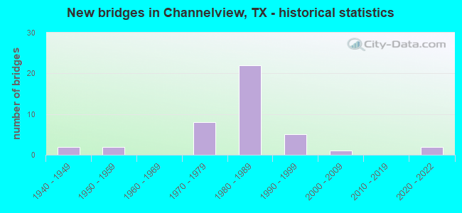
- New bridges - historical statistics
- 21940-1949
- 21950-1959
- 81970-1979
- 221980-1989
- 51990-1999
- 12000-2009
- 22020-2022
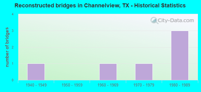
- Reconstructed bridges - Historical Statistics
- 11940-1949
- 01950-1959
- 11960-1969
- 11970-1979
- 31980-1989
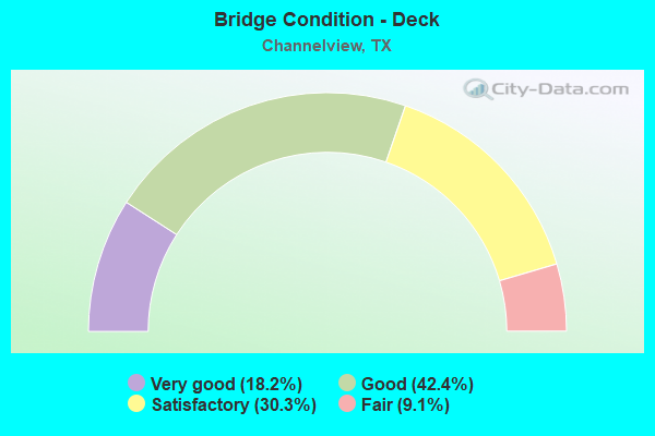
- Bridge Condition - Deck
- 18.2%Very good
- 42.4%Good
- 30.3%Satisfactory
- 9.1%Fair
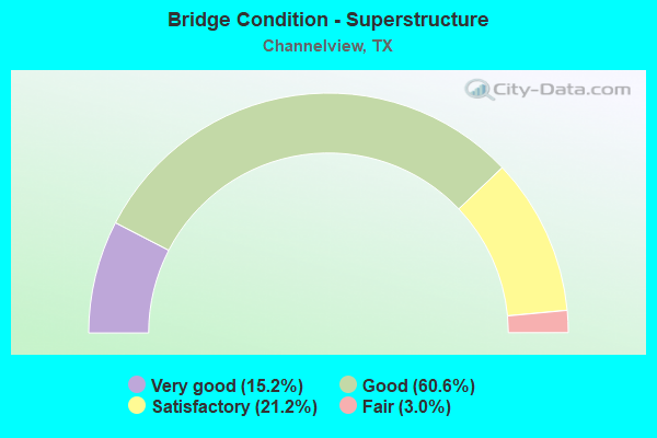
- Bridge Condition - Superstructure
- 15.2%Very good
- 60.6%Good
- 21.2%Satisfactory
- 3.0%Fair
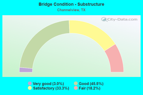
- Bridge Condition - Substructure
- 3.0%Very good
- 45.5%Good
- 33.3%Satisfactory
- 18.2%Fair
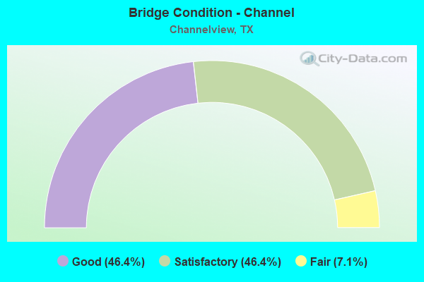
- Bridge Condition - Channel
- 46.4%Good
- 46.4%Satisfactory
- 7.1%Fair
Find on map >> Show street view
Structure Number: 121020050801065, Location: 1.25 MI E OF SHELDON RD (Lat: 29.785544, Lng: -95.105164), Route carried "on" structure: Interstate 10, Year Built: 1956, Year Reconstructed: 1982, Status: Open, Structure Length: 3.90m (12.80ft), Average Daily Traffic: 122,318 (year 2019), Truck Traffic: 20%, Average Future Daily Traffic: 156,320 (year 2033), Design Load: HS 20, Features Intersected: FRESH WATER BAYOU
Minimum Vertical Clearance: 30+ m (98+ ft), Kilometerpoint: 70.042, Lanes on structure: 6, Owner: State Highway Agency, Approaching Roadway Width: 36.6m (120.1ft), Skew: 33 degrees, Material/Design: Concrete, Design/Construction: Slab, Number Of Spans In Main Unit: 5, Length of Maximum Span: 7.9m (25.9ft), Curb-To-Curb Width: 36.6m (120.1ft), Out-to-Out Width: 37.8m (124.0ft)
Condition: Deck: Satisfactory, Superstructure: Satisfactory, Substructure: Fair, Channel: Good, Operating Rating: 44.4 metric tons, Method Used To Determine Operating Rating: Assigned ratings based on Allowable Stress Design (ASD) reported in metric tons, Inventory Rating: 32.7 metric tons, Method Used To Determine Inventory Rating: Assigned ratings based on Allowable Stress Design (ASD) reported in metric tons, Structural Evaluation: Somewhat better than minimum adequacy, Deck Geometry: Superior to present desirable criteria, Waterway Adequacy: Equal to present minimum criteria, Approach Roadway Alignment: Equal to present desirable criteria, Designated Inspection Frequency: Every 24 months, Inspection Date: October 2020, Deck Structure Type: Concrete Cast-file-Place, Wearing Surface/Protective System: Wearing Surface: Bituminous
Find on map >> Show street view
Structure Number: 121020050801067, Location: 1.25 MI E OF SHELDON RD (Lat: 29.785239, Lng: -95.105036), Route carried "on" structure: ServiceInterstate 10, Year Built: 1956, Status: Open, Structure Length: 3.90m (12.80ft), Average Daily Traffic: 130 (year 2013), Truck Traffic: 17%, Average Future Daily Traffic: 180 (year 2033), Features Intersected: FRESH WATER BAYOU
Minimum Vertical Clearance: 30+ m (98+ ft), Kilometerpoint: 70.035, Lanes on structure: 2, Owner: State Highway Agency, Approaching Roadway Width: 7.3m (24.0ft), Skew: 3 degrees, Material/Design: Concrete, Design/Construction: Slab, Number Of Spans In Main Unit: 5, Length of Maximum Span: 7.9m (25.9ft), Curb-To-Curb Width: 9.1m (29.9ft), Out-to-Out Width: 9.8m (32.2ft)
Condition: Deck: Satisfactory, Superstructure: Satisfactory, Substructure: Satisfactory, Channel: Good, Operating Rating: 50.8 metric tons, Method Used To Determine Operating Rating: Load Factor (LF), Inventory Rating: 29.9 metric tons, Method Used To Determine Inventory Rating: Load Factor (LF), Structural Evaluation: Equal to present minimum criteria, Deck Geometry: Meets minimum limits, Waterway Adequacy: Better than present minimum criteria, Approach Roadway Alignment: Equal to present desirable criteria, Length Of Structure Improvement: 3.90m (12.80ft), Designated Inspection Frequency: Every 24 months, Inspection Date: October 2020, Deck Structure Type: Concrete Cast-file-Place
Find on map >> Show street view
Structure Number: 121020050801222, Location: IH 10 @ SAN JACINTO RIVER (Lat: 29.793558, Lng: -95.063214), Route carried "on" structure: Interstate 10, Year Built: 1971, Status: Open, Structure Length: 79.49m (260.79ft), Average Daily Traffic: 62,490 (year 2019), Truck Traffic: 20%, Average Future Daily Traffic: 78,160 (year 2033), Design Load: HS 20, Features Intersected: SAN JACINTO RIVER
Minimum Vertical Clearance: 30+ m (98+ ft), Kilometerpoint: 73.912, Lanes on structure: 3, Owner: State Highway Agency, Approaching Roadway Width: 15.9m (52.2ft), Skew: 9 degrees, Material/Design: Steel continuous, Design/Construction: Stringer/Multi-beam, Number Of Spans In Main Unit: 3, Number Of Approach Spans: 28, Length of Maximum Span: 67.1m (220.1ft), Curb-To-Curb Width: 15.9m (52.2ft), Out-to-Out Width: 16.4m (53.8ft)
Condition: Deck: Satisfactory, Superstructure: Satisfactory, Substructure: Fair, Channel: Satisfactory, Operating Rating: 54.4 metric tons, Method Used To Determine Operating Rating: Assigned rating based on Load Factor Design (LFD) reported in metric tons, Inventory Rating: 32.7 metric tons, Method Used To Determine Inventory Rating: Assigned rating based on Load Factor Design (LFD) reported in metric tons, Structural Evaluation: Somewhat better than minimum adequacy, Deck Geometry: Somewhat better than minimum adequacy, Waterway Adequacy: Superior to present desirable criteria, Approach Roadway Alignment: Equal to present desirable criteria, Length Of Structure Improvement: 79.46m (260.70ft), Designated Inspection Frequency: Every 24 months, Underwater Inspection Frequency: Every 60 months, Inspection Date: October 2020, Underwater Inspection Date: June 2018, Bridge Improvement Cost: $2,607,000, Roadway Improvement Cost: $652,000, Total Project Cost: $3,259,000, Deck Structure Type: Concrete Cast-file-Place
Find on map >> Show street view
Structure Number: 121020050801245, Location: 2.20 MI E OF SHELDON RD (Lat: 29.790500, Lng: -95.089633), Route carried "on" structure: City street , Year Built: 1982, Status: Open, Structure Length: 5.03m (16.50ft), Average Daily Traffic: 3,500 (year 2011), Truck Traffic: 15%, Average Future Daily Traffic: 6,000 (year 2030), Design Load: HS 20, Features Intersected: IH 10, Facility Carried by Structure: MAGNOLIA AVE
Minimum Vertical Clearance: 30+ m (98+ ft), Kilometerpoint: 71.667, Lanes on structure: 2, Lanes under structure: 6, Owner: State Highway Agency, Approaching Roadway Width: 15.2m (49.9ft), Skew: 1 degrees, Material/Design: Prestressed concrete, Design/Construction: Box Beam or Girders - Multiple, Number Of Spans In Main Unit: 2, Length of Maximum Span: 25.3m (83.0ft), Curb or Sidewalk Widths: Left: 1.5m (4.9ft), Right: 1.5m (4.9ft), Curb-To-Curb Width: 14.9m (48.9ft), Out-to-Out Width: 18.6m (61.0ft)
Condition: Deck: Very good, Superstructure: Good, Substructure: Good, Operating Rating: 54.4 metric tons, Method Used To Determine Operating Rating: Assigned rating based on Load Factor Design (LFD) reported in metric tons, Inventory Rating: 32.7 metric tons, Method Used To Determine Inventory Rating: Assigned rating based on Load Factor Design (LFD) reported in metric tons, Structural Evaluation: Better than present minimum criteria, Deck Geometry: Superior to present desirable criteria, Underclear: Equal to present minimum criteria, Approach Roadway Alignment: Equal to present desirable criteria, Designated Inspection Frequency: Every 24 months, Inspection Date: November 2020, Deck Structure Type: Concrete Cast-file-Place, Wearing Surface/Protective System: Wearing Surface: Bituminous
Find on map >> Show street view
Structure Number: 121020050801257, Location: 0.60 MI E OF BWY 8 (Lat: 29.773775, Lng: -95.142775), Route carried "on" structure: Interstate 10, Year Built: 1982, Status: Open, Structure Length: 0.79m (2.59ft), Average Daily Traffic: 116,794 (year 2020), Truck Traffic: 11%, Average Future Daily Traffic: 211,870 (year 2033), Features Intersected: DRAINAGE DITCH
Minimum Vertical Clearance: 30+ m (98+ ft), Kilometerpoint: 66.134, Lanes on structure: 15, Owner: State Highway Agency, Approaching Roadway Width: 70.4m (231.0ft), Skew: 31 degrees, Material/Design: Concrete, Design/Construction: Culvert, Number Of Spans In Main Unit: 3, Length of Maximum Span: 2.4m (7.9ft)
Condition: Channel: Good, Culverts: Satisfactory, Operating Rating: 39.9 metric tons, Method Used To Determine Operating Rating: Load Factor (LF), Inventory Rating: 23.6 metric tons, Method Used To Determine Inventory Rating: Load Factor (LF), Structural Evaluation: Somewhat better than minimum adequacy, Waterway Adequacy: Equal to present minimum criteria, Approach Roadway Alignment: Equal to present desirable criteria, Designated Inspection Frequency: Every 24 months, Inspection Date: November 2020
Find on map >> Show street view
Structure Number: 121020050801258, Location: 0.90 MI E OF BWY 8 (Lat: 29.774811, Lng: -95.138494), Route carried "on" structure: Interstate 10, Year Built: 1982, Year Reconstructed: 1994, Status: Open, Structure Length: 9.27m (30.41ft), Average Daily Traffic: 116,794 (year 2020), Truck Traffic: 11%, Average Future Daily Traffic: 211,870 (year 2033), Design Load: HS 20, Features Intersected: DELL DALE AVE
Minimum Vertical Clearance: 30+ m (98+ ft), Kilometerpoint: 66.585, Lanes on structure: 10, Lanes under structure: 8, Owner: State Highway Agency, Approaching Roadway Width: 51.2m (168.0ft), Skew: 31 degrees, Material/Design: Prestressed concrete, Design/Construction: Stringer/Multi-beam, Number Of Spans In Main Unit: 2, Number Of Approach Spans: 2, Length of Maximum Span: 26.5m (86.9ft), Curb-To-Curb Width: 51.5m (169.0ft), Out-to-Out Width: 52.7m (172.9ft)
Condition: Deck: Good, Superstructure: Good, Substructure: Satisfactory, Operating Rating: 54.4 metric tons, Method Used To Determine Operating Rating: Assigned rating based on Load Factor Design (LFD) reported in metric tons, Inventory Rating: 32.7 metric tons, Method Used To Determine Inventory Rating: Assigned rating based on Load Factor Design (LFD) reported in metric tons, Structural Evaluation: Equal to present minimum criteria, Deck Geometry: Superior to present desirable criteria, Underclear: Better than present minimum criteria, Approach Roadway Alignment: Equal to present desirable criteria, Designated Inspection Frequency: Every 24 months, Inspection Date: October 2020, Deck Structure Type: Concrete Cast-file-Place
Find on map >> Show street view
Structure Number: 121020050801259, Location: 1.50 MI E OF BWY 8 (Lat: 29.777192, Lng: -95.128742), Route carried "on" structure: Interstate 10, Year Built: 1982, Status: Open, Structure Length: 1.16m (3.81ft), Average Daily Traffic: 116,794 (year 2020), Truck Traffic: 11%, Average Future Daily Traffic: 211,870 (year 2033), Features Intersected: DRAINAGE DITCH
Minimum Vertical Clearance: 30+ m (98+ ft), Kilometerpoint: 67.475, Lanes on structure: 13, Owner: State Highway Agency, Approaching Roadway Width: 73.2m (240.2ft), Skew: 31 degrees, Material/Design: Concrete, Design/Construction: Culvert, Number Of Spans In Main Unit: 4, Length of Maximum Span: 2.4m (7.9ft)
Condition: Channel: Satisfactory, Culverts: Satisfactory, Operating Rating: 32.7 metric tons, Method Used To Determine Operating Rating: Field evaluation and documented engineering judgment, Inventory Rating: 24.5 metric tons, Method Used To Determine Inventory Rating: Field evaluation and documented engineering judgment, Structural Evaluation: Equal to present minimum criteria, Waterway Adequacy: Superior to present desirable criteria, Approach Roadway Alignment: Equal to present desirable criteria, Designated Inspection Frequency: Every 24 months, Inspection Date: October 2020
Find on map >> Show street view
Structure Number: 12102005080126, Location: 1.80 MI E OF BWY 8 (Lat: 29.778244, Lng: -95.124489), Route carried "on" structure: Interstate 10, Year Built: 1982, Year Reconstructed: 1994, Status: Open, Structure Length: 9.66m (31.69ft), Average Daily Traffic: 122,318 (year 2019), Truck Traffic: 11%, Average Future Daily Traffic: 211,870 (year 2033), Design Load: HS 20, Features Intersected: SHELDON RD
Minimum Vertical Clearance: 30+ m (98+ ft), Kilometerpoint: 67.982, Lanes on structure: 8, Lanes under structure: 8, Owner: State Highway Agency, Approaching Roadway Width: 43.9m (144.0ft), Skew: 31 degrees, Material/Design: Prestressed concrete, Design/Construction: Stringer/Multi-beam, Number Of Spans In Main Unit: 1, Number Of Approach Spans: 4, Length of Maximum Span: 26.5m (86.9ft), Curb-To-Curb Width: 43.9m (144.0ft), Out-to-Out Width: 45.4m (149.0ft)
Condition: Deck: Good, Superstructure: Good, Substructure: Good, Operating Rating: 54.4 metric tons, Method Used To Determine Operating Rating: Assigned rating based on Load Factor Design (LFD) reported in metric tons, Inventory Rating: 32.7 metric tons, Method Used To Determine Inventory Rating: Assigned rating based on Load Factor Design (LFD) reported in metric tons, Structural Evaluation: Better than present minimum criteria, Deck Geometry: Superior to present desirable criteria, Underclear: Better than present minimum criteria, Approach Roadway Alignment: Equal to present desirable criteria, Designated Inspection Frequency: Every 24 months, Inspection Date: October 2020, Deck Structure Type: Concrete Cast-file-Place
Find on map >> Show street view
Structure Number: 121020050801261, Location: 0.40 MI E OF MAGNOLIA AVE (Lat: 29.791086, Lng: -95.083914), Route carried "on" structure: Interstate 10, Year Built: 1982, Status: Open, Structure Length: 13.26m (43.50ft), Average Daily Traffic: 122,318 (year 2019), Truck Traffic: 20%, Average Future Daily Traffic: 156,320 (year 2033), Design Load: HS 20, Features Intersected: SAN JACINTO RIVER RELIEF
Minimum Vertical Clearance: 30+ m (98+ ft), Kilometerpoint: 72.181, Lanes on structure: 8, Owner: State Highway Agency, Approaching Roadway Width: 43.9m (144.0ft), Skew: 30 degrees, Material/Design: Prestressed concrete, Design/Construction: Box Beam or Girders - Multiple, Number Of Spans In Main Unit: 5, Number Of Approach Spans: 2, Length of Maximum Span: 20.4m (66.9ft), Curb-To-Curb Width: 44.1m (144.7ft), Out-to-Out Width: 45.2m (148.3ft)
Condition: Deck: Very good, Superstructure: Good, Substructure: Satisfactory, Channel: Good, Operating Rating: 54.4 metric tons, Method Used To Determine Operating Rating: Assigned rating based on Load Factor Design (LFD) reported in metric tons, Inventory Rating: 32.7 metric tons, Method Used To Determine Inventory Rating: Assigned rating based on Load Factor Design (LFD) reported in metric tons, Structural Evaluation: Equal to present minimum criteria, Deck Geometry: Superior to present desirable criteria, Waterway Adequacy: Equal to present minimum criteria, Approach Roadway Alignment: Equal to present desirable criteria, Designated Inspection Frequency: Every 24 months, Inspection Date: November 2020, Deck Structure Type: Concrete Cast-file-Place, Wearing Surface/Protective System: Wearing Surface: Bituminous
Find on map >> Show street view
Structure Number: 121020050801262, Location: 3.1 MI E OF BWY 8 (Lat: 29.785033, Lng: -95.106664), Route carried "on" structure: County highway 4773, Year Built: 1982, Status: Open, Structure Length: 5.24m (17.19ft), Average Daily Traffic: 1,830 (year 2008), Average Future Daily Traffic: 3,225 (year 2028), Design Load: HS 20, Features Intersected: IH 10, Facility Carried by Structure: CEDAR LN
Minimum Vertical Clearance: 30+ m (98+ ft), Kilometerpoint: 0.531, Lanes on structure: 4, Lanes under structure: 6, Owner: State Highway Agency, Approaching Roadway Width: 12.2m (40.0ft), Skew: 2 degrees, Material/Design: Prestressed concrete, Design/Construction: Box Beam or Girders - Multiple, Number Of Spans In Main Unit: 2, Length of Maximum Span: 26.2m (86.0ft), Curb or Sidewalk Widths: Left: 1.5m (4.9ft), Right: 1.5m (4.9ft), Curb-To-Curb Width: 14.6m (47.9ft), Out-to-Out Width: 18.6m (61.0ft)
Condition: Deck: Good, Superstructure: Good, Substructure: Good, Operating Rating: 54.4 metric tons, Method Used To Determine Operating Rating: Assigned rating based on Load Factor Design (LFD) reported in metric tons, Inventory Rating: 32.7 metric tons, Method Used To Determine Inventory Rating: Assigned rating based on Load Factor Design (LFD) reported in metric tons, Structural Evaluation: Better than present minimum criteria, Deck Geometry: High priority of replacement, Underclear: Equal to present minimum criteria, Approach Roadway Alignment: Equal to present desirable criteria, Length Of Structure Improvement: 5.24m (17.19ft), Designated Inspection Frequency: Every 24 months, Inspection Date: October 2020, Bridge Improvement Cost: $17,000, Roadway Improvement Cost: $4,000, Total Project Cost: $21,000, Deck Structure Type: Concrete Cast-file-Place, Wearing Surface/Protective System: Wearing Surface: Bituminous
Find on map >> Show street view
Structure Number: 121020050801263, Location: 3.2 MI E OF BWY 8 (Lat: 29.786111, Lng: -95.103689), Route carried "on" structure: County highway 4795, Year Built: 1981, Status: Open, Structure Length: 4.94m (16.21ft), Average Daily Traffic: 1,110 (year 2011), Average Future Daily Traffic: 1,710 (year 2030), Design Load: HS 20, Features Intersected: IH 10, Facility Carried by Structure: BAYOU ST
Minimum Vertical Clearance: 30+ m (98+ ft), Kilometerpoint: 1.642, Lanes on structure: 4, Lanes under structure: 6, Owner: State Highway Agency, Approaching Roadway Width: 12.2m (40.0ft), Material/Design: Prestressed concrete, Design/Construction: Box Beam or Girders - Multiple, Number Of Spans In Main Unit: 2, Length of Maximum Span: 24.7m (81.0ft), Curb or Sidewalk Widths: Left: 1.5m (4.9ft), Right: 1.5m (4.9ft), Curb-To-Curb Width: 14.9m (48.9ft), Out-to-Out Width: 18.6m (61.0ft)
Condition: Deck: Very good, Superstructure: Good, Substructure: Good, Operating Rating: 54.4 metric tons, Method Used To Determine Operating Rating: Assigned rating based on Load Factor Design (LFD) reported in metric tons, Inventory Rating: 32.7 metric tons, Method Used To Determine Inventory Rating: Assigned rating based on Load Factor Design (LFD) reported in metric tons, Structural Evaluation: Better than present minimum criteria, Deck Geometry: High priority of replacement, Underclear: Equal to present minimum criteria, Approach Roadway Alignment: Equal to present desirable criteria, Designated Inspection Frequency: Every 24 months, Inspection Date: November 2020, Deck Structure Type: Concrete Cast-file-Place, Wearing Surface/Protective System: Wearing Surface: Bituminous
Find on map >> Show street view
Structure Number: 121020050801265, Location: 0.40 MI E OF MONMOUTH DR (Lat: 29.794358, Lng: -95.073983), Route carried "on" structure: Interstate 10, Year Built: 1982, Status: Open, Structure Length: 9.45m (31.00ft), Average Daily Traffic: 122,318 (year 2019), Truck Traffic: 20%, Average Future Daily Traffic: 156,320 (year 2033), Design Load: HS 20, Features Intersected: SAN JACINTO RIVER RELIEF
Minimum Vertical Clearance: 30+ m (98+ ft), Kilometerpoint: 73.193, Lanes on structure: 6, Owner: State Highway Agency, Approaching Roadway Width: 36.6m (120.1ft), Skew: 30 degrees, Material/Design: Prestressed concrete, Design/Construction: Box Beam or Girders - Multiple, Number Of Spans In Main Unit: 3, Number Of Approach Spans: 2, Length of Maximum Span: 21.3m (69.9ft), Curb-To-Curb Width: 38.9m (127.6ft), Out-to-Out Width: 39.9m (130.9ft)
Condition: Deck: Good, Superstructure: Good, Substructure: Satisfactory, Channel: Good, Operating Rating: 54.4 metric tons, Method Used To Determine Operating Rating: Assigned rating based on Load Factor Design (LFD) reported in metric tons, Inventory Rating: 32.7 metric tons, Method Used To Determine Inventory Rating: Assigned rating based on Load Factor Design (LFD) reported in metric tons, Structural Evaluation: Equal to present minimum criteria, Deck Geometry: Superior to present desirable criteria, Waterway Adequacy: Equal to present minimum criteria, Approach Roadway Alignment: Equal to present desirable criteria, Designated Inspection Frequency: Every 24 months, Inspection Date: November 2020, Deck Structure Type: Concrete Cast-file-Place, Wearing Surface/Protective System: Wearing Surface: Bituminous
Find on map >> Show street view
Structure Number: 121020050801361, Location: 0.35 MI E OF BW 8 (Lat: 29.772244, Lng: -95.149403), Route carried "on" structure: Interstate 10, Year Built: 1985, Status: Open, Structure Length: 5.67m (18.60ft), Average Daily Traffic: 71,140 (year 2019), Truck Traffic: 11%, Average Future Daily Traffic: 105,930 (year 2033), Design Load: HS 20, Features Intersected: CARPENTERS BAYOU
Minimum Vertical Clearance: 30+ m (98+ ft), Kilometerpoint: 65.454, Lanes on structure: 4, Owner: State Highway Agency, Approaching Roadway Width: 22.3m (73.2ft), Skew: 3 degrees, Material/Design: Prestressed concrete, Design/Construction: Stringer/Multi-beam, Number Of Spans In Main Unit: 3, Length of Maximum Span: 18.9m (62.0ft), Curb-To-Curb Width: 22.5m (73.8ft), Out-to-Out Width: 23.0m (75.5ft)
Condition: Deck: Good, Superstructure: Good, Substructure: Good, Channel: Good, Operating Rating: 54.4 metric tons, Method Used To Determine Operating Rating: Assigned rating based on Load Factor Design (LFD) reported in metric tons, Inventory Rating: 32.7 metric tons, Method Used To Determine Inventory Rating: Assigned rating based on Load Factor Design (LFD) reported in metric tons, Structural Evaluation: Better than present minimum criteria, Deck Geometry: Superior to present desirable criteria, Waterway Adequacy: Equal to present minimum criteria, Approach Roadway Alignment: Equal to present desirable criteria, Designated Inspection Frequency: Every 24 months, Inspection Date: November 2020, Deck Structure Type: Concrete Cast-file-Place
Find on map >> Show street view
Structure Number: 121020050801362, Location: 0.35 MI E OF BW 8 (Lat: 29.772078, Lng: -95.149356), Route carried "on" structure: Interstate 10, Year Built: 1985, Year Reconstructed: 1991, Status: Open, Structure Length: 5.67m (18.60ft), Average Daily Traffic: 69,576 (year 2019), Truck Traffic: 11%, Average Future Daily Traffic: 105,930 (year 2033), Design Load: HS 20, Features Intersected: CARPENTERS BAYOU
Minimum Vertical Clearance: 30+ m (98+ ft), Kilometerpoint: 65.454, Lanes on structure: 4, Owner: State Highway Agency, Approaching Roadway Width: 21.9m (71.9ft), Skew: 3 degrees, Material/Design: Prestressed concrete, Design/Construction: Stringer/Multi-beam, Number Of Spans In Main Unit: 3, Length of Maximum Span: 18.9m (62.0ft), Curb-To-Curb Width: 21.9m (71.9ft), Out-to-Out Width: 25.1m (82.3ft)
Condition: Deck: Good, Superstructure: Good, Substructure: Good, Channel: Good, Operating Rating: 54.4 metric tons, Method Used To Determine Operating Rating: Assigned rating based on Load Factor Design (LFD) reported in metric tons, Inventory Rating: 32.7 metric tons, Method Used To Determine Inventory Rating: Assigned rating based on Load Factor Design (LFD) reported in metric tons, Structural Evaluation: Better than present minimum criteria, Deck Geometry: Better than present minimum criteria, Waterway Adequacy: Equal to present minimum criteria, Approach Roadway Alignment: Equal to present desirable criteria, Designated Inspection Frequency: Every 24 months, Inspection Date: November 2020, Deck Structure Type: Concrete Cast-file-Place
Find on map >> Show street view
Structure Number: 121020050801427, Location: 1.25 MI E OF SHELDON RD (Lat: 29.785883, Lng: -95.105328), Route carried "on" structure: ServiceInterstate 10, Year Built: 1982, Status: Open, Structure Length: 4.11m (13.48ft), Average Daily Traffic: 30 (year 2010), Truck Traffic: 3%, Average Future Daily Traffic: 1,390 (year 2030), Design Load: HS 20, Features Intersected: FRESH WATER BAYOU
Minimum Vertical Clearance: 30+ m (98+ ft), Kilometerpoint: 70.047, Lanes on structure: 2, Owner: State Highway Agency, Approaching Roadway Width: 8.2m (26.9ft), Skew: 3 degrees, Material/Design: Prestressed concrete, Design/Construction: Box Beam or Girders - Multiple, Number Of Spans In Main Unit: 3, Length of Maximum Span: 13.7m (44.9ft), Curb or Sidewalk Widths: Left: 1.2m (3.9ft), Right: 0.0m, Curb-To-Curb Width: 8.2m (26.9ft), Out-to-Out Width: 10.2m (33.5ft)
Condition: Deck: Good, Superstructure: Good, Substructure: Good, Channel: Good, Operating Rating: 54.4 metric tons, Method Used To Determine Operating Rating: Assigned rating based on Load Factor Design (LFD) reported in metric tons, Inventory Rating: 32.7 metric tons, Method Used To Determine Inventory Rating: Assigned rating based on Load Factor Design (LFD) reported in metric tons, Structural Evaluation: Better than present minimum criteria, Deck Geometry: High priority of corrective action, Waterway Adequacy: Better than present minimum criteria, Approach Roadway Alignment: Equal to present desirable criteria, Designated Inspection Frequency: Every 24 months, Inspection Date: October 2020, Deck Structure Type: Concrete Cast-file-Place, Wearing Surface/Protective System: Wearing Surface: Bituminous
Find on map >> Show street view
Structure Number: 121020050801445, Location: IH 10 @ BW 8 E (INTERCHG) (Lat: 29.772075, Lng: -95.150150), Route carried "on" structure: Ramp State highway 8, Year Built: 1994, Status: Open, Structure Length: 32.77m (107.51ft), Average Daily Traffic: 5,994 (year 2008), Truck Traffic: 3%, Average Future Daily Traffic: 59,940 (year 2028), Design Load: HS 20, Features Intersected: IH 10 ML&EBFR; BW8 NB FR
Minimum Vertical Clearance: 5.21m (17.09ft), Kilometerpoint: 20.395, Lanes on structure: 1, Lanes under structure: 15, Owner: State Highway Agency, Approaching Roadway Width: 7.9m (25.9ft), Material/Design: Steel continuous, Design/Construction: Stringer/Multi-beam, Number Of Spans In Main Unit: 3, Number Of Approach Spans: 4, Length of Maximum Span: 63.4m (208.0ft), Curb-To-Curb Width: 7.9m (25.9ft), Out-to-Out Width: 8.9m (29.2ft)
Condition: Deck: Good, Superstructure: Very good, Substructure: Good, Operating Rating: 54.4 metric tons, Method Used To Determine Operating Rating: Assigned rating based on Load Factor Design (LFD) reported in metric tons, Inventory Rating: 32.7 metric tons, Method Used To Determine Inventory Rating: Assigned rating based on Load Factor Design (LFD) reported in metric tons, Structural Evaluation: Better than present minimum criteria, Deck Geometry: Better than present minimum criteria, Underclear: Somewhat better than minimum adequacy, Approach Roadway Alignment: Equal to present desirable criteria, Designated Inspection Frequency: Every 24 months, Inspection Date: November 2020, Deck Structure Type: Corrugated Steel, Wearing Surface/Protective System: Wearing Surface: Monolithic Concrete
Find on map >> Show street view
Structure Number: 121020050801448, Location: IH 10 @ BW 8 E (INTERCHG) (Lat: 29.772050, Lng: -95.151356), Route carried "on" structure: Ramp State highway 8, Year Built: 1994, Status: Open, Structure Length: 53.80m (176.51ft), Average Daily Traffic: 7,500 (year 2008), Truck Traffic: 2%, Average Future Daily Traffic: 12,500 (year 2028), Design Load: HS 20, Features Intersected: IH 10; BW 8; CONNECTORS
Minimum Vertical Clearance: 30+ m (98+ ft), Kilometerpoint: 64.911, Lanes on structure: 1, Lanes under structure: 17, Owner: State Highway Agency, Approaching Roadway Width: 7.9m (25.9ft), Material/Design: Steel continuous, Design/Construction: Stringer/Multi-beam, Number Of Spans In Main Unit: 2, Number Of Approach Spans: 9, Length of Maximum Span: 67.4m (221.1ft), Curb-To-Curb Width: 7.9m (25.9ft), Out-to-Out Width: 8.9m (29.2ft)
Condition: Deck: Good, Superstructure: Very good, Substructure: Good, Channel: Good, Operating Rating: 54.4 metric tons, Method Used To Determine Operating Rating: Assigned rating based on Load Factor Design (LFD) reported in metric tons, Inventory Rating: 32.7 metric tons, Method Used To Determine Inventory Rating: Assigned rating based on Load Factor Design (LFD) reported in metric tons, Structural Evaluation: Better than present minimum criteria, Deck Geometry: Equal to present desirable criteria, Underclear: Somewhat better than minimum adequacy, Waterway Adequacy: Superior to present desirable criteria, Approach Roadway Alignment: Equal to present desirable criteria, Designated Inspection Frequency: Every 24 months, Inspection Date: November 2020, Deck Structure Type: Corrugated Steel, Wearing Surface/Protective System: Wearing Surface: Monolithic Concrete
Find on map >> Show street view
Structure Number: 121020325603051, Location: 0.20 MI N OF IH 10 (Lat: 29.773922, Lng: -95.155264), Route carried "on" structure: ServiceState highway 8, Year Built: 1988, Status: Open, Structure Length: 43.59m (143.01ft), Average Daily Traffic: 4,460 (year 2013), Truck Traffic: 9%, Average Future Daily Traffic: 6,250 (year 2033), Design Load: HS 20, Features Intersected: UP RR; CARPENTERS BAYOU
Minimum Vertical Clearance: 30+ m (98+ ft), Kilometerpoint: 19.751, Lanes on structure: 3, Lanes under structure: 2, Owner: State Highway Agency, Approaching Roadway Width: 15.9m (52.2ft), Material/Design: Prestressed concrete, Design/Construction: Stringer/Multi-beam, Number Of Spans In Main Unit: 10, Number Of Approach Spans: 2, Length of Maximum Span: 39.6m (129.9ft), Curb-To-Curb Width: 15.6m (51.2ft), Out-to-Out Width: 16.6m (54.5ft)
Condition: Deck: Satisfactory, Superstructure: Good, Substructure: Satisfactory, Channel: Satisfactory, Operating Rating: 54.4 metric tons, Method Used To Determine Operating Rating: Assigned rating based on Load Factor Design (LFD) reported in metric tons, Inventory Rating: 32.7 metric tons, Method Used To Determine Inventory Rating: Assigned rating based on Load Factor Design (LFD) reported in metric tons, Structural Evaluation: Equal to present minimum criteria, Deck Geometry: Equal to present minimum criteria, Underclear: Better than present minimum criteria, Waterway Adequacy: Superior to present desirable criteria, Approach Roadway Alignment: Equal to present desirable criteria, Designated Inspection Frequency: Every 24 months, Inspection Date: November 2020, Deck Structure Type: Concrete Cast-file-Place
Find on map >> Show street view
Structure Number: 121020325603076, Location: 1.20 MI S OF IH 10 (Lat: 29.754786, Lng: -95.145869), Route carried "on" structure: Other road 8, Year Built: 1980, Status: Not yet open, Structure Length: 40.54m (133.01ft), Average Daily Traffic: 18,985 (year 2010), Truck Traffic: 4%, Average Future Daily Traffic: 36,480 (year 2028), Design Load: HS 20, Features Intersected: UP RR & JACINTO PORT BLV
Minimum Vertical Clearance: 30+ m (98+ ft), Kilometerpoint: 12.574, Lanes on structure: 4, Lanes under structure: 2, Toll: On toll road, Owner: State Highway Agency, Maintenance Responsibility: Local Toll Authority, Approaching Roadway Width: 17.1m (56.1ft), Skew: 31 degrees, Material/Design: Prestressed concrete, Design/Construction: Stringer/Multi-beam, Number Of Spans In Main Unit: 2, Number Of Approach Spans: 12, Length of Maximum Span: 30.8m (101.0ft), Curb-To-Curb Width: 17.1m (56.1ft), Out-to-Out Width: 18.1m (59.4ft)
Condition: Deck: Satisfactory, Superstructure: Good, Substructure: Satisfactory, Operating Rating: 44.4 metric tons, Method Used To Determine Operating Rating: Assigned rating based on Load Factor Design (LFD) reported in metric tons, Inventory Rating: 32.7 metric tons, Method Used To Determine Inventory Rating: Assigned rating based on Load Factor Design (LFD) reported in metric tons, Structural Evaluation: Equal to present minimum criteria, Deck Geometry: Meets minimum limits, Underclear: Equal to present minimum criteria, Approach Roadway Alignment: Equal to present desirable criteria, Designated Inspection Frequency: Every 24 months, Inspection Date: December 2020, Deck Structure Type: Concrete Precast Panels
Find on map >> Show street view
Structure Number: 121020325603505, Location: 1.2 MI S OF IH 10 (Lat: 29.756847, Lng: -95.146233), Route carried "on" structure: Other road 8, Year Built: 2020, Status: Open, Structure Length: 40.78m (133.79ft), Average Daily Traffic: 57,750 (year 2019), Truck Traffic: 12%, Average Future Daily Traffic: 69,300 (year 2039), Design Load: HL 93, Features Intersected: JACINTOPORT BLVD & UPRR
Minimum Vertical Clearance: 30+ m (98+ ft), Kilometerpoint: 12.574, Lanes on structure: 4, Lanes under structure: 2, Base Highway Network: Yes, Toll: Toll bridge, Owner: Local Toll Authority, Approaching Roadway Width: 20.7m (67.9ft), Skew: 1 degrees, Material/Design: Prestressed concrete, Design/Construction: Stringer/Multi-beam, Number Of Spans In Main Unit: 10, Number Of Approach Spans: 3, Length of Maximum Span: 37.8m (124.0ft), Curb-To-Curb Width: 20.7m (67.9ft), Out-to-Out Width: 21.5m (70.5ft)
Condition: Deck: Very good, Superstructure: Very good, Substructure: Very good, Operating Rating: 54.4 metric tons, Method Used To Determine Operating Rating: Assigned ratings based on Load and Resistance Factor Design (LRFD) reported in metric tons, Inventory Rating: 32.7 metric tons, Method Used To Determine Inventory Rating: Assigned ratings based on Load and Resistance Factor Design (LRFD) reported in metric tons, Structural Evaluation: Equal to present desirable criteria, Deck Geometry: Equal to present minimum criteria, Underclear: Superior to present desirable criteria, Approach Roadway Alignment: Equal to present desirable criteria, Designated Inspection Frequency: Every 24 months, Inspection Date: December 2020, Deck Structure Type: Concrete Cast-file-Place
Find on map >> Show street view
Structure Number: 121020AA4541004, Location: 0.25 MI E OF BELTWAY 8 (Lat: 29.809833, Lng: -95.159100), Route carried "on" structure: County highway , Year Built: 1982, Status: Open, Structure Length: 4.63m (15.19ft), Average Daily Traffic: 21,237 (year 2016), Average Future Daily Traffic: 15,000 (year 2030), Features Intersected: CARPENTERS BAYOU, Facility Carried by Structure: WALLISVILLE RD
Minimum Vertical Clearance: 30+ m (98+ ft), Kilometerpoint: 13.518, Lanes on structure: 4, Owner: County Highway Agency, Approaching Roadway Width: 19.5m (64.0ft), Material/Design: Prestressed concrete, Design/Construction: Box Beam or Girders - Multiple, Number Of Spans In Main Unit: 3, Length of Maximum Span: 14.9m (48.9ft), Curb or Sidewalk Widths: Left: 1.2m (3.9ft), Right: 1.2m (3.9ft), Curb-To-Curb Width: 14.6m (47.9ft), Out-to-Out Width: 17.5m (57.4ft)
Condition: Deck: Satisfactory, Superstructure: Good, Substructure: Good, Channel: Satisfactory, Operating Rating: 32.7 metric tons, Method Used To Determine Operating Rating: Field evaluation and documented engineering judgment, Inventory Rating: 24.5 metric tons, Method Used To Determine Inventory Rating: Field evaluation and documented engineering judgment, Structural Evaluation: Equal to present minimum criteria, Deck Geometry: High priority of replacement, Waterway Adequacy: Equal to present minimum criteria, Approach Roadway Alignment: Equal to present desirable criteria, Length Of Structure Improvement: 4.63m (15.19ft), Designated Inspection Frequency: Every 24 months, Inspection Date: September 2021, Bridge Improvement Cost: $15,000, Roadway Improvement Cost: $4,000, Total Project Cost: $19,000, Deck Structure Type: Concrete Cast-file-Place
Find on map >> Show street view
Structure Number: 121020AA4689001, Location: 0.40 MI W OF SHELDON RD (Lat: 29.788894, Lng: -95.131561), Route carried "on" structure: County highway , Year Built: 1982, Status: Open, Structure Length: 1.59m (5.22ft), Average Daily Traffic: 4,986 (year 2016), Truck Traffic: 1%, Average Future Daily Traffic: 8,500 (year 2028), Features Intersected: HCFCD DITCH, Facility Carried by Structure: WOODFOREST BLVD EB
Minimum Vertical Clearance: 30+ m (98+ ft), Kilometerpoint: 0.644, Lanes on structure: 2, Owner: County Highway Agency, Approaching Roadway Width: 7.3m (24.0ft), Material/Design: Prestressed concrete, Design/Construction: Box Beam or Girders - Multiple, Number Of Spans In Main Unit: 1, Length of Maximum Span: 15.9m (52.2ft), Curb or Sidewalk Widths: Left: 0.5m (1.6ft), Right: 1.8m (5.9ft), Curb-To-Curb Width: 7.3m (24.0ft), Out-to-Out Width: 10.2m (33.5ft)
Condition: Deck: Satisfactory, Superstructure: Good, Substructure: Satisfactory, Channel: Satisfactory, Operating Rating: 32.7 metric tons, Method Used To Determine Operating Rating: Field evaluation and documented engineering judgment, Inventory Rating: 24.5 metric tons, Method Used To Determine Inventory Rating: Field evaluation and documented engineering judgment, Structural Evaluation: Equal to present minimum criteria, Deck Geometry: High priority of replacement, Waterway Adequacy: Better than present minimum criteria, Approach Roadway Alignment: Equal to present desirable criteria, Length Of Structure Improvement: 1.59m (5.22ft), Designated Inspection Frequency: Every 24 months, Inspection Date: September 2021, Bridge Improvement Cost: $2,000, Roadway Improvement Cost: $1,000, Total Project Cost: $3,000, Deck Structure Type: Concrete Cast-file-Place
Find on map >> Show street view
Structure Number: 121020AA4689002, Location: 0.10 MI E OF BWY 8 (Lat: 29.790608, Lng: -95.158819), Route carried "on" structure: County highway , Year Built: 1970, Status: Open, Structure Length: 3.90m (12.80ft), Average Daily Traffic: 12,392 (year 2016), Truck Traffic: 1%, Average Future Daily Traffic: 8,500 (year 2030), Features Intersected: CARPENTERS BAYOU, Facility Carried by Structure: WOODFOREST BLVD WB
Minimum Vertical Clearance: 30+ m (98+ ft), Kilometerpoint: 2.736, Lanes on structure: 2, Owner: County Highway Agency, Approaching Roadway Width: 8.5m (27.9ft), Skew: 2 degrees, Material/Design: Concrete, Design/Construction: Stringer/Multi-beam, Number Of Spans In Main Unit: 3, Length of Maximum Span: 12.5m (41.0ft), Curb or Sidewalk Widths: Left: 0.9m (3.0ft), Right: 0.9m (3.0ft), Curb-To-Curb Width: 8.5m (27.9ft), Out-to-Out Width: 11.0m (36.1ft)
Condition: Deck: Satisfactory, Superstructure: Satisfactory, Substructure: Satisfactory, Channel: Good, Operating Rating: 32.7 metric tons, Method Used To Determine Operating Rating: Field evaluation and documented engineering judgment, Inventory Rating: 24.5 metric tons, Method Used To Determine Inventory Rating: Field evaluation and documented engineering judgment, Structural Evaluation: Equal to present minimum criteria, Deck Geometry: High priority of corrective action, Waterway Adequacy: Better than present minimum criteria, Approach Roadway Alignment: Equal to present desirable criteria, Length Of Structure Improvement: 3.90m (12.80ft), Designated Inspection Frequency: Every 24 months, Inspection Date: September 2021, Bridge Improvement Cost: $7,000, Roadway Improvement Cost: $2,000, Total Project Cost: $9,000, Deck Structure Type: Concrete Cast-file-Place
Find on map >> Show street view
Structure Number: 121020AA4689004, Location: 0.40 MI W OF SHELDON RD (Lat: 29.789108, Lng: -95.131425), Route carried "on" structure: County highway , Year Built: 1982, Status: Open, Structure Length: 1.59m (5.22ft), Average Daily Traffic: 4,673 (year 2016), Truck Traffic: 1%, Average Future Daily Traffic: 8,500 (year 2028), Features Intersected: HCFCD DITCH, Facility Carried by Structure: WOODFOREST BLVD WB
Minimum Vertical Clearance: 30+ m (98+ ft), Kilometerpoint: 0.644, Lanes on structure: 2, Owner: County Highway Agency, Approaching Roadway Width: 7.3m (24.0ft), Material/Design: Prestressed concrete, Design/Construction: Box Beam or Girders - Multiple, Number Of Spans In Main Unit: 1, Length of Maximum Span: 15.9m (52.2ft), Curb or Sidewalk Widths: Left: 1.8m (5.9ft), Right: 0.5m (1.6ft), Curb-To-Curb Width: 7.3m (24.0ft), Out-to-Out Width: 10.2m (33.5ft)
Condition: Deck: Satisfactory, Superstructure: Very good, Substructure: Good, Channel: Good, Operating Rating: 32.7 metric tons, Method Used To Determine Operating Rating: Field evaluation and documented engineering judgment, Inventory Rating: 24.5 metric tons, Method Used To Determine Inventory Rating: Field evaluation and documented engineering judgment, Structural Evaluation: Equal to present minimum criteria, Deck Geometry: High priority of replacement, Waterway Adequacy: Better than present minimum criteria, Approach Roadway Alignment: Equal to present desirable criteria, Length Of Structure Improvement: 1.59m (5.22ft), Designated Inspection Frequency: Every 24 months, Inspection Date: September 2021, Bridge Improvement Cost: $2,000, Roadway Improvement Cost: $1,000, Total Project Cost: $3,000, Deck Structure Type: Concrete Cast-file-Place
Find on map >> Show street view
Structure Number: 121020AA4745001, Location: 0.90 MI W OF DELL DALE (Lat: 29.800164, Lng: -95.156697), Route carried "on" structure: County highway , Year Built: 1970, Status: Posted for load, Structure Length: 4.05m (13.29ft), Average Daily Traffic: 6,813 (year 2016), Average Future Daily Traffic: 4,000 (year 2030), Features Intersected: CARPENTERS BAYOU, Facility Carried by Structure: S SILVER GREEN DR
Minimum Vertical Clearance: 30+ m (98+ ft), Kilometerpoint: 0.201, Lanes on structure: 2, Owner: County Highway Agency, Approaching Roadway Width: 10.4m (34.1ft), Material/Design: Concrete, Design/Construction: Stringer/Multi-beam, Number Of Spans In Main Unit: 4, Length of Maximum Span: 12.2m (40.0ft), Curb or Sidewalk Widths: Left: 1.0m (3.3ft), Right: 1.0m (3.3ft), Curb-To-Curb Width: 9.4m (30.8ft), Out-to-Out Width: 14.6m (47.9ft)
Condition: Deck: Fair, Superstructure: Satisfactory, Substructure: Good, Channel: Satisfactory, Operating Rating: 32.7 metric tons, Method Used To Determine Operating Rating: Field evaluation and documented engineering judgment, Inventory Rating: 24.5 metric tons, Method Used To Determine Inventory Rating: Field evaluation and documented engineering judgment, Structural Evaluation: Equal to present minimum criteria, Deck Geometry: High priority of corrective action, Waterway Adequacy: Better than present minimum criteria, Approach Roadway Alignment: Equal to present desirable criteria, Bridge Posting: Required (Relationship of Operating Rating to Maximum Legal Load: 0.1 - 9.9% below), Designated Inspection Frequency: Every 24 months, Inspection Date: September 2021, Deck Structure Type: Concrete Cast-file-Place
Find on map >> Show street view
Structure Number: 121020AA4770001, Location: 0.40 MI E OF DELL DALE (Lat: 29.778658, Lng: -95.132386), Route carried "on" structure: County highway , Year Built: 1970, Status: Posted for load, Structure Length: 1.68m (5.51ft), Average Daily Traffic: 520 (year 2011), Truck Traffic: 1%, Average Future Daily Traffic: 650 (year 2028), Features Intersected: HCFCD DITCH, Facility Carried by Structure: S BRENTWOOD
Minimum Vertical Clearance: 30+ m (98+ ft), Kilometerpoint: 0.805, Lanes on structure: 2, Owner: County Highway Agency, Approaching Roadway Width: 6.1m (20.0ft), Skew: 3 degrees, Material/Design: Concrete, Design/Construction: Slab, Number Of Spans In Main Unit: 3, Length of Maximum Span: 5.5m (18.0ft), Curb-To-Curb Width: 7.3m (24.0ft), Out-to-Out Width: 8.5m (27.9ft)
Condition: Deck: Good, Superstructure: Good, Substructure: Fair, Channel: Satisfactory, Operating Rating: 32.7 metric tons, Method Used To Determine Operating Rating: Field evaluation and documented engineering judgment, Inventory Rating: 24.5 metric tons, Method Used To Determine Inventory Rating: Field evaluation and documented engineering judgment, Structural Evaluation: Somewhat better than minimum adequacy, Deck Geometry: Meets minimum limits, Waterway Adequacy: Better than present minimum criteria, Approach Roadway Alignment: Equal to present desirable criteria, Designated Inspection Frequency: Every 24 months, Inspection Date: September 2021, Deck Structure Type: Concrete Cast-file-Place, Wearing Surface/Protective System: Wearing Surface: Bituminous
Find on map >> Show street view
Structure Number: 121020AA4770002, Location: 0.35 MI E OF DELL DALE (Lat: 29.784197, Lng: -95.133922), Route carried "on" structure: County highway , Year Built: 1970, Status: Open, Structure Length: 1.31m (4.30ft), Average Daily Traffic: 820 (year 2011), Truck Traffic: 1%, Average Future Daily Traffic: 350 (year 2028), Features Intersected: HCFCD DITCH, Facility Carried by Structure: N BRENTWOOD
Minimum Vertical Clearance: 30+ m (98+ ft), Kilometerpoint: 0.805, Lanes on structure: 2, Owner: County Highway Agency, Approaching Roadway Width: 6.1m (20.0ft), Material/Design: Concrete, Design/Construction: Slab, Number Of Spans In Main Unit: 3, Length of Maximum Span: 4.3m (14.1ft), Curb-To-Curb Width: 7.3m (24.0ft), Out-to-Out Width: 8.5m (27.9ft)
Condition: Deck: Satisfactory, Superstructure: Satisfactory, Substructure: Satisfactory, Channel: Satisfactory, Operating Rating: 32.7 metric tons, Method Used To Determine Operating Rating: Field evaluation and documented engineering judgment, Inventory Rating: 24.5 metric tons, Method Used To Determine Inventory Rating: Field evaluation and documented engineering judgment, Structural Evaluation: Equal to present minimum criteria, Deck Geometry: Meets minimum limits, Waterway Adequacy: Better than present minimum criteria, Approach Roadway Alignment: Equal to present desirable criteria, Designated Inspection Frequency: Every 24 months, Inspection Date: September 2021, Deck Structure Type: Concrete Cast-file-Place, Wearing Surface/Protective System: Wearing Surface: Bituminous
Find on map >> Show street view
Structure Number: 121020AA4771001, Location: 0.35 MI E OF DELL DALE (Lat: 29.780700, Lng: -95.133131), Route carried "on" structure: County highway , Year Built: 1970, Status: Posted for load, Structure Length: 1.31m (4.30ft), Average Daily Traffic: 5,864 (year 2016), Truck Traffic: 1%, Average Future Daily Traffic: 2,000 (year 2028), Features Intersected: HCFCD DITCH, Facility Carried by Structure: AVE C
Minimum Vertical Clearance: 30+ m (98+ ft), Kilometerpoint: 0.644, Lanes on structure: 2, Owner: County Highway Agency, Approaching Roadway Width: 6.4m (21.0ft), Material/Design: Concrete, Design/Construction: Slab, Number Of Spans In Main Unit: 3, Length of Maximum Span: 4.3m (14.1ft), Curb-To-Curb Width: 7.3m (24.0ft), Out-to-Out Width: 8.5m (27.9ft)
Condition: Deck: Good, Superstructure: Good, Substructure: Fair, Channel: Fair, Operating Rating: 32.7 metric tons, Method Used To Determine Operating Rating: Field evaluation and documented engineering judgment, Inventory Rating: 24.5 metric tons, Method Used To Determine Inventory Rating: Field evaluation and documented engineering judgment, Structural Evaluation: Somewhat better than minimum adequacy, Deck Geometry: High priority of replacement, Waterway Adequacy: Better than present minimum criteria, Approach Roadway Alignment: Equal to present desirable criteria, Designated Inspection Frequency: Every 24 months, Inspection Date: September 2021, Deck Structure Type: Concrete Cast-file-Place, Wearing Surface/Protective System: Wearing Surface: Bituminous
Find on map >> Show street view
Structure Number: 121020AA4786001, Location: 0.10 MI NE OF RED BUD (Lat: 29.797308, Lng: -95.106556), Route carried "on" structure: County highway , Year Built: 1977, Status: Open, Structure Length: 2.35m (7.71ft), Average Daily Traffic: 800 (year 2011), Truck Traffic: 1%, Average Future Daily Traffic: 700 (year 2028), Features Intersected: FRESH WATER BAYOU, Facility Carried by Structure: OAK LN
Minimum Vertical Clearance: 30+ m (98+ ft), Kilometerpoint: 0.161, Lanes on structure: 2, Owner: County Highway Agency, Approaching Roadway Width: 6.4m (21.0ft), Material/Design: Prestressed concrete, Design/Construction: Box Beam or Girders - Multiple, Number Of Spans In Main Unit: 3, Length of Maximum Span: 7.6m (24.9ft), Curb or Sidewalk Widths: Left: 0.9m (3.0ft), Right: 0.9m (3.0ft), Curb-To-Curb Width: 7.3m (24.0ft), Out-to-Out Width: 9.4m (30.8ft)
Condition: Deck: Very good, Superstructure: Good, Substructure: Fair, Channel: Good, Operating Rating: 54.4 metric tons, Method Used To Determine Operating Rating: Assigned rating based on Load Factor Design (LFD) reported in metric tons, Inventory Rating: 32.7 metric tons, Method Used To Determine Inventory Rating: Assigned rating based on Load Factor Design (LFD) reported in metric tons, Structural Evaluation: Somewhat better than minimum adequacy, Deck Geometry: Meets minimum limits, Waterway Adequacy: Better than present minimum criteria, Approach Roadway Alignment: Somewhat better than minimum adequacy, Designated Inspection Frequency: Every 24 months, Inspection Date: September 2021, Deck Structure Type: Concrete Cast-file-Place, Wearing Surface/Protective System: Wearing Surface: Bituminous
Find on map >> Show street view
Structure Number: 121020AA4812001, Location: 0.65 MI E OF SHELDON RD (Lat: 29.801608, Lng: -95.113297), Route carried "on" structure: County highway , Year Built: 1990, Status: Posted for load, Structure Length: 2.07m (6.79ft), Average Daily Traffic: 2,083 (year 2016), Truck Traffic: 5%, Average Future Daily Traffic: 2,500 (year 2028), Features Intersected: FRESH WATER BAYOU, Facility Carried by Structure: BEAR BAYOU DR
Minimum Vertical Clearance: 30+ m (98+ ft), Kilometerpoint: 1.127, Lanes on structure: 2, Owner: County Highway Agency, Approaching Roadway Width: 6.7m (22.0ft), Skew: 4 degrees, Material/Design: Concrete continuous, Design/Construction: Slab, Number Of Spans In Main Unit: 3, Length of Maximum Span: 6.7m (22.0ft), Curb-To-Curb Width: 12.4m (40.7ft), Out-to-Out Width: 13.0m (42.7ft)
Condition: Deck: Good, Superstructure: Good, Substructure: Satisfactory, Channel: Satisfactory, Operating Rating: 32.7 metric tons, Method Used To Determine Operating Rating: Field evaluation and documented engineering judgment, Inventory Rating: 24.5 metric tons, Method Used To Determine Inventory Rating: Field evaluation and documented engineering judgment, Structural Evaluation: Equal to present minimum criteria, Deck Geometry: Equal to present minimum criteria, Waterway Adequacy: Better than present minimum criteria, Approach Roadway Alignment: Equal to present desirable criteria, Bridge Posting: Required (Relationship of Operating Rating to Maximum Legal Load: 0.1 - 9.9% below), Designated Inspection Frequency: Every 24 months, Inspection Date: September 2021, Deck Structure Type: Concrete Cast-file-Place
Find on map >> Show street view
Structure Number: 121020AA4826001, Location: 1.00 MI S OF MARKET ST (Lat: 29.756997, Lng: -95.123981), Route carried "on" structure: County highway , Year Built: 1975, Status: Open, Structure Length: 6.49m (21.29ft), Average Daily Traffic: 20,517 (year 2016), Truck Traffic: 10%, Average Future Daily Traffic: 6,000 (year 2028), Features Intersected: CARPENTERS BAYOU, Facility Carried by Structure: S SHELDON RD
Minimum Vertical Clearance: 30+ m (98+ ft), Kilometerpoint: 1.609, Lanes on structure: 2, Owner: County Highway Agency, Approaching Roadway Width: 9.8m (32.2ft), Material/Design: Prestressed concrete, Design/Construction: Stringer/Multi-beam, Number Of Spans In Main Unit: 3, Length of Maximum Span: 21.3m (69.9ft), Curb-To-Curb Width: 11.0m (36.1ft), Out-to-Out Width: 12.7m (41.7ft)
Condition: Deck: Fair, Superstructure: Satisfactory, Substructure: Satisfactory, Channel: Satisfactory, Operating Rating: 32.7 metric tons, Method Used To Determine Operating Rating: Field evaluation and documented engineering judgment, Inventory Rating: 24.5 metric tons, Method Used To Determine Inventory Rating: Field evaluation and documented engineering judgment, Structural Evaluation: Equal to present minimum criteria, Deck Geometry: Meets minimum limits, Waterway Adequacy: Better than present minimum criteria, Approach Roadway Alignment: Equal to present desirable criteria, Designated Inspection Frequency: Every 24 months, Inspection Date: September 2021, Deck Structure Type: Concrete Cast-file-Place
Find on map >> Show street view
Structure Number: 121020AA4850001, Location: 1.2 MI W OF SHELDON RD (Lat: 29.771022, Lng: -95.143772), Route carried "on" structure: County highway , Year Built: 1940, Year Reconstructed: 1945, Status: Posted for load, Structure Length: 4.33m (14.21ft), Average Daily Traffic: 6,745 (year 2009), Truck Traffic: 5%, Average Future Daily Traffic: 8,000 (year 2028), Features Intersected: CARPENTERS BAYOU, Facility Carried by Structure: MARKET ST
Minimum Vertical Clearance: 30+ m (98+ ft), Kilometerpoint: 0.724, Lanes on structure: 2, Owner: County Highway Agency, Approaching Roadway Width: 9.8m (32.2ft), Material/Design: Concrete, Design/Construction: Slab, Number Of Spans In Main Unit: 7, Length of Maximum Span: 6.1m (20.0ft), Curb-To-Curb Width: 10.1m (33.1ft), Out-to-Out Width: 11.0m (36.1ft)
Condition: Deck: Fair, Superstructure: Fair, Substructure: Fair, Channel: Satisfactory, Operating Rating: 32.7 metric tons, Method Used To Determine Operating Rating: Field evaluation and documented engineering judgment, Inventory Rating: 24.5 metric tons, Method Used To Determine Inventory Rating: Field evaluation and documented engineering judgment, Structural Evaluation: Somewhat better than minimum adequacy, Deck Geometry: Meets minimum limits, Waterway Adequacy: Better than present minimum criteria, Approach Roadway Alignment: Equal to present desirable criteria, Designated Inspection Frequency: Every 24 months, Inspection Date: November 2021, Deck Structure Type: Concrete Cast-file-Place, Wearing Surface/Protective System: Wearing Surface: Bituminous
Find on map >> Show street view
Structure Number: 121020AA4850002, Location: 0.35 MI W OF SHELDON RD (Lat: 29.771814, Lng: -95.130911), Route carried "on" structure: County highway , Year Built: 1940, Year Reconstructed: 1965, Status: Open, Structure Length: 0.79m (2.59ft), Average Daily Traffic: 7,803 (year 2013), Truck Traffic: 10%, Average Future Daily Traffic: 8,650 (year 2030), Features Intersected: CARPENTERS BAYOU TRIB, Facility Carried by Structure: MARKET ST
Minimum Vertical Clearance: 30+ m (98+ ft), Kilometerpoint: 2.012, Lanes on structure: 2, Owner: County Highway Agency, Approaching Roadway Width: 9.8m (32.2ft), Skew: 3 degrees, Material/Design: Concrete, Design/Construction: Culvert, Number Of Spans In Main Unit: 2, Length of Maximum Span: 3.0m (9.8ft)
Condition: Channel: Satisfactory, Culverts: Satisfactory, Operating Rating: 32.7 metric tons, Method Used To Determine Operating Rating: Field evaluation and documented engineering judgment, Inventory Rating: 24.5 metric tons, Method Used To Determine Inventory Rating: Field evaluation and documented engineering judgment, Structural Evaluation: Equal to present minimum criteria, Waterway Adequacy: Better than present minimum criteria, Approach Roadway Alignment: Equal to present desirable criteria, Designated Inspection Frequency: Every 24 months, Inspection Date: September 2021
Find on map >> Show street view
Structure Number: 121020AA4850003, Location: 1.45 MI NE OF SHELDON RD (Lat: 29.782303, Lng: -95.103581), Route carried "on" structure: County highway , Year Built: 2005, Status: Posted for load, Structure Length: 3.05m (10.01ft), Average Daily Traffic: 1,709 (year 2016), Truck Traffic: 1%, Average Future Daily Traffic: 4,000 (year 2030), Features Intersected: FRESH WATER BYU, Facility Carried by Structure: MARKET ST
Minimum Vertical Clearance: 30+ m (98+ ft), Kilometerpoint: 2.575, Lanes on structure: 2, Owner: County Highway Agency, Approaching Roadway Width: 9.1m (29.9ft), Skew: 1 degrees, Material/Design: Prestressed concrete, Design/Construction: Slab, Number Of Spans In Main Unit: 3, Length of Maximum Span: 12.2m (40.0ft), Curb or Sidewalk Widths: Left: 1.5m (4.9ft), Right: 1.5m (4.9ft), Curb-To-Curb Width: 9.2m (30.2ft), Out-to-Out Width: 13.1m (43.0ft)
Condition: Deck: Good, Superstructure: Very good, Substructure: Good, Channel: Satisfactory, Operating Rating: 32.7 metric tons, Method Used To Determine Operating Rating: Field evaluation and documented engineering judgment, Inventory Rating: 24.5 metric tons, Method Used To Determine Inventory Rating: Field evaluation and documented engineering judgment, Structural Evaluation: Equal to present minimum criteria, Deck Geometry: Somewhat better than minimum adequacy, Waterway Adequacy: Better than present minimum criteria, Approach Roadway Alignment: Equal to present desirable criteria, Bridge Posting: Required (Relationship of Operating Rating to Maximum Legal Load: 0.1 - 9.9% below), Designated Inspection Frequency: Every 24 months, Inspection Date: September 2021, Deck Structure Type: Concrete Cast-file-Place
Find on map >> Show street view
Structure Number: 121020AA4850004, Location: 0.35 MI E OF MAGNOLIA (Lat: 29.790114, Lng: -95.084678), Route carried "on" structure: County highway , Year Built: 1990, Status: Open, Structure Length: 9.14m (29.99ft), Average Daily Traffic: 1,709 (year 2016), Average Future Daily Traffic: 1,000 (year 2035), Features Intersected: SAN JAC RI REL, Facility Carried by Structure: MARKET ST
Minimum Vertical Clearance: 30+ m (98+ ft), Kilometerpoint: 7.081, Lanes on structure: 2, Owner: County Highway Agency, Approaching Roadway Width: 7.3m (24.0ft), Material/Design: Prestressed concrete, Design/Construction: Box Beam or Girders - Multiple, Number Of Spans In Main Unit: 6, Length of Maximum Span: 15.2m (49.9ft), Curb or Sidewalk Widths: Left: 1.2m (3.9ft), Right: 1.2m (3.9ft), Curb-To-Curb Width: 7.3m (24.0ft), Out-to-Out Width: 10.3m (33.8ft)
Condition: Deck: Good, Superstructure: Good, Substructure: Good, Channel: Good, Operating Rating: 32.7 metric tons, Method Used To Determine Operating Rating: Field evaluation and documented engineering judgment, Inventory Rating: 24.5 metric tons, Method Used To Determine Inventory Rating: Field evaluation and documented engineering judgment, Structural Evaluation: Equal to present minimum criteria, Deck Geometry: Meets minimum limits, Waterway Adequacy: Better than present minimum criteria, Approach Roadway Alignment: Equal to present desirable criteria, Designated Inspection Frequency: Every 24 months, Underwater Inspection Frequency: Every 60 months, Inspection Date: October 2021, Underwater Inspection Date: August 2019, Deck Structure Type: Concrete Cast-file-Place
Find on map >> Show street view
Structure Number: 121020AA4850006, Location: 1.00 MI NE OF MAGNOLIA (Lat: 29.792975, Lng: -95.074544), Route carried "on" structure: County highway , Year Built: 1986, Status: Open, Structure Length: 10.73m (35.20ft), Average Daily Traffic: 1,709 (year 2016), Truck Traffic: 5%, Average Future Daily Traffic: 1,050 (year 2035), Features Intersected: SAN JAC RI REL, Facility Carried by Structure: MARKET ST
Minimum Vertical Clearance: 30+ m (98+ ft), Kilometerpoint: 8.127, Lanes on structure: 2, Owner: County Highway Agency, Approaching Roadway Width: 7.3m (24.0ft), Material/Design: Prestressed concrete, Design/Construction: Box Beam or Girders - Multiple, Number Of Spans In Main Unit: 7, Length of Maximum Span: 15.2m (49.9ft), Curb-To-Curb Width: 15.3m (50.2ft), Out-to-Out Width: 16.2m (53.1ft)
Condition: Deck: Very good, Superstructure: Good, Substructure: Good, Channel: Fair, Operating Rating: 32.7 metric tons, Method Used To Determine Operating Rating: Field evaluation and documented engineering judgment, Inventory Rating: 24.5 metric tons, Method Used To Determine Inventory Rating: Field evaluation and documented engineering judgment, Structural Evaluation: Equal to present minimum criteria, Deck Geometry: Superior to present desirable criteria, Waterway Adequacy: Better than present minimum criteria, Approach Roadway Alignment: Equal to present desirable criteria, Designated Inspection Frequency: Every 24 months, Inspection Date: October 2021, Deck Structure Type: Concrete Cast-file-Place, Wearing Surface/Protective System: Wearing Surface: Bituminous
Find on map >> Show street view
Structure Number: 121020050801245, Location: 2.20 MI E OF SHELDON RD (Lat: 29.790500, Lng: -95.089633), Route carried "under" structure: Interstate 10, Year Built: 1982, Structure Length: 0. m, Average Daily Traffic: 111,660 (year 2013), Truck Traffic: 20%, Features Intersected: IH 10, Facility Carried by Structure: MAGNOLIA AVE
Minimum Vertical Clearance: 5.64m (18.50ft), Kilometerpoint: 70.021, Material/Design: Prestressed concrete, Design/Construction: Box Beam or Girders - Multiple, Length of Maximum Span: 25.3m (83.0ft)
Find on map >> Show street view
Structure Number: 121020050801262, Location: 3.1 MI E OF BWY 8 (Lat: 29.785033, Lng: -95.106664), Route carried "under" structure: Interstate 10, Year Built: 1982, Structure Length: 0. m, Average Daily Traffic: 111,660 (year 2013), Truck Traffic: 20%, Features Intersected: IH 10, Facility Carried by Structure: CEDAR LN
Minimum Vertical Clearance: 5.26m (17.26ft), Kilometerpoint: 69.874, Material/Design: Prestressed concrete, Design/Construction: Box Beam or Girders - Multiple, Length of Maximum Span: 26.2m (86.0ft)
Find on map >> Show street view
Structure Number: 121020050801263, Location: 3.2 MI E OF BWY 8 (Lat: 29.786111, Lng: -95.103689), Route carried "under" structure: Interstate 10, Year Built: 1981, Structure Length: 0. m, Average Daily Traffic: 111,660 (year 2013), Truck Traffic: 20%, Features Intersected: IH 10, Facility Carried by Structure: BAYOU ST
Minimum Vertical Clearance: 5.31m (17.42ft), Kilometerpoint: 70.187, Material/Design: Prestressed concrete, Design/Construction: Box Beam or Girders - Multiple, Length of Maximum Span: 24.7m (81.0ft)
Find on map >> Show street view
Structure Number: 121020050801448, Location: IH 10 @ BW 8 E (INTERCHG) (Lat: 29.772050, Lng: -95.151356), Route carried "under" structure: Interstate 10, Year Built: 1994, Structure Length: 0. m, Average Daily Traffic: 151,340 (year 2013), Truck Traffic: 11%, Features Intersected: IH 10, BW 8, CONNECTORS
Minimum Vertical Clearance: 9.14m (29.99ft), Kilometerpoint: 64.971, Material/Design: Steel continuous, Design/Construction: Stringer/Multi-beam, Length of Maximum Span: 67.4m (221.1ft)
Structure Number: 121020325603051, Location: 0.20 MI N OF IH 10, Route carried "under" structure: City street , Year Built: 1988, Structure Length: 0. m, Average Daily Traffic: 1,000 (year 2011), Truck Traffic: 1%, Features Intersected: UP RR, CARPENTERS BAYOU, Facility Carried by Structure: BW 8 NB FR
Minimum Vertical Clearance: 9.14m (29.99ft), Kilometerpoint: 19.751, Material/Design: Prestressed concrete, Design/Construction: Stringer/Multi-beam, Length of Maximum Span: 39.6m (129.9ft)
Minimum Vertical Clearance: 9.14m (29.99ft), Kilometerpoint: 19.751, Material/Design: Prestressed concrete, Design/Construction: Stringer/Multi-beam, Length of Maximum Span: 39.6m (129.9ft)
Find on map >> Show street view
Structure Number: 121020325603505, Location: 1.2 MI S OF IH 10 (Lat: 29.756847, Lng: -95.146233), Route carried "under" structure: City street , Year Built: 2020, Structure Length: 0. m, Average Daily Traffic: 903 (year 2019), Truck Traffic: 19%, Features Intersected: JACINTOPORT BLVD & UPRR, Facility Carried by Structure: BW 8 SB
Minimum Vertical Clearance: 7.50m (24.61ft), Kilometerpoint: 0.000, Lanes on structure: 2, Material/Design: Prestressed concrete, Design/Construction: Stringer/Multi-beam, Length of Maximum Span: 37.8m (124.0ft)