Bridge Statistics for Charleston, Tennessee (TN)
Condition, Traffic, Stress, Structural Evaluation, Project Costs
- National Bridge Inventory (NBI) Statistics
- 23Number of bridges
- 495ft / 151mTotal length
- $27,048,000Total costs
- 296,831Total average daily traffic
- 69,579Total average daily truck traffic
- National Bridge Inventory (NBI) Registered Bridges for Charleston
- No street view available for this location
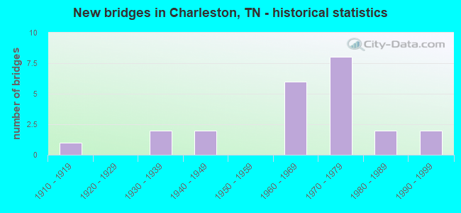
- New bridges - historical statistics
- 11910-1919
- 21930-1939
- 21940-1949
- 61960-1969
- 81970-1979
- 21980-1989
- 21990-1999


- Bridge Condition - Deck
- 61.5%Good
- 15.4%Satisfactory
- 15.4%Fair
- 7.7%Poor

- Bridge Condition - Superstructure
- 61.5%Good
- 15.4%Satisfactory
- 15.4%Fair
- 7.7%Poor

- Bridge Condition - Substructure
- 76.9%Good
- 23.1%Satisfactory

- Bridge Condition - Channel
- 7.1%Very good
- 28.6%Good
- 50.0%Satisfactory
- 14.3%Fair

- Bridge Condition - Culverts
- 80.0%Good
- 20.0%Satisfactory
Find on map >> Show street view
Structure Number: 6011600005, Location: 0.8 MI. W. OF SR 2 (Lat: 35.283950, Lng: -84.800700), Route carried "on" structure: State highway 308, Year Built: 1971, Status: Open, Structure Length: 1.80m (5.91ft), Average Daily Traffic: 5,663 (year 2020), Truck Traffic: 4%, Average Future Daily Traffic: 9,061 (year 2041), Design Load: HS 20, Features Intersected: SOUTH MOUSE CREEK
Minimum Vertical Clearance: 30+ m (98+ ft), Kilometerpoint: 8.369, Lanes on structure: 2, Owner: State Highway Agency, Approaching Roadway Width: 10.4m (34.1ft), Skew: 4 degrees, Material/Design: Concrete continuous, Design/Construction: Culvert, Number Of Spans In Main Unit: 3, Length of Maximum Span: 4.6m (15.1ft)
Condition: Channel: Fair, Culverts: Satisfactory, Operating Rating: 89.1 metric tons, Method Used To Determine Operating Rating: Load Factor (LF), Inventory Rating: 32.4 metric tons, Method Used To Determine Inventory Rating: Load Factor (LF), Structural Evaluation: Equal to present minimum criteria, Waterway Adequacy: Better than present minimum criteria, Approach Roadway Alignment: Better than present minimum criteria, Designated Inspection Frequency: Every 24 months, Inspection Date: August 2021
Find on map >> Show street view
Structure Number: 6011850001, Location: .1MI EAST OF I75 (Lat: 35.304550, Lng: -84.800367), Route carried "on" structure: County highway 1185, Year Built: 1939, Status: Posted for load, Structure Length: 4.02m (13.19ft), Average Daily Traffic: 697 (year 2020), Truck Traffic: 3%, Average Future Daily Traffic: 1,115 (year 2042), Design Load: H 10, Features Intersected: SOUTH MOUSE CREEK
Minimum Vertical Clearance: 30+ m (98+ ft), Kilometerpoint: 21.018, Lanes on structure: 2, Owner: County Highway Agency, Approaching Roadway Width: 5.5m (18.0ft), Material/Design: Steel continuous, Design/Construction: Stringer/Multi-beam, Number Of Spans In Main Unit: 3, Length of Maximum Span: 14.9m (48.9ft), Curb-To-Curb Width: 5.5m (18.0ft), Out-to-Out Width: 6.6m (21.7ft)
Condition: Deck: Fair, Superstructure: Fair, Substructure: Good, Channel: Good, Operating Rating: 14.3 metric tons, Method Used To Determine Operating Rating: Load and Resistance Factor Rating (LRFR) rating reported by rating factor(RF) method using HL-93 loadings, Inventory Rating: 11.0 metric tons, Method Used To Determine Inventory Rating: Load and Resistance Factor Rating (LRFR) rating reported by rating factor(RF) method using HL-93 loadings, Structural Evaluation: High priority of replacement, Deck Geometry: High priority of replacement, Waterway Adequacy: Superior to present desirable criteria, Approach Roadway Alignment: Equal to present minimum criteria, Bridge Posting: Required (Relationship of Operating Rating to Maximum Legal Load: 0.1 - 9.9% below), Length Of Structure Improvement: 4.98m (16.34ft), Designated Inspection Frequency: Every 24 months, Underwater Inspection Frequency: Every 60 months, Inspection Date: September 2021, Underwater Inspection Date: August 2020, Bridge Improvement Cost: $1,012,000, Roadway Improvement Cost: $102,000, Total Project Cost: $1,519,000 ( Estimate for 2022), Deck Structure Type: Concrete Cast-file-Place, Wearing Surface/Protective System: Wearing Surface: Monolithic Concrete
Find on map >> Show street view
Structure Number: 6022650009, Location: 1 MI EAST OF US 11 (Lat: 35.241817, Lng: -84.754917), Route carried "on" structure: County highway 2265, Year Built: 1940, Status: Posted for load, Structure Length: 2.62m (8.60ft), Average Daily Traffic: 257 (year 2020), Truck Traffic: 3%, Average Future Daily Traffic: 411 (year 2041), Design Load: H 15, Features Intersected: CHATATA CREEK
Minimum Vertical Clearance: 30+ m (98+ ft), Kilometerpoint: 8.723, Lanes on structure: 2, Owner: County Highway Agency, Approaching Roadway Width: 5.5m (18.0ft), Material/Design: Steel, Design/Construction: Stringer/Multi-beam, Number Of Spans In Main Unit: 2, Length of Maximum Span: 15.5m (50.9ft), Curb-To-Curb Width: 6.1m (20.0ft), Out-to-Out Width: 6.4m (21.0ft)
Condition: Deck: Fair, Superstructure: Poor, Substructure: Satisfactory, Channel: Satisfactory, Operating Rating: 17.2 metric tons, Method Used To Determine Operating Rating: Load and Resistance Factor Rating (LRFR) rating reported by rating factor(RF) method using HL-93 loadings, Inventory Rating: 13.3 metric tons, Method Used To Determine Inventory Rating: Load and Resistance Factor Rating (LRFR) rating reported by rating factor(RF) method using HL-93 loadings, Structural Evaluation: Meets minimum limits, Deck Geometry: Meets minimum limits, Waterway Adequacy: Better than present minimum criteria, Approach Roadway Alignment: Equal to present minimum criteria, Length Of Structure Improvement: 3.53m (11.58ft), Designated Inspection Frequency: Every 24 months, Inspection Date: October 2021, Bridge Improvement Cost: $701,000, Roadway Improvement Cost: $71,000, Total Project Cost: $1,052,000 ( Estimate for 2021), Deck Structure Type: Concrete Cast-file-Place, Wearing Surface/Protective System: Wearing Surface: Bituminous
Find on map >> Show street view
Structure Number: 6022760001, Location: 1MI EAST OF US11 (Lat: 35.260867, Lng: -84.744583), Route carried "on" structure: County highway 2276, Year Built: 1963, Status: Open, Structure Length: 3.87m (12.70ft), Average Daily Traffic: 1,157 (year 2020), Truck Traffic: 3%, Average Future Daily Traffic: 1,851 (year 2042), Design Load: H 10, Features Intersected: CHATATA CREEK
Minimum Vertical Clearance: 30+ m (98+ ft), Kilometerpoint: 1.513, Lanes on structure: 2, Owner: County Highway Agency, Approaching Roadway Width: 6.1m (20.0ft), Skew: 1 degrees, Material/Design: Prestressed concrete, Design/Construction: Stringer/Multi-beam, Number Of Spans In Main Unit: 3, Length of Maximum Span: 13.1m (43.0ft), Curb-To-Curb Width: 7.3m (24.0ft), Out-to-Out Width: 8.7m (28.5ft)
Condition: Deck: Good, Superstructure: Good, Substructure: Good, Channel: Fair, Operating Rating: 41.4 metric tons, Method Used To Determine Operating Rating: Load Factor (LF), Inventory Rating: 25.2 metric tons, Method Used To Determine Inventory Rating: Load Factor (LF), Structural Evaluation: Equal to present minimum criteria, Deck Geometry: Meets minimum limits, Waterway Adequacy: Superior to present desirable criteria, Approach Roadway Alignment: Better than present minimum criteria, Length Of Structure Improvement: 3.87m (12.70ft), Designated Inspection Frequency: Every 24 months, Underwater Inspection Frequency: Every 60 months, Inspection Date: September 2021, Underwater Inspection Date: August 2020, Bridge Improvement Cost: $246,000, Roadway Improvement Cost: $25,000, Total Project Cost: $370,000 ( Estimate for 2022), Deck Structure Type: Concrete Cast-file-Place, Wearing Surface/Protective System: Wearing Surface: Monolithic Concrete
Find on map >> Show street view
Structure Number: 6022760005, Location: 3MI EAST OF US11 (Lat: 35.237083, Lng: -84.719017), Route carried "on" structure: County highway 2276, Year Built: 1963, Status: Open, Structure Length: 0.76m (2.49ft), Average Daily Traffic: 731 (year 2020), Truck Traffic: 4%, Average Future Daily Traffic: 1,170 (year 2041), Design Load: HS 20, Features Intersected: PARKER BRANCH
Minimum Vertical Clearance: 30+ m (98+ ft), Kilometerpoint: 5.906, Lanes on structure: 2, Owner: County Highway Agency, Approaching Roadway Width: 7.9m (25.9ft), Skew: 3 degrees, Material/Design: Concrete continuous, Design/Construction: Culvert, Number Of Spans In Main Unit: 2, Length of Maximum Span: 3.7m (12.1ft)
Condition: Channel: Satisfactory, Culverts: Good, Operating Rating: 89.1 metric tons, Method Used To Determine Operating Rating: Load Factor (LF), Inventory Rating: 32.4 metric tons, Method Used To Determine Inventory Rating: Load Factor (LF), Structural Evaluation: Better than present minimum criteria, Waterway Adequacy: Better than present minimum criteria, Approach Roadway Alignment: Equal to present desirable criteria, Designated Inspection Frequency: Every 24 months, Inspection Date: September 2021
Find on map >> Show street view
Structure Number: 60A3920003, Location: .5MI WEST OF US11 (Lat: 35.270200, Lng: -84.781933), Route carried "on" structure: County highway 392, Year Built: 1982, Status: Open, Structure Length: 0.79m (2.59ft), Average Daily Traffic: 1,560 (year 2022), Truck Traffic: 2%, Average Future Daily Traffic: 2,496 (year 2041), Design Load: HS 20, Features Intersected: LITTLE SOUTH MOUSE CREEK
Minimum Vertical Clearance: 30+ m (98+ ft), Kilometerpoint: 4.241, Lanes on structure: 2, Owner: County Highway Agency, Approaching Roadway Width: 5.5m (18.0ft), Skew: 3 degrees, Material/Design: Concrete continuous, Design/Construction: Culvert, Number Of Spans In Main Unit: 2, Length of Maximum Span: 4.0m (13.1ft), Curb-To-Curb Width: 8.3m (27.2ft), Out-to-Out Width: 11.4m (37.4ft)
Condition: Channel: Satisfactory, Culverts: Good, Operating Rating: 54.9 metric tons, Method Used To Determine Operating Rating: Load Factor (LF), Inventory Rating: 32.4 metric tons, Method Used To Determine Inventory Rating: Load Factor (LF), Structural Evaluation: Better than present minimum criteria, Deck Geometry: Meets minimum limits, Waterway Adequacy: Better than present minimum criteria, Approach Roadway Alignment: Better than present minimum criteria, Designated Inspection Frequency: Every 24 months, Inspection Date: September 2021, Deck Structure Type: Concrete Cast-file-Place, Wearing Surface/Protective System: Wearing Surface: Bituminous
Find on map >> Show street view
Structure Number: 60A4030001, Location: .04MI WEST OF US11 (Lat: 35.256750, Lng: -84.791533), Route carried "on" structure: County highway 403, Year Built: 1987, Status: Open, Structure Length: 1.19m (3.90ft), Average Daily Traffic: 670 (year 2022), Truck Traffic: 2%, Average Future Daily Traffic: 1,072 (year 2041), Design Load: HS 20, Features Intersected: LITTLE SOUTH MOUSE CREEK
Minimum Vertical Clearance: 30+ m (98+ ft), Kilometerpoint: 0.082, Lanes on structure: 2, Owner: County Highway Agency, Approaching Roadway Width: 5.5m (18.0ft), Material/Design: Concrete continuous, Design/Construction: Culvert, Number Of Spans In Main Unit: 3, Length of Maximum Span: 3.7m (12.1ft), Curb-To-Curb Width: 7.3m (24.0ft), Out-to-Out Width: 8.4m (27.6ft)
Condition: Channel: Good, Culverts: Good, Operating Rating: 38.7 metric tons, Method Used To Determine Operating Rating: Load Factor (LF), Inventory Rating: 22.5 metric tons, Method Used To Determine Inventory Rating: Load Factor (LF), Structural Evaluation: Equal to present minimum criteria, Deck Geometry: Meets minimum limits, Waterway Adequacy: Equal to present desirable criteria, Approach Roadway Alignment: Better than present minimum criteria, Designated Inspection Frequency: Every 24 months, Inspection Date: September 2021, Deck Structure Type: Concrete Cast-file-Place, Wearing Surface/Protective System: Wearing Surface: Bituminous
Find on map >> Show street view
Structure Number: 60A4190001, Location: IN CITY OF CHARLESTON (Lat: 35.288700, Lng: -84.755117), Route carried "on" structure: City street 419, Year Built: 1940, Status: Posted for load, Structure Length: 1.86m (6.10ft), Average Daily Traffic: 1,690 (year 2022), Truck Traffic: 2%, Average Future Daily Traffic: 2,704 (year 2042), Features Intersected: BRANCH
Minimum Vertical Clearance: 30+ m (98+ ft), Kilometerpoint: 1.286, Lanes on structure: 2, Owner: City or Municipal Highway Agency, Approaching Roadway Width: 6.1m (20.0ft), Material/Design: Steel, Design/Construction: Stringer/Multi-beam, Number Of Spans In Main Unit: 3, Length of Maximum Span: 6.4m (21.0ft), Curb-To-Curb Width: 5.2m (17.1ft), Out-to-Out Width: 5.5m (18.0ft)
Condition: Deck: Poor, Superstructure: Fair, Substructure: Good, Channel: Good, Operating Rating: 5.8 metric tons, Method Used To Determine Operating Rating: Load and Resistance Factor Rating (LRFR) rating reported by rating factor(RF) method using HL-93 loadings, Inventory Rating: 4.2 metric tons, Method Used To Determine Inventory Rating: Load and Resistance Factor Rating (LRFR) rating reported by rating factor(RF) method using HL-93 loadings, Structural Evaluation: High priority of corrective action, Deck Geometry: High priority of replacement, Waterway Adequacy: Superior to present desirable criteria, Approach Roadway Alignment: Equal to present desirable criteria, Bridge Posting: Required (Relationship of Operating Rating to Maximum Legal Load: 10.0 - 19.9% below), Length Of Structure Improvement: 1.86m (6.10ft), Designated Inspection Frequency: Every 24 months, Inspection Date: September 2021, Bridge Improvement Cost: $255,000, Roadway Improvement Cost: $26,000, Total Project Cost: $383,000 ( Estimate for 2022), Deck Structure Type: Concrete Cast-file-Place, Wearing Surface/Protective System: Wearing Surface: Bituminous
Find on map >> Show street view
Structure Number: 60A4220001, Location: IN CITY OF CHARLESTON (Lat: 35.281767, Lng: -84.758400), Route carried "on" structure: City street 422, Year Built: 1935, Status: Open, Structure Length: 0.91m (2.99ft), Average Daily Traffic: 230 (year 2022), Truck Traffic: 2%, Average Future Daily Traffic: 368 (year 2041), Design Load: H 15, Features Intersected: BRANCH
Minimum Vertical Clearance: 30+ m (98+ ft), Kilometerpoint: 0.381, Lanes on structure: 2, Owner: City or Municipal Highway Agency, Approaching Roadway Width: 5.5m (18.0ft), Skew: 4 degrees, Material/Design: Concrete continuous, Design/Construction: Culvert, Number Of Spans In Main Unit: 2, Length of Maximum Span: 4.3m (14.1ft), Curb-To-Curb Width: 9.4m (30.8ft), Out-to-Out Width: 10.4m (34.1ft)
Condition: Channel: Satisfactory, Culverts: Good, Operating Rating: 45.0 metric tons, Method Used To Determine Operating Rating: Load Factor (LF), Inventory Rating: 24.3 metric tons, Method Used To Determine Inventory Rating: Load Factor (LF), Structural Evaluation: Equal to present minimum criteria, Deck Geometry: Equal to present minimum criteria, Waterway Adequacy: Better than present minimum criteria, Approach Roadway Alignment: Equal to present desirable criteria, Designated Inspection Frequency: Every 24 months, Inspection Date: September 2021, Deck Structure Type: Concrete Cast-file-Place, Wearing Surface/Protective System: Wearing Surface: Bituminous
Find on map >> Show street view
Structure Number: 6I00750025, Location: NEAR CLEVELAND TENNESSEE (Lat: 35.288967, Lng: -84.815750), Route carried "on" structure: State highway 308, Year Built: 1968, Status: Open, Structure Length: 10.39m (34.09ft), Average Daily Traffic: 2,270 (year 2020), Truck Traffic: 3%, Average Future Daily Traffic: 3,632 (year 2042), Design Load: HS 20, Features Intersected: I75
Minimum Vertical Clearance: 30+ m (98+ ft), Kilometerpoint: 6.872, Lanes on structure: 2, Lanes under structure: 4, Owner: State Highway Agency, Approaching Roadway Width: 14.6m (47.9ft), Material/Design: Concrete continuous, Design/Construction: Tee Beam, Number Of Spans In Main Unit: 5, Length of Maximum Span: 25.3m (83.0ft), Curb-To-Curb Width: 14.6m (47.9ft), Out-to-Out Width: 15.2m (49.9ft)
Condition: Deck: Good, Superstructure: Good, Substructure: Good, Operating Rating: 39.6 metric tons, Method Used To Determine Operating Rating: Load Factor (LF), Inventory Rating: 24.3 metric tons, Method Used To Determine Inventory Rating: Load Factor (LF), Structural Evaluation: Equal to present minimum criteria, Deck Geometry: Superior to present desirable criteria, Underclear: Somewhat better than minimum adequacy, Approach Roadway Alignment: Equal to present desirable criteria, Designated Inspection Frequency: Every 24 months, Inspection Date: July 2021, Deck Structure Type: Concrete Cast-file-Place, Wearing Surface/Protective System: Wearing Surface: Bituminous
Find on map >> Show street view
Structure Number: 6I00750027, Location: BRADLEY-MCMINN CO.LINE (Lat: 35.314767, Lng: -84.800500), Route carried "on" structure: Interstate 75, Year Built: 1968, Status: Open, Structure Length: 33.53m (110.01ft), Average Daily Traffic: 44,356 (year 2020), Truck Traffic: 11%, Average Future Daily Traffic: 70,970 (year 2042), Design Load: HS 20+Mod, Features Intersected: HIWASSEE RIVER
Minimum Vertical Clearance: 30+ m (98+ ft), Kilometerpoint: 30.851, Lanes on structure: 2, Base Highway Network: Yes, Owner: State Highway Agency, Approaching Roadway Width: 12.8m (42.0ft), Skew: 12 degrees, Navigation Control: Yes ( Vertical Clearance: 12.8m (42.0ft), Horizontal Clearance: 76.2m (250.0ft)), Material/Design: Steel continuous, Design/Construction: Girder and Floorbeam System, Number Of Spans In Main Unit: 6, Length of Maximum Span: 89.0m (292.0ft), Curb-To-Curb Width: 12.2m (40.0ft), Out-to-Out Width: 12.8m (42.0ft)
Condition: Deck: Good, Superstructure: Good, Substructure: Satisfactory, Channel: Satisfactory, Operating Rating: 24.6 metric tons, Method Used To Determine Operating Rating: Load and Resistance Factor Rating (LRFR) rating reported by rating factor(RF) method using HL-93 loadings, Inventory Rating: 19.1 metric tons, Method Used To Determine Inventory Rating: Load and Resistance Factor Rating (LRFR) rating reported by rating factor(RF) method using HL-93 loadings, Structural Evaluation: Meets minimum limits, Deck Geometry: Better than present minimum criteria, Waterway Adequacy: Superior to present desirable criteria, Approach Roadway Alignment: Equal to present desirable criteria, Designated Inspection Frequency: Every 24 months, Critical Feature Inspection Frequency: Every 24 months, Underwater Inspection Frequency: Every 60 months, Other Special Inspection Frequency: Every 24 months, Inspection Date: July 2021, Critical Feature Inspection Date: July 2021, Underwater Inspection Date: September 2021, Other Special Inspection Date: July 2021, Deck Structure Type: Steel plate, Wearing Surface/Protective System: Wearing Surface: Bituminous, Membrane: Preformed Fabric
Find on map >> Show street view
Structure Number: 6I00750028, Location: BRADLEY-MCMINN CO.LINE (Lat: 35.315050, Lng: -84.801050), Route carried "on" structure: Interstate 75, Year Built: 1968, Status: Open, Structure Length: 33.53m (110.01ft), Average Daily Traffic: 44,356 (year 2020), Truck Traffic: 27%, Average Future Daily Traffic: 70,970 (year 2042), Design Load: HS 20+Mod, Features Intersected: HIWASSEE RIVER
Minimum Vertical Clearance: 30+ m (98+ ft), Kilometerpoint: 30.851, Lanes on structure: 2, Base Highway Network: Yes, Owner: State Highway Agency, Approaching Roadway Width: 12.8m (42.0ft), Skew: 12 degrees, Navigation Control: Yes ( Vertical Clearance: 12.8m (42.0ft), Horizontal Clearance: 76.2m (250.0ft)), Material/Design: Steel continuous, Design/Construction: Girder and Floorbeam System, Number Of Spans In Main Unit: 6, Length of Maximum Span: 89.0m (292.0ft), Curb-To-Curb Width: 12.2m (40.0ft), Out-to-Out Width: 12.8m (42.0ft)
Condition: Deck: Good, Superstructure: Satisfactory, Substructure: Satisfactory, Channel: Satisfactory, Operating Rating: 39.6 metric tons, Method Used To Determine Operating Rating: Load Factor (LF), Inventory Rating: 24.3 metric tons, Method Used To Determine Inventory Rating: Load Factor (LF), Structural Evaluation: Equal to present minimum criteria, Deck Geometry: Better than present minimum criteria, Waterway Adequacy: Superior to present desirable criteria, Approach Roadway Alignment: Equal to present desirable criteria, Designated Inspection Frequency: Every 24 months, Critical Feature Inspection Frequency: Every 24 months, Underwater Inspection Frequency: Every 60 months, Inspection Date: July 2021, Critical Feature Inspection Date: July 2021, Underwater Inspection Date: September 2021, Deck Structure Type: Steel plate, Wearing Surface/Protective System: Wearing Surface: Bituminous
Find on map >> Show street view
Structure Number: 6I00750029, Location: .75 MI.S.OF MCMINN CO. (Lat: 35.307700, Lng: -84.806433), Route carried "on" structure: Interstate 75, Year Built: 1972, Status: Open, Structure Length: 3.84m (12.60ft), Average Daily Traffic: 44,356 (year 2020), Truck Traffic: 27%, Average Future Daily Traffic: 70,970 (year 2041), Design Load: HS 20+Mod, Features Intersected: OLD LOWER RIVER RD 1185
Minimum Vertical Clearance: 30+ m (98+ ft), Kilometerpoint: 29.870, Lanes on structure: 2, Lanes under structure: 2, Base Highway Network: Yes, Owner: State Highway Agency, Approaching Roadway Width: 12.8m (42.0ft), Material/Design: Concrete continuous, Design/Construction: Tee Beam, Number Of Spans In Main Unit: 3, Length of Maximum Span: 15.8m (51.8ft), Curb-To-Curb Width: 12.8m (42.0ft), Out-to-Out Width: 13.4m (44.0ft)
Condition: Deck: Good, Superstructure: Good, Substructure: Good, Operating Rating: 79.2 metric tons, Method Used To Determine Operating Rating: Load Factor (LF), Inventory Rating: 32.4 metric tons, Method Used To Determine Inventory Rating: Load Factor (LF), Structural Evaluation: Better than present minimum criteria, Deck Geometry: Equal to present desirable criteria, Underclear: Superior to present desirable criteria, Approach Roadway Alignment: Equal to present desirable criteria, Designated Inspection Frequency: Every 24 months, Inspection Date: July 2021, Deck Structure Type: Concrete Cast-file-Place, Wearing Surface/Protective System: Wearing Surface: Bituminous
Find on map >> Show street view
Structure Number: 6I0075003, Location: .75 MI.S.OF MCMINN CO. (Lat: 35.308117, Lng: -84.807317), Route carried "on" structure: Interstate 75, Year Built: 1972, Status: Open, Structure Length: 3.84m (12.60ft), Average Daily Traffic: 44,356 (year 2020), Truck Traffic: 27%, Average Future Daily Traffic: 70,970 (year 2041), Design Load: HS 20+Mod, Features Intersected: EUREKA RD (NFA 1185)
Minimum Vertical Clearance: 30+ m (98+ ft), Kilometerpoint: 29.870, Lanes on structure: 2, Lanes under structure: 2, Base Highway Network: Yes, Owner: State Highway Agency, Approaching Roadway Width: 12.8m (42.0ft), Material/Design: Concrete continuous, Design/Construction: Tee Beam, Number Of Spans In Main Unit: 3, Length of Maximum Span: 15.8m (51.8ft), Curb-To-Curb Width: 12.8m (42.0ft), Out-to-Out Width: 13.4m (44.0ft)
Condition: Deck: Satisfactory, Superstructure: Good, Substructure: Good, Operating Rating: 79.2 metric tons, Method Used To Determine Operating Rating: Load Factor (LF), Inventory Rating: 32.4 metric tons, Method Used To Determine Inventory Rating: Load Factor (LF), Structural Evaluation: Better than present minimum criteria, Deck Geometry: Equal to present desirable criteria, Underclear: Equal to present minimum criteria, Approach Roadway Alignment: Equal to present desirable criteria, Designated Inspection Frequency: Every 24 months, Inspection Date: July 2021, Deck Structure Type: Concrete Cast-file-Place, Wearing Surface/Protective System: Wearing Surface: Bituminous
Find on map >> Show street view
Structure Number: 6SR0020015, Location: IN CHARLESTON CITY LIMITS (Lat: 35.289867, Lng: -84.757050), Route carried "on" structure: US 11, Year Built: 1995, Status: Open, Structure Length: 28.25m (92.68ft), Average Daily Traffic: 7,525 (year 2020), Truck Traffic: 4%, Average Future Daily Traffic: 12,040 (year 2042), Design Load: HS 20, Features Intersected: HIWASSEE RIVER & SOU RR, Facility Carried by Structure: FAP 2 731613W
Minimum Vertical Clearance: 30+ m (98+ ft), Kilometerpoint: 33.668, Lanes on structure: 3, Owner: State Highway Agency, Approaching Roadway Width: 25.9m (85.0ft), Skew: 1 degrees, Navigation Control: Yes ( Vertical Clearance: 12.8m (42.0ft), Horizontal Clearance: 57.9m (190.0ft)), Material/Design: Steel continuous, Design/Construction: Stringer/Multi-beam, Number Of Spans In Main Unit: 7, Length of Maximum Span: 62.5m (205.1ft), Curb or Sidewalk Widths: Left: 1.5m (4.9ft), Right: 0.0m, Curb-To-Curb Width: 21.0m (68.9ft), Out-to-Out Width: 21.0m (68.9ft)
Condition: Deck: Good, Superstructure: Good, Substructure: Good, Channel: Satisfactory, Operating Rating: 59.4 metric tons, Method Used To Determine Operating Rating: Load Factor (LF), Inventory Rating: 32.4 metric tons, Method Used To Determine Inventory Rating: Load Factor (LF), Structural Evaluation: Better than present minimum criteria, Deck Geometry: Superior to present desirable criteria, Underclear: Meets minimum limits, Waterway Adequacy: Superior to present desirable criteria, Approach Roadway Alignment: Equal to present desirable criteria, Length Of Structure Improvement: 28.25m (92.68ft), Designated Inspection Frequency: Every 24 months, Underwater Inspection Frequency: Every 60 months, Inspection Date: July 2021, Underwater Inspection Date: June 2017, Bridge Improvement Cost: $15,682,000, Roadway Improvement Cost: $1,569,000, Total Project Cost: $23,524,000 ( Estimate for 2022), Deck Structure Type: Concrete Cast-file-Place, Wearing Surface/Protective System: Wearing Surface: Monolithic Concrete, Deck Protection: Epoxy Coated Reinforcing
Find on map >> Show street view
Structure Number: 540A4880001, Location: 2MI WEST OF I75 (Lat: 35.340850, Lng: -84.779817), Route carried "on" structure: County highway 488, Year Built: 1970, Status: Open, Structure Length: 1.83m (6.00ft), Average Daily Traffic: 370 (year 2022), Truck Traffic: 2%, Average Future Daily Traffic: 592 (year 2039), Features Intersected: SPRING CREEK
Minimum Vertical Clearance: 30+ m (98+ ft), Kilometerpoint: 3.170, Lanes on structure: 2, Owner: County Highway Agency, Approaching Roadway Width: 5.8m (19.0ft), Skew: 1 degrees, Material/Design: Steel continuous, Design/Construction: Stringer/Multi-beam, Number Of Spans In Main Unit: 2, Length of Maximum Span: 9.1m (29.9ft), Curb-To-Curb Width: 6.6m (21.7ft), Out-to-Out Width: 6.7m (22.0ft)
Condition: Deck: Good, Superstructure: Good, Substructure: Good, Channel: Good, Operating Rating: 36.0 metric tons, Method Used To Determine Operating Rating: Allowable Stress (AS), Inventory Rating: 24.3 metric tons, Method Used To Determine Inventory Rating: Allowable Stress (AS), Structural Evaluation: Equal to present minimum criteria, Deck Geometry: Meets minimum limits, Waterway Adequacy: Better than present minimum criteria, Approach Roadway Alignment: High priority of corrective action, Length Of Structure Improvement: 1.83m (6.00ft), Designated Inspection Frequency: Every 24 months, Inspection Date: September 2021, Bridge Improvement Cost: $133,000, Roadway Improvement Cost: $14,000, Total Project Cost: $200,000 ( Estimate for 2019), Deck Structure Type: Corrugated Steel, Wearing Surface/Protective System: Wearing Surface: Bituminous
Find on map >> Show street view
Structure Number: 54I00750001, Location: 1.1 MI S BRAD MCMINN C L (Lat: 35.324883, Lng: -84.782833), Route carried "on" structure: County highway 947, Year Built: 1972, Status: Open, Structure Length: 10.36m (33.99ft), Average Daily Traffic: 2,084 (year 2020), Truck Traffic: 3%, Average Future Daily Traffic: 3,088 (year 2040), Design Load: H 20, Features Intersected: I75
Minimum Vertical Clearance: 30+ m (98+ ft), Kilometerpoint: 9.753, Lanes on structure: 2, Lanes under structure: 4, Owner: State Highway Agency, Approaching Roadway Width: 14.6m (47.9ft), Skew: 3 degrees, Material/Design: Prestressed concrete, Design/Construction: Box Beam or Girders - Multiple, Number Of Spans In Main Unit: 3, Length of Maximum Span: 36.6m (120.1ft), Curb-To-Curb Width: 14.4m (47.2ft), Out-to-Out Width: 15.2m (49.9ft)
Condition: Deck: Satisfactory, Superstructure: Satisfactory, Substructure: Good, Operating Rating: 42.8 metric tons, Method Used To Determine Operating Rating: Load and Resistance Factor Rating (LRFR) rating reported by rating factor(RF) method using HL-93 loadings, Inventory Rating: 33.0 metric tons, Method Used To Determine Inventory Rating: Load and Resistance Factor Rating (LRFR) rating reported by rating factor(RF) method using HL-93 loadings, Structural Evaluation: Equal to present minimum criteria, Deck Geometry: Superior to present desirable criteria, Underclear: Somewhat better than minimum adequacy, Approach Roadway Alignment: Equal to present desirable criteria, Designated Inspection Frequency: Every 24 months, Inspection Date: April 2020, Deck Structure Type: Concrete Cast-file-Place, Wearing Surface/Protective System: Wearing Surface: Bituminous
Find on map >> Show street view
Structure Number: 54S42740003, Location: .5MIWEST OF I75 (Lat: 35.327558, Lng: -84.789575), Route carried "on" structure: County highway 947, Year Built: 1995, Status: Open, Structure Length: 7.62m (25.00ft), Average Daily Traffic: 2,084 (year 2020), Truck Traffic: 3%, Average Future Daily Traffic: 3,088 (year 2040), Design Load: HS 20, Features Intersected: NORTH MOUSE CREEK
Minimum Vertical Clearance: 30+ m (98+ ft), Kilometerpoint: 8.996, Lanes on structure: 2, Owner: County Highway Agency, Approaching Roadway Width: 8.8m (28.9ft), Material/Design: Prestressed concrete continuous, Design/Construction: Stringer/Multi-beam, Number Of Spans In Main Unit: 3, Length of Maximum Span: 25.3m (83.0ft), Curb-To-Curb Width: 9.8m (32.2ft), Out-to-Out Width: 10.4m (34.1ft)
Condition: Deck: Good, Superstructure: Good, Substructure: Good, Channel: Very good, Operating Rating: 74.8 metric tons, Method Used To Determine Operating Rating: Load and Resistance Factor Rating (LRFR) rating reported by rating factor(RF) method using HL-93 loadings, Inventory Rating: 46.7 metric tons, Method Used To Determine Inventory Rating: Load and Resistance Factor Rating (LRFR) rating reported by rating factor(RF) method using HL-93 loadings, Structural Evaluation: Better than present minimum criteria, Deck Geometry: Meets minimum limits, Waterway Adequacy: Better than present minimum criteria, Approach Roadway Alignment: Equal to present minimum criteria, Designated Inspection Frequency: Every 24 months, Underwater Inspection Frequency: Every 60 months, Inspection Date: July 2021, Underwater Inspection Date: September 2019, Deck Structure Type: Concrete Cast-file-Place, Wearing Surface/Protective System: Wearing Surface: Monolithic Concrete, Deck Protection: Epoxy Coated Reinforcing
Find on map >> Show street view
Structure Number: 60A4220003, Location: IN CITY OF CHARLESTON (Lat: 35.287883, Lng: -84.753333), Route carried "under" structure: City street 422, Year Built: 1919, Structure Length: 0. m, Average Daily Traffic: 1,310 (year 2022), Truck Traffic: 5%, Features Intersected: NORFOLK SOUTHERN RR, Facility Carried by Structure: SOU RWY 731610B
Minimum Vertical Clearance: 4.47m (14.67ft), Kilometerpoint: 1.276, Lanes under structure: 2, Material/Design: Steel, Design/Construction: Stringer/Multi-beam, Length of Maximum Span: 8.8m (28.9ft)
Find on map >> Show street view
Structure Number: 6I00750025, Location: NEAR CLEVELAND (Lat: 35.288650, Lng: -84.814783), Route carried "under" structure: Interstate 75, Year Built: 1968, Structure Length: 0. m, Average Daily Traffic: 45,359 (year 2020), Truck Traffic: 27%, Features Intersected: SR 308, Facility Carried by Structure: FAS 308
Minimum Vertical Clearance: 5.92m (19.42ft), Kilometerpoint: 27.616, Lanes on structure: 2, Lanes under structure: 4, Material/Design: Concrete continuous, Design/Construction: Tee Beam, Length of Maximum Span: 25.3m (83.0ft)
Find on map >> Show street view
Structure Number: 6I00750029, Location: 1.1 MI FROM HIWA RIVER (Lat: 35.307800, Lng: -84.806483), Route carried "under" structure: County highway 1185, Year Built: 1972, Structure Length: 0. m, Average Daily Traffic: 697 (year 2020), Truck Traffic: 3%, Features Intersected: I75 / NFA 1185, Facility Carried by Structure: I75 (SA 0610)
Minimum Vertical Clearance: 5.05m (16.57ft), Kilometerpoint: 21.775, Lanes on structure: 2, Lanes under structure: 2, Material/Design: Concrete continuous, Design/Construction: Tee Beam, Length of Maximum Span: 15.8m (51.8ft)
Find on map >> Show street view
Structure Number: 6I0075003, Location: 1.1 MI FROM HIWA RIVER (Lat: 35.308067, Lng: -84.807383), Route carried "under" structure: County highway 1185, Year Built: 1972, Structure Length: 0. m, Average Daily Traffic: 697 (year 2020), Truck Traffic: 3%, Features Intersected: I75 / NFA 1185, Facility Carried by Structure: I75 (SR 0610)
Minimum Vertical Clearance: 4.65m (15.26ft), Kilometerpoint: 21.694, Lanes on structure: 2, Lanes under structure: 2, Material/Design: Concrete continuous, Design/Construction: Tee Beam, Length of Maximum Span: 15.8m (51.8ft)
Find on map >> Show street view
Structure Number: 54I00750001, Location: 1.1 MI NE OF BRADLEY C LN (Lat: 35.323333, Lng: -84.783333), Route carried "under" structure: Interstate 75, Year Built: 1972, Structure Length: 0. m, Average Daily Traffic: 44,356 (year 2020), Truck Traffic: 35%, Features Intersected: NFA 947, Facility Carried by Structure: NFA 947
Minimum Vertical Clearance: 4.80m (15.75ft), Kilometerpoint: 1.770, Lanes on structure: 2, Lanes under structure: 4, Material/Design: Concrete continuous, Design/Construction: Box Beam or Girders - Multiple, Length of Maximum Span: 36.6m (120.1ft)