Bridge Statistics for Charlotte, Michigan (MI)
Condition, Traffic, Stress, Structural Evaluation, Project Costs
- National Bridge Inventory (NBI) Statistics
- 41Number of bridges
- 407ft / 124mTotal length
- $870,000Total costs
- 353,337Total average daily traffic
- 55,847Total average daily truck traffic
- National Bridge Inventory (NBI) Registered Bridges for Charlotte
- No street view available for this location
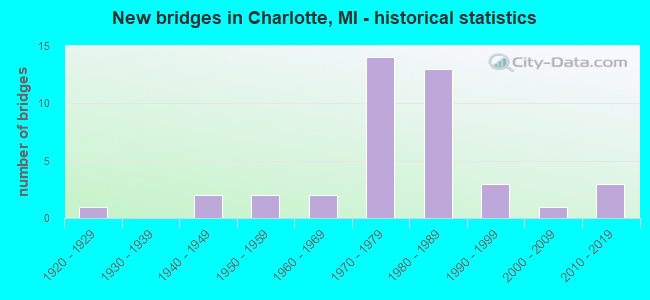
- New bridges - historical statistics
- 11920-1929
- 21940-1949
- 21950-1959
- 21960-1969
- 141970-1979
- 131980-1989
- 31990-1999
- 12000-2009
- 32010-2019
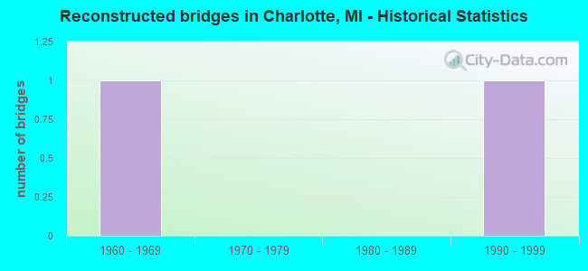
- Reconstructed bridges - Historical Statistics
- 11960-1969
- 01970-1979
- 01980-1989
- 11990-1999
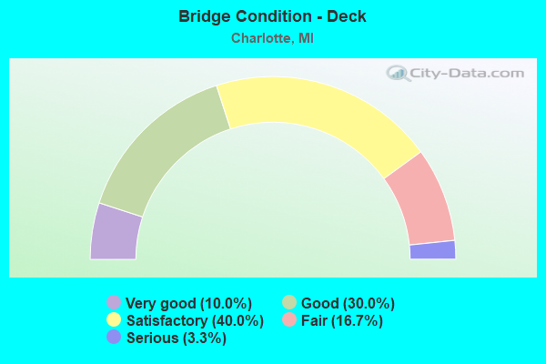
- Bridge Condition - Deck
- 10.0%Very good
- 30.0%Good
- 40.0%Satisfactory
- 16.7%Fair
- 3.3%Serious
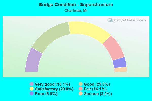
- Bridge Condition - Superstructure
- 16.1%Very good
- 29.0%Good
- 29.0%Satisfactory
- 16.1%Fair
- 6.5%Poor
- 3.2%Serious
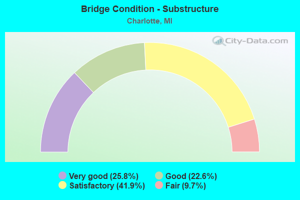
- Bridge Condition - Substructure
- 25.8%Very good
- 22.6%Good
- 41.9%Satisfactory
- 9.7%Fair

- Bridge Condition - Channel
- 5.3%Very good
- 47.4%Good
- 36.8%Satisfactory
- 5.3%Fair
- 5.3%Poor
Find on map >> Show street view
Structure Number: 2219, Location: 3.0 MI W OF CHARLOTTE (Lat: 42.568172, Lng: -84.900122), Route carried "on" structure: State highway 79, Year Built: 1946, Year Reconstructed: 1990, Status: Open, Structure Length: 0.70m (2.30ft), Average Daily Traffic: 5,470 (year 2007), Truck Traffic: 3%, Average Future Daily Traffic: 7,585 (year 2018), Design Load: HS 25 or greater, Features Intersected: LITTLE THORNAPPLE RIVER
Minimum Vertical Clearance: 30.48m (100.00ft), Kilometerpoint: 14.337, Lanes on structure: 2, Base Highway Network: Yes (Inventory Route: 56, Subroute: 4), Owner: State Highway Agency, Approaching Roadway Width: 12.8m (42.0ft), Material/Design: Prestressed concrete, Design/Construction: Box Beam or Girders - Multiple, Number Of Spans In Main Unit: 1, Length of Maximum Span: 7.0m (23.0ft), Curb-To-Curb Width: 13.4m (44.0ft), Out-to-Out Width: 15.1m (49.5ft)
Condition: Deck: Fair, Superstructure: Good, Substructure: Satisfactory, Channel: Satisfactory, Operating Rating: 97.2 metric tons, Method Used To Determine Operating Rating: Load Factor (LF) rating reported by rating factor (RF) method using MS18 loading, Inventory Rating: 61.6 metric tons, Method Used To Determine Inventory Rating: Load Factor (LF) rating reported by rating factor (RF) method using MS18 loading, Structural Evaluation: Equal to present minimum criteria, Deck Geometry: Equal to present minimum criteria, Waterway Adequacy: Equal to present desirable criteria, Approach Roadway Alignment: Equal to present desirable criteria, Designated Inspection Frequency: Every 24 months, Inspection Date: April 2021, Deck Structure Type: Concrete Cast-file-Place, Wearing Surface/Protective System: Wearing Surface: Latex Concrete
Find on map >> Show street view
Structure Number: 2222, Location: IN CHARLOTTE (Lat: 42.544647, Lng: -84.835814), Route carried "on" structure: Business Interstate 69, Year Built: 1921, Status: Open, Structure Length: 1.37m (4.49ft), Average Daily Traffic: 7,067 (year 2007), Truck Traffic: 4%, Average Future Daily Traffic: 12,003 (year 2018), Design Load: H 15, Features Intersected: BATTLE CREEK RIVER
Minimum Vertical Clearance: 30.48m (100.00ft), Kilometerpoint: 3.533, Lanes on structure: 2, Base Highway Network: Yes (Inventory Route: 56, Subroute: 3), Owner: State Highway Agency, Approaching Roadway Width: 10.2m (33.5ft), Material/Design: Concrete, Design/Construction: Arch - Deck, Number Of Spans In Main Unit: 1, Length of Maximum Span: 13.7m (44.9ft), Curb or Sidewalk Widths: Left: 0.0m, Right: 1.3m (4.3ft), Curb-To-Curb Width: 8.2m (26.9ft), Out-to-Out Width: 10.6m (34.8ft)
Condition: Superstructure: Poor, Substructure: Fair, Channel: Satisfactory, Operating Rating: 65.1 metric tons, Method Used To Determine Operating Rating: Load Factor (LF) rating reported by rating factor (RF) method using MS18 loading, Inventory Rating: 38.9 metric tons, Method Used To Determine Inventory Rating: Load Factor (LF) rating reported by rating factor (RF) method using MS18 loading, Structural Evaluation: Meets minimum limits, Deck Geometry: High priority of replacement, Waterway Adequacy: Equal to present desirable criteria, Approach Roadway Alignment: Equal to present desirable criteria, Designated Inspection Frequency: Every 12 months, Inspection Date: April 2021, Deck Structure Type: Concrete Cast-file-Place, Wearing Surface/Protective System: Wearing Surface: Bituminous
Find on map >> Show street view
Structure Number: 2229, Location: 6.4 MI NW OF CHARLOTTE (Lat: 42.638453, Lng: -84.882031), Route carried "on" structure: State highway 50, Year Built: 2013, Status: Open, Structure Length: 2.70m (8.86ft), Average Daily Traffic: 2,842 (year 2013), Truck Traffic: 17%, Average Future Daily Traffic: 3,350 (year 2032), Design Load: Greater than HL93, Features Intersected: LITTLE THORNAPPLE RIVER
Minimum Vertical Clearance: 30.48m (100.00ft), Kilometerpoint: 21.016, Lanes on structure: 2, Base Highway Network: Yes (Inventory Route: 56, Subroute: 4), Owner: State Highway Agency, Approaching Roadway Width: 13.4m (44.0ft), Skew: 3 degrees, Material/Design: Prestressed concrete, Design/Construction: Box Beam or Girders - Multiple, Number Of Spans In Main Unit: 1, Length of Maximum Span: 26.6m (87.3ft), Curb-To-Curb Width: 13.4m (44.0ft), Out-to-Out Width: 14.3m (46.9ft)
Condition: Deck: Good, Superstructure: Good, Substructure: Good, Channel: Satisfactory, Operating Rating: 82.3 metric tons, Method Used To Determine Operating Rating: Load and Resistance Factor Rating (LRFR) rating reported by rating factor(RF) method using HL-93 loadings, Inventory Rating: 46.7 metric tons, Method Used To Determine Inventory Rating: Load and Resistance Factor Rating (LRFR) rating reported by rating factor(RF) method using HL-93 loadings, Structural Evaluation: Better than present minimum criteria, Deck Geometry: Better than present minimum criteria, Waterway Adequacy: Equal to present desirable criteria, Approach Roadway Alignment: Equal to present desirable criteria, Designated Inspection Frequency: Every 24 months, Inspection Date: June 2021, Deck Structure Type: Concrete Cast-file-Place, Wearing Surface/Protective System: Wearing Surface: Monolithic Concrete, Deck Protection: Epoxy Coated Reinforcing
Find on map >> Show street view
Structure Number: 2243, Location: 0.5 MI S OF M-50 (Lat: 42.547283, Lng: -84.821183), Route carried "on" structure: Interstate 69, Year Built: 1971, Status: Open, Structure Length: 1.22m (4.00ft), Average Daily Traffic: 10,332 (year 2007), Truck Traffic: 25%, Average Future Daily Traffic: 15,614 (year 2018), Design Load: HS 20+Mod, Features Intersected: BATTLE CREEK RIVER
Minimum Vertical Clearance: 30.48m (100.00ft), Kilometerpoint: 19.273, Lanes on structure: 3, Base Highway Network: Yes (Inventory Route: 56, Subroute: 1), Owner: State Highway Agency, Approaching Roadway Width: 15.2m (49.9ft), Skew: 1 degrees, Material/Design: Prestressed concrete, Design/Construction: Stringer/Multi-beam, Number Of Spans In Main Unit: 1, Length of Maximum Span: 12.2m (40.0ft), Curb-To-Curb Width: 13.4m (44.0ft), Out-to-Out Width: 14.4m (47.2ft)
Condition: Deck: Satisfactory, Superstructure: Very good, Substructure: Satisfactory, Channel: Satisfactory, Operating Rating: 51.5 metric tons, Method Used To Determine Operating Rating: Load Factor (LF) rating reported by rating factor (RF) method using MS18 loading, Inventory Rating: 30.8 metric tons, Method Used To Determine Inventory Rating: Load Factor (LF) rating reported by rating factor (RF) method using MS18 loading, Structural Evaluation: Equal to present minimum criteria, Deck Geometry: High priority of replacement, Waterway Adequacy: Equal to present desirable criteria, Approach Roadway Alignment: Equal to present desirable criteria, Designated Inspection Frequency: Every 24 months, Inspection Date: May 2021, Deck Structure Type: Concrete Cast-file-Place, Wearing Surface/Protective System: Wearing Surface: Monolithic Concrete
Find on map >> Show street view
Structure Number: 2249, Location: E LTS OF CHARLOTTE (Lat: 42.557428, Lng: -84.820736), Route carried "on" structure: Interstate 69, Year Built: 1961, Year Reconstructed: 1971, Status: Open, Structure Length: 4.39m (14.40ft), Average Daily Traffic: 11,202 (year 2015), Truck Traffic: 21%, Average Future Daily Traffic: 17,893 (year 2018), Design Load: HS 20+Mod, Features Intersected: CHARLOTTE SOUTHERN RR
Minimum Vertical Clearance: 30.48m (100.00ft), Kilometerpoint: 20.372, Lanes on structure: 3, Base Highway Network: Yes (Inventory Route: 56, Subroute: 1), Owner: State Highway Agency, Approaching Roadway Width: 17.1m (56.1ft), Skew: 1 degrees, Material/Design: Prestressed concrete, Design/Construction: Box Beam or Girders - Multiple, Number Of Spans In Main Unit: 3, Length of Maximum Span: 14.6m (47.9ft), Curb-To-Curb Width: 16.5m (54.1ft), Out-to-Out Width: 17.6m (57.7ft)
Condition: Deck: Fair, Superstructure: Poor, Substructure: Fair, Operating Rating: 68.7 metric tons, Method Used To Determine Operating Rating: Load Factor (LF) rating reported by rating factor (RF) method using MS18 loading, Inventory Rating: 41.1 metric tons, Method Used To Determine Inventory Rating: Load Factor (LF) rating reported by rating factor (RF) method using MS18 loading, Structural Evaluation: Meets minimum limits, Deck Geometry: Equal to present minimum criteria, Approach Roadway Alignment: Equal to present minimum criteria, Designated Inspection Frequency: Every 6 months, Inspection Date: October 2021, Deck Structure Type: Concrete Cast-file-Place, Wearing Surface/Protective System: Wearing Surface: Latex Concrete
Find on map >> Show street view
Structure Number: 225, Location: E LTS OF CHARLOTTE (Lat: 42.557508, Lng: -84.821139), Route carried "on" structure: Interstate 69, Year Built: 1971, Status: Open, Structure Length: 4.39m (14.40ft), Average Daily Traffic: 14,166 (year 2007), Truck Traffic: 21%, Average Future Daily Traffic: 17,893 (year 2018), Design Load: HS 20+Mod, Features Intersected: CHARLOTTE SOUTHERN RR
Minimum Vertical Clearance: 30.48m (100.00ft), Kilometerpoint: 20.407, Lanes on structure: 3, Base Highway Network: Yes (Inventory Route: 56, Subroute: 1), Owner: State Highway Agency, Approaching Roadway Width: 18.9m (62.0ft), Skew: 1 degrees, Material/Design: Steel, Design/Construction: Stringer/Multi-beam, Number Of Spans In Main Unit: 3, Length of Maximum Span: 14.6m (47.9ft), Curb-To-Curb Width: 17.7m (58.1ft), Out-to-Out Width: 19.2m (63.0ft)
Condition: Deck: Satisfactory, Superstructure: Fair, Substructure: Satisfactory, Operating Rating: 50.5 metric tons, Method Used To Determine Operating Rating: Load and Resistance Factor Rating (LRFR) rating reported by rating factor(RF) method using HL-93 loadings, Inventory Rating: 38.9 metric tons, Method Used To Determine Inventory Rating: Load and Resistance Factor Rating (LRFR) rating reported by rating factor(RF) method using HL-93 loadings, Structural Evaluation: Somewhat better than minimum adequacy, Deck Geometry: Better than present minimum criteria, Approach Roadway Alignment: Equal to present desirable criteria, Designated Inspection Frequency: Every 24 months, Inspection Date: May 2021, Bridge Improvement Cost: $225,000, Deck Structure Type: Concrete Cast-file-Place, Wearing Surface/Protective System: Wearing Surface: Latex Concrete
Find on map >> Show street view
Structure Number: 2255, Location: 3.0 MI S OF CHARLOTTE (Lat: 42.515594, Lng: -84.835867), Route carried "on" structure: Business Interstate 69, Year Built: 1971, Status: Open, Structure Length: 15.30m (50.20ft), Average Daily Traffic: 4,139 (year 2007), Truck Traffic: 10%, Average Future Daily Traffic: 4,675 (year 2018), Design Load: HS 20+Mod, Features Intersected: I-69
Minimum Vertical Clearance: 30.48m (100.00ft), Kilometerpoint: 0.306, Lanes on structure: 2, Lanes under structure: 4, Base Highway Network: Yes (Inventory Route: 56, Subroute: 3), Owner: State Highway Agency, Approaching Roadway Width: 14.6m (47.9ft), Skew: 4 degrees, Material/Design: Steel, Design/Construction: Stringer/Multi-beam, Number Of Spans In Main Unit: 5, Length of Maximum Span: 40.8m (133.9ft), Curb or Sidewalk Widths: Left: 0.2m (0.7ft), Right: 0.2m (0.7ft), Curb-To-Curb Width: 14.6m (47.9ft), Out-to-Out Width: 15.8m (51.8ft)
Condition: Deck: Satisfactory, Superstructure: Fair, Substructure: Satisfactory, Operating Rating: 81.3 metric tons, Method Used To Determine Operating Rating: Load Factor (LF) rating reported by rating factor (RF) method using MS18 loading, Inventory Rating: 48.6 metric tons, Method Used To Determine Inventory Rating: Load Factor (LF) rating reported by rating factor (RF) method using MS18 loading, Structural Evaluation: Somewhat better than minimum adequacy, Deck Geometry: Superior to present desirable criteria, Underclear: Equal to present minimum criteria, Approach Roadway Alignment: Equal to present desirable criteria, Designated Inspection Frequency: Every 24 months, Inspection Date: May 2021, Deck Structure Type: Concrete Cast-file-Place, Wearing Surface/Protective System: Wearing Surface: Latex Concrete
Find on map >> Show street view
Structure Number: 2256, Location: 1.5 MI SE OF CHARLOTTE (Lat: 42.538583, Lng: -84.820739), Route carried "on" structure: County highway , Year Built: 1971, Status: Open, Structure Length: 8.20m (26.90ft), Average Daily Traffic: 160 (year 1988), Truck Traffic: 3%, Average Future Daily Traffic: 120 (year 1977), Design Load: H 15, Features Intersected: I-69, Facility Carried by Structure: KALAMO ROAD
Minimum Vertical Clearance: 30.48m (100.00ft), Kilometerpoint: 1.241, Lanes on structure: 2, Lanes under structure: 4, Owner: State Highway Agency, Approaching Roadway Width: 9.2m (30.2ft), Material/Design: Steel, Design/Construction: Stringer/Multi-beam, Number Of Spans In Main Unit: 2, Length of Maximum Span: 42.0m (137.8ft), Curb or Sidewalk Widths: Left: 0.2m (0.7ft), Right: 0.2m (0.7ft), Curb-To-Curb Width: 10.4m (34.1ft), Out-to-Out Width: 11.7m (38.4ft)
Condition: Deck: Satisfactory, Superstructure: Good, Substructure: Good, Operating Rating: 56.4 metric tons, Method Used To Determine Operating Rating: Load Factor (LF) rating reported by rating factor (RF) method using MS18 loading, Inventory Rating: 33.7 metric tons, Method Used To Determine Inventory Rating: Load Factor (LF) rating reported by rating factor (RF) method using MS18 loading, Structural Evaluation: Better than present minimum criteria, Deck Geometry: Better than present minimum criteria, Underclear: Somewhat better than minimum adequacy, Approach Roadway Alignment: Equal to present desirable criteria, Designated Inspection Frequency: Every 24 months, Inspection Date: May 2021, Deck Structure Type: Concrete Cast-file-Place, Wearing Surface/Protective System: Wearing Surface: Monolithic Concrete
Find on map >> Show street view
Structure Number: 2257, Location: E LTS OF CHARLOTTE (Lat: 42.553128, Lng: -84.820753), Route carried "on" structure: State highway 50, Year Built: 1971, Status: Open, Structure Length: 7.19m (23.59ft), Average Daily Traffic: 12,000 (year 2013), Truck Traffic: 4%, Average Future Daily Traffic: 13,900 (year 2030), Design Load: HS 20, Features Intersected: I-69
Minimum Vertical Clearance: 30.48m (100.00ft), Kilometerpoint: 1.238, Lanes on structure: 2, Lanes under structure: 4, Base Highway Network: Yes (Inventory Route: 56, Subroute: 10), Owner: State Highway Agency, Approaching Roadway Width: 13.5m (44.3ft), Material/Design: Steel, Design/Construction: Stringer/Multi-beam, Number Of Spans In Main Unit: 2, Length of Maximum Span: 34.7m (113.8ft), Curb-To-Curb Width: 14.2m (46.6ft), Out-to-Out Width: 15.4m (50.5ft)
Condition: Deck: Satisfactory, Superstructure: Satisfactory, Substructure: Good, Operating Rating: 80.0 metric tons, Method Used To Determine Operating Rating: Load Factor (LF) rating reported by rating factor (RF) method using MS18 loading, Inventory Rating: 48.0 metric tons, Method Used To Determine Inventory Rating: Load Factor (LF) rating reported by rating factor (RF) method using MS18 loading, Structural Evaluation: Equal to present minimum criteria, Deck Geometry: Superior to present desirable criteria, Underclear: Somewhat better than minimum adequacy, Approach Roadway Alignment: Equal to present desirable criteria, Designated Inspection Frequency: Every 24 months, Inspection Date: May 2021, Deck Structure Type: Concrete Cast-file-Place, Wearing Surface/Protective System: Wearing Surface: Epoxy Overlay
Find on map >> Show street view
Structure Number: 2258, Location: 1.8 MI N OF M-50 (Lat: 42.568003, Lng: -84.820747), Route carried "on" structure: County highway 2039, Year Built: 1971, Status: Open, Structure Length: 7.07m (23.20ft), Average Daily Traffic: 2,050 (year 1988), Truck Traffic: 3%, Average Future Daily Traffic: 1,990 (year 1977), Design Load: H 20, Features Intersected: I-69, Facility Carried by Structure: ISLAND HIGHWAY
Minimum Vertical Clearance: 30.48m (100.00ft), Kilometerpoint: 1.049, Lanes on structure: 2, Lanes under structure: 4, Owner: State Highway Agency, Approaching Roadway Width: 13.1m (43.0ft), Skew: 1 degrees, Material/Design: Steel, Design/Construction: Stringer/Multi-beam, Number Of Spans In Main Unit: 2, Length of Maximum Span: 35.3m (115.8ft), Curb or Sidewalk Widths: Left: 0.2m (0.7ft), Right: 0.2m (0.7ft), Curb-To-Curb Width: 12.3m (40.4ft), Out-to-Out Width: 13.5m (44.3ft)
Condition: Deck: Satisfactory, Superstructure: Satisfactory, Substructure: Satisfactory, Operating Rating: 61.9 metric tons, Method Used To Determine Operating Rating: Load Factor (LF) rating reported by rating factor (RF) method using MS18 loading, Inventory Rating: 36.9 metric tons, Method Used To Determine Inventory Rating: Load Factor (LF) rating reported by rating factor (RF) method using MS18 loading, Structural Evaluation: Equal to present minimum criteria, Deck Geometry: Equal to present minimum criteria, Underclear: Somewhat better than minimum adequacy, Approach Roadway Alignment: Equal to present desirable criteria, Designated Inspection Frequency: Every 24 months, Inspection Date: May 2021, Deck Structure Type: Concrete Cast-file-Place, Wearing Surface/Protective System: Wearing Surface: Monolithic Concrete
Find on map >> Show street view
Structure Number: 226, Location: 5.6 MI NE OF OLIVET (Lat: 42.509603, Lng: -84.843917), Route carried "on" structure: County highway 2324, Year Built: 1972, Status: Open, Structure Length: 15.94m (52.30ft), Average Daily Traffic: 250 (year 1988), Truck Traffic: 3%, Average Future Daily Traffic: 130 (year 1977), Design Load: H 20, Features Intersected: I-69, Facility Carried by Structure: FIVE POINT HIGHWAY
Minimum Vertical Clearance: 30.48m (100.00ft), Kilometerpoint: 18.888, Lanes on structure: 2, Lanes under structure: 4, Owner: State Highway Agency, Approaching Roadway Width: 11.8m (38.7ft), Skew: 4 degrees, Material/Design: Steel, Design/Construction: Stringer/Multi-beam, Number Of Spans In Main Unit: 6, Length of Maximum Span: 40.8m (133.9ft), Curb or Sidewalk Widths: Left: 0.2m (0.7ft), Right: 0.2m (0.7ft), Curb-To-Curb Width: 11.1m (36.4ft), Out-to-Out Width: 12.3m (40.4ft)
Condition: Deck: Fair, Superstructure: Satisfactory, Substructure: Fair, Operating Rating: 67.1 metric tons, Method Used To Determine Operating Rating: Load Factor (LF) rating reported by rating factor (RF) method using MS18 loading, Inventory Rating: 40.2 metric tons, Method Used To Determine Inventory Rating: Load Factor (LF) rating reported by rating factor (RF) method using MS18 loading, Structural Evaluation: Somewhat better than minimum adequacy, Deck Geometry: Superior to present desirable criteria, Underclear: Somewhat better than minimum adequacy, Approach Roadway Alignment: Equal to present minimum criteria, Designated Inspection Frequency: Every 24 months, Inspection Date: May 2021, Deck Structure Type: Concrete Cast-file-Place, Wearing Surface/Protective System: Wearing Surface: Monolithic Concrete
Find on map >> Show street view
Structure Number: 2266, Location: NE LIMIT OF CHARLOTTE (Lat: 42.575653, Lng: -84.819050), Route carried "on" structure: Interstate 69, Year Built: 1989, Status: Open, Structure Length: 8.23m (27.00ft), Average Daily Traffic: 14,585 (year 2007), Truck Traffic: 18%, Average Future Daily Traffic: 19,343 (year 2018), Design Load: HS 25 or greater, Features Intersected: I-69 BL
Minimum Vertical Clearance: 30.48m (100.00ft), Kilometerpoint: 22.403, Lanes on structure: 3, Lanes under structure: 6, Base Highway Network: Yes (Inventory Route: 56, Subroute: 1), Owner: State Highway Agency, Approaching Roadway Width: 14.6m (47.9ft), Skew: 5 degrees, Material/Design: Steel, Design/Construction: Stringer/Multi-beam, Number Of Spans In Main Unit: 3, Length of Maximum Span: 47.2m (154.9ft), Curb-To-Curb Width: 17.6m (57.7ft), Out-to-Out Width: 19.6m (64.3ft)
Condition: Deck: Satisfactory, Superstructure: Satisfactory, Substructure: Satisfactory, Operating Rating: 76.5 metric tons, Method Used To Determine Operating Rating: Load Factor (LF) rating reported by rating factor (RF) method using MS18 loading, Inventory Rating: 45.7 metric tons, Method Used To Determine Inventory Rating: Load Factor (LF) rating reported by rating factor (RF) method using MS18 loading, Structural Evaluation: Equal to present minimum criteria, Deck Geometry: Better than present minimum criteria, Underclear: Equal to present minimum criteria, Approach Roadway Alignment: Equal to present desirable criteria, Designated Inspection Frequency: Every 24 months, Inspection Date: June 2021, Deck Structure Type: Concrete Cast-file-Place, Wearing Surface/Protective System: Wearing Surface: Epoxy Overlay, Deck Protection: Epoxy Coated Reinforcing
Find on map >> Show street view
Structure Number: 2267, Location: NE LIMIT OF CHARLOTTE (Lat: 42.575233, Lng: -84.819731), Route carried "on" structure: Interstate 69, Year Built: 1989, Status: Open, Structure Length: 8.23m (27.00ft), Average Daily Traffic: 14,585 (year 2007), Truck Traffic: 18%, Average Future Daily Traffic: 19,343 (year 2018), Design Load: HS 25 or greater, Features Intersected: I-69 BL
Minimum Vertical Clearance: 30.48m (100.00ft), Kilometerpoint: 22.388, Lanes on structure: 2, Lanes under structure: 6, Base Highway Network: Yes (Inventory Route: 56, Subroute: 1), Owner: State Highway Agency, Approaching Roadway Width: 14.6m (47.9ft), Skew: 5 degrees, Material/Design: Steel, Design/Construction: Stringer/Multi-beam, Number Of Spans In Main Unit: 3, Length of Maximum Span: 47.2m (154.9ft), Curb-To-Curb Width: 13.4m (44.0ft), Out-to-Out Width: 14.3m (46.9ft)
Condition: Deck: Satisfactory, Superstructure: Fair, Substructure: Satisfactory, Operating Rating: 57.3 metric tons, Method Used To Determine Operating Rating: Load Factor (LF) rating reported by rating factor (RF) method using MS18 loading, Inventory Rating: 34.3 metric tons, Method Used To Determine Inventory Rating: Load Factor (LF) rating reported by rating factor (RF) method using MS18 loading, Structural Evaluation: Somewhat better than minimum adequacy, Deck Geometry: Superior to present desirable criteria, Underclear: Meets minimum limits, Approach Roadway Alignment: Equal to present desirable criteria, Designated Inspection Frequency: Every 24 months, Inspection Date: June 2021, Deck Structure Type: Concrete Cast-file-Place, Wearing Surface/Protective System: Wearing Surface: Epoxy Overlay, Deck Protection: Epoxy Coated Reinforcing
Find on map >> Show street view
Structure Number: 2268, Location: NE LIMIT OF CHARLOTTE (Lat: 42.582122, Lng: -84.816378), Route carried "on" structure: Interstate 69, Year Built: 1989, Status: Open, Structure Length: 3.35m (10.99ft), Average Daily Traffic: 14,585 (year 2007), Truck Traffic: 18%, Average Future Daily Traffic: 18,576 (year 2018), Design Load: HS 25 or greater, Features Intersected: PACKARD HWY
Minimum Vertical Clearance: 30.48m (100.00ft), Kilometerpoint: 23.166, Lanes on structure: 2, Lanes under structure: 2, Base Highway Network: Yes (Inventory Route: 56, Subroute: 1), Owner: State Highway Agency, Approaching Roadway Width: 14.6m (47.9ft), Skew: 3 degrees, Material/Design: Prestressed concrete, Design/Construction: Stringer/Multi-beam, Number Of Spans In Main Unit: 1, Length of Maximum Span: 33.5m (109.9ft), Curb-To-Curb Width: 13.4m (44.0ft), Out-to-Out Width: 14.3m (46.9ft)
Condition: Deck: Satisfactory, Superstructure: Satisfactory, Substructure: Satisfactory, Operating Rating: 66.4 metric tons, Method Used To Determine Operating Rating: Load Factor (LF) rating reported by rating factor (RF) method using MS18 loading, Inventory Rating: 39.9 metric tons, Method Used To Determine Inventory Rating: Load Factor (LF) rating reported by rating factor (RF) method using MS18 loading, Structural Evaluation: Equal to present minimum criteria, Deck Geometry: Superior to present desirable criteria, Underclear: Meets minimum limits, Approach Roadway Alignment: Equal to present desirable criteria, Designated Inspection Frequency: Every 24 months, Inspection Date: June 2021, Deck Structure Type: Concrete Cast-file-Place, Wearing Surface/Protective System: Wearing Surface: Epoxy Overlay, Deck Protection: Epoxy Coated Reinforcing
Find on map >> Show street view
Structure Number: 2269, Location: NE LIMIT OF CHARLOTTE (Lat: 42.582122, Lng: -84.816886), Route carried "on" structure: Interstate 69, Year Built: 1989, Status: Open, Structure Length: 3.35m (10.99ft), Average Daily Traffic: 14,585 (year 2007), Truck Traffic: 18%, Average Future Daily Traffic: 18,576 (year 2018), Design Load: HS 25 or greater, Features Intersected: PACKARD HWY
Minimum Vertical Clearance: 30.48m (100.00ft), Kilometerpoint: 23.191, Lanes on structure: 2, Lanes under structure: 2, Base Highway Network: Yes (Inventory Route: 56, Subroute: 1), Owner: State Highway Agency, Approaching Roadway Width: 13.8m (45.3ft), Skew: 2 degrees, Material/Design: Prestressed concrete, Design/Construction: Stringer/Multi-beam, Number Of Spans In Main Unit: 1, Length of Maximum Span: 33.5m (109.9ft), Curb-To-Curb Width: 13.4m (44.0ft), Out-to-Out Width: 14.3m (46.9ft)
Condition: Deck: Satisfactory, Superstructure: Satisfactory, Substructure: Good, Operating Rating: 66.4 metric tons, Method Used To Determine Operating Rating: Load Factor (LF) rating reported by rating factor (RF) method using MS18 loading, Inventory Rating: 39.9 metric tons, Method Used To Determine Inventory Rating: Load Factor (LF) rating reported by rating factor (RF) method using MS18 loading, Structural Evaluation: Equal to present minimum criteria, Deck Geometry: Superior to present desirable criteria, Underclear: Meets minimum limits, Approach Roadway Alignment: Equal to present desirable criteria, Designated Inspection Frequency: Every 24 months, Inspection Date: June 2021, Deck Structure Type: Concrete Cast-file-Place, Wearing Surface/Protective System: Wearing Surface: Epoxy Overlay, Deck Protection: Epoxy Coated Reinforcing
Find on map >> Show street view
Structure Number: 227, Location: 1.5 MI NE OF CHARLOTTE (Lat: 42.589747, Lng: -84.797847), Route carried "on" structure: County highway , Year Built: 1989, Status: Open, Structure Length: 8.35m (27.40ft), Average Daily Traffic: 27,800 (year 1982), Truck Traffic: 3%, Average Future Daily Traffic: 27,800 (year 1977), Design Load: HS 25 or greater, Features Intersected: I-69, Facility Carried by Structure: OTTO ROAD
Minimum Vertical Clearance: 30.48m (100.00ft), Kilometerpoint: 0.816, Lanes on structure: 2, Lanes under structure: 4, Owner: State Highway Agency, Approaching Roadway Width: 11.5m (37.7ft), Skew: 2 degrees, Material/Design: Prestressed concrete, Design/Construction: Stringer/Multi-beam, Number Of Spans In Main Unit: 2, Length of Maximum Span: 41.7m (136.8ft), Curb-To-Curb Width: 11.5m (37.7ft), Out-to-Out Width: 12.5m (41.0ft)
Condition: Deck: Satisfactory, Superstructure: Satisfactory, Substructure: Satisfactory, Operating Rating: 77.2 metric tons, Method Used To Determine Operating Rating: Load Factor (LF), Inventory Rating: 55.4 metric tons, Method Used To Determine Inventory Rating: Load Factor (LF), Structural Evaluation: Equal to present minimum criteria, Deck Geometry: Meets minimum limits, Underclear: Somewhat better than minimum adequacy, Approach Roadway Alignment: Equal to present desirable criteria, Designated Inspection Frequency: Every 24 months, Inspection Date: June 2021, Deck Structure Type: Concrete Cast-file-Place, Wearing Surface/Protective System: Wearing Surface: Latex Concrete, Deck Protection: Epoxy Coated Reinforcing
Find on map >> Show street view
Structure Number: 2339, Location: 5 MI SW OF CHARLOTTE (Lat: 42.509692, Lng: -84.867483), Route carried "on" structure: County highway 2324, Year Built: 1958, Status: Open, Structure Length: 2.56m (8.40ft), Average Daily Traffic: 694 (year 2010), Average Future Daily Traffic: 900 (year 2013), Features Intersected: BATTLE CREEK RIVER, Facility Carried by Structure: FIVE POINT HWY
Minimum Vertical Clearance: 30.48m (100.00ft), Kilometerpoint: 16.952, Lanes on structure: 2, Owner: County Highway Agency, Approaching Roadway Width: 7.9m (25.9ft), Material/Design: Prestressed concrete, Design/Construction: Box Beam or Girders - Multiple, Number Of Spans In Main Unit: 2, Length of Maximum Span: 12.5m (41.0ft), Curb-To-Curb Width: 7.9m (25.9ft), Out-to-Out Width: 9.4m (30.8ft)
Condition: Deck: Good, Superstructure: Good, Substructure: Satisfactory, Channel: Good, Operating Rating: 52.8 metric tons, Method Used To Determine Operating Rating: Load Factor (LF) rating reported by rating factor (RF) method using MS18 loading, Inventory Rating: 31.4 metric tons, Method Used To Determine Inventory Rating: Load Factor (LF) rating reported by rating factor (RF) method using MS18 loading, Structural Evaluation: Equal to present minimum criteria, Deck Geometry: Somewhat better than minimum adequacy, Waterway Adequacy: Equal to present desirable criteria, Approach Roadway Alignment: Equal to present desirable criteria, Designated Inspection Frequency: Every 24 months, Inspection Date: April 2021, Deck Structure Type: Concrete Precast Panels, Wearing Surface/Protective System: Wearing Surface: Bituminous
Find on map >> Show street view
Structure Number: 234, Location: 5 MI SE OF CHARLOTTE (Lat: 42.509392, Lng: -84.794658), Route carried "on" structure: County highway 2324, Year Built: 1959, Status: Posted for load, Structure Length: 2.10m (6.89ft), Average Daily Traffic: 480 (year 2017), Average Future Daily Traffic: 509 (year 2034), Design Load: HS 20, Features Intersected: BATTLE CREEK RIVER, Facility Carried by Structure: FIVE POINT HWY
Minimum Vertical Clearance: 30+ m (98+ ft), Kilometerpoint: 22.948, Lanes on structure: 2, Owner: County Highway Agency, Approaching Roadway Width: 8.0m (26.2ft), Skew: 1 degrees, Material/Design: Prestressed concrete, Design/Construction: Box Beam or Girders - Multiple, Number Of Spans In Main Unit: 1, Length of Maximum Span: 20.7m (67.9ft), Curb-To-Curb Width: 8.0m (26.2ft), Out-to-Out Width: 9.3m (30.5ft)
Condition: Deck: Serious, Superstructure: Serious, Substructure: Good, Channel: Good, Operating Rating: 29.5 metric tons, Method Used To Determine Operating Rating: Load Factor (LF) rating reported by rating factor (RF) method using MS18 loading, Inventory Rating: 13.0 metric tons, Method Used To Determine Inventory Rating: Load Factor (LF) rating reported by rating factor (RF) method using MS18 loading, Structural Evaluation: High priority of corrective action, Deck Geometry: Somewhat better than minimum adequacy, Waterway Adequacy: Equal to present desirable criteria, Approach Roadway Alignment: Equal to present desirable criteria, Bridge Posting: Required (Relationship of Operating Rating to Maximum Legal Load: 20.0 - 29.9% below), Length Of Structure Improvement: 2.10m (6.89ft), Designated Inspection Frequency: Every 12 months, Inspection Date: April 2021, Bridge Improvement Cost: $665,000, Roadway Improvement Cost: $154,000, Total Project Cost: $819,000 ( Estimate for 2020), Deck Structure Type: Concrete Precast Panels, Wearing Surface/Protective System: Wearing Surface: Bituminous, Membrane: Built-up
Find on map >> Show street view
Structure Number: 2345, Location: 6 MI NW OF CHARLOTTE (Lat: 42.626164, Lng: -84.890936), Route carried "on" structure: County highway 2360, Year Built: 1942, Status: Posted for load, Structure Length: 1.06m (3.48ft), Average Daily Traffic: 2,581 (year 2011), Average Future Daily Traffic: 2,851 (year 2031), Design Load: HS 20+Mod, Features Intersected: LITTLE THORNAPPLE RIVER, Facility Carried by Structure: VERMONTVILLE HWY
Minimum Vertical Clearance: 30.48m (100.00ft), Kilometerpoint: 15.701, Lanes on structure: 2, Owner: County Highway Agency, Approaching Roadway Width: 9.1m (29.9ft), Material/Design: Steel, Design/Construction: Stringer/Multi-beam, Number Of Spans In Main Unit: 1, Length of Maximum Span: 10.3m (33.8ft), Curb-To-Curb Width: 9.1m (29.9ft), Out-to-Out Width: 10.8m (35.4ft)
Condition: Deck: Fair, Superstructure: Fair, Substructure: Good, Channel: Fair, Operating Rating: 43.7 metric tons, Method Used To Determine Operating Rating: Load Factor (LF) rating reported by rating factor (RF) method using MS18 loading, Inventory Rating: 26.2 metric tons, Method Used To Determine Inventory Rating: Load Factor (LF) rating reported by rating factor (RF) method using MS18 loading, Structural Evaluation: Somewhat better than minimum adequacy, Deck Geometry: Meets minimum limits, Waterway Adequacy: Equal to present desirable criteria, Approach Roadway Alignment: Equal to present desirable criteria, Bridge Posting: Required (Relationship of Operating Rating to Maximum Legal Load: 0.1 - 9.9% below), Length Of Structure Improvement: 0.61m (2.00ft), Designated Inspection Frequency: Every 12 months, Inspection Date: August 2021, Bridge Improvement Cost: $34,000, Roadway Improvement Cost: $3,000, Total Project Cost: $51,000, Deck Structure Type: Concrete Cast-file-Place, Wearing Surface/Protective System: Wearing Surface: Bituminous
Find on map >> Show street view
Structure Number: 2356, Location: 3 MI NE OF CHARLOTTE (Lat: 42.602200, Lng: -84.797864), Route carried "on" structure: County highway , Year Built: 1987, Status: Open, Structure Length: 1.06m (3.48ft), Average Daily Traffic: 1,221 (year 2010), Average Future Daily Traffic: 3,040 (year 2013), Design Load: HS 20, Features Intersected: CLAFLIN DRAIN, Facility Carried by Structure: OTTO ROAD
Minimum Vertical Clearance: 30.48m (100.00ft), Kilometerpoint: 2.240, Lanes on structure: 2, Owner: County Highway Agency, Approaching Roadway Width: 12.0m (39.4ft), Skew: 2 degrees, Material/Design: Prestressed concrete, Design/Construction: Box Beam or Girders - Multiple, Number Of Spans In Main Unit: 1, Length of Maximum Span: 10.3m (33.8ft), Curb-To-Curb Width: 12.0m (39.4ft), Out-to-Out Width: 13.2m (43.3ft)
Condition: Deck: Good, Superstructure: Good, Substructure: Very good, Channel: Satisfactory, Operating Rating: 39.9 metric tons, Method Used To Determine Operating Rating: Load and Resistance Factor Rating (LRFR) rating reported by rating factor(RF) method using HL-93 loadings, Inventory Rating: 30.5 metric tons, Method Used To Determine Inventory Rating: Load and Resistance Factor Rating (LRFR) rating reported by rating factor(RF) method using HL-93 loadings, Structural Evaluation: Better than present minimum criteria, Deck Geometry: Equal to present minimum criteria, Waterway Adequacy: Equal to present desirable criteria, Approach Roadway Alignment: Equal to present desirable criteria, Designated Inspection Frequency: Every 24 months, Inspection Date: May 2021, Deck Structure Type: Concrete Cast-file-Place, Wearing Surface/Protective System: Wearing Surface: Bituminous, Membrane: Preformed Fabric, Deck Protection: Epoxy Coated Reinforcing
Find on map >> Show street view
Structure Number: 238, Location: 3 MI N OF DUTTONVILLE (Lat: 42.494292, Lng: -84.805308), Route carried "on" structure: County highway , Year Built: 1991, Status: Open, Structure Length: 1.40m (4.59ft), Average Daily Traffic: 313 (year 2009), Average Future Daily Traffic: 500 (year 2015), Design Load: HS 20, Features Intersected: BATTLE CREEK RIVER, Facility Carried by Structure: SPICERVILLE HWY
Minimum Vertical Clearance: 30.48m (100.00ft), Kilometerpoint: 4.741, Lanes on structure: 2, Owner: County Highway Agency, Approaching Roadway Width: 9.0m (29.5ft), Material/Design: Prestressed concrete, Design/Construction: Box Beam or Girders - Multiple, Number Of Spans In Main Unit: 1, Length of Maximum Span: 13.4m (44.0ft), Curb-To-Curb Width: 9.0m (29.5ft), Out-to-Out Width: 9.5m (31.2ft)
Condition: Deck: Good, Superstructure: Good, Substructure: Very good, Channel: Good, Operating Rating: 69.0 metric tons, Method Used To Determine Operating Rating: Load Factor (LF) rating reported by rating factor (RF) method using MS18 loading, Inventory Rating: 41.5 metric tons, Method Used To Determine Inventory Rating: Load Factor (LF) rating reported by rating factor (RF) method using MS18 loading, Structural Evaluation: Better than present minimum criteria, Deck Geometry: Equal to present minimum criteria, Waterway Adequacy: Equal to present desirable criteria, Approach Roadway Alignment: Equal to present desirable criteria, Designated Inspection Frequency: Every 24 months, Inspection Date: April 2021, Deck Structure Type: Concrete Cast-file-Place, Wearing Surface/Protective System: Wearing Surface: Bituminous
Find on map >> Show street view
Structure Number: 2381, Location: 4 MI N OF DUTTONVILLE (Lat: 42.506631, Lng: -84.797500), Route carried "on" structure: County highway , Year Built: 1979, Status: Open, Structure Length: 1.09m (3.58ft), Average Daily Traffic: 137 (year 2014), Average Future Daily Traffic: 300 (year 2013), Design Load: HS 20, Features Intersected: BATTLE CREEK RIVER, Facility Carried by Structure: BROOKFIELD ROAD
Minimum Vertical Clearance: 30.48m (100.00ft), Kilometerpoint: 9.438, Lanes on structure: 2, Owner: County Highway Agency, Approaching Roadway Width: 7.0m (23.0ft), Material/Design: Wood or Timber, Design/Construction: Slab, Number Of Spans In Main Unit: 2, Length of Maximum Span: 5.1m (16.7ft), Curb-To-Curb Width: 7.9m (25.9ft), Out-to-Out Width: 8.0m (26.2ft)
Condition: Deck: Satisfactory, Superstructure: Satisfactory, Substructure: Satisfactory, Channel: Satisfactory, Operating Rating: 32.4 metric tons, Method Used To Determine Operating Rating: Allowable Stress (AS) rating reported by rating factor (RF) method using MS18 loading, Inventory Rating: 26.2 metric tons, Method Used To Determine Inventory Rating: Allowable Stress (AS) rating reported by rating factor (RF) method using MS18 loading, Structural Evaluation: Equal to present minimum criteria, Deck Geometry: Somewhat better than minimum adequacy, Waterway Adequacy: Equal to present desirable criteria, Approach Roadway Alignment: Equal to present desirable criteria, Designated Inspection Frequency: Every 24 months, Inspection Date: April 2021, Deck Structure Type: Wood or Timber, Wearing Surface/Protective System: Wearing Surface: Wood or Timber
Find on map >> Show street view
Structure Number: 2383, Location: 1 MI SW OF CHARLOTTE (Lat: 42.524272, Lng: -84.865619), Route carried "on" structure: County highway , Year Built: 1985, Status: Open, Structure Length: 1.98m (6.50ft), Average Daily Traffic: 148 (year 2005), Average Future Daily Traffic: 130 (year 2013), Design Load: HS 20, Features Intersected: BATTLE CREEK RIVER, Facility Carried by Structure: BROADWAY HWY
Minimum Vertical Clearance: 30.48m (100.00ft), Kilometerpoint: 0.795, Lanes on structure: 2, Owner: County Highway Agency, Approaching Roadway Width: 7.0m (23.0ft), Material/Design: Prestressed concrete, Design/Construction: Box Beam or Girders - Multiple, Number Of Spans In Main Unit: 1, Length of Maximum Span: 19.2m (63.0ft), Curb-To-Curb Width: 9.0m (29.5ft), Out-to-Out Width: 9.1m (29.9ft)
Condition: Deck: Good, Superstructure: Good, Substructure: Very good, Channel: Good, Operating Rating: 54.5 metric tons, Method Used To Determine Operating Rating: Field evaluation and documented engineering judgment, Inventory Rating: 32.7 metric tons, Method Used To Determine Inventory Rating: Field evaluation and documented engineering judgment, Structural Evaluation: Better than present minimum criteria, Deck Geometry: Equal to present minimum criteria, Waterway Adequacy: Superior to present desirable criteria, Approach Roadway Alignment: Equal to present desirable criteria, Designated Inspection Frequency: Every 24 months, Inspection Date: June 2021, Deck Structure Type: Concrete Precast Panels, Wearing Surface/Protective System: Wearing Surface: Bituminous
Find on map >> Show street view
Structure Number: 2384, Location: 1.5 MI S.CHARLOTTE (Lat: 42.538878, Lng: -84.849644), Route carried "on" structure: County highway , Year Built: 1969, Status: Posted for load, Structure Length: 1.61m (5.28ft), Average Daily Traffic: 323 (year 2004), Average Future Daily Traffic: 900 (year 2013), Design Load: H 20, Features Intersected: BATTLE CREEK RIVER, Facility Carried by Structure: KALAMO HWY
Minimum Vertical Clearance: 30.48m (100.00ft), Kilometerpoint: 18.450, Lanes on structure: 2, Owner: County Highway Agency, Approaching Roadway Width: 9.1m (29.9ft), Material/Design: Wood or Timber, Design/Construction: Slab, Number Of Spans In Main Unit: 2, Length of Maximum Span: 7.9m (25.9ft), Curb-To-Curb Width: 9.1m (29.9ft), Out-to-Out Width: 9.8m (32.2ft)
Condition: Deck: Good, Superstructure: Satisfactory, Substructure: Satisfactory, Channel: Satisfactory, Operating Rating: 29.5 metric tons, Method Used To Determine Operating Rating: Allowable Stress (AS) rating reported by rating factor (RF) method using MS18 loading, Inventory Rating: 23.7 metric tons, Method Used To Determine Inventory Rating: Allowable Stress (AS) rating reported by rating factor (RF) method using MS18 loading, Structural Evaluation: Equal to present minimum criteria, Deck Geometry: Equal to present minimum criteria, Waterway Adequacy: Equal to present desirable criteria, Approach Roadway Alignment: Equal to present desirable criteria, Bridge Posting: Required (Relationship of Operating Rating to Maximum Legal Load: 0.1 - 9.9% below), Designated Inspection Frequency: Every 24 months, Inspection Date: June 2021, Deck Structure Type: Wood or Timber, Wearing Surface/Protective System: Wearing Surface: Gravel
Find on map >> Show street view
Structure Number: 2385, Location: 3 MI W OF CHARLOTTE (Lat: 42.582750, Lng: -84.903072), Route carried "on" structure: County highway , Year Built: 1994, Status: Open, Structure Length: 0.97m (3.18ft), Average Daily Traffic: 98 (year 2010), Average Future Daily Traffic: 120 (year 2013), Design Load: HS 20, Features Intersected: FISH CREEK, Facility Carried by Structure: VALLEY HWY
Minimum Vertical Clearance: 30.48m (100.00ft), Kilometerpoint: 13.537, Lanes on structure: 2, Owner: County Highway Agency, Approaching Roadway Width: 9.0m (29.5ft), Skew: 2 degrees, Material/Design: Wood or Timber, Design/Construction: Slab, Number Of Spans In Main Unit: 1, Length of Maximum Span: 9.4m (30.8ft), Curb-To-Curb Width: 9.0m (29.5ft), Out-to-Out Width: 9.7m (31.8ft)
Condition: Deck: Good, Superstructure: Good, Substructure: Good, Channel: Good, Operating Rating: 74.5 metric tons, Method Used To Determine Operating Rating: Allowable Stress (AS) rating reported by rating factor (RF) method using MS18 loading, Inventory Rating: 52.5 metric tons, Method Used To Determine Inventory Rating: Allowable Stress (AS) rating reported by rating factor (RF) method using MS18 loading, Structural Evaluation: Better than present minimum criteria, Deck Geometry: Better than present minimum criteria, Waterway Adequacy: Equal to present desirable criteria, Approach Roadway Alignment: Better than present minimum criteria, Designated Inspection Frequency: Every 24 months, Inspection Date: May 2021, Deck Structure Type: Wood or Timber, Wearing Surface/Protective System: Wearing Surface: Bituminous
Find on map >> Show street view
Structure Number: 2387, Location: 1 MI SE OF CHESTER (Lat: 42.597189, Lng: -84.906294), Route carried "on" structure: County highway , Year Built: 1987, Status: Open, Structure Length: 1.15m (3.77ft), Average Daily Traffic: 127 (year 2010), Average Future Daily Traffic: 500 (year 2013), Design Load: HS 20+Mod, Features Intersected: LITTLE THORNAPPLE RIVER, Facility Carried by Structure: KINSEL HWY
Minimum Vertical Clearance: 30.48m (100.00ft), Kilometerpoint: 13.846, Lanes on structure: 2, Owner: County Highway Agency, Approaching Roadway Width: 9.0m (29.5ft), Material/Design: Prestressed concrete, Design/Construction: Box Beam or Girders - Multiple, Number Of Spans In Main Unit: 1, Length of Maximum Span: 11.2m (36.7ft), Curb-To-Curb Width: 10.0m (32.8ft), Out-to-Out Width: 10.4m (34.1ft)
Condition: Deck: Very good, Superstructure: Very good, Substructure: Very good, Channel: Very good, Operating Rating: 52.8 metric tons, Method Used To Determine Operating Rating: Load Factor (LF) rating reported by rating factor (RF) method using MS18 loading, Inventory Rating: 31.8 metric tons, Method Used To Determine Inventory Rating: Load Factor (LF) rating reported by rating factor (RF) method using MS18 loading, Structural Evaluation: Better than present minimum criteria, Deck Geometry: Better than present minimum criteria, Waterway Adequacy: Equal to present desirable criteria, Approach Roadway Alignment: Equal to present desirable criteria, Designated Inspection Frequency: Every 24 months, Inspection Date: May 2021, Deck Structure Type: Concrete Precast Panels, Wearing Surface/Protective System: Wearing Surface: Bituminous, Membrane: Preformed Fabric, Deck Protection: Epoxy Coated Reinforcing
Find on map >> Show street view
Structure Number: 2388, Location: 1 MI NE OF CHESTER (Lat: 42.611711, Lng: -84.898633), Route carried "on" structure: County highway , Year Built: 1994, Status: Open, Structure Length: 1.82m (5.97ft), Average Daily Traffic: 114 (year 2011), Average Future Daily Traffic: 150 (year 2013), Design Load: HS 20, Features Intersected: LITTLE THORNAPPLE RIVER, Facility Carried by Structure: LAMIE HIGHWAY
Minimum Vertical Clearance: 30.48m (100.00ft), Kilometerpoint: 6.320, Lanes on structure: 2, Owner: County Highway Agency, Approaching Roadway Width: 9.0m (29.5ft), Skew: 3 degrees, Material/Design: Prestressed concrete, Design/Construction: Box Beam or Girders - Multiple, Number Of Spans In Main Unit: 1, Length of Maximum Span: 17.3m (56.8ft), Curb-To-Curb Width: 9.0m (29.5ft), Out-to-Out Width: 10.4m (34.1ft)
Condition: Deck: Good, Superstructure: Good, Substructure: Very good, Channel: Good, Operating Rating: 55.4 metric tons, Method Used To Determine Operating Rating: Load Factor (LF) rating reported by rating factor (RF) method using MS18 loading, Inventory Rating: 33.0 metric tons, Method Used To Determine Inventory Rating: Load Factor (LF) rating reported by rating factor (RF) method using MS18 loading, Structural Evaluation: Better than present minimum criteria, Deck Geometry: Equal to present minimum criteria, Waterway Adequacy: Equal to present desirable criteria, Approach Roadway Alignment: Equal to present desirable criteria, Designated Inspection Frequency: Every 24 months, Inspection Date: May 2021, Deck Structure Type: Concrete Precast Panels, Wearing Surface/Protective System: Wearing Surface: Bituminous, Membrane: Preformed Fabric
Find on map >> Show street view
Structure Number: 239, Location: 0.75 MI E OF GRESHAM (Lat: 42.640572, Lng: -84.880664), Route carried "on" structure: County highway , Year Built: 1979, Status: Open, Structure Length: 1.46m (4.79ft), Average Daily Traffic: 74 (year 2011), Average Future Daily Traffic: 200 (year 2013), Design Load: H 20, Features Intersected: LITTLE THORNAPPLE RIVER, Facility Carried by Structure: GRESHAM HWY
Minimum Vertical Clearance: 30.48m (100.00ft), Kilometerpoint: 11.811, Lanes on structure: 2, Owner: County Highway Agency, Approaching Roadway Width: 6.0m (19.7ft), Material/Design: Wood or Timber, Design/Construction: Slab, Number Of Spans In Main Unit: 2, Length of Maximum Span: 7.0m (23.0ft), Curb-To-Curb Width: 7.9m (25.9ft), Out-to-Out Width: 8.0m (26.2ft)
Condition: Deck: Fair, Superstructure: Fair, Substructure: Satisfactory, Channel: Poor, Operating Rating: 37.3 metric tons, Method Used To Determine Operating Rating: Allowable Stress (AS) rating reported by rating factor (RF) method using MS18 loading, Inventory Rating: 30.1 metric tons, Method Used To Determine Inventory Rating: Allowable Stress (AS) rating reported by rating factor (RF) method using MS18 loading, Structural Evaluation: Somewhat better than minimum adequacy, Deck Geometry: Equal to present minimum criteria, Waterway Adequacy: Equal to present desirable criteria, Approach Roadway Alignment: Equal to present desirable criteria, Designated Inspection Frequency: Every 24 months, Inspection Date: May 2021, Deck Structure Type: Wood or Timber, Wearing Surface/Protective System: Wearing Surface: Wood or Timber
Find on map >> Show street view
Structure Number: 2393, Location: 2 MI EAST OF CHARLOTTE (Lat: 42.538558, Lng: -84.811614), Route carried "on" structure: County highway , Year Built: 2012, Status: Open, Structure Length: 1.80m (5.91ft), Average Daily Traffic: 406 (year 2006), Truck Traffic: 5%, Average Future Daily Traffic: 650 (year 2032), Design Load: Greater than HL93, Features Intersected: BATTLE CREEK RIVER, Facility Carried by Structure: KALAMO HWY
Minimum Vertical Clearance: 30.48m (100.00ft), Kilometerpoint: 1.989, Lanes on structure: 2, Owner: County Highway Agency, Approaching Roadway Width: 9.1m (29.9ft), Skew: 1 degrees, Material/Design: Prestressed concrete, Design/Construction: Box Beam or Girders - Multiple, Number Of Spans In Main Unit: 1, Length of Maximum Span: 17.6m (57.7ft), Curb-To-Curb Width: 10.4m (34.1ft), Out-to-Out Width: 11.5m (37.7ft)
Condition: Deck: Very good, Superstructure: Very good, Substructure: Very good, Channel: Good, Operating Rating: 57.7 metric tons, Method Used To Determine Operating Rating: Load and Resistance Factor Rating (LRFR) rating reported by rating factor(RF) method using HL-93 loadings, Inventory Rating: 44.4 metric tons, Method Used To Determine Inventory Rating: Load and Resistance Factor Rating (LRFR) rating reported by rating factor(RF) method using HL-93 loadings, Structural Evaluation: Equal to present desirable criteria, Waterway Adequacy: Equal to present desirable criteria, Approach Roadway Alignment: Equal to present desirable criteria, Designated Inspection Frequency: Every 24 months, Inspection Date: April 2021, Deck Structure Type: Concrete Cast-file-Place, Wearing Surface/Protective System: Wearing Surface: Monolithic Concrete, Deck Protection: Epoxy Coated Reinforcing
Find on map >> Show street view
Structure Number: 2394, Location: 2 MI E OF CHARLOTTE (Lat: 42.528589, Lng: -84.797572), Route carried "on" structure: County highway , Year Built: 2015, Status: Open, Structure Length: 1.65m (5.41ft), Average Daily Traffic: 368 (year 2015), Truck Traffic: 2%, Average Future Daily Traffic: 560 (year 2035), Design Load: Greater than HL93, Features Intersected: BATTLE CREEK RIVER, Facility Carried by Structure: BROOKFIELD ROAD
Minimum Vertical Clearance: 30.48m (100.00ft), Kilometerpoint: 2.132, Lanes on structure: 2, Owner: County Highway Agency, Approaching Roadway Width: 10.4m (34.1ft), Material/Design: Prestressed concrete, Design/Construction: Box Beam or Girders - Multiple, Number Of Spans In Main Unit: 1, Length of Maximum Span: 16.1m (52.8ft), Curb-To-Curb Width: 10.4m (34.1ft), Out-to-Out Width: 11.4m (37.4ft)
Condition: Deck: Very good, Superstructure: Very good, Substructure: Very good, Channel: Good, Operating Rating: 74.5 metric tons, Method Used To Determine Operating Rating: Load and Resistance Factor Rating (LRFR) rating reported by rating factor(RF) method using HL-93 loadings, Inventory Rating: 57.7 metric tons, Method Used To Determine Inventory Rating: Load and Resistance Factor Rating (LRFR) rating reported by rating factor(RF) method using HL-93 loadings, Structural Evaluation: Equal to present desirable criteria, Deck Geometry: Better than present minimum criteria, Waterway Adequacy: Equal to present desirable criteria, Approach Roadway Alignment: Equal to present desirable criteria, Designated Inspection Frequency: Every 24 months, Inspection Date: April 2021, Deck Structure Type: Concrete Cast-file-Place, Wearing Surface/Protective System: Wearing Surface: Monolithic Concrete, Deck Protection: Epoxy Coated Reinforcing
Find on map >> Show street view
Structure Number: 2429, Location: 3 MI SW OF CHARLOTTE (Lat: 42.494689, Lng: -84.869078), Route carried "on" structure: County highway , Year Built: 2003, Status: Open, Structure Length: 1.98m (6.50ft), Average Daily Traffic: 21 (year 2005), Average Future Daily Traffic: 50 (year 2025), Design Load: HS 20, Features Intersected: BATTLE CREEK RIVER, Facility Carried by Structure: SPICERVILLE HWY
Minimum Vertical Clearance: 30.48m (100.00ft), Kilometerpoint: 8.631, Lanes on structure: 2, Owner: County Highway Agency, Approaching Roadway Width: 6.1m (20.0ft), Material/Design: Prestressed concrete, Design/Construction: Box Beam or Girders - Multiple, Number Of Spans In Main Unit: 1, Length of Maximum Span: 18.6m (61.0ft), Curb-To-Curb Width: 7.6m (24.9ft), Out-to-Out Width: 8.5m (27.9ft)
Condition: Deck: Good, Superstructure: Very good, Substructure: Very good, Channel: Good, Operating Rating: 97.2 metric tons, Method Used To Determine Operating Rating: Load Factor (LF) rating reported by rating factor (RF) method using MS18 loading, Inventory Rating: 64.2 metric tons, Method Used To Determine Inventory Rating: Load Factor (LF) rating reported by rating factor (RF) method using MS18 loading, Structural Evaluation: Equal to present desirable criteria, Deck Geometry: Equal to present minimum criteria, Waterway Adequacy: Equal to present desirable criteria, Approach Roadway Alignment: Equal to present desirable criteria, Designated Inspection Frequency: Every 24 months, Inspection Date: June 2021, Deck Structure Type: Concrete Precast Panels, Wearing Surface/Protective System: Wearing Surface: Bituminous, Membrane: Preformed Fabric
Find on map >> Show street view
Structure Number: 2255, Location: 3.0 MI S OF CHARLOTTE (Lat: 42.515594, Lng: -84.835867), Route carried "under" structure: Interstate 69, Year Built: 1971, Structure Length: 0. m, Average Daily Traffic: 24,544 (year 2007), Truck Traffic: 25%, Features Intersected: I-69
Minimum Vertical Clearance: 5.26m (17.26ft), Kilometerpoint: 15.270, Lanes on structure: 2, Lanes under structure: 4, Material/Design: Steel, Design/Construction: Stringer/Multi-beam, Length of Maximum Span: 40.8m (133.9ft)
Find on map >> Show street view
Structure Number: 2256, Location: 1.5 MI SE OF CHARLOTTE (Lat: 42.538583, Lng: -84.820739), Route carried "under" structure: Interstate 69, Year Built: 1971, Structure Length: 0. m, Average Daily Traffic: 20,664 (year 2007), Truck Traffic: 25%, Features Intersected: I-69, Facility Carried by Structure: KALAMO ROAD
Minimum Vertical Clearance: 5.21m (17.09ft), Kilometerpoint: 18.280, Lanes on structure: 2, Lanes under structure: 4, Material/Design: Steel, Design/Construction: Stringer/Multi-beam, Length of Maximum Span: 42.0m (137.8ft)
Find on map >> Show street view
Structure Number: 2257, Location: E LTS OF CHARLOTTE (Lat: 42.553128, Lng: -84.820753), Route carried "under" structure: Interstate 69, Year Built: 1971, Structure Length: 0. m, Average Daily Traffic: 28,332 (year 2007), Truck Traffic: 21%, Features Intersected: I-69, Facility Carried by Structure: M-50
Minimum Vertical Clearance: 5.03m (16.50ft), Kilometerpoint: 19.894, Lanes on structure: 2, Lanes under structure: 4, Material/Design: Steel, Design/Construction: Stringer/Multi-beam, Length of Maximum Span: 34.7m (113.8ft)
Find on map >> Show street view
Structure Number: 2258, Location: 1.8 MI N OF M-50 (Lat: 42.568003, Lng: -84.820747), Route carried "under" structure: Interstate 69, Year Built: 1971, Structure Length: 0. m, Average Daily Traffic: 28,332 (year 2007), Truck Traffic: 21%, Features Intersected: I-69, Facility Carried by Structure: ISLAND HIGHWAY
Minimum Vertical Clearance: 5.33m (17.49ft), Kilometerpoint: 21.547, Lanes on structure: 2, Lanes under structure: 4, Material/Design: Steel, Design/Construction: Stringer/Multi-beam, Length of Maximum Span: 35.3m (115.8ft)
Find on map >> Show street view
Structure Number: 226, Location: 5.6 MI NE OF OLIVET (Lat: 42.509603, Lng: -84.843917), Route carried "under" structure: Interstate 69, Year Built: 1972, Structure Length: 0. m, Average Daily Traffic: 24,544 (year 2007), Truck Traffic: 22%, Features Intersected: I-69, Facility Carried by Structure: FIVE POINT HIGHWAY
Minimum Vertical Clearance: 5.11m (16.77ft), Kilometerpoint: 14.332, Lanes on structure: 2, Lanes under structure: 4, Material/Design: Steel, Design/Construction: Stringer/Multi-beam, Length of Maximum Span: 40.8m (133.9ft)
Find on map >> Show street view
Structure Number: 2266, Location: NE LIMIT OF CHARLOTTE (Lat: 42.575653, Lng: -84.819050), Route carried "under" structure: Business Interstate 69, Year Built: 1989, Structure Length: 0. m, Average Daily Traffic: 13,914 (year 2007), Truck Traffic: 3%, Features Intersected: I-69 BL
Minimum Vertical Clearance: 5.41m (17.75ft), Kilometerpoint: 2.002, Lanes on structure: 3, Lanes under structure: 6, Material/Design: Steel, Design/Construction: Stringer/Multi-beam, Length of Maximum Span: 47.2m (154.9ft)
Find on map >> Show street view
Structure Number: 2267, Location: NE LIMIT OF CHARLOTTE (Lat: 42.575233, Lng: -84.819731), Route carried "under" structure: Business Interstate 69, Year Built: 1989, Structure Length: 0. m, Average Daily Traffic: 13,914 (year 2007), Truck Traffic: 3%, Features Intersected: I-69 BL
Minimum Vertical Clearance: 5.00m (16.40ft), Kilometerpoint: 1.938, Lanes on structure: 2, Lanes under structure: 6, Material/Design: Steel, Design/Construction: Stringer/Multi-beam, Length of Maximum Span: 47.2m (154.9ft)
Find on map >> Show street view
Structure Number: 2268, Location: NE LIMIT OF CHARLOTTE (Lat: 42.582122, Lng: -84.816378), Route carried "under" structure: County highway , Year Built: 1989, Structure Length: 0. m, Average Daily Traffic: 3,500 (year 1982), Features Intersected: PACKARD HWY, Facility Carried by Structure: I-69 NB
Minimum Vertical Clearance: 4.75m (15.58ft), Kilometerpoint: 1.611, Lanes on structure: 2, Lanes under structure: 2, Material/Design: Prestressed concrete, Design/Construction: Stringer/Multi-beam, Length of Maximum Span: 33.5m (109.9ft)
Find on map >> Show street view
Structure Number: 2269, Location: NE LIMIT OF CHARLOTTE (Lat: 42.582122, Lng: -84.816886), Route carried "under" structure: County highway , Year Built: 1989, Structure Length: 0. m, Average Daily Traffic: 3,500 (year 1982), Features Intersected: PACKARD HWY, Facility Carried by Structure: I-69 SB
Minimum Vertical Clearance: 5.28m (17.32ft), Kilometerpoint: 1.569, Lanes on structure: 2, Lanes under structure: 2, Material/Design: Prestressed concrete, Design/Construction: Stringer/Multi-beam, Length of Maximum Span: 33.5m (109.9ft)
Find on map >> Show street view
Structure Number: 227, Location: 1.5 MI NE OF CHARLOTTE (Lat: 42.589747, Lng: -84.797847), Route carried "under" structure: Interstate 69, Year Built: 1989, Structure Length: 0. m, Average Daily Traffic: 29,170 (year 2007), Truck Traffic: 18%, Features Intersected: I-69, Facility Carried by Structure: OTTO ROAD
Minimum Vertical Clearance: 5.74m (18.83ft), Kilometerpoint: 24.954, Lanes on structure: 2, Lanes under structure: 4, Material/Design: Prestressed concrete, Design/Construction: Stringer/Multi-beam, Length of Maximum Span: 41.7m (136.8ft)