Bridge Statistics for Chesapeake, Ohio (OH)
Condition, Traffic, Stress, Structural Evaluation, Project Costs
- National Bridge Inventory (NBI) Statistics
- 22Number of bridges
- 551ft / 168mTotal length
- $34,000Total costs
- 104,898Total average daily traffic
- 4,989Total average daily truck traffic
- National Bridge Inventory (NBI) Registered Bridges for Chesapeake
- No street view available for this location
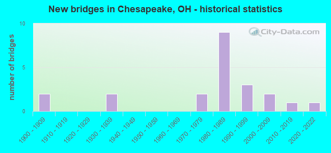
- New bridges - historical statistics
- 21900-1909
- 21930-1939
- 21970-1979
- 91980-1989
- 31990-1999
- 22000-2009
- 12010-2019
- 12020-2022


- Bridge Condition - Deck
- 6.7%Excellent
- 26.7%Good
- 33.3%Satisfactory
- 26.7%Fair
- 6.7%Serious

- Bridge Condition - Superstructure
- 6.7%Excellent
- 6.7%Very good
- 46.7%Good
- 6.7%Satisfactory
- 26.7%Fair
- 6.7%Poor

- Bridge Condition - Substructure
- 6.7%Excellent
- 6.7%Very good
- 46.7%Good
- 6.7%Satisfactory
- 26.7%Fair
- 6.7%Poor

- Bridge Condition - Channel
- 6.7%Excellent
- 13.3%Very good
- 40.0%Good
- 20.0%Satisfactory
- 20.0%Fair
Find on map >> Show street view
Structure Number: 4400038, Location: .11 MI N OF SR 527 (Lat: 38.428300, Lng: -82.450331), Route carried "on" structure: State highway 7, Year Built: 1933, Year Reconstructed: 1990, Status: Open, Structure Length: 10.61m (34.81ft), Average Daily Traffic: 11,346 (year 2015), Truck Traffic: 5%, Average Future Daily Traffic: 15,748 (year 2035), Design Load: HS 20, Features Intersected: SYMMES CREEK
Minimum Vertical Clearance: 4.70m (15.42ft), Kilometerpoint: 3.862, Lanes on structure: 2, Owner: State Highway Agency, Approaching Roadway Width: 10.7m (35.1ft), Material/Design: Steel, Design/Construction: Truss - Thru, Number Of Spans In Main Unit: 1, Number Of Approach Spans: 3, Length of Maximum Span: 49.4m (162.1ft), Curb or Sidewalk Widths: Left: 2.3m (7.5ft), Right: 2.3m (7.5ft), Curb-To-Curb Width: 10.4m (34.1ft), Out-to-Out Width: 11.0m (36.1ft)
Condition: Deck: Satisfactory, Superstructure: Fair, Substructure: Fair, Channel: Good, Operating Rating: 42.1 metric tons, Method Used To Determine Operating Rating: Allowable Stress (AS) rating reported by rating factor (RF) method using MS18 loading, Inventory Rating: 32.4 metric tons, Method Used To Determine Inventory Rating: Allowable Stress (AS) rating reported by rating factor (RF) method using MS18 loading, Structural Evaluation: Somewhat better than minimum adequacy, Deck Geometry: Meets minimum limits, Waterway Adequacy: Equal to present desirable criteria, Approach Roadway Alignment: Equal to present minimum criteria, Designated Inspection Frequency: Every 12 months, Critical Feature Inspection Frequency: Every 24 months, Inspection Date: September 2021, Critical Feature Inspection Date: October 2020, Deck Structure Type: Concrete Cast-file-Place, Wearing Surface/Protective System: Wearing Surface: Epoxy Overlay
Find on map >> Show street view
Structure Number: 4400046, Location: 1.84 MI N OF US 52 (Lat: 38.430111, Lng: -82.459981), Route carried "on" structure: State highway 7, Year Built: 1986, Status: Open, Structure Length: 16.61m (54.49ft), Average Daily Traffic: 6,200 (year 2015), Truck Traffic: 5%, Average Future Daily Traffic: 8,606 (year 2035), Design Load: HS 20, Features Intersected: SYMMES CRK & CR 31
Minimum Vertical Clearance: 30+ m (98+ ft), Kilometerpoint: 2.961, Lanes on structure: 1, Lanes under structure: 2, Base Highway Network: Yes, Owner: State Highway Agency, Approaching Roadway Width: 15.2m (49.9ft), Skew: 3 degrees, Material/Design: Steel continuous, Design/Construction: Stringer/Multi-beam, Number Of Spans In Main Unit: 6, Length of Maximum Span: 30.5m (100.1ft), Curb-To-Curb Width: 9.4m (30.8ft), Out-to-Out Width: 15.7m (51.5ft)
Condition: Deck: Good, Superstructure: Good, Substructure: Good, Channel: Good, Operating Rating: 42.1 metric tons, Method Used To Determine Operating Rating: Allowable Stress (AS) rating reported by rating factor (RF) method using MS18 loading, Inventory Rating: 32.4 metric tons, Method Used To Determine Inventory Rating: Allowable Stress (AS) rating reported by rating factor (RF) method using MS18 loading, Structural Evaluation: Better than present minimum criteria, Deck Geometry: Meets minimum limits, Underclear: Superior to present desirable criteria, Waterway Adequacy: Equal to present desirable criteria, Approach Roadway Alignment: Equal to present desirable criteria, Designated Inspection Frequency: Every 24 months, Underwater Inspection Frequency: Every 60 months, Inspection Date: November 2021, Underwater Inspection Date: July 2019, Deck Structure Type: Concrete Cast-file-Place, Wearing Surface/Protective System: Wearing Surface: Epoxy Overlay, Membrane: Epoxy
Find on map >> Show street view
Structure Number: 4400054, Location: 1.84 MI N OF US 52 (Lat: 38.430181, Lng: -82.460269), Route carried "on" structure: State highway 7, Year Built: 1986, Status: Open, Structure Length: 16.61m (54.49ft), Average Daily Traffic: 6,200 (year 2015), Truck Traffic: 5%, Average Future Daily Traffic: 8,606 (year 2035), Design Load: HS 20, Features Intersected: SYMMES CREEK & CR 31
Minimum Vertical Clearance: 30+ m (98+ ft), Kilometerpoint: 2.961, Lanes on structure: 2, Lanes under structure: 2, Base Highway Network: Yes, Owner: State Highway Agency, Approaching Roadway Width: 12.2m (40.0ft), Skew: 3 degrees, Material/Design: Steel continuous, Design/Construction: Stringer/Multi-beam, Number Of Spans In Main Unit: 6, Length of Maximum Span: 30.5m (100.1ft), Curb-To-Curb Width: 11.8m (38.7ft), Out-to-Out Width: 12.7m (41.7ft)
Condition: Deck: Good, Superstructure: Good, Substructure: Good, Channel: Good, Operating Rating: 42.1 metric tons, Method Used To Determine Operating Rating: Allowable Stress (AS) rating reported by rating factor (RF) method using MS18 loading, Inventory Rating: 32.4 metric tons, Method Used To Determine Inventory Rating: Allowable Stress (AS) rating reported by rating factor (RF) method using MS18 loading, Structural Evaluation: Better than present minimum criteria, Deck Geometry: Equal to present minimum criteria, Underclear: High priority of corrective action, Waterway Adequacy: Equal to present desirable criteria, Approach Roadway Alignment: Equal to present desirable criteria, Designated Inspection Frequency: Every 24 months, Underwater Inspection Frequency: Every 60 months, Inspection Date: November 2021, Underwater Inspection Date: July 2019, Deck Structure Type: Concrete Cast-file-Place, Wearing Surface/Protective System: Wearing Surface: Epoxy Overlay, Membrane: Epoxy
Find on map >> Show street view
Structure Number: 4403607, Location: 1.20 MI E OF 378 (Lat: 38.485661, Lng: -82.461589), Route carried "on" structure: State highway 243, Year Built: 2021, Status: Open, Structure Length: 2.38m (7.81ft), Average Daily Traffic: 2,000 (year 2020), Truck Traffic: 7%, Average Future Daily Traffic: 2,100 (year 2040), Design Load: HL 93, Features Intersected: MCKINNEY CREEK
Minimum Vertical Clearance: 30+ m (98+ ft), Kilometerpoint: 20.584, Lanes on structure: 2, Owner: State Highway Agency, Approaching Roadway Width: 8.5m (27.9ft), Skew: 1 degrees, Material/Design: Concrete continuous, Design/Construction: Box Beam or Girders - Single/Spread, Number Of Spans In Main Unit: 1, Length of Maximum Span: 22.9m (75.1ft), Curb-To-Curb Width: 11.0m (36.1ft), Out-to-Out Width: 11.0m (36.1ft)
Condition: Deck: Excellent, Superstructure: Excellent, Substructure: Excellent, Channel: Excellent, Operating Rating: 65.1 metric tons, Method Used To Determine Operating Rating: Load and Resistance Factor Rating (LRFR) rating reported by rating factor(RF) method using HL-93 loadings, Inventory Rating: 36.3 metric tons, Method Used To Determine Inventory Rating: Load and Resistance Factor Rating (LRFR) rating reported by rating factor(RF) method using HL-93 loadings, Structural Evaluation: Superior to present desirable criteria, Deck Geometry: Equal to present minimum criteria, Waterway Adequacy: Superior to present desirable criteria, Approach Roadway Alignment: Equal to present desirable criteria, Designated Inspection Frequency: Every 12 months, Inspection Date: November 2021, Wearing Surface/Protective System: Wearing Surface: Monolithic Concrete
Find on map >> Show street view
Structure Number: 4404041, Location: .20 MI N OF SR 7 (Lat: 38.429019, Lng: -82.452631), Route carried "on" structure: State highway 527, Year Built: 1986, Status: Open, Structure Length: 17.31m (56.79ft), Average Daily Traffic: 6,906 (year 2015), Truck Traffic: 3%, Average Future Daily Traffic: 9,586 (year 2035), Design Load: HS 20, Features Intersected: SYMMES CREEK & CR 123A
Minimum Vertical Clearance: 30+ m (98+ ft), Kilometerpoint: 0.322, Lanes on structure: 2, Lanes under structure: 2, Base Highway Network: Yes, Owner: State Highway Agency, Approaching Roadway Width: 12.2m (40.0ft), Skew: 2 degrees, Material/Design: Steel continuous, Design/Construction: Stringer/Multi-beam, Number Of Spans In Main Unit: 5, Length of Maximum Span: 37.2m (122.0ft), Curb-To-Curb Width: 11.1m (36.4ft), Out-to-Out Width: 12.2m (40.0ft)
Condition: Deck: Satisfactory, Superstructure: Good, Substructure: Good, Channel: Very good, Operating Rating: 42.1 metric tons, Method Used To Determine Operating Rating: Allowable Stress (AS) rating reported by rating factor (RF) method using MS18 loading, Inventory Rating: 32.4 metric tons, Method Used To Determine Inventory Rating: Allowable Stress (AS) rating reported by rating factor (RF) method using MS18 loading, Structural Evaluation: Better than present minimum criteria, Deck Geometry: Somewhat better than minimum adequacy, Underclear: Meets minimum limits, Waterway Adequacy: Equal to present desirable criteria, Approach Roadway Alignment: Equal to present desirable criteria, Designated Inspection Frequency: Every 12 months, Inspection Date: June 2021, Deck Structure Type: Concrete Cast-file-Place, Wearing Surface/Protective System: Wearing Surface: Epoxy Overlay, Membrane: Epoxy
Find on map >> Show street view
Structure Number: 4404076, Location: .20 MI N OF SR 7 (Lat: 38.429019, Lng: -82.452761), Route carried "on" structure: State highway 527, Year Built: 1986, Status: Open, Structure Length: 17.31m (56.79ft), Average Daily Traffic: 6,906 (year 2015), Truck Traffic: 3%, Average Future Daily Traffic: 9,586 (year 2035), Design Load: HS 20, Features Intersected: SYMMES CREEK & CR 123A
Minimum Vertical Clearance: 30+ m (98+ ft), Kilometerpoint: 0.322, Lanes on structure: 2, Lanes under structure: 2, Base Highway Network: Yes, Owner: State Highway Agency, Approaching Roadway Width: 12.2m (40.0ft), Skew: 2 degrees, Material/Design: Steel continuous, Design/Construction: Stringer/Multi-beam, Number Of Spans In Main Unit: 5, Length of Maximum Span: 37.2m (122.0ft), Curb-To-Curb Width: 11.1m (36.4ft), Out-to-Out Width: 11.7m (38.4ft)
Condition: Deck: Satisfactory, Superstructure: Good, Substructure: Good, Channel: Very good, Operating Rating: 42.1 metric tons, Method Used To Determine Operating Rating: Allowable Stress (AS) rating reported by rating factor (RF) method using MS18 loading, Inventory Rating: 32.4 metric tons, Method Used To Determine Inventory Rating: Allowable Stress (AS) rating reported by rating factor (RF) method using MS18 loading, Structural Evaluation: Better than present minimum criteria, Deck Geometry: Somewhat better than minimum adequacy, Underclear: Better than present minimum criteria, Waterway Adequacy: Equal to present desirable criteria, Approach Roadway Alignment: Equal to present desirable criteria, Designated Inspection Frequency: Every 12 months, Inspection Date: June 2021, Deck Structure Type: Concrete Cast-file-Place, Wearing Surface/Protective System: Wearing Surface: Epoxy Overlay, Membrane: Epoxy
Find on map >> Show street view
Structure Number: 4404084, Location: 0.18MI S.OF JCT. SR7 (Lat: 38.426281, Lng: -82.451989), Route carried "on" structure: State highway 527, Year Built: 1994, Status: Open, Structure Length: 64.16m (210.50ft), Average Daily Traffic: 13,800 (year 2013), Truck Traffic: 4%, Average Future Daily Traffic: 17,250 (year 2040), Design Load: HS 25 or greater, Features Intersected: US60, OHIO RIVER, CSX RR
Minimum Vertical Clearance: 5.18m (16.99ft), Kilometerpoint: 0.000, Lanes on structure: 4, Lanes under structure: 3, Base Highway Network: Yes, Owner: State Highway Agency, Approaching Roadway Width: 6.7m (22.0ft), Skew: 31 degrees, Navigation Control: Yes ( Vertical Clearance: 16.8m (55.1ft), Horizontal Clearance: 213.4m (700.1ft)), Material/Design: Steel, Design/Construction: Truss - Thru, Number Of Spans In Main Unit: 1, Number Of Approach Spans: 5, Length of Maximum Span: 219.5m (720.1ft), Curb or Sidewalk Widths: Left: 0.0m, Right: 1.7m (5.6ft), Curb-To-Curb Width: 18.4m (60.4ft), Out-to-Out Width: 21.9m (71.9ft)
Condition: Deck: Satisfactory, Superstructure: Good, Substructure: Satisfactory, Channel: Good, Operating Rating: 42.1 metric tons, Method Used To Determine Operating Rating: Load Factor (LF) rating reported by rating factor (RF) method using MS18 loading, Inventory Rating: 32.4 metric tons, Method Used To Determine Inventory Rating: Load Factor (LF) rating reported by rating factor (RF) method using MS18 loading, Structural Evaluation: Equal to present minimum criteria, Deck Geometry: Somewhat better than minimum adequacy, Underclear: Equal to present minimum criteria, Waterway Adequacy: Superior to present desirable criteria, Approach Roadway Alignment: Better than present minimum criteria, Designated Inspection Frequency: Every 24 months, Critical Feature Inspection Frequency: Every 24 months, Underwater Inspection Frequency: Every 60 months, Other Special Inspection Frequency: Every 12 months, Inspection Date: November 2019, Critical Feature Inspection Date: November 2019, Underwater Inspection Date: October 2018, Other Special Inspection Date: October 2020, Deck Structure Type: Concrete Cast-file-Place, Wearing Surface/Protective System: Wearing Surface: Integral Concrete, Deck Protection: Epoxy Coated Reinforcing
Find on map >> Show street view
Structure Number: 4404092, Location: 0.65 mi. North of OH/WVA (Lat: 38.433939, Lng: -82.457300), Route carried "on" structure: State highway 7, Year Built: 1973, Status: Open, Structure Length: 6.92m (22.70ft), Average Daily Traffic: 12,400 (year 2015), Truck Traffic: 5%, Average Future Daily Traffic: 17,211 (year 2035), Design Load: HS 20, Features Intersected: SR 7-0214
Minimum Vertical Clearance: 30+ m (98+ ft), Kilometerpoint: 3.444, Lanes on structure: 2, Lanes under structure: 2, Base Highway Network: Yes, Owner: State Highway Agency, Approaching Roadway Width: 6.1m (20.0ft), Skew: 11 degrees, Material/Design: Steel continuous, Design/Construction: Stringer/Multi-beam, Number Of Spans In Main Unit: 2, Length of Maximum Span: 36.3m (119.1ft), Curb-To-Curb Width: 17.1m (56.1ft), Out-to-Out Width: 17.1m (56.1ft)
Condition: Deck: Good, Superstructure: Good, Substructure: Good, Operating Rating: 42.1 metric tons, Method Used To Determine Operating Rating: Allowable Stress (AS) rating reported by rating factor (RF) method using MS18 loading, Inventory Rating: 32.4 metric tons, Method Used To Determine Inventory Rating: Allowable Stress (AS) rating reported by rating factor (RF) method using MS18 loading, Structural Evaluation: Better than present minimum criteria, Deck Geometry: Superior to present desirable criteria, Underclear: Meets minimum limits, Approach Roadway Alignment: Equal to present desirable criteria, Designated Inspection Frequency: Every 24 months, Inspection Date: November 2021, Deck Structure Type: Concrete Cast-file-Place, Wearing Surface/Protective System: Wearing Surface: Epoxy Overlay, Deck Protection: Epoxy Coated Reinforcing
Find on map >> Show street view
Structure Number: 4434749, Location: 270 FT W OF CTY ROAD 35 (Lat: 38.480289, Lng: -82.468031), Route carried "on" structure: County highway C0017, Year Built: 2002, Status: Open, Structure Length: 0.79m (2.59ft), Average Daily Traffic: 1,209 (year 2015), Truck Traffic: 7%, Average Future Daily Traffic: 1,678 (year 2038), Design Load: HS 20+Mod, Features Intersected: RANKINS CREEK, Facility Carried by Structure: RANKINS CREEK RD
Minimum Vertical Clearance: 30+ m (98+ ft), Kilometerpoint: 8.127, Lanes on structure: 2, Owner: County Highway Agency, Approaching Roadway Width: 7.6m (24.9ft), Skew: 3 degrees, Material/Design: Concrete, Design/Construction: Frame, Number Of Spans In Main Unit: 1, Length of Maximum Span: 7.3m (24.0ft), Curb-To-Curb Width: 9.8m (32.2ft), Out-to-Out Width: 22.9m (75.1ft)
Condition: Deck: Good, Superstructure: Good, Substructure: Very good, Channel: Good, Operating Rating: 68.0 metric tons, Method Used To Determine Operating Rating: Load Factor (LF) rating reported by rating factor (RF) method using MS18 loading, Inventory Rating: 42.1 metric tons, Method Used To Determine Inventory Rating: Load Factor (LF) rating reported by rating factor (RF) method using MS18 loading, Structural Evaluation: Better than present minimum criteria, Deck Geometry: Somewhat better than minimum adequacy, Waterway Adequacy: Equal to present minimum criteria, Approach Roadway Alignment: Better than present minimum criteria, Designated Inspection Frequency: Every 24 months, Inspection Date: January 2022, Deck Structure Type: Concrete Cast-file-Place, Wearing Surface/Protective System: Wearing Surface: Bituminous, Membrane: Preformed Fabric, Deck Protection: Epoxy Coated Reinforcing
Find on map >> Show street view
Structure Number: 4434773, Location: 5.22 MILES EAST OF SR 243 (Lat: 38.482369, Lng: -82.467900), Route carried "on" structure: County highway C0017, Year Built: 2002, Status: Open, Structure Length: 0.79m (2.59ft), Average Daily Traffic: 1,209 (year 2015), Truck Traffic: 7%, Average Future Daily Traffic: 1,678 (year 2035), Design Load: HS 20+Mod, Features Intersected: RANKINS CREEK, Facility Carried by Structure: COUNTY ROAD 17
Minimum Vertical Clearance: 30+ m (98+ ft), Kilometerpoint: 8.401, Lanes on structure: 2, Owner: County Highway Agency, Approaching Roadway Width: 5.5m (18.0ft), Material/Design: Concrete, Design/Construction: Culvert, Number Of Spans In Main Unit: 1, Length of Maximum Span: 7.3m (24.0ft)
Condition: Channel: Fair, Culverts: Good, Operating Rating: 58.3 metric tons, Method Used To Determine Operating Rating: Load Factor (LF) rating reported by rating factor (RF) method using MS18 loading, Inventory Rating: 35.6 metric tons, Method Used To Determine Inventory Rating: Load Factor (LF) rating reported by rating factor (RF) method using MS18 loading, Structural Evaluation: Better than present minimum criteria, Waterway Adequacy: Equal to present desirable criteria, Approach Roadway Alignment: Better than present minimum criteria, Designated Inspection Frequency: Every 24 months, Inspection Date: April 2020, Wearing Surface/Protective System: Membrane: Built-up, Deck Protection: Epoxy Coated Reinforcing
Find on map >> Show street view
Structure Number: 4434803, Location: 58 FT S OF ST RT 243 (Lat: 38.485950, Lng: -82.468689), Route carried "on" structure: County highway C0017, Year Built: 1900, Year Reconstructed: 1999, Status: Posted for load, Structure Length: 3.20m (10.50ft), Average Daily Traffic: 1,209 (year 2015), Truck Traffic: 7%, Average Future Daily Traffic: 1,678 (year 2035), Features Intersected: SYMMES CREEK, Facility Carried by Structure: RANKINS CREEK RD
Minimum Vertical Clearance: 30+ m (98+ ft), Kilometerpoint: 8.803, Lanes on structure: 2, Owner: County Highway Agency, Approaching Roadway Width: 6.7m (22.0ft), Material/Design: Steel, Design/Construction: Truss - Thru, Number Of Spans In Main Unit: 1, Length of Maximum Span: 31.4m (103.0ft), Curb-To-Curb Width: 6.1m (20.0ft), Out-to-Out Width: 6.4m (21.0ft)
Condition: Deck: Fair, Superstructure: Fair, Substructure: Fair, Channel: Satisfactory, Operating Rating: 22.7 metric tons, Method Used To Determine Operating Rating: Load Factor (LF) rating reported by rating factor (RF) method using MS18 loading, Inventory Rating: 13.0 metric tons, Method Used To Determine Inventory Rating: Load Factor (LF) rating reported by rating factor (RF) method using MS18 loading, Structural Evaluation: Meets minimum limits, Deck Geometry: High priority of replacement, Waterway Adequacy: Equal to present desirable criteria, Approach Roadway Alignment: Equal to present minimum criteria, Bridge Posting: Required (Relationship of Operating Rating to Maximum Legal Load: 30.0 - 39.9% below), Designated Inspection Frequency: Every 12 months, Critical Feature Inspection Frequency: Every 24 months, Inspection Date: March 2021, Critical Feature Inspection Date: March 2021, Deck Structure Type: Corrugated Steel, Wearing Surface/Protective System: Wearing Surface: Bituminous
Find on map >> Show street view
Structure Number: 4437055, Location: 1.53 MILES NORTH OF CHES. (Lat: 38.444419, Lng: -82.468469), Route carried "on" structure: County highway C0031, Year Built: 2010, Status: Open, Structure Length: 1.10m (3.61ft), Average Daily Traffic: 1,336 (year 2015), Truck Traffic: 7%, Average Future Daily Traffic: 1,854 (year 2038), Design Load: HS 20, Features Intersected: BIG BRANCH CREEK, Facility Carried by Structure: BIG BRANCH ROAD
Minimum Vertical Clearance: 30+ m (98+ ft), Kilometerpoint: 2.462, Lanes on structure: 2, Owner: County Highway Agency, Approaching Roadway Width: 6.4m (21.0ft), Skew: 2 degrees, Material/Design: Steel, Design/Construction: Stringer/Multi-beam, Number Of Spans In Main Unit: 1, Length of Maximum Span: 10.7m (35.1ft), Curb-To-Curb Width: 7.3m (24.0ft), Out-to-Out Width: 7.3m (24.0ft)
Condition: Deck: Satisfactory, Superstructure: Very good, Substructure: Good, Channel: Satisfactory, Operating Rating: 64.8 metric tons, Method Used To Determine Operating Rating: Allowable Stress (AS) rating reported by rating factor (RF) method using MS18 loading, Inventory Rating: 45.4 metric tons, Method Used To Determine Inventory Rating: Allowable Stress (AS) rating reported by rating factor (RF) method using MS18 loading, Structural Evaluation: Better than present minimum criteria, Deck Geometry: Meets minimum limits, Waterway Adequacy: Somewhat better than minimum adequacy, Approach Roadway Alignment: Equal to present minimum criteria, Designated Inspection Frequency: Every 12 months, Inspection Date: December 2021, Deck Structure Type: Corrugated Steel, Wearing Surface/Protective System: Wearing Surface: Bituminous
Find on map >> Show street view
Structure Number: 443716, Location: 458 FT S OF CTY RD 17 (Lat: 38.479669, Lng: -82.488739), Route carried "on" structure: County highway C0031, Year Built: 1994, Status: Open, Structure Length: 1.16m (3.81ft), Average Daily Traffic: 1,336 (year 2015), Truck Traffic: 7%, Average Future Daily Traffic: 1,854 (year 2035), Design Load: HS 20, Features Intersected: RANKINS CREEK, Facility Carried by Structure: BIG BRANCH ROAD
Minimum Vertical Clearance: 30+ m (98+ ft), Kilometerpoint: 7.306, Lanes on structure: 2, Owner: County Highway Agency, Approaching Roadway Width: 6.1m (20.0ft), Material/Design: Steel, Design/Construction: Stringer/Multi-beam, Number Of Spans In Main Unit: 1, Length of Maximum Span: 11.0m (36.1ft), Curb-To-Curb Width: 6.7m (22.0ft), Out-to-Out Width: 6.7m (22.0ft)
Condition: Deck: Fair, Superstructure: Fair, Substructure: Poor, Channel: Fair, Operating Rating: 42.1 metric tons, Method Used To Determine Operating Rating: Allowable Stress (AS) rating reported by rating factor (RF) method using MS18 loading, Inventory Rating: 32.4 metric tons, Method Used To Determine Inventory Rating: Allowable Stress (AS) rating reported by rating factor (RF) method using MS18 loading, Structural Evaluation: Meets minimum limits, Deck Geometry: High priority of corrective action, Waterway Adequacy: Equal to present minimum criteria, Approach Roadway Alignment: Somewhat better than minimum adequacy, Designated Inspection Frequency: Every 12 months, Inspection Date: December 2021, Deck Structure Type: Wood or Timber, Wearing Surface/Protective System: Wearing Surface: Bituminous
Find on map >> Show street view
Structure Number: 4445031, Location: 125 FT N OF CTY RD 32 (Lat: 38.442161, Lng: -82.435369), Route carried "on" structure: County highway C0104, Year Built: 1987, Status: Open, Structure Length: 5.46m (17.91ft), Average Daily Traffic: 334 (year 2015), Truck Traffic: 5%, Average Future Daily Traffic: 464 (year 2035), Design Load: H 20, Features Intersected: SYMMES CREEK, Facility Carried by Structure: BOOTHE-FATON RD
Minimum Vertical Clearance: 30+ m (98+ ft), Kilometerpoint: 0.016, Lanes on structure: 2, Owner: County Highway Agency, Approaching Roadway Width: 9.8m (32.2ft), Material/Design: Prestressed concrete continuous, Design/Construction: Box Beam or Girders - Multiple, Number Of Spans In Main Unit: 3, Length of Maximum Span: 20.1m (65.9ft), Curb-To-Curb Width: 8.5m (27.9ft), Out-to-Out Width: 8.5m (27.9ft)
Condition: Deck: Fair, Superstructure: Fair, Substructure: Good, Channel: Satisfactory, Operating Rating: 71.3 metric tons, Method Used To Determine Operating Rating: Load Factor (LF) rating reported by rating factor (RF) method using MS18 loading, Inventory Rating: 42.1 metric tons, Method Used To Determine Inventory Rating: Load Factor (LF) rating reported by rating factor (RF) method using MS18 loading, Structural Evaluation: Somewhat better than minimum adequacy, Deck Geometry: Equal to present minimum criteria, Waterway Adequacy: Better than present minimum criteria, Approach Roadway Alignment: Better than present minimum criteria, Designated Inspection Frequency: Every 12 months, Inspection Date: December 2021, Deck Structure Type: Concrete Cast-file-Place, Wearing Surface/Protective System: Wearing Surface: Bituminous
Find on map >> Show street view
Structure Number: 4445082, Location: 114 FT N OF CTY RD 32 (Lat: 38.460689, Lng: -82.434350), Route carried "on" structure: County highway C0104, Year Built: 1939, Status: Posted for load, Structure Length: 2.90m (9.51ft), Average Daily Traffic: 334 (year 2015), Truck Traffic: 5%, Average Future Daily Traffic: 464 (year 2035), Features Intersected: SYMMES CREEK, Facility Carried by Structure: BOOTHE EATON RD
Minimum Vertical Clearance: 30+ m (98+ ft), Kilometerpoint: 3.862, Lanes on structure: 2, Owner: County Highway Agency, Approaching Roadway Width: 7.0m (23.0ft), Material/Design: Steel, Design/Construction: Truss - Thru, Number Of Spans In Main Unit: 1, Length of Maximum Span: 27.7m (90.9ft), Curb-To-Curb Width: 5.8m (19.0ft), Out-to-Out Width: 5.8m (19.0ft)
Condition: Deck: Serious, Superstructure: Poor, Substructure: Fair, Channel: Fair, Operating Rating: 29.2 metric tons, Method Used To Determine Operating Rating: Load Factor (LF) rating reported by rating factor (RF) method using MS18 loading, Inventory Rating: 16.2 metric tons, Method Used To Determine Inventory Rating: Load Factor (LF) rating reported by rating factor (RF) method using MS18 loading, Structural Evaluation: Meets minimum limits, Deck Geometry: High priority of corrective action, Waterway Adequacy: Equal to present desirable criteria, Approach Roadway Alignment: Better than present minimum criteria, Bridge Posting: Required (Relationship of Operating Rating to Maximum Legal Load: 20.0 - 29.9% below), Designated Inspection Frequency: Every 12 months, Critical Feature Inspection Frequency: Every 24 months, Inspection Date: March 2021, Critical Feature Inspection Date: March 2021, Deck Structure Type: Wood or Timber, Wearing Surface/Protective System: Wearing Surface: Bituminous
Find on map >> Show street view
Structure Number: 4449991, Location: 0.03 MILES EAST OF CR 31 (Lat: 38.439669, Lng: -82.465169), Route carried "on" structure: County highway T0158, Year Built: 1900, Year Reconstructed: 1996, Status: Open, Structure Length: 0.88m (2.89ft), Average Daily Traffic: 198 (year 2015), Truck Traffic: 5%, Average Future Daily Traffic: 275 (year 2035), Design Load: HS 20, Features Intersected: BIG BRANCH CREEK, Facility Carried by Structure: HENSON HOLLOW RD
Minimum Vertical Clearance: 30+ m (98+ ft), Kilometerpoint: 0.048, Lanes on structure: 1, Owner: County Highway Agency, Approaching Roadway Width: 5.5m (18.0ft), Material/Design: Steel, Design/Construction: Stringer/Multi-beam, Number Of Spans In Main Unit: 1, Length of Maximum Span: 7.3m (24.0ft), Curb-To-Curb Width: 6.1m (20.0ft), Out-to-Out Width: 6.1m (20.0ft)
Condition: Deck: Fair, Superstructure: Satisfactory, Substructure: Fair, Channel: Good, Operating Rating: 97.2 metric tons, Method Used To Determine Operating Rating: Allowable Stress (AS) rating reported by rating factor (RF) method using MS18 loading, Inventory Rating: 68.0 metric tons, Method Used To Determine Inventory Rating: Allowable Stress (AS) rating reported by rating factor (RF) method using MS18 loading, Structural Evaluation: Somewhat better than minimum adequacy, Deck Geometry: Meets minimum limits, Waterway Adequacy: Equal to present desirable criteria, Approach Roadway Alignment: Somewhat better than minimum adequacy, Length Of Structure Improvement: 7.01m (23.00ft), Designated Inspection Frequency: Every 12 months, Inspection Date: December 2021, Bridge Improvement Cost: $14,000, Roadway Improvement Cost: $1,000, Total Project Cost: $34,000, Deck Structure Type: Wood or Timber, Wearing Surface/Protective System: Wearing Surface: Bituminous
Find on map >> Show street view
Structure Number: 4400046, Location: 1.84 MI N OF US 52 (Lat: 38.430111, Lng: -82.459981), Route carried "under" structure: County highway 31, Year Built: 1986, Structure Length: 0. m, Average Daily Traffic: 4,060 (year 2015), Truck Traffic: 5%, Features Intersected: STATE ROUTE 7, Facility Carried by Structure: SR 7
Minimum Vertical Clearance: 5.18m (16.99ft), Kilometerpoint: 0.435, Lanes on structure: 1, Lanes under structure: 2, Material/Design: Steel continuous, Design/Construction: Stringer/Multi-beam, Length of Maximum Span: 30.5m (100.1ft)
Find on map >> Show street view
Structure Number: 4400054, Location: 1.84 MI N OF US 52 (Lat: 38.430181, Lng: -82.460269), Route carried "under" structure: County highway 31, Year Built: 1986, Structure Length: 0. m, Average Daily Traffic: 4,060 (year 2015), Truck Traffic: 5%, Features Intersected: STATE ROUTE 7, Facility Carried by Structure: SR 7
Minimum Vertical Clearance: 4.18m (13.71ft), Kilometerpoint: 0.451, Lanes on structure: 2, Lanes under structure: 2, Material/Design: Steel continuous, Design/Construction: Stringer/Multi-beam, Length of Maximum Span: 30.5m (100.1ft)
Find on map >> Show street view
Structure Number: 4404041, Location: .20 MI N OF SR 7 (Lat: 38.429019, Lng: -82.452631), Route carried "under" structure: County highway 123, Year Built: 1986, Structure Length: 0. m, Average Daily Traffic: 829 (year 2015), Truck Traffic: 5%, Features Intersected: STATE ROUTE 527, Facility Carried by Structure: SR 527
Minimum Vertical Clearance: 4.44m (14.57ft), Kilometerpoint: 0.402, Lanes on structure: 2, Lanes under structure: 2, Material/Design: Steel continuous, Design/Construction: Stringer/Multi-beam, Length of Maximum Span: 37.2m (122.0ft)
Find on map >> Show street view
Structure Number: 4404076, Location: .20 MI N OF SR 7 (Lat: 38.429019, Lng: -82.452761), Route carried "under" structure: County highway 123, Year Built: 1986, Structure Length: 0. m, Average Daily Traffic: 829 (year 2015), Truck Traffic: 5%, Features Intersected: STATE ROUTE 527, Facility Carried by Structure: SR 527
Minimum Vertical Clearance: 4.80m (15.75ft), Kilometerpoint: 0.402, Lanes on structure: 2, Lanes under structure: 2, Material/Design: Steel continuous, Design/Construction: Stringer/Multi-beam, Length of Maximum Span: 37.2m (122.0ft)
Find on map >> Show street view
Structure Number: 4404084, Location: 0.18MI S.OF JCT. SR7 (Lat: 38.426281, Lng: -82.451989), Route carried "under" structure: US 60, Year Built: 1994, Structure Length: 0. m, Average Daily Traffic: 8,042 (year 2017), Truck Traffic: 5%, Features Intersected: SR-527, Facility Carried by Structure: SR 527
Minimum Vertical Clearance: 4.88m (16.01ft), Kilometerpoint: 5.552, Lanes on structure: 4, Lanes under structure: 3, Material/Design: Steel, Design/Construction: Truss - Thru, Length of Maximum Span: 219.5m (720.1ft)
Find on map >> Show street view
Structure Number: 4404092, Location: 0.65 mi. North of OH/WVA (Lat: 38.433939, Lng: -82.457300), Route carried "under" structure: State highway 7, Year Built: 1973, Structure Length: 0. m, Average Daily Traffic: 14,155 (year 2015), Truck Traffic: 5%, Features Intersected: SR 7-0215 OVER SR 7-0214
Minimum Vertical Clearance: 4.72m (15.49ft), Kilometerpoint: 3.444, Lanes on structure: 2, Lanes under structure: 2, Material/Design: Steel continuous, Design/Construction: Stringer/Multi-beam, Length of Maximum Span: 36.3m (119.1ft)