Bridge Statistics for Chesterfield, New York (NY)
Condition, Traffic, Stress, Structural Evaluation, Project Costs
- National Bridge Inventory (NBI) Statistics
- 24Number of bridges
- 253ft / 76.7mTotal length
- $35,454,000Total costs
- 54,999Total average daily traffic
- 11,216Total average daily truck traffic
- National Bridge Inventory (NBI) Registered Bridges for Chesterfield
- No street view available for this location
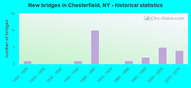
- New bridges - historical statistics
- 11920-1929
- 11950-1959
- 101960-1969
- 11980-1989
- 21990-1999
- 52000-2009
- 42010-2019

- Reconstructed bridges - Historical Statistics
- 12000-2009
- 12010-2019
- 22020-2022


- Bridge Condition - Deck
- 38.5%Excellent
- 15.4%Very good
- 30.8%Good
- 15.4%Satisfactory

- Bridge Condition - Superstructure
- 20.0%Excellent
- 46.7%Very good
- 33.3%Good

- Bridge Condition - Substructure
- 20.0%Excellent
- 33.3%Very good
- 33.3%Good
- 13.3%Satisfactory

- Bridge Condition - Channel
- 40.0%Very good
- 20.0%Good
- 10.0%Satisfactory
- 30.0%Fair

- Bridge Condition - Culverts
- 66.7%Good
- 33.3%Satisfactory
Find on map >> Show street view
Structure Number: 1005911, Location: 2.3 MI S JCT RTS I87 & 22 (Lat: 44.412781, Lng: -73.497239), Route carried "on" structure: Interstate 87, Year Built: 2014, Status: Open, Structure Length: 4.48m (14.70ft), Average Daily Traffic: 4,405 (year 2005), Truck Traffic: 29%, Average Future Daily Traffic: 4,274 (year 2035), Design Load: HL 93, Features Intersected: RTE 9
Minimum Vertical Clearance: 30+ m (98+ ft), Kilometerpoint: 82.896, Lanes on structure: 2, Lanes under structure: 2, Base Highway Network: Yes, Owner: State Highway Agency, Approaching Roadway Width: 12.2m (40.0ft), Skew: 3 degrees, Material/Design: Steel, Design/Construction: Stringer/Multi-beam, Number Of Spans In Main Unit: 1, Length of Maximum Span: 42.7m (140.1ft), Curb-To-Curb Width: 12.2m (40.0ft), Out-to-Out Width: 13.2m (43.3ft)
Condition: Deck: Excellent, Superstructure: Excellent, Substructure: Excellent, Operating Rating: 98.9 metric tons, Method Used To Determine Operating Rating: Load Factor (LF), Inventory Rating: 59.0 metric tons, Method Used To Determine Inventory Rating: Load Factor (LF), Structural Evaluation: Superior to present desirable criteria, Deck Geometry: Better than present minimum criteria, Underclear: Meets minimum limits, Approach Roadway Alignment: Equal to present desirable criteria, Length Of Structure Improvement: 4.48m (14.70ft), Designated Inspection Frequency: Every 24 months, Inspection Date: August 2020, Bridge Improvement Cost: $1,820,000, Roadway Improvement Cost: $1,066,000, Total Project Cost: $2,886,000 ( Estimate for 2021), Deck Structure Type: Concrete Cast-file-Place, Wearing Surface/Protective System: Wearing Surface: Integral Concrete, Deck Protection: Epoxy Coated Reinforcing
Find on map >> Show street view
Structure Number: 1005912, Location: 2.3 MI S JCT RTS I87 & 22 (Lat: 44.413097, Lng: -73.496983), Route carried "on" structure: Interstate 87, Year Built: 2015, Status: Open, Structure Length: 4.48m (14.70ft), Average Daily Traffic: 2,768 (year 2018), Truck Traffic: 33%, Average Future Daily Traffic: 3,296 (year 2040), Design Load: HL 93, Features Intersected: RTE 9
Minimum Vertical Clearance: 30+ m (98+ ft), Kilometerpoint: 82.896, Lanes on structure: 2, Lanes under structure: 2, Base Highway Network: Yes, Owner: State Highway Agency, Approaching Roadway Width: 12.2m (40.0ft), Skew: 3 degrees, Material/Design: Steel, Design/Construction: Stringer/Multi-beam, Number Of Spans In Main Unit: 1, Length of Maximum Span: 42.7m (140.1ft), Curb-To-Curb Width: 12.2m (40.0ft), Out-to-Out Width: 13.2m (43.3ft)
Condition: Deck: Excellent, Superstructure: Excellent, Substructure: Excellent, Inventory Rating: 73.5 metric tons, Method Used To Determine Inventory Rating: Load Factor (LF), Structural Evaluation: Superior to present desirable criteria, Deck Geometry: Better than present minimum criteria, Underclear: Meets minimum limits, Approach Roadway Alignment: Equal to present desirable criteria, Length Of Structure Improvement: 4.48m (14.70ft), Designated Inspection Frequency: Every 24 months, Inspection Date: August 2020, Bridge Improvement Cost: $2,281,000, Roadway Improvement Cost: $1,336,000, Total Project Cost: $3,617,000 ( Estimate for 2021), Deck Structure Type: Concrete Cast-file-Place, Wearing Surface/Protective System: Wearing Surface: Integral Concrete, Deck Protection: Epoxy Coated Reinforcing
Find on map >> Show street view
Structure Number: 100592, Location: 2.5 MI N JCT RTS 22 & I87 (Lat: 44.478444, Lng: -73.486875), Route carried "on" structure: US 9, Year Built: 1929, Status: Open, Structure Length: 1.01m (3.31ft), Average Daily Traffic: 1,460 (year 2015), Truck Traffic: 8%, Average Future Daily Traffic: 1,523 (year 2040), Features Intersected: MUD BROOK
Minimum Vertical Clearance: 30+ m (98+ ft), Kilometerpoint: 89.702, Lanes on structure: 2, Base Highway Network: Yes, Owner: State Highway Agency, Approaching Roadway Width: 7.9m (25.9ft), Material/Design: Concrete, Design/Construction: Tee Beam, Number Of Spans In Main Unit: 1, Length of Maximum Span: 9.1m (29.9ft), Curb-To-Curb Width: 8.0m (26.2ft), Out-to-Out Width: 8.8m (28.9ft)
Condition: Deck: Good, Superstructure: Good, Substructure: Satisfactory, Channel: Satisfactory, Operating Rating: 36.0 metric tons, Method Used To Determine Operating Rating: Load and Resistance Factor Rating (LRFR) rating reported by rating factor(RF) method using HL-93 loadings, Inventory Rating: 27.9 metric tons, Method Used To Determine Inventory Rating: Load and Resistance Factor Rating (LRFR) rating reported by rating factor(RF) method using HL-93 loadings, Structural Evaluation: Equal to present minimum criteria, Deck Geometry: Meets minimum limits, Waterway Adequacy: Meets minimum limits, Approach Roadway Alignment: Equal to present desirable criteria, Length Of Structure Improvement: 1.00m (3.28ft), Designated Inspection Frequency: Every 24 months, Underwater Inspection Frequency: Every 60 months, Inspection Date: August 2020, Underwater Inspection Date: September 2017, Bridge Improvement Cost: $348,000, Roadway Improvement Cost: $204,000, Total Project Cost: $552,000 ( Estimate for 2021), Deck Structure Type: Concrete Cast-file-Place, Wearing Surface/Protective System: Wearing Surface: Bituminous
Find on map >> Show street view
Structure Number: 100593, Location: 0.1 MI S JCT RTS 9 & 22 (Lat: 44.506839, Lng: -73.479278), Route carried "on" structure: US 9, Year Built: 1958, Year Reconstructed: 2007, Status: Open, Structure Length: 7.07m (23.20ft), Average Daily Traffic: 1,578 (year 2018), Truck Traffic: 16%, Average Future Daily Traffic: 1,646 (year 2040), Design Load: HL 93, Features Intersected: AUSABLE RIVER
Minimum Vertical Clearance: 30+ m (98+ ft), Kilometerpoint: 0.000, Lanes on structure: 2, Base Highway Network: Yes, Owner: State Highway Agency, Approaching Roadway Width: 10.7m (35.1ft), Skew: 3 degrees, Material/Design: Steel, Design/Construction: Stringer/Multi-beam, Number Of Spans In Main Unit: 3, Length of Maximum Span: 23.1m (75.8ft), Curb or Sidewalk Widths: Left: 1.7m (5.6ft), Right: 0.0m, Curb-To-Curb Width: 10.8m (35.4ft), Out-to-Out Width: 13.6m (44.6ft)
Condition: Deck: Very good, Superstructure: Very good, Substructure: Good, Operating Rating: 72.6 metric tons, Method Used To Determine Operating Rating: Load Factor (LF), Inventory Rating: 43.5 metric tons, Method Used To Determine Inventory Rating: Load Factor (LF), Structural Evaluation: Better than present minimum criteria, Deck Geometry: Equal to present minimum criteria, Waterway Adequacy: Superior to present desirable criteria, Approach Roadway Alignment: Equal to present desirable criteria, Length Of Structure Improvement: 7.07m (23.20ft), Designated Inspection Frequency: Every 24 months, Inspection Date: October 2021, Bridge Improvement Cost: $2,547,000, Roadway Improvement Cost: $1,492,000, Total Project Cost: $4,039,000 ( Estimate for 2021), Deck Structure Type: Concrete Cast-file-Place, Wearing Surface/Protective System: Wearing Surface: Integral Concrete, Deck Protection: Epoxy Coated Reinforcing
Find on map >> Show street view
Structure Number: 1033651, Location: I87 AT CLINTON CO LINE (Lat: 44.491092, Lng: -73.494703), Route carried "on" structure: Interstate 87, Year Built: 1995, Status: Open, Structure Length: 11.70m (38.39ft), Average Daily Traffic: 5,051 (year 2011), Truck Traffic: 34%, Design Load: HS 25 or greater, Features Intersected: AUSABLE RIVER
Minimum Vertical Clearance: 30+ m (98+ ft), Kilometerpoint: 92.678, Lanes on structure: 2, Base Highway Network: Yes, Owner: State Highway Agency, Approaching Roadway Width: 12.2m (40.0ft), Material/Design: Steel continuous, Design/Construction: Stringer/Multi-beam, Number Of Spans In Main Unit: 3, Length of Maximum Span: 54.8m (179.8ft), Curb-To-Curb Width: 12.2m (40.0ft), Out-to-Out Width: 12.8m (42.0ft)
Condition: Deck: Good, Superstructure: Very good, Substructure: Very good, Channel: Very good, Operating Rating: 89.8 metric tons, Method Used To Determine Operating Rating: Load Factor (LF), Inventory Rating: 52.6 metric tons, Method Used To Determine Inventory Rating: Load Factor (LF), Structural Evaluation: Equal to present desirable criteria, Deck Geometry: Better than present minimum criteria, Waterway Adequacy: Superior to present desirable criteria, Approach Roadway Alignment: Equal to present desirable criteria, Length Of Structure Improvement: 11.70m (38.39ft), Designated Inspection Frequency: Every 24 months, Inspection Date: July 2021, Bridge Improvement Cost: $3,161,000, Roadway Improvement Cost: $1,851,000, Total Project Cost: $5,013,000 ( Estimate for 2021), Deck Structure Type: Concrete Cast-file-Place, Wearing Surface/Protective System: Wearing Surface: Integral Concrete, Deck Protection: Epoxy Coated Reinforcing
Find on map >> Show street view
Structure Number: 1033652, Location: I87 AT CLINTON CO LINE (Lat: 44.490947, Lng: -73.494033), Route carried "on" structure: Interstate 87, Year Built: 1994, Status: Open, Structure Length: 11.70m (38.39ft), Average Daily Traffic: 2,003 (year 2017), Truck Traffic: 26%, Average Future Daily Traffic: 2,385 (year 2040), Design Load: HS 25 or greater, Features Intersected: AUSABLE RIVER
Minimum Vertical Clearance: 30+ m (98+ ft), Kilometerpoint: 0.000, Lanes on structure: 2, Base Highway Network: Yes, Owner: State Highway Agency, Approaching Roadway Width: 12.2m (40.0ft), Material/Design: Steel continuous, Design/Construction: Stringer/Multi-beam, Number Of Spans In Main Unit: 3, Length of Maximum Span: 54.8m (179.8ft), Curb-To-Curb Width: 12.2m (40.0ft), Out-to-Out Width: 12.8m (42.0ft)
Condition: Deck: Satisfactory, Superstructure: Very good, Substructure: Very good, Channel: Very good, Operating Rating: 89.8 metric tons, Method Used To Determine Operating Rating: Load Factor (LF), Inventory Rating: 52.6 metric tons, Method Used To Determine Inventory Rating: Load Factor (LF), Structural Evaluation: Equal to present desirable criteria, Deck Geometry: Better than present minimum criteria, Waterway Adequacy: Superior to present desirable criteria, Approach Roadway Alignment: Equal to present desirable criteria, Length Of Structure Improvement: 11.70m (38.39ft), Designated Inspection Frequency: Every 24 months, Inspection Date: July 2021, Bridge Improvement Cost: $3,161,000, Roadway Improvement Cost: $1,851,000, Total Project Cost: $5,013,000 ( Estimate for 2021), Deck Structure Type: Concrete Cast-file-Place, Wearing Surface/Protective System: Wearing Surface: Integral Concrete, Deck Protection: Epoxy Coated Reinforcing
Find on map >> Show street view
Structure Number: 1033851, Location: 1.6 MI N JCT RTS I87 & 22 (Lat: 44.466722, Lng: -73.485833), Route carried "on" structure: Interstate 87, Year Built: 1965, Year Reconstructed: 2019, Status: Open, Structure Length: 3.02m (9.91ft), Average Daily Traffic: 5,722 (year 2007), Truck Traffic: 27%, Features Intersected: UNDERPASS ROAD
Minimum Vertical Clearance: 30+ m (98+ ft), Kilometerpoint: 89.026, Lanes on structure: 2, Lanes under structure: 2, Base Highway Network: Yes, Owner: State Highway Agency, Approaching Roadway Width: 11.9m (39.0ft), Material/Design: Steel, Design/Construction: Stringer/Multi-beam, Number Of Spans In Main Unit: 1, Length of Maximum Span: 28.6m (93.8ft), Curb-To-Curb Width: 11.8m (38.7ft), Out-to-Out Width: 12.7m (41.7ft)
Condition: Deck: Excellent, Superstructure: Very good, Substructure: Very good, Operating Rating: 79.8 metric tons, Method Used To Determine Operating Rating: Load Factor (LF), Inventory Rating: 47.2 metric tons, Method Used To Determine Inventory Rating: Load Factor (LF), Structural Evaluation: Equal to present desirable criteria, Deck Geometry: Equal to present minimum criteria, Underclear: Meets minimum limits, Approach Roadway Alignment: Equal to present desirable criteria, Length Of Structure Improvement: 3.01m (9.88ft), Designated Inspection Frequency: Every 24 months, Inspection Date: April 2021, Bridge Improvement Cost: $958,000, Roadway Improvement Cost: $561,000, Total Project Cost: $1,519,000 ( Estimate for 2021), Deck Structure Type: Concrete Cast-file-Place, Wearing Surface/Protective System: Wearing Surface: Monolithic Concrete
Find on map >> Show street view
Structure Number: 1033852, Location: 1.6 MI N JCT RTS I87 & 22 (Lat: 44.466728, Lng: -73.485497), Route carried "on" structure: Interstate 87, Year Built: 1965, Status: Open, Structure Length: 3.02m (9.91ft), Average Daily Traffic: 3,224 (year 2018), Truck Traffic: 29%, Average Future Daily Traffic: 3,839 (year 2040), Features Intersected: UNDERPASS ROAD
Minimum Vertical Clearance: 30+ m (98+ ft), Kilometerpoint: 89.026, Lanes on structure: 2, Lanes under structure: 2, Base Highway Network: Yes, Owner: State Highway Agency, Approaching Roadway Width: 11.9m (39.0ft), Material/Design: Steel, Design/Construction: Stringer/Multi-beam, Number Of Spans In Main Unit: 1, Length of Maximum Span: 28.6m (93.8ft), Curb-To-Curb Width: 11.9m (39.0ft), Out-to-Out Width: 12.8m (42.0ft)
Condition: Deck: Satisfactory, Superstructure: Good, Substructure: Good, Operating Rating: 79.8 metric tons, Method Used To Determine Operating Rating: Load Factor (LF), Inventory Rating: 47.2 metric tons, Method Used To Determine Inventory Rating: Load Factor (LF), Structural Evaluation: Better than present minimum criteria, Deck Geometry: Equal to present minimum criteria, Underclear: Meets minimum limits, Approach Roadway Alignment: Equal to present desirable criteria, Length Of Structure Improvement: 3.01m (9.88ft), Designated Inspection Frequency: Every 24 months, Inspection Date: April 2021, Bridge Improvement Cost: $961,000, Roadway Improvement Cost: $563,000, Total Project Cost: $1,523,000 ( Estimate for 2021), Deck Structure Type: Concrete Cast-file-Place, Wearing Surface/Protective System: Wearing Surface: Monolithic Concrete
Find on map >> Show street view
Structure Number: 1033869, Location: 2.5 MI N JCT RTS I87 & 22 (Lat: 44.478772, Lng: -73.488947), Route carried "on" structure: Interstate 87, Year Built: 1966, Status: Open, Structure Length: 1.19m (3.90ft), Average Daily Traffic: 6,447 (year 2018), Truck Traffic: 29%, Average Future Daily Traffic: 7,678 (year 2040), Design Load: HS 20, Features Intersected: MUD BROOK
Minimum Vertical Clearance: 30+ m (98+ ft), Kilometerpoint: 90.394, Lanes on structure: 4, Base Highway Network: Yes, Owner: State Highway Agency, Approaching Roadway Width: 23.2m (76.1ft), Skew: 22 degrees, Material/Design: Concrete continuous, Design/Construction: Culvert, Number Of Spans In Main Unit: 2, Length of Maximum Span: 5.4m (17.7ft)
Condition: Channel: Good, Culverts: Good, Operating Rating: 58.1 metric tons, Method Used To Determine Operating Rating: Load Factor (LF), Inventory Rating: 34.5 metric tons, Method Used To Determine Inventory Rating: Load Factor (LF), Structural Evaluation: Better than present minimum criteria, Waterway Adequacy: High priority of corrective action, Approach Roadway Alignment: Equal to present desirable criteria, Length Of Structure Improvement: 1.18m (3.87ft), Designated Inspection Frequency: Every 24 months, Inspection Date: July 2020, Bridge Improvement Cost: $485,000, Roadway Improvement Cost: $284,000, Total Project Cost: $770,000 ( Estimate for 2021), Wearing Surface/Protective System: Wearing Surface: Bituminous
Find on map >> Show street view
Structure Number: 105422, Location: EXIT 33 OF I87 (Lat: 44.444061, Lng: -73.490925), Route carried "on" structure: Ramp Other road 915, Year Built: 1965, Year Reconstructed: 2020, Status: Open, Structure Length: 6.43m (21.10ft), Average Daily Traffic: 913 (year 2015), Truck Traffic: 8%, Average Future Daily Traffic: 1,278 (year 2035), Features Intersected: 87I 87I12111539NB, RTE I
Minimum Vertical Clearance: 30+ m (98+ ft), Kilometerpoint: 0.129, Lanes on structure: 2, Lanes under structure: 4, Base Highway Network: Yes, Owner: State Highway Agency, Approaching Roadway Width: 11.9m (39.0ft), Material/Design: Steel, Design/Construction: Stringer/Multi-beam, Number Of Spans In Main Unit: 2, Length of Maximum Span: 33.2m (108.9ft), Curb-To-Curb Width: 9.4m (30.8ft), Out-to-Out Width: 10.7m (35.1ft)
Condition: Deck: Excellent, Superstructure: Good, Substructure: Good, Operating Rating: 82.6 metric tons, Method Used To Determine Operating Rating: Load Factor (LF), Inventory Rating: 49.9 metric tons, Method Used To Determine Inventory Rating: Load Factor (LF), Structural Evaluation: Better than present minimum criteria, Deck Geometry: Somewhat better than minimum adequacy, Underclear: Meets minimum limits, Approach Roadway Alignment: Equal to present desirable criteria, Length Of Structure Improvement: 6.49m (21.29ft), Designated Inspection Frequency: Every 24 months, Inspection Date: October 2021, Bridge Improvement Cost: $1,394,000, Roadway Improvement Cost: $817,000, Total Project Cost: $2,211,000 ( Estimate for 2021), Deck Structure Type: Concrete Cast-file-Place, Wearing Surface/Protective System: Wearing Surface: Integral Concrete
Find on map >> Show street view
Structure Number: 105423, Location: .1 MILE S JCT I87 & SH 9N (Lat: 44.488444, Lng: -73.491228), Route carried "on" structure: County highway , Year Built: 1961, Year Reconstructed: 2020, Status: Open, Structure Length: 7.13m (23.39ft), Average Daily Traffic: 388 (year 2020), Truck Traffic: 11%, Average Future Daily Traffic: 543 (year 2040), Design Load: HS 20+Mod, Features Intersected: 87I 87I12111574NB, RTE I, Facility Carried by Structure: AUGUR LAKE ROAD
Minimum Vertical Clearance: 30+ m (98+ ft), Kilometerpoint: 3.701, Lanes on structure: 2, Lanes under structure: 4, Owner: State Highway Agency, Approaching Roadway Width: 10.4m (34.1ft), Material/Design: Steel, Design/Construction: Stringer/Multi-beam, Number Of Spans In Main Unit: 4, Length of Maximum Span: 20.7m (67.9ft), Curb or Sidewalk Widths: Left: 0.5m (1.6ft), Right: 0.5m (1.6ft), Curb-To-Curb Width: 9.2m (30.2ft), Out-to-Out Width: 10.7m (35.1ft)
Condition: Deck: Good, Superstructure: Good, Substructure: Satisfactory, Operating Rating: 78.0 metric tons, Method Used To Determine Operating Rating: Load Factor (LF), Inventory Rating: 46.3 metric tons, Method Used To Determine Inventory Rating: Load Factor (LF), Structural Evaluation: Equal to present minimum criteria, Deck Geometry: Equal to present minimum criteria, Underclear: High priority of corrective action, Approach Roadway Alignment: Equal to present desirable criteria, Length Of Structure Improvement: 7.13m (23.39ft), Designated Inspection Frequency: Every 24 months, Inspection Date: October 2021, Bridge Improvement Cost: $1,635,000, Roadway Improvement Cost: $958,000, Total Project Cost: $2,593,000 ( Estimate for 2021), Deck Structure Type: Concrete Cast-file-Place, Wearing Surface/Protective System: Wearing Surface: Epoxy Overlay
Find on map >> Show street view
Structure Number: 107883, Location: 9.5 Mi N Exit 32 of I87 (Lat: 44.419553, Lng: -73.495811), Route carried "on" structure: Interstate 87, Year Built: 1965, Status: Open, Structure Length: 0.67m (2.20ft), Average Daily Traffic: 5,535 (year 2018), Truck Traffic: 33%, Average Future Daily Traffic: 6,592 (year 2040), Features Intersected: MCGUIRE BROOK
Minimum Vertical Clearance: 30+ m (98+ ft), Kilometerpoint: 83.652, Lanes on structure: 4, Base Highway Network: Yes, Owner: State Highway Agency, Approaching Roadway Width: 14.6m (47.9ft), Skew: 23 degrees, Material/Design: Steel, Design/Construction: Culvert, Number Of Spans In Main Unit: 2, Length of Maximum Span: 2.7m (8.9ft)
Condition: Channel: Fair, Culverts: Satisfactory, Operating Rating: 74.3 metric tons, Method Used To Determine Operating Rating: Field evaluation and documented engineering judgment, Inventory Rating: 29.4 metric tons, Method Used To Determine Inventory Rating: Field evaluation and documented engineering judgment, Structural Evaluation: Equal to present minimum criteria, Waterway Adequacy: Superior to present desirable criteria, Approach Roadway Alignment: Equal to present desirable criteria, Length Of Structure Improvement: 0.67m (2.20ft), Designated Inspection Frequency: Every 24 months, Inspection Date: August 2020, Bridge Improvement Cost: $173,000, Roadway Improvement Cost: $101,000, Total Project Cost: $274,000 ( Estimate for 2021), Wearing Surface/Protective System: Wearing Surface: Bituminous
Find on map >> Show street view
Structure Number: 330221, Location: DUGWAYRDTOBACKST-AUSABL R (Lat: 44.464147, Lng: -73.575275), Route carried "on" structure: Other road , Year Built: 1983, Status: Open, Structure Length: 7.13m (23.39ft), Average Daily Traffic: 519 (year 2020), Truck Traffic: 5%, Average Future Daily Traffic: 727 (year 2040), Design Load: HS 20, Features Intersected: AUSABLE RIVER, Facility Carried by Structure: DUGWAY ROAD
Minimum Vertical Clearance: 30+ m (98+ ft), Kilometerpoint: 0.000, Lanes on structure: 2, Owner: County Highway Agency, Approaching Roadway Width: 6.7m (22.0ft), Material/Design: Steel, Design/Construction: Stringer/Multi-beam, Number Of Spans In Main Unit: 1, Length of Maximum Span: 70.1m (230.0ft), Curb-To-Curb Width: 6.7m (22.0ft), Out-to-Out Width: 7.3m (24.0ft)
Condition: Deck: Good, Superstructure: Good, Substructure: Good, Channel: Very good, Inventory Rating: 69.9 metric tons, Method Used To Determine Inventory Rating: Load Factor (LF), Structural Evaluation: Better than present minimum criteria, Deck Geometry: Meets minimum limits, Waterway Adequacy: Equal to present desirable criteria, Approach Roadway Alignment: Equal to present desirable criteria, Length Of Structure Improvement: 7.13m (23.39ft), Designated Inspection Frequency: Every 24 months, Inspection Date: July 2020, Bridge Improvement Cost: $1,336,000, Roadway Improvement Cost: $782,000, Total Project Cost: $2,119,000 ( Estimate for 2021), Deck Structure Type: Concrete Cast-file-Place, Wearing Surface/Protective System: Wearing Surface: Integral Concrete, Deck Protection: Epoxy Coated Reinforcing
Find on map >> Show street view
Structure Number: 336023, Location: 1 MI EAST OF KEESEVILLE (Lat: 44.481469, Lng: -73.420469), Route carried "on" structure: County highway , Year Built: 2000, Status: Open, Structure Length: 2.93m (9.61ft), Average Daily Traffic: 467 (year 2016), Truck Traffic: 6%, Average Future Daily Traffic: 654 (year 2036), Design Load: HS 25 or greater, Features Intersected: DELAWARE & HUDSON, Facility Carried by Structure: PORT DOUGLAS ROAD
Minimum Vertical Clearance: 32.69m (107.25ft), Kilometerpoint: 4.634, Lanes on structure: 2, Owner: County Highway Agency, Approaching Roadway Width: 8.5m (27.9ft), Skew: 2 degrees, Material/Design: Steel, Design/Construction: Stringer/Multi-beam, Number Of Spans In Main Unit: 1, Length of Maximum Span: 27.4m (89.9ft), Curb-To-Curb Width: 8.4m (27.6ft), Out-to-Out Width: 9.4m (30.8ft)
Condition: Deck: Excellent, Superstructure: Excellent, Substructure: Excellent, Operating Rating: 77.1 metric tons, Method Used To Determine Operating Rating: Load Factor (LF), Inventory Rating: 42.6 metric tons, Method Used To Determine Inventory Rating: Load Factor (LF), Structural Evaluation: Superior to present desirable criteria, Deck Geometry: Somewhat better than minimum adequacy, Underclear: Meets minimum limits, Approach Roadway Alignment: Equal to present desirable criteria, Length Of Structure Improvement: 2.92m (9.58ft), Designated Inspection Frequency: Every 24 months, Inspection Date: August 2020, Bridge Improvement Cost: $691,000, Roadway Improvement Cost: $405,000, Total Project Cost: $1,096,000 ( Estimate for 2021), Deck Structure Type: Concrete Cast-file-Place, Wearing Surface/Protective System: Wearing Surface: Integral Concrete, Deck Protection: Epoxy Coated Reinforcing
Find on map >> Show street view
Structure Number: 336987, Location: 1.5 MI SE KEESEVILLE (Lat: 44.491361, Lng: -73.450572), Route carried "on" structure: County highway , Year Built: 2001, Status: Open, Structure Length: 0.70m (2.30ft), Average Daily Traffic: 467 (year 2016), Truck Traffic: 6%, Average Future Daily Traffic: 654 (year 2036), Features Intersected: Mud Creek, Facility Carried by Structure: PORT DOUGLAS ROAD
Minimum Vertical Clearance: 30+ m (98+ ft), Kilometerpoint: 1.883, Lanes on structure: 2, Owner: County Highway Agency, Approaching Roadway Width: 7.9m (25.9ft), Material/Design: Steel, Design/Construction: Culvert, Number Of Spans In Main Unit: 2, Length of Maximum Span: 3.0m (9.8ft)
Condition: Channel: Fair, Culverts: Good, Operating Rating: 74.8 metric tons, Method Used To Determine Operating Rating: Field evaluation and documented engineering judgment, Inventory Rating: 40.8 metric tons, Method Used To Determine Inventory Rating: Field evaluation and documented engineering judgment, Structural Evaluation: Better than present minimum criteria, Waterway Adequacy: Meets minimum limits, Approach Roadway Alignment: Equal to present desirable criteria, Length Of Structure Improvement: 0.76m (2.49ft), Designated Inspection Frequency: Every 24 months, Inspection Date: June 2021, Bridge Improvement Cost: $106,000, Roadway Improvement Cost: $62,000, Total Project Cost: $169,000 ( Estimate for 2021)
Find on map >> Show street view
Structure Number: 336988, Location: 1 MILE FROM CLINTONVILLE (Lat: 44.468072, Lng: -73.563664), Route carried "on" structure: County highway , Year Built: 2001, Status: Open, Structure Length: 0.70m (2.30ft), Average Daily Traffic: 237 (year 2017), Truck Traffic: 6%, Average Future Daily Traffic: 332 (year 2037), Design Load: HS 25 or greater, Features Intersected: CARNEY BROOK, Facility Carried by Structure: DUGWAY ROAD
Minimum Vertical Clearance: 30+ m (98+ ft), Kilometerpoint: 1.094, Lanes on structure: 2, Owner: County Highway Agency, Approaching Roadway Width: 7.3m (24.0ft), Material/Design: Concrete, Design/Construction: Frame, Number Of Spans In Main Unit: 1, Length of Maximum Span: 6.4m (21.0ft), Curb-To-Curb Width: 7.4m (24.3ft), Out-to-Out Width: 8.3m (27.2ft)
Condition: Superstructure: Very good, Substructure: Very good, Channel: Fair, Inventory Rating: 73.5 metric tons, Method Used To Determine Inventory Rating: Load Factor (LF), Structural Evaluation: Equal to present desirable criteria, Deck Geometry: Somewhat better than minimum adequacy, Waterway Adequacy: Superior to present desirable criteria, Approach Roadway Alignment: Equal to present desirable criteria, Length Of Structure Improvement: 0.70m (2.30ft), Designated Inspection Frequency: Every 24 months, Inspection Date: June 2021, Bridge Improvement Cost: $318,000, Roadway Improvement Cost: $186,000, Total Project Cost: $505,000 ( Estimate for 2021)
Find on map >> Show street view
Structure Number: 336989, Location: 5.8 MI SOUTH GREENE ST (Lat: 44.376278, Lng: -73.566133), Route carried "on" structure: County highway , Year Built: 2001, Status: Open, Structure Length: 1.04m (3.41ft), Average Daily Traffic: 229 (year 2019), Truck Traffic: 6%, Average Future Daily Traffic: 321 (year 2039), Design Load: HS 25 or greater, Features Intersected: HALE BROOK, Facility Carried by Structure: TROUT POND ROAD
Minimum Vertical Clearance: 30+ m (98+ ft), Kilometerpoint: 3.459, Lanes on structure: 2, Owner: County Highway Agency, Approaching Roadway Width: 5.5m (18.0ft), Material/Design: Concrete, Design/Construction: Frame, Number Of Spans In Main Unit: 1, Length of Maximum Span: 9.4m (30.8ft), Curb-To-Curb Width: 5.5m (18.0ft), Out-to-Out Width: 6.4m (21.0ft)
Condition: Superstructure: Very good, Substructure: Good, Channel: Good, Operating Rating: 86.2 metric tons, Method Used To Determine Operating Rating: Load Factor (LF), Inventory Rating: 51.7 metric tons, Method Used To Determine Inventory Rating: Load Factor (LF), Structural Evaluation: Better than present minimum criteria, Deck Geometry: High priority of corrective action, Waterway Adequacy: Superior to present desirable criteria, Approach Roadway Alignment: Equal to present desirable criteria, Length Of Structure Improvement: 1.03m (3.38ft), Designated Inspection Frequency: Every 24 months, Inspection Date: June 2021, Bridge Improvement Cost: $254,000, Roadway Improvement Cost: $149,000, Total Project Cost: $403,000 ( Estimate for 2021)
Find on map >> Show street view
Structure Number: 337045, Location: 1.5 Mi. N.E. Rte. 9 Keesv (Lat: 44.513578, Lng: -73.453850), Route carried "on" structure: County highway , Year Built: 2008, Status: Open, Structure Length: 2.26m (7.41ft), Average Daily Traffic: 424 (year 2014), Truck Traffic: 6%, Average Future Daily Traffic: 594 (year 2034), Design Load: HS 25 or greater, Features Intersected: MUD BROOK, Facility Carried by Structure: CR 17, SOPER RD.
Minimum Vertical Clearance: 30+ m (98+ ft), Kilometerpoint: 1.577, Lanes on structure: 2, Owner: County Highway Agency, Approaching Roadway Width: 8.8m (28.9ft), Material/Design: Steel, Design/Construction: Stringer/Multi-beam, Number Of Spans In Main Unit: 1, Length of Maximum Span: 21.9m (71.9ft), Curb-To-Curb Width: 8.7m (28.5ft), Out-to-Out Width: 9.8m (32.2ft)
Condition: Deck: Very good, Superstructure: Very good, Substructure: Very good, Channel: Very good, Operating Rating: 74.4 metric tons, Method Used To Determine Operating Rating: Load Factor (LF), Inventory Rating: 44.5 metric tons, Method Used To Determine Inventory Rating: Load Factor (LF), Structural Evaluation: Equal to present desirable criteria, Deck Geometry: Somewhat better than minimum adequacy, Waterway Adequacy: Superior to present desirable criteria, Approach Roadway Alignment: Somewhat better than minimum adequacy, Length Of Structure Improvement: 2.25m (7.38ft), Designated Inspection Frequency: Every 24 months, Inspection Date: August 2020, Bridge Improvement Cost: $726,000, Roadway Improvement Cost: $425,000, Total Project Cost: $1,152,000 ( Estimate for 2021), Deck Structure Type: Concrete Cast-file-Place, Wearing Surface/Protective System: Wearing Surface: Integral Concrete, Deck Protection: Epoxy Coated Reinforcing
Find on map >> Show street view
Structure Number: 1005911, Location: 2.3 MI S JCT RTS I87 & 22 (Lat: 44.412781, Lng: -73.497239), Route carried "under" structure: US 9, Year Built: 2014, Structure Length: 0. m, Average Daily Traffic: 781 (year 2000), Features Intersected: RTE 9, Facility Carried by Structure: RTE I87
Minimum Vertical Clearance: 5.64m (18.50ft), Kilometerpoint: 82.622, Lanes on structure: 2, Lanes under structure: 2, Material/Design: Steel, Design/Construction: Stringer/Multi-beam, Length of Maximum Span: 42.7m (140.1ft)
Find on map >> Show street view
Structure Number: 1005912, Location: 2.3 MI S JCT RTS I87 & 22 (Lat: 44.413097, Lng: -73.496983), Route carried "under" structure: US 9, Year Built: 2015, Structure Length: 0. m, Average Daily Traffic: 781 (year 2000), Features Intersected: RTE 9, Facility Carried by Structure: RTE I87
Minimum Vertical Clearance: 5.74m (18.83ft), Kilometerpoint: 82.622, Lanes on structure: 2, Lanes under structure: 2, Material/Design: Steel, Design/Construction: Stringer/Multi-beam, Length of Maximum Span: 42.7m (140.1ft)
Find on map >> Show street view
Structure Number: 1033851, Location: 1.6 MI N JCT RTS I87 & 22 (Lat: 44.466722, Lng: -73.485833), Route carried "under" structure: Other road , Year Built: 1965, Structure Length: 0. m, Average Daily Traffic: 500 (year 2021), Features Intersected: UNDERPASS ROAD, Facility Carried by Structure: RTE I87
Minimum Vertical Clearance: 4.47m (14.67ft), Kilometerpoint: 0.000, Lanes on structure: 2, Lanes under structure: 2, Material/Design: Steel, Design/Construction: Stringer/Multi-beam, Length of Maximum Span: 28.6m (93.8ft)
Find on map >> Show street view
Structure Number: 1033852, Location: 1.6 MI N JCT RTS I87 & 22 (Lat: 44.466728, Lng: -73.485497), Route carried "under" structure: Other road , Year Built: 1965, Structure Length: 0. m, Average Daily Traffic: 500 (year 2021), Features Intersected: UNDERPASS ROAD, Facility Carried by Structure: RTE I87
Minimum Vertical Clearance: 4.47m (14.67ft), Kilometerpoint: 0.000, Lanes on structure: 2, Lanes under structure: 2, Material/Design: Steel, Design/Construction: Stringer/Multi-beam, Length of Maximum Span: 28.6m (93.8ft)
Find on map >> Show street view
Structure Number: 105422, Location: EXIT 33 OF I87 (Lat: 44.444061, Lng: -73.490925), Route carried "under" structure: Interstate 87, Year Built: 1965, Structure Length: 0. m, Average Daily Traffic: 5,300 (year 1972), Features Intersected: 87I 87I12111539NB, RTE I, Facility Carried by Structure: RTE 915
Minimum Vertical Clearance: 5.63m (18.47ft), Kilometerpoint: 87.304, Lanes on structure: 2, Lanes under structure: 2, Material/Design: Steel, Design/Construction: Stringer/Multi-beam, Length of Maximum Span: 33.2m (108.9ft)
Find on map >> Show street view
Structure Number: 105423, Location: .1 MILE S JCT I87 & SH 9N (Lat: 44.488444, Lng: -73.491228), Route carried "under" structure: Interstate 87, Year Built: 1961, Structure Length: 0. m, Average Daily Traffic: 5,300 (year 1972), Features Intersected: 87I 87I12111574NB, RTE I, Facility Carried by Structure: AUGUR LAKE ROAD
Minimum Vertical Clearance: 5.97m (19.59ft), Kilometerpoint: 92.357, Lanes on structure: 2, Lanes under structure: 2, Material/Design: Steel, Design/Construction: Stringer/Multi-beam, Length of Maximum Span: 20.7m (67.9ft)