Bridge Statistics for Cheval, Florida (FL)
Condition, Traffic, Stress, Structural Evaluation, Project Costs
- National Bridge Inventory (NBI) Statistics
- 13Number of bridges
- 82ft / 24.7mTotal length
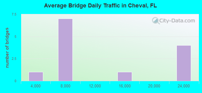
- 141,000Total average daily traffic
- 14,134Total average daily truck traffic
- National Bridge Inventory (NBI) Registered Bridges for Cheval
- No street view available for this location
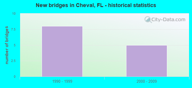
- New bridges - historical statistics
- 81990-1999
- 52000-2009
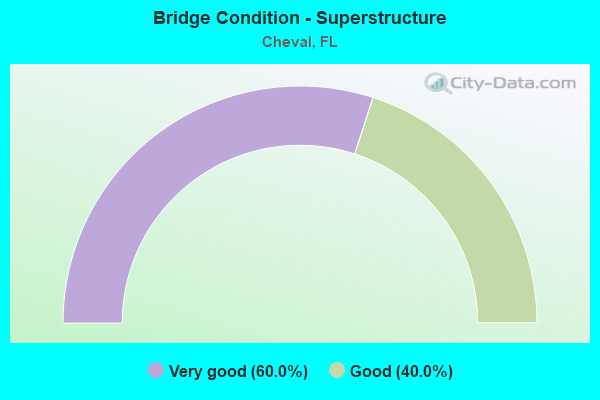
- Bridge Condition - Superstructure
- 60.0%Very good
- 40.0%Good
Find on map >> Show street view
Structure Number: 100513, Location: 0.5 MI W OF DALE MABRY (Lat: 28.134164, Lng: -82.510422), Route carried "on" structure: Spur State highway 568, Year Built: 1994, Status: Open, Structure Length: 2.56m (8.40ft), Average Daily Traffic: 6,250 (year 2020), Truck Traffic: 10%, Average Future Daily Traffic: 10,844 (year 2042), Design Load: HS 20+Mod, Features Intersected: CALUSA TRACE BLVD
Minimum Vertical Clearance: 30+ m (98+ ft), Kilometerpoint: 4.064, Lanes on structure: 2, Lanes under structure: 2, Base Highway Network: Yes, Toll: On toll road, Owner: State Toll Authority, Approaching Roadway Width: 12.6m (41.3ft), Material/Design: Prestressed concrete, Design/Construction: Stringer/Multi-beam, Number Of Spans In Main Unit: 1, Length of Maximum Span: 25.6m (84.0ft), Curb-To-Curb Width: 12.2m (40.0ft), Out-to-Out Width: 13.1m (43.0ft)
Condition: Deck: Good, Superstructure: Good, Substructure: Good, Operating Rating: 45.9 metric tons, Method Used To Determine Operating Rating: Load and Resistance Factor (LRFR), Inventory Rating: 41.3 metric tons, Method Used To Determine Inventory Rating: Load and Resistance Factor (LRFR), Structural Evaluation: Better than present minimum criteria, Deck Geometry: Better than present minimum criteria, Underclear: Superior to present desirable criteria, Approach Roadway Alignment: Equal to present desirable criteria, Designated Inspection Frequency: Every 24 months, Inspection Date: Febuary 2022, Deck Structure Type: Concrete Cast-file-Place
Find on map >> Show street view
Structure Number: 100571, Location: 1.2 MI W OF DALE MABRY (Lat: 28.132586, Lng: -82.522356), Route carried "on" structure: Spur State highway 568, Year Built: 1994, Status: Open, Structure Length: 5.93m (19.46ft), Average Daily Traffic: 6,250 (year 2020), Truck Traffic: 10%, Average Future Daily Traffic: 10,844 (year 2042), Design Load: HS 20+Mod, Features Intersected: LAKE REFLECTIONS BLVD
Minimum Vertical Clearance: 30+ m (98+ ft), Kilometerpoint: 2.853, Lanes on structure: 2, Lanes under structure: 2, Base Highway Network: Yes, Toll: On toll road, Owner: State Toll Authority, Approaching Roadway Width: 11.6m (38.1ft), Skew: 4 degrees, Material/Design: Prestressed concrete, Design/Construction: Stringer/Multi-beam, Number Of Spans In Main Unit: 3, Length of Maximum Span: 25.7m (84.3ft), Curb-To-Curb Width: 12.2m (40.0ft), Out-to-Out Width: 13.1m (43.0ft)
Condition: Deck: Good, Superstructure: Very good, Substructure: Good, Operating Rating: 37.2 metric tons, Method Used To Determine Operating Rating: Load and Resistance Factor (LRFR), Inventory Rating: 28.8 metric tons, Method Used To Determine Inventory Rating: Load and Resistance Factor (LRFR), Structural Evaluation: Better than present minimum criteria, Deck Geometry: Better than present minimum criteria, Underclear: Superior to present desirable criteria, Approach Roadway Alignment: Equal to present desirable criteria, Designated Inspection Frequency: Every 24 months, Inspection Date: Febuary 2022, Deck Structure Type: Concrete Cast-file-Place
Find on map >> Show street view
Structure Number: 100572, Location: 1.2 MI W OF DALE MABRY (Lat: 28.132328, Lng: -82.522442), Route carried "on" structure: Spur State highway 568, Year Built: 1994, Status: Open, Structure Length: 6.03m (19.78ft), Average Daily Traffic: 6,250 (year 2020), Truck Traffic: 10%, Average Future Daily Traffic: 10,844 (year 2042), Design Load: HS 20+Mod, Features Intersected: LAKE REFLECTIONS BLVD
Minimum Vertical Clearance: 30+ m (98+ ft), Kilometerpoint: 2.834, Lanes on structure: 2, Lanes under structure: 2, Base Highway Network: Yes, Toll: On toll road, Owner: State Toll Authority, Approaching Roadway Width: 11.6m (38.1ft), Skew: 4 degrees, Material/Design: Prestressed concrete, Design/Construction: Stringer/Multi-beam, Number Of Spans In Main Unit: 3, Length of Maximum Span: 26.3m (86.3ft), Curb-To-Curb Width: 12.2m (40.0ft), Out-to-Out Width: 13.1m (43.0ft)
Condition: Deck: Good, Superstructure: Very good, Substructure: Good, Operating Rating: 32.3 metric tons, Method Used To Determine Operating Rating: Load and Resistance Factor (LRFR), Inventory Rating: 24.9 metric tons, Method Used To Determine Inventory Rating: Load and Resistance Factor (LRFR), Structural Evaluation: Equal to present minimum criteria, Deck Geometry: Better than present minimum criteria, Underclear: Superior to present desirable criteria, Approach Roadway Alignment: Equal to present desirable criteria, Designated Inspection Frequency: Every 24 months, Inspection Date: Febuary 2022, Deck Structure Type: Concrete Cast-file-Place
Find on map >> Show street view
Structure Number: 10063, Location: 1.6 MI N OF VAN DYKE (Lat: 28.150089, Lng: -82.540642), Route carried "on" structure: State highway 589, Year Built: 2000, Status: Open, Structure Length: 3.92m (12.86ft), Average Daily Traffic: 22,150 (year 2020), Truck Traffic: 10%, Average Future Daily Traffic: 38,430 (year 2042), Design Load: HS 20+Mod, Features Intersected: TPC BLVD
Minimum Vertical Clearance: 30+ m (98+ ft), Kilometerpoint: 23.216, Lanes on structure: 2, Lanes under structure: 4, Base Highway Network: Yes, Toll: On toll road, Owner: State Toll Authority, Approaching Roadway Width: 12.2m (40.0ft), Material/Design: Prestressed concrete, Design/Construction: Stringer/Multi-beam, Number Of Spans In Main Unit: 1, Length of Maximum Span: 39.2m (128.6ft), Curb-To-Curb Width: 12.3m (40.4ft), Out-to-Out Width: 13.2m (43.3ft)
Condition: Deck: Good, Superstructure: Good, Substructure: Good, Operating Rating: 43.3 metric tons, Method Used To Determine Operating Rating: Load and Resistance Factor (LRFR), Inventory Rating: 39.3 metric tons, Method Used To Determine Inventory Rating: Load and Resistance Factor (LRFR), Structural Evaluation: Better than present minimum criteria, Deck Geometry: Better than present minimum criteria, Underclear: Superior to present desirable criteria, Approach Roadway Alignment: Equal to present desirable criteria, Designated Inspection Frequency: Every 24 months, Inspection Date: March 2020, Deck Structure Type: Concrete Cast-file-Place
Find on map >> Show street view
Structure Number: 100631, Location: 1.6 MI N OF VAN DYKE (Lat: 28.150256, Lng: -82.540842), Route carried "on" structure: State highway 589, Year Built: 2000, Status: Open, Structure Length: 3.92m (12.86ft), Average Daily Traffic: 22,150 (year 2020), Truck Traffic: 10%, Average Future Daily Traffic: 38,430 (year 2042), Design Load: HS 20+Mod, Features Intersected: TPC BLVD
Minimum Vertical Clearance: 30+ m (98+ ft), Kilometerpoint: 23.216, Lanes on structure: 2, Lanes under structure: 4, Base Highway Network: Yes, Toll: On toll road, Owner: State Toll Authority, Approaching Roadway Width: 12.3m (40.4ft), Material/Design: Prestressed concrete, Design/Construction: Stringer/Multi-beam, Number Of Spans In Main Unit: 1, Length of Maximum Span: 39.2m (128.6ft), Curb-To-Curb Width: 12.3m (40.4ft), Out-to-Out Width: 13.2m (43.3ft)
Condition: Deck: Good, Superstructure: Very good, Substructure: Good, Operating Rating: 43.3 metric tons, Method Used To Determine Operating Rating: Load and Resistance Factor (LRFR), Inventory Rating: 39.3 metric tons, Method Used To Determine Inventory Rating: Load and Resistance Factor (LRFR), Structural Evaluation: Better than present minimum criteria, Deck Geometry: Better than present minimum criteria, Underclear: Better than present minimum criteria, Approach Roadway Alignment: Equal to present desirable criteria, Designated Inspection Frequency: Every 24 months, Inspection Date: March 2020, Deck Structure Type: Concrete Cast-file-Place
Find on map >> Show street view
Structure Number: 104297, Location: .3 MI NW OF CALUSA TRC BL (Lat: 28.142008, Lng: -82.510464), Route carried "on" structure: County highway , Year Built: 1997, Status: Open, Structure Length: 1.28m (4.20ft), Average Daily Traffic: 150 (year 2021), Truck Traffic: 1%, Average Future Daily Traffic: 188 (year 2041), Design Load: HS 20+Mod, Features Intersected: DRAINAGE DITCH, Facility Carried by Structure: BITTERN AVENUE
Minimum Vertical Clearance: 30+ m (98+ ft), Kilometerpoint: 0.000, Lanes on structure: 2, Owner: County Highway Agency, Approaching Roadway Width: 7.6m (24.9ft), Material/Design: Concrete, Design/Construction: Culvert, Number Of Spans In Main Unit: 2, Length of Maximum Span: 6.4m (21.0ft)
Condition: Channel: Good, Culverts: Good, Operating Rating: 43.5 metric tons, Method Used To Determine Operating Rating: Load Factor (LF), Inventory Rating: 26.0 metric tons, Method Used To Determine Inventory Rating: Load Factor (LF), Structural Evaluation: Equal to present minimum criteria, Waterway Adequacy: Better than present minimum criteria, Approach Roadway Alignment: Equal to present desirable criteria, Designated Inspection Frequency: Every 24 months, Underwater Inspection Frequency: Every 24 months, Inspection Date: April 2021, Underwater Inspection Date: March 2021
Find on map >> Show street view
Structure Number: 104607, Location: 0.3Mi N ofLutz Lk.Fern Rd (Lat: 28.160194, Lng: -82.495197), Route carried "on" structure: County highway , Year Built: 2006, Status: Open, Structure Length: 1.05m (3.44ft), Average Daily Traffic: 12,000 (year 2020), Truck Traffic: 13%, Average Future Daily Traffic: 20,820 (year 2042), Design Load: HL 93, Features Intersected: Sun Lake Canal, Facility Carried by Structure: Sun Lake Blvd.
Minimum Vertical Clearance: 30+ m (98+ ft), Kilometerpoint: 0.563, Lanes on structure: 4, Owner: County Highway Agency, Approaching Roadway Width: 7.3m (24.0ft), Skew: 20 degrees, Material/Design: Concrete, Design/Construction: Culvert, Number Of Spans In Main Unit: 2, Length of Maximum Span: 4.9m (16.1ft), Curb or Sidewalk Widths: Left: 5.0m (16.4ft), Right: 5.0m (16.4ft)
Condition: Channel: Good, Culverts: Good, Operating Rating: 33.9 metric tons, Method Used To Determine Operating Rating: Load and Resistance Factor (LRFR), Inventory Rating: 26.1 metric tons, Method Used To Determine Inventory Rating: Load and Resistance Factor (LRFR), Structural Evaluation: Equal to present minimum criteria, Waterway Adequacy: Equal to present desirable criteria, Approach Roadway Alignment: Equal to present desirable criteria, Designated Inspection Frequency: Every 24 months, Underwater Inspection Frequency: Every 24 months, Inspection Date: September 2021, Underwater Inspection Date: August 2021
Find on map >> Show street view
Structure Number: 100512, Location: 0.5 MI W OF DALE MABRY (Lat: 28.134356, Lng: -82.510389), Route carried "under" structure: City street , Year Built: 1994, Structure Length: 0. m, Average Daily Traffic: 5,950 (year 2018), Truck Traffic: 9%, Features Intersected: CALUSA TRACE BLVD, Facility Carried by Structure: SR 568 SPUR WB 2.5
Minimum Vertical Clearance: 5.11m (16.77ft), Kilometerpoint: 0.000, Lanes on structure: 2, Lanes under structure: 2, Material/Design: Prestressed concrete, Design/Construction: Stringer/Multi-beam, Length of Maximum Span: 25.6m (84.0ft)
Find on map >> Show street view
Structure Number: 100513, Location: 0.5 MI W OF DALE MABRY (Lat: 28.134164, Lng: -82.510422), Route carried "under" structure: City street , Year Built: 1994, Structure Length: 0. m, Average Daily Traffic: 5,950 (year 2018), Truck Traffic: 9%, Features Intersected: CALUSA TRACE BLVD, Facility Carried by Structure: SR 568 SPUR EB 2.5
Minimum Vertical Clearance: 5.13m (16.83ft), Kilometerpoint: 0.000, Lanes on structure: 2, Lanes under structure: 2, Material/Design: Prestressed concrete, Design/Construction: Stringer/Multi-beam, Length of Maximum Span: 25.6m (84.0ft)
Find on map >> Show street view
Structure Number: 100571, Location: 1.2 MI W OF DALE MABRY (Lat: 28.132586, Lng: -82.522356), Route carried "under" structure: City street , Year Built: 1994, Structure Length: 0. m, Average Daily Traffic: 4,800 (year 2014), Truck Traffic: 8%, Features Intersected: LAKE REFLECTIONS BLVD, Facility Carried by Structure: SR 568 SPUR WB 1.8
Minimum Vertical Clearance: 5.79m (19.00ft), Kilometerpoint: 0.000, Lanes on structure: 2, Lanes under structure: 2, Material/Design: Prestressed concrete, Design/Construction: Stringer/Multi-beam, Length of Maximum Span: 25.7m (84.3ft)
Find on map >> Show street view
Structure Number: 100572, Location: 1.2 MI W OF DALE MABRY (Lat: 28.132328, Lng: -82.522442), Route carried "under" structure: City street , Year Built: 1994, Structure Length: 0. m, Average Daily Traffic: 4,800 (year 2014), Truck Traffic: 8%, Features Intersected: LAKE REFLECTIONS BLVD, Facility Carried by Structure: SR 568 SPUR EB 1.8
Minimum Vertical Clearance: 5.16m (16.93ft), Kilometerpoint: 0.000, Lanes on structure: 2, Lanes under structure: 2, Material/Design: Prestressed concrete, Design/Construction: Stringer/Multi-beam, Length of Maximum Span: 26.3m (86.3ft)
Find on map >> Show street view
Structure Number: 10063, Location: 1.6 MI N OF VAN DYKE (Lat: 28.150089, Lng: -82.540642), Route carried "under" structure: County highway , Year Built: 2000, Structure Length: 0. m, Average Daily Traffic: 22,150 (year 2020), Truck Traffic: 10%, Features Intersected: TPC BLVD, Facility Carried by Structure: SR 589 NB SCP 15.8
Minimum Vertical Clearance: 5.03m (16.50ft), Kilometerpoint: 23.181, Lanes on structure: 2, Lanes under structure: 4, Material/Design: Prestressed concrete, Design/Construction: Stringer/Multi-beam, Length of Maximum Span: 39.2m (128.6ft)
Find on map >> Show street view
Structure Number: 100631, Location: 1.6 MI N OF VAN DYKE (Lat: 28.150256, Lng: -82.540842), Route carried "under" structure: County highway , Year Built: 2000, Structure Length: 0. m, Average Daily Traffic: 22,150 (year 2020), Truck Traffic: 10%, Features Intersected: TPC BLVD, Facility Carried by Structure: SR 589 SB SCP 15.8
Minimum Vertical Clearance: 4.90m (16.08ft), Kilometerpoint: 23.210, Lanes on structure: 2, Lanes under structure: 4, Material/Design: Prestressed concrete, Design/Construction: Stringer/Multi-beam, Length of Maximum Span: 39.2m (128.6ft)