Bridge Statistics for Chevy Chase Heights, Pennsylvania (PA)
Condition, Traffic, Stress, Structural Evaluation, Project Costs
- National Bridge Inventory (NBI) Statistics
- 21Number of bridges
- 190ft / 58.4mTotal length
- $9,073,000Total costs
- 80,526Total average daily traffic
- 7,340Total average daily truck traffic
- National Bridge Inventory (NBI) Registered Bridges for Chevy Chase Heights
- No street view available for this location
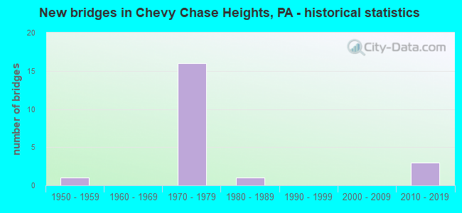
- New bridges - historical statistics
- 11950-1959
- 161970-1979
- 11980-1989
- 32010-2019

- Reconstructed bridges - Historical Statistics
- 11970-1979
- 01980-1989
- 01990-1999
- 02000-2009
- 22010-2019


- Bridge Condition - Deck
- 22.2%Very good
- 11.1%Good
- 22.2%Satisfactory
- 44.4%Fair

- Bridge Condition - Superstructure
- 22.2%Excellent
- 11.1%Good
- 22.2%Satisfactory
- 44.4%Fair

- Bridge Condition - Substructure
- 33.3%Good
- 22.2%Satisfactory
- 44.4%Fair

- Bridge Condition - Channel
- 33.3%Good
- 66.7%Fair
Find on map >> Show street view
Structure Number: 19001, Location: DRILLERS (Lat: 40.667250, Lng: -79.115314), Route carried "on" structure: State highway 110, Year Built: 1970, Status: Open, Structure Length: 0.67m (2.20ft), Average Daily Traffic: 4,685 (year 2021), Truck Traffic: 6%, Average Future Daily Traffic: 6,756 (year 2032), Design Load: HS 20, Features Intersected: McKEE RUN
Minimum Vertical Clearance: 30+ m (98+ ft), Kilometerpoint: 8.805, Lanes on structure: 6, Base Highway Network: Yes, Owner: State Highway Agency, Approaching Roadway Width: 33.2m (108.9ft), Skew: 33 degrees, Material/Design: Concrete, Design/Construction: Culvert, Number Of Spans In Main Unit: 1, Length of Maximum Span: 6.7m (22.0ft)
Condition: Channel: Fair, Culverts: Fair, Operating Rating: 46.3 metric tons, Method Used To Determine Operating Rating: Field evaluation and documented engineering judgment, Inventory Rating: 28.1 metric tons, Method Used To Determine Inventory Rating: Field evaluation and documented engineering judgment, Structural Evaluation: Somewhat better than minimum adequacy, Waterway Adequacy: Superior to present desirable criteria, Approach Roadway Alignment: Equal to present desirable criteria, Length Of Structure Improvement: 1.30m (4.27ft), Designated Inspection Frequency: Every 24 months, Inspection Date: Febuary 2021, Bridge Improvement Cost: $29,000, Roadway Improvement Cost: $86,000, Total Project Cost: $395,000
Find on map >> Show street view
Structure Number: 19033, Location: HAMILL NB (Lat: 40.638494, Lng: -79.117461), Route carried "on" structure: US 119, Year Built: 1970, Status: Open, Structure Length: 7.86m (25.79ft), Average Daily Traffic: 2,981 (year 2022), Truck Traffic: 11%, Average Future Daily Traffic: 3,801 (year 2032), Design Load: HS 20, Features Intersected: SR0286
Minimum Vertical Clearance: 30+ m (98+ ft), Kilometerpoint: 24.943, Lanes on structure: 2, Lanes under structure: 2, Base Highway Network: Yes, Owner: State Highway Agency, Approaching Roadway Width: 12.2m (40.0ft), Skew: 14 degrees, Material/Design: Steel, Design/Construction: Stringer/Multi-beam, Number Of Spans In Main Unit: 1, Number Of Approach Spans: 2, Length of Maximum Span: 37.2m (122.0ft), Curb or Sidewalk Widths: Left: 0.2m (0.7ft), Right: 0.2m (0.7ft), Curb-To-Curb Width: 12.2m (40.0ft), Out-to-Out Width: 13.4m (44.0ft)
Condition: Deck: Fair, Superstructure: Fair, Substructure: Fair, Operating Rating: 62.6 metric tons, Method Used To Determine Operating Rating: Load Factor (LF), Inventory Rating: 37.2 metric tons, Method Used To Determine Inventory Rating: Load Factor (LF), Structural Evaluation: Somewhat better than minimum adequacy, Deck Geometry: Better than present minimum criteria, Underclear: Equal to present minimum criteria, Approach Roadway Alignment: Equal to present desirable criteria, Length Of Structure Improvement: 8.80m (28.87ft), Designated Inspection Frequency: Every 24 months, Inspection Date: May 2021, Bridge Improvement Cost: $16,000, Roadway Improvement Cost: $68,000, Total Project Cost: $219,000, Deck Structure Type: Concrete Cast-file-Place, Wearing Surface/Protective System: Wearing Surface: Bituminous, Membrane: Preformed Fabric
Find on map >> Show street view
Structure Number: 19034, Location: HAMILL SB (Lat: 40.638439, Lng: -79.117869), Route carried "on" structure: US 119, Year Built: 1970, Status: Open, Structure Length: 7.07m (23.20ft), Average Daily Traffic: 2,904 (year 2022), Truck Traffic: 11%, Average Future Daily Traffic: 3,906 (year 2032), Design Load: HS 20, Features Intersected: SR0286
Minimum Vertical Clearance: 30+ m (98+ ft), Kilometerpoint: 24.885, Lanes on structure: 2, Lanes under structure: 2, Base Highway Network: Yes, Owner: State Highway Agency, Approaching Roadway Width: 12.2m (40.0ft), Skew: 14 degrees, Material/Design: Steel, Design/Construction: Stringer/Multi-beam, Number Of Spans In Main Unit: 1, Number Of Approach Spans: 2, Length of Maximum Span: 37.2m (122.0ft), Curb or Sidewalk Widths: Left: 0.2m (0.7ft), Right: 0.2m (0.7ft), Curb-To-Curb Width: 12.2m (40.0ft), Out-to-Out Width: 13.4m (44.0ft)
Condition: Deck: Fair, Superstructure: Fair, Substructure: Fair, Operating Rating: 65.3 metric tons, Method Used To Determine Operating Rating: Load Factor (LF), Inventory Rating: 39.0 metric tons, Method Used To Determine Inventory Rating: Load Factor (LF), Structural Evaluation: Somewhat better than minimum adequacy, Deck Geometry: Better than present minimum criteria, Underclear: Equal to present minimum criteria, Approach Roadway Alignment: Equal to present desirable criteria, Length Of Structure Improvement: 8.00m (26.25ft), Designated Inspection Frequency: Every 24 months, Inspection Date: May 2021, Bridge Improvement Cost: $17,000, Roadway Improvement Cost: $69,000, Total Project Cost: $224,000, Deck Structure Type: Concrete Cast-file-Place, Wearing Surface/Protective System: Wearing Surface: Bituminous, Membrane: Preformed Fabric
Find on map >> Show street view
Structure Number: 19035, Location: LUTZ SCHOOL RD NB (Lat: 40.655642, Lng: -79.115178), Route carried "on" structure: US 119, Year Built: 1970, Status: Open, Structure Length: 6.34m (20.80ft), Average Daily Traffic: 2,981 (year 2022), Truck Traffic: 11%, Average Future Daily Traffic: 3,801 (year 2032), Design Load: HS 20, Features Intersected: SR1003
Minimum Vertical Clearance: 30+ m (98+ ft), Kilometerpoint: 26.863, Lanes on structure: 2, Lanes under structure: 2, Base Highway Network: Yes, Owner: State Highway Agency, Approaching Roadway Width: 11.6m (38.1ft), Skew: 15 degrees, Material/Design: Steel, Design/Construction: Stringer/Multi-beam, Number Of Spans In Main Unit: 1, Number Of Approach Spans: 2, Length of Maximum Span: 29.9m (98.1ft), Curb or Sidewalk Widths: Left: 0.2m (0.7ft), Right: 0.2m (0.7ft), Curb-To-Curb Width: 12.3m (40.4ft), Out-to-Out Width: 13.4m (44.0ft)
Condition: Deck: Fair, Superstructure: Fair, Substructure: Fair, Operating Rating: 59.0 metric tons, Method Used To Determine Operating Rating: Load Factor (LF), Inventory Rating: 35.4 metric tons, Method Used To Determine Inventory Rating: Load Factor (LF), Structural Evaluation: Somewhat better than minimum adequacy, Deck Geometry: Better than present minimum criteria, Underclear: Equal to present minimum criteria, Approach Roadway Alignment: Equal to present desirable criteria, Length Of Structure Improvement: 7.30m (23.95ft), Designated Inspection Frequency: Every 24 months, Inspection Date: June 2021, Deck Structure Type: Concrete Cast-file-Place, Wearing Surface/Protective System: Wearing Surface: Bituminous, Membrane: Preformed Fabric
Find on map >> Show street view
Structure Number: 19036, Location: LUTZ SCHOOL RD SB (Lat: 40.655986, Lng: -79.115517), Route carried "on" structure: US 119, Year Built: 1970, Status: Open, Structure Length: 5.43m (17.81ft), Average Daily Traffic: 2,904 (year 2022), Truck Traffic: 11%, Average Future Daily Traffic: 3,906 (year 2032), Design Load: HS 20, Features Intersected: SR1003
Minimum Vertical Clearance: 30+ m (98+ ft), Kilometerpoint: 26.895, Lanes on structure: 2, Lanes under structure: 2, Base Highway Network: Yes, Owner: State Highway Agency, Approaching Roadway Width: 11.6m (38.1ft), Skew: 15 degrees, Material/Design: Steel, Design/Construction: Stringer/Multi-beam, Number Of Spans In Main Unit: 1, Number Of Approach Spans: 2, Length of Maximum Span: 25.9m (85.0ft), Curb or Sidewalk Widths: Left: 0.2m (0.7ft), Right: 0.2m (0.7ft), Curb-To-Curb Width: 12.2m (40.0ft), Out-to-Out Width: 13.4m (44.0ft)
Condition: Deck: Fair, Superstructure: Fair, Substructure: Fair, Operating Rating: 59.0 metric tons, Method Used To Determine Operating Rating: Load Factor (LF), Inventory Rating: 35.4 metric tons, Method Used To Determine Inventory Rating: Load Factor (LF), Structural Evaluation: Somewhat better than minimum adequacy, Deck Geometry: Better than present minimum criteria, Underclear: Equal to present minimum criteria, Approach Roadway Alignment: Equal to present desirable criteria, Length Of Structure Improvement: 6.30m (20.67ft), Designated Inspection Frequency: Every 24 months, Inspection Date: June 2021, Deck Structure Type: Concrete Cast-file-Place, Wearing Surface/Protective System: Wearing Surface: Bituminous, Membrane: Preformed Fabric
Find on map >> Show street view
Structure Number: 19038, Location: BLAIS NB (Lat: 40.667531, Lng: -79.113103), Route carried "on" structure: US 119, Year Built: 1970, Year Reconstructed: 2016, Status: Open, Structure Length: 3.08m (10.10ft), Average Daily Traffic: 2,981 (year 2022), Truck Traffic: 11%, Average Future Daily Traffic: 3,801 (year 2032), Design Load: HS 20, Features Intersected: SR0110 EB&WB
Minimum Vertical Clearance: 30+ m (98+ ft), Kilometerpoint: 27.808, Lanes on structure: 2, Lanes under structure: 2, Base Highway Network: Yes, Owner: State Highway Agency, Approaching Roadway Width: 11.6m (38.1ft), Skew: 11 degrees, Material/Design: Steel, Design/Construction: Stringer/Multi-beam, Number Of Spans In Main Unit: 1, Length of Maximum Span: 29.9m (98.1ft), Curb or Sidewalk Widths: Left: 0.2m (0.7ft), Right: 0.2m (0.7ft), Curb-To-Curb Width: 12.2m (40.0ft), Out-to-Out Width: 13.2m (43.3ft)
Condition: Deck: Very good, Superstructure: Excellent, Substructure: Good, Operating Rating: 86.2 metric tons, Method Used To Determine Operating Rating: Load Factor (LF), Inventory Rating: 51.7 metric tons, Method Used To Determine Inventory Rating: Load Factor (LF), Structural Evaluation: Better than present minimum criteria, Deck Geometry: Better than present minimum criteria, Underclear: Somewhat better than minimum adequacy, Approach Roadway Alignment: Equal to present desirable criteria, Length Of Structure Improvement: 3.80m (12.47ft), Designated Inspection Frequency: Every 48 months, Inspection Date: September 2021, Bridge Improvement Cost: $33,000, Roadway Improvement Cost: $96,000, Total Project Cost: $442,000, Deck Structure Type: Concrete Cast-file-Place, Wearing Surface/Protective System: Wearing Surface: Monolithic Concrete, Deck Protection: Epoxy Coated Reinforcing
Find on map >> Show street view
Structure Number: 19039, Location: MABON (Lat: 40.671767, Lng: -79.112764), Route carried "on" structure: US 119, Year Built: 1970, Status: Open, Structure Length: 0.64m (2.10ft), Average Daily Traffic: 6,666 (year 2021), Truck Traffic: 12%, Average Future Daily Traffic: 7,445 (year 2032), Design Load: HS 20, Features Intersected: McKEE RUN
Minimum Vertical Clearance: 30+ m (98+ ft), Kilometerpoint: 28.592, Lanes on structure: 4, Base Highway Network: Yes, Owner: State Highway Agency, Approaching Roadway Width: 28.3m (92.8ft), Skew: 6 degrees, Material/Design: Steel, Design/Construction: Culvert, Number Of Spans In Main Unit: 1, Length of Maximum Span: 6.4m (21.0ft)
Condition: Channel: Fair, Culverts: Fair, Operating Rating: 49.0 metric tons, Method Used To Determine Operating Rating: Field evaluation and documented engineering judgment, Inventory Rating: 32.7 metric tons, Method Used To Determine Inventory Rating: Field evaluation and documented engineering judgment, Structural Evaluation: Somewhat better than minimum adequacy, Waterway Adequacy: Superior to present desirable criteria, Approach Roadway Alignment: Equal to present desirable criteria, Length Of Structure Improvement: 1.20m (3.94ft), Designated Inspection Frequency: Every 24 months, Inspection Date: July 2021
Find on map >> Show street view
Structure Number: 1904, Location: BLAIS SB (Lat: 40.667456, Lng: -79.113522), Route carried "on" structure: US 119, Year Built: 1970, Year Reconstructed: 2016, Status: Open, Structure Length: 3.08m (10.10ft), Average Daily Traffic: 4,056 (year 2021), Truck Traffic: 11%, Average Future Daily Traffic: 3,569 (year 2032), Design Load: HS 20, Features Intersected: SR0110 EB&WB
Minimum Vertical Clearance: 30+ m (98+ ft), Kilometerpoint: 27.795, Lanes on structure: 2, Lanes under structure: 2, Base Highway Network: Yes, Owner: State Highway Agency, Approaching Roadway Width: 11.6m (38.1ft), Skew: 11 degrees, Material/Design: Steel, Design/Construction: Stringer/Multi-beam, Number Of Spans In Main Unit: 1, Length of Maximum Span: 29.9m (98.1ft), Curb or Sidewalk Widths: Left: 0.2m (0.7ft), Right: 0.2m (0.7ft), Curb-To-Curb Width: 12.2m (40.0ft), Out-to-Out Width: 13.2m (43.3ft)
Condition: Deck: Very good, Superstructure: Excellent, Substructure: Good, Operating Rating: 86.2 metric tons, Method Used To Determine Operating Rating: Load Factor (LF), Inventory Rating: 51.7 metric tons, Method Used To Determine Inventory Rating: Load Factor (LF), Structural Evaluation: Better than present minimum criteria, Deck Geometry: Better than present minimum criteria, Underclear: Somewhat better than minimum adequacy, Approach Roadway Alignment: Equal to present desirable criteria, Length Of Structure Improvement: 3.80m (12.47ft), Designated Inspection Frequency: Every 48 months, Inspection Date: September 2021, Bridge Improvement Cost: $21,000, Roadway Improvement Cost: $61,000, Total Project Cost: $279,000, Deck Structure Type: Concrete Cast-file-Place, Wearing Surface/Protective System: Wearing Surface: Monolithic Concrete, Deck Protection: Epoxy Coated Reinforcing
Find on map >> Show street view
Structure Number: 19194, Location: MARTIN ROAD (Lat: 40.635894, Lng: -79.157214), Route carried "on" structure: State highway 954, Year Built: 1985, Status: Open, Structure Length: 1.68m (5.51ft), Average Daily Traffic: 1,451 (year 2022), Truck Traffic: 2%, Average Future Daily Traffic: 751 (year 2032), Design Load: HS 20+Mod, Features Intersected: BUFF & PITT RR
Minimum Vertical Clearance: 30+ m (98+ ft), Kilometerpoint: 11.674, Lanes on structure: 2, Owner: State Highway Agency, Approaching Roadway Width: 11.9m (39.0ft), Skew: 3 degrees, Material/Design: Prestressed concrete, Design/Construction: Box Beam or Girders - Single/Spread, Number Of Spans In Main Unit: 1, Length of Maximum Span: 16.2m (53.1ft), Curb or Sidewalk Widths: Left: 0.2m (0.7ft), Right: 0.2m (0.7ft), Curb-To-Curb Width: 13.7m (44.9ft), Out-to-Out Width: 14.8m (48.6ft)
Condition: Deck: Satisfactory, Superstructure: Satisfactory, Substructure: Satisfactory, Operating Rating: 89.8 metric tons, Method Used To Determine Operating Rating: Load Factor (LF), Inventory Rating: 43.5 metric tons, Method Used To Determine Inventory Rating: Load Factor (LF), Structural Evaluation: Equal to present minimum criteria, Deck Geometry: Superior to present desirable criteria, Underclear: High priority of corrective action, Approach Roadway Alignment: Equal to present desirable criteria, Length Of Structure Improvement: 2.20m (7.22ft), Designated Inspection Frequency: Every 24 months, Inspection Date: May 2020, Deck Structure Type: Concrete Cast-file-Place, Wearing Surface/Protective System: Wearing Surface: Monolithic Concrete, Deck Protection: Epoxy Coated Reinforcing
Find on map >> Show street view
Structure Number: 22338, Location: 3/4 MI. WEST OF SR 0019 (Lat: 40.969467, Lng: -80.181272), Route carried "on" structure: US 422, Year Built: 1950, Year Reconstructed: 1984, Status: Open, Structure Length: 15.33m (50.30ft), Average Daily Traffic: 18,101 (year 2022), Truck Traffic: 11%, Average Future Daily Traffic: 12,716 (year 2032), Design Load: HS 20, Features Intersected: SLIPPERY ROCK CREEK, Facility Carried by Structure: BENJAMIN FRANKL HW
Minimum Vertical Clearance: 30+ m (98+ ft), Kilometerpoint: 33.379, Lanes on structure: 4, Base Highway Network: Yes, Owner: State Highway Agency, Approaching Roadway Width: 17.1m (56.1ft), Skew: 20 degrees, Material/Design: Concrete, Design/Construction: Arch - Deck, Number Of Spans In Main Unit: 3, Number Of Approach Spans: 3, Length of Maximum Span: 54.6m (179.1ft), Curb or Sidewalk Widths: Left: 0.9m (3.0ft), Right: 0.9m (3.0ft), Curb-To-Curb Width: 15.5m (50.9ft), Out-to-Out Width: 17.7m (58.1ft)
Condition: Deck: Satisfactory, Superstructure: Satisfactory, Substructure: Satisfactory, Channel: Good, Operating Rating: 44.5 metric tons, Method Used To Determine Operating Rating: Load Factor (LF), Inventory Rating: 26.3 metric tons, Method Used To Determine Inventory Rating: Load Factor (LF), Structural Evaluation: Equal to present minimum criteria, Deck Geometry: Meets minimum limits, Waterway Adequacy: Superior to present desirable criteria, Approach Roadway Alignment: Equal to present desirable criteria, Length Of Structure Improvement: 15.50m (50.85ft), Designated Inspection Frequency: Every 24 months, Inspection Date: September 2021, Bridge Improvement Cost: $557,000, Roadway Improvement Cost: $1,639,000, Total Project Cost: $7,514,000, Deck Structure Type: Concrete Cast-file-Place, Wearing Surface/Protective System: Wearing Surface: Monolithic Concrete
Find on map >> Show street view
Structure Number: 52591, Location: 0.2 Mi E SR 286 Inter. (Lat: 40.632947, Lng: -79.117642), Route carried "on" structure: State highway , Year Built: 2015, Status: Open, Structure Length: 7.19m (23.59ft), Average Daily Traffic: 3,267 (year 2022), Truck Traffic: 5%, Average Future Daily Traffic: 3,512 (year 2032), Design Load: HL 93, Features Intersected: SE 0119 NB & SB, Facility Carried by Structure: SR 1006
Minimum Vertical Clearance: 30+ m (98+ ft), Kilometerpoint: 0.000, Lanes on structure: 2, Lanes under structure: 4, Owner: State Highway Agency, Approaching Roadway Width: 8.5m (27.9ft), Skew: 1 degrees, Material/Design: Steel continuous, Design/Construction: Stringer/Multi-beam, Number Of Spans In Main Unit: 2, Length of Maximum Span: 35.1m (115.2ft), Curb or Sidewalk Widths: Left: 0.2m (0.7ft), Right: 0.2m (0.7ft), Curb-To-Curb Width: 12.8m (42.0ft), Out-to-Out Width: 13.8m (45.3ft)
Condition: Deck: Good, Superstructure: Good, Substructure: Good, Operating Rating: 54.8 metric tons, Method Used To Determine Operating Rating: Assigned ratings based on Load and Resistance Factor Design (LRFD) reported by rating factor (RF) using HL93 loadings, Inventory Rating: 42.1 metric tons, Method Used To Determine Inventory Rating: Assigned ratings based on Load and Resistance Factor Design (LRFD) reported by rating factor (RF) using HL93 loadings, Structural Evaluation: Better than present minimum criteria, Deck Geometry: Equal to present minimum criteria, Underclear: Equal to present minimum criteria, Approach Roadway Alignment: Equal to present desirable criteria, Designated Inspection Frequency: Every 48 months, Inspection Date: March 2021, Deck Structure Type: Concrete Cast-file-Place, Wearing Surface/Protective System: Wearing Surface: Monolithic Concrete, Deck Protection: Epoxy Coated Reinforcing
Find on map >> Show street view
Structure Number: 19033, Location: HAMILL NB (Lat: 40.638494, Lng: -79.117461), Route carried "under" structure: State highway 286, Year Built: 1970, Structure Length: 0. m, Average Daily Traffic: 7,165 (year 2020), Truck Traffic: 7%, Features Intersected: SR0286, Facility Carried by Structure: SR0119 NB
Minimum Vertical Clearance: 6.37m (20.90ft), Kilometerpoint: 37.074, Lanes on structure: 2, Lanes under structure: 2, Material/Design: Steel, Design/Construction: Stringer/Multi-beam, Length of Maximum Span: 37.2m (122.0ft)
Find on map >> Show street view
Structure Number: 19034, Location: HAMILL SB (Lat: 40.638439, Lng: -79.117869), Route carried "under" structure: State highway 286, Year Built: 1970, Structure Length: 0. m, Average Daily Traffic: 7,165 (year 2020), Truck Traffic: 7%, Features Intersected: SR0286, Facility Carried by Structure: SR0119 SB
Minimum Vertical Clearance: 5.07m (16.63ft), Kilometerpoint: 37.074, Lanes on structure: 2, Lanes under structure: 2, Material/Design: Steel, Design/Construction: Stringer/Multi-beam, Length of Maximum Span: 37.2m (122.0ft)
Find on map >> Show street view
Structure Number: 19035, Location: LUTZ SCHOOL RD NB (Lat: 40.655642, Lng: -79.115178), Route carried "under" structure: State highway , Year Built: 1970, Structure Length: 0. m, Average Daily Traffic: 489 (year 2022), Truck Traffic: 5%, Features Intersected: SR1003, Facility Carried by Structure: SR0119 NB
Minimum Vertical Clearance: 4.68m (15.35ft), Kilometerpoint: 1.020, Lanes on structure: 2, Lanes under structure: 2, Material/Design: Steel, Design/Construction: Stringer/Multi-beam, Length of Maximum Span: 29.9m (98.1ft)
Find on map >> Show street view
Structure Number: 19036, Location: LUTZ SCHOOL RD SB (Lat: 40.655986, Lng: -79.115517), Route carried "under" structure: State highway , Year Built: 1970, Structure Length: 0. m, Average Daily Traffic: 489 (year 2022), Truck Traffic: 5%, Features Intersected: SR1003, Facility Carried by Structure: SR0119 SB
Minimum Vertical Clearance: 4.72m (15.49ft), Kilometerpoint: 1.020, Lanes on structure: 2, Lanes under structure: 2, Material/Design: Steel, Design/Construction: Stringer/Multi-beam, Length of Maximum Span: 25.9m (85.0ft)
Find on map >> Show street view
Structure Number: 19038, Location: BLAIS NB (Lat: 40.667531, Lng: -79.113103), Route carried "under" structure: Ramp State highway 110, Year Built: 1970, Structure Length: 0. m, Average Daily Traffic: 1,589 (year 2021), Truck Traffic: 5%, Features Intersected: SR0110 EB&WB, Facility Carried by Structure: SR0119 NB
Minimum Vertical Clearance: 4.90m (16.08ft), Kilometerpoint: 8.805, Lanes on structure: 2, Lanes under structure: 1, Material/Design: Steel, Design/Construction: Stringer/Multi-beam, Length of Maximum Span: 29.9m (98.1ft)
Find on map >> Show street view
Structure Number: 19038, Location: BLAIS NB (Lat: 40.667531, Lng: -79.113103), Route carried "under" structure: Ramp State highway 110, Year Built: 1970, Structure Length: 0. m, Average Daily Traffic: 1,589 (year 2021), Truck Traffic: 5%, Features Intersected: SR0110 EB&WB, Facility Carried by Structure: SR0119 NB
Minimum Vertical Clearance: 4.89m (16.04ft), Kilometerpoint: 8.805, Lanes on structure: 2, Lanes under structure: 1, Material/Design: Steel, Design/Construction: Stringer/Multi-beam, Length of Maximum Span: 29.9m (98.1ft)
Find on map >> Show street view
Structure Number: 1904, Location: BLAIS SB (Lat: 40.667456, Lng: -79.113522), Route carried "under" structure: Ramp State highway 110, Year Built: 1970, Structure Length: 0. m, Average Daily Traffic: 1,589 (year 2021), Truck Traffic: 5%, Features Intersected: SR0110 EB&WB, Facility Carried by Structure: SR0119 SB
Minimum Vertical Clearance: 5.01m (16.44ft), Kilometerpoint: 8.805, Lanes on structure: 2, Lanes under structure: 1, Material/Design: Steel, Design/Construction: Stringer/Multi-beam, Length of Maximum Span: 29.9m (98.1ft)
Find on map >> Show street view
Structure Number: 1904, Location: BLAIS SB (Lat: 40.667456, Lng: -79.113522), Route carried "under" structure: Ramp State highway 110, Year Built: 1970, Structure Length: 0. m, Average Daily Traffic: 1,589 (year 2021), Truck Traffic: 5%, Features Intersected: SR0110 EB&WB, Facility Carried by Structure: SR0119 SB
Minimum Vertical Clearance: 4.91m (16.11ft), Kilometerpoint: 8.805, Lanes on structure: 2, Lanes under structure: 1, Material/Design: Steel, Design/Construction: Stringer/Multi-beam, Length of Maximum Span: 29.9m (98.1ft)
Find on map >> Show street view
Structure Number: 52591, Location: 0.2 Mi E SR 286 Inter. (Lat: 40.632947, Lng: -79.117642), Route carried "under" structure: US 119, Year Built: 2015, Structure Length: 0. m, Average Daily Traffic: 2,981 (year 2022), Truck Traffic: 11%, Features Intersected: SE 0119 NB & SB, Facility Carried by Structure: SR 1006
Minimum Vertical Clearance: 5.85m (19.19ft), Kilometerpoint: 24.372, Lanes on structure: 2, Lanes under structure: 2, Material/Design: Steel continuous, Design/Construction: Stringer/Multi-beam, Length of Maximum Span: 35.1m (115.2ft)
Find on map >> Show street view
Structure Number: 52591, Location: 0.2 Mi E SR 286 Inter. (Lat: 40.632947, Lng: -79.117642), Route carried "under" structure: US 119, Year Built: 2015, Structure Length: 0. m, Average Daily Traffic: 2,904 (year 2022), Truck Traffic: 11%, Features Intersected: SE 0119 NB & SB, Facility Carried by Structure: SR 1006
Minimum Vertical Clearance: 5.11m (16.77ft), Kilometerpoint: 24.341, Lanes on structure: 2, Lanes under structure: 2, Material/Design: Steel continuous, Design/Construction: Stringer/Multi-beam, Length of Maximum Span: 35.1m (115.2ft)