Bridge Statistics for Chillicothe, Texas (TX)
Condition, Traffic, Stress, Structural Evaluation, Project Costs
- National Bridge Inventory (NBI) Statistics
- 17Number of bridges
- 161ft / 49.5mTotal length
- 61,539Total average daily traffic
- 23,913Total average daily truck traffic
- 95,603Total future (year 2030) average daily traffic
- National Bridge Inventory (NBI) Registered Bridges for Chillicothe
- No street view available for this location
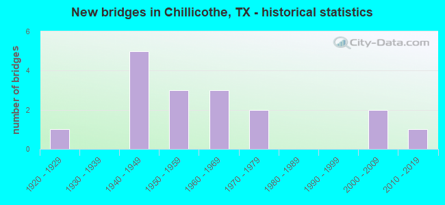
- New bridges - historical statistics
- 11920-1929
- 51940-1949
- 31950-1959
- 31960-1969
- 21970-1979
- 22000-2009
- 12010-2019

- Reconstructed bridges - Historical Statistics
- 11960-1969
- 11970-1979
- 11980-1989
- 11990-1999


- Bridge Condition - Deck
- 25.0%Good
- 75.0%Satisfactory

- Bridge Condition - Superstructure
- 25.0%Very good
- 25.0%Good
- 25.0%Satisfactory
- 25.0%Fair

- Bridge Condition - Substructure
- 50.0%Good
- 50.0%Satisfactory

- Bridge Condition - Channel
- 68.8%Good
- 18.8%Satisfactory
- 12.5%Fair

- Bridge Condition - Culverts
- 30.8%Good
- 61.5%Satisfactory
- 7.7%Fair
Find on map >> Show street view
Structure Number: 32440004305014, Location: 0.9 MI E OF FM 925 (Lat: 34.246100, Lng: -99.464536), Route carried "on" structure: US 287, Year Built: 1929, Year Reconstructed: 1989, Status: Open, Structure Length: 1.22m (4.00ft), Average Daily Traffic: 12,907 (year 2020), Truck Traffic: 45%, Average Future Daily Traffic: 18,070 (year 2040), Design Load: H 15, Features Intersected: DRAW
Minimum Vertical Clearance: 30+ m (98+ ft), Kilometerpoint: 17.144, Lanes on structure: 2, Owner: State Highway Agency, Approaching Roadway Width: 12.2m (40.0ft), Material/Design: Concrete, Design/Construction: Culvert, Number Of Spans In Main Unit: 6, Length of Maximum Span: 1.8m (5.9ft), Curb-To-Curb Width: 13.1m (43.0ft), Out-to-Out Width: 16.2m (53.1ft)
Condition: Channel: Good, Culverts: Satisfactory, Operating Rating: 22.7 metric tons, Method Used To Determine Operating Rating: No rating analysis performed, Inventory Rating: 17.0 metric tons, Method Used To Determine Inventory Rating: No rating analysis performed, Structural Evaluation: Meets minimum limits, Deck Geometry: Superior to present desirable criteria, Waterway Adequacy: Equal to present minimum criteria, Approach Roadway Alignment: Equal to present desirable criteria, Designated Inspection Frequency: Every 24 months, Inspection Date: November 2021, Deck Structure Type: Concrete Cast-file-Place, Wearing Surface/Protective System: Wearing Surface: Bituminous
Find on map >> Show street view
Structure Number: 32440004305169, Location: 0.9 MI E OF FM 925 (Lat: 34.246767, Lng: -99.464758), Route carried "on" structure: US 287, Year Built: 1976, Status: Open, Structure Length: 0.88m (2.89ft), Average Daily Traffic: 12,907 (year 2020), Truck Traffic: 45%, Average Future Daily Traffic: 18,070 (year 2040), Design Load: HS 20, Features Intersected: DRAW
Minimum Vertical Clearance: 30+ m (98+ ft), Kilometerpoint: 17.128, Lanes on structure: 3, Owner: State Highway Agency, Approaching Roadway Width: 15.2m (49.9ft), Skew: 4 degrees, Material/Design: Concrete, Design/Construction: Culvert, Number Of Spans In Main Unit: 2, Length of Maximum Span: 3.0m (9.8ft)
Condition: Channel: Good, Culverts: Good, Operating Rating: 32.7 metric tons, Method Used To Determine Operating Rating: No rating analysis performed, Inventory Rating: 24.5 metric tons, Method Used To Determine Inventory Rating: No rating analysis performed, Structural Evaluation: Equal to present minimum criteria, Waterway Adequacy: Equal to present desirable criteria, Approach Roadway Alignment: Equal to present desirable criteria, Designated Inspection Frequency: Every 24 months, Inspection Date: November 2021
Find on map >> Show street view
Structure Number: 3244000430517, Location: 4.5 MI NW OF FM 432 (Lat: 34.240689, Lng: -99.449983), Route carried "on" structure: US 287, Year Built: 1976, Status: Open, Structure Length: 7.38m (24.21ft), Average Daily Traffic: 12,235 (year 2020), Truck Traffic: 46%, Average Future Daily Traffic: 24,470 (year 2040), Design Load: HS 20, Features Intersected: BNSF RR
Minimum Vertical Clearance: 30+ m (98+ ft), Kilometerpoint: 18.599, Lanes on structure: 2, Owner: State Highway Agency, Approaching Roadway Width: 12.6m (41.3ft), Skew: 5 degrees, Material/Design: Prestressed concrete, Design/Construction: Stringer/Multi-beam, Number Of Spans In Main Unit: 3, Length of Maximum Span: 28.0m (91.9ft), Curb-To-Curb Width: 12.8m (42.0ft), Out-to-Out Width: 13.5m (44.3ft)
Condition: Deck: Good, Superstructure: Good, Substructure: Satisfactory, Operating Rating: 54.4 metric tons, Method Used To Determine Operating Rating: Assigned rating based on Load Factor Design (LFD) reported in metric tons, Inventory Rating: 32.7 metric tons, Method Used To Determine Inventory Rating: Assigned rating based on Load Factor Design (LFD) reported in metric tons, Structural Evaluation: Equal to present minimum criteria, Deck Geometry: Equal to present desirable criteria, Underclear: Equal to present minimum criteria, Approach Roadway Alignment: Equal to present desirable criteria, Length Of Structure Improvement: 7.38m (24.21ft), Designated Inspection Frequency: Every 24 months, Inspection Date: November 2021, Deck Structure Type: Concrete Cast-file-Place, Wearing Surface/Protective System: Wearing Surface: Bituminous
Find on map >> Show street view
Structure Number: 32440116202003, Location: 4.9 MI W OF FM 432 (Lat: 34.277125, Lng: -99.463064), Route carried "on" structure: State highway 924, Year Built: 1965, Status: Open, Structure Length: 1.31m (4.30ft), Average Daily Traffic: 100 (year 2020), Truck Traffic: 6%, Average Future Daily Traffic: 493 (year 2040), Design Load: HS 20, Features Intersected: DRAW
Minimum Vertical Clearance: 30+ m (98+ ft), Kilometerpoint: 1.191, Lanes on structure: 2, Owner: State Highway Agency, Approaching Roadway Width: 6.1m (20.0ft), Material/Design: Concrete, Design/Construction: Culvert, Number Of Spans In Main Unit: 4, Length of Maximum Span: 3.0m (9.8ft), Curb-To-Curb Width: 6.6m (21.7ft), Out-to-Out Width: 10.2m (33.5ft)
Condition: Channel: Good, Culverts: Satisfactory, Operating Rating: 22.7 metric tons, Method Used To Determine Operating Rating: No rating analysis performed, Inventory Rating: 17.0 metric tons, Method Used To Determine Inventory Rating: No rating analysis performed, Structural Evaluation: Somewhat better than minimum adequacy, Deck Geometry: Somewhat better than minimum adequacy, Waterway Adequacy: Better than present minimum criteria, Approach Roadway Alignment: Equal to present desirable criteria, Designated Inspection Frequency: Every 24 months, Inspection Date: November 2021, Deck Structure Type: Concrete Cast-file-Place, Wearing Surface/Protective System: Wearing Surface: Bituminous
Find on map >> Show street view
Structure Number: 32440231202003, Location: 1.3 MI S HARDEMAN CO LINE (Lat: 34.221406, Lng: -99.471211), Route carried "on" structure: State highway 925, Year Built: 1958, Year Reconstructed: 1970, Status: Open, Structure Length: 0.85m (2.79ft), Average Daily Traffic: 100 (year 2020), Truck Traffic: 13%, Average Future Daily Traffic: 123 (year 2040), Features Intersected: DRAW
Minimum Vertical Clearance: 30+ m (98+ ft), Kilometerpoint: 1.448, Lanes on structure: 2, Owner: State Highway Agency, Approaching Roadway Width: 5.9m (19.4ft), Material/Design: Concrete, Design/Construction: Culvert, Number Of Spans In Main Unit: 5, Length of Maximum Span: 1.5m (4.9ft), Curb-To-Curb Width: 5.8m (19.0ft), Out-to-Out Width: 9.0m (29.5ft)
Condition: Channel: Good, Culverts: Good, Operating Rating: 44.4 metric tons, Method Used To Determine Operating Rating: No rating analysis performed, Inventory Rating: 32.7 metric tons, Method Used To Determine Inventory Rating: No rating analysis performed, Structural Evaluation: Better than present minimum criteria, Deck Geometry: Meets minimum limits, Waterway Adequacy: Better than present minimum criteria, Approach Roadway Alignment: Equal to present desirable criteria, Designated Inspection Frequency: Every 24 months, Inspection Date: November 2021, Deck Structure Type: Concrete Cast-file-Place, Wearing Surface/Protective System: Wearing Surface: Bituminous
Find on map >> Show street view
Structure Number: 251000004304114, Location: 0.71 MI W OF FM 91 (Lat: 34.255736, Lng: -99.528597), Route carried "on" structure: US 287, Year Built: 1965, Year Reconstructed: 2003, Status: Open, Structure Length: 1.31m (4.30ft), Average Daily Traffic: 10,692 (year 2019), Truck Traffic: 30%, Average Future Daily Traffic: 16,440 (year 2033), Design Load: HS 20, Features Intersected: WANDERERS CREEK REL
Minimum Vertical Clearance: 30+ m (98+ ft), Kilometerpoint: 45.784, Lanes on structure: 4, Owner: State Highway Agency, Approaching Roadway Width: 25.0m (82.0ft), Skew: 30 degrees, Material/Design: Concrete, Design/Construction: Culvert, Number Of Spans In Main Unit: 5, Length of Maximum Span: 2.4m (7.9ft)
Condition: Channel: Good, Culverts: Good, Operating Rating: 39.9 metric tons, Method Used To Determine Operating Rating: Load Factor (LF), Inventory Rating: 23.6 metric tons, Method Used To Determine Inventory Rating: Load Factor (LF), Structural Evaluation: Somewhat better than minimum adequacy, Waterway Adequacy: Superior to present desirable criteria, Approach Roadway Alignment: Equal to present desirable criteria, Designated Inspection Frequency: Every 24 months, Inspection Date: April 2021
Find on map >> Show street view
Structure Number: 251000004304201, Location: 0.60 MI W OF FM 91 (Lat: 34.256056, Lng: -99.527250), Route carried "on" structure: US 287, Year Built: 2003, Status: Open, Structure Length: 7.77m (25.49ft), Average Daily Traffic: 10,692 (year 2019), Truck Traffic: 30%, Average Future Daily Traffic: 16,440 (year 2033), Design Load: HS 20, Features Intersected: WANDERERS CREEK
Minimum Vertical Clearance: 30+ m (98+ ft), Kilometerpoint: 45.915, Lanes on structure: 4, Owner: State Highway Agency, Approaching Roadway Width: 25.0m (82.0ft), Skew: 30 degrees, Material/Design: Prestressed concrete, Design/Construction: Stringer/Multi-beam, Number Of Spans In Main Unit: 4, Length of Maximum Span: 22.9m (75.1ft), Curb-To-Curb Width: 24.9m (81.7ft), Out-to-Out Width: 26.2m (86.0ft)
Condition: Deck: Satisfactory, Superstructure: Very good, Substructure: Good, Channel: Good, Operating Rating: 54.4 metric tons, Method Used To Determine Operating Rating: Assigned rating based on Load Factor Design (LFD) reported in metric tons, Inventory Rating: 32.7 metric tons, Method Used To Determine Inventory Rating: Assigned rating based on Load Factor Design (LFD) reported in metric tons, Structural Evaluation: Better than present minimum criteria, Deck Geometry: Superior to present desirable criteria, Waterway Adequacy: Superior to present desirable criteria, Approach Roadway Alignment: Equal to present desirable criteria, Designated Inspection Frequency: Every 24 months, Inspection Date: April 2021, Deck Structure Type: Concrete Precast Panels
Find on map >> Show street view
Structure Number: 251000070202014, Location: 0.64 MI S OF FM 91 (Lat: 34.203019, Lng: -99.519586), Route carried "on" structure: State highway 392, Year Built: 1940, Year Reconstructed: 1966, Status: Open, Structure Length: 0.79m (2.59ft), Average Daily Traffic: 613 (year 2019), Truck Traffic: 10%, Average Future Daily Traffic: 430 (year 2034), Features Intersected: DRAW
Minimum Vertical Clearance: 30+ m (98+ ft), Kilometerpoint: 15.659, Lanes on structure: 2, Owner: State Highway Agency, Approaching Roadway Width: 6.1m (20.0ft), Material/Design: Concrete, Design/Construction: Culvert, Number Of Spans In Main Unit: 4, Length of Maximum Span: 1.8m (5.9ft), Curb-To-Curb Width: 7.0m (23.0ft), Out-to-Out Width: 10.2m (33.5ft)
Condition: Channel: Good, Culverts: Satisfactory, Operating Rating: 32.7 metric tons, Method Used To Determine Operating Rating: Field evaluation and documented engineering judgment, Inventory Rating: 24.5 metric tons, Method Used To Determine Inventory Rating: Field evaluation and documented engineering judgment, Structural Evaluation: Equal to present minimum criteria, Deck Geometry: Meets minimum limits, Waterway Adequacy: Equal to present minimum criteria, Approach Roadway Alignment: Equal to present desirable criteria, Designated Inspection Frequency: Every 24 months, Inspection Date: April 2021, Deck Structure Type: Concrete Cast-file-Place, Wearing Surface/Protective System: Wearing Surface: Bituminous
Find on map >> Show street view
Structure Number: 251000070202017, Location: 3.2 MI W OF WILBARGER C/L (Lat: 34.278725, Lng: -99.508058), Route carried "on" structure: State highway 91, Year Built: 2006, Status: Open, Structure Length: 9.75m (31.99ft), Average Daily Traffic: 584 (year 2020), Truck Traffic: 16%, Average Future Daily Traffic: 500 (year 2033), Design Load: HS 20, Features Intersected: WANDERERS CREEK
Minimum Vertical Clearance: 30+ m (98+ ft), Kilometerpoint: 15.759, Lanes on structure: 2, Owner: State Highway Agency, Approaching Roadway Width: 6.1m (20.0ft), Material/Design: Concrete, Design/Construction: Stringer/Multi-beam, Number Of Spans In Main Unit: 8, Length of Maximum Span: 12.2m (40.0ft), Curb-To-Curb Width: 9.7m (31.8ft), Out-to-Out Width: 10.4m (34.1ft)
Condition: Deck: Satisfactory, Superstructure: Satisfactory, Substructure: Good, Channel: Good, Operating Rating: 54.4 metric tons, Method Used To Determine Operating Rating: Assigned rating based on Load Factor Design (LFD) reported in metric tons, Inventory Rating: 32.7 metric tons, Method Used To Determine Inventory Rating: Assigned rating based on Load Factor Design (LFD) reported in metric tons, Structural Evaluation: Equal to present minimum criteria, Deck Geometry: Equal to present minimum criteria, Waterway Adequacy: Equal to present minimum criteria, Approach Roadway Alignment: Equal to present desirable criteria, Designated Inspection Frequency: Every 24 months, Inspection Date: April 2021, Deck Structure Type: Concrete Cast-file-Place
Find on map >> Show street view
Structure Number: 251000070204012, Location: 1.05 MI W OF FM 392 (Lat: 34.207761, Lng: -99.540217), Route carried "on" structure: State highway 91, Year Built: 1956, Status: Open, Structure Length: 1.83m (6.00ft), Average Daily Traffic: 164 (year 2020), Truck Traffic: 33%, Average Future Daily Traffic: 140 (year 2033), Features Intersected: DRAW
Minimum Vertical Clearance: 30+ m (98+ ft), Kilometerpoint: 6.468, Lanes on structure: 2, Owner: State Highway Agency, Approaching Roadway Width: 6.1m (20.0ft), Material/Design: Concrete, Design/Construction: Culvert, Number Of Spans In Main Unit: 9, Length of Maximum Span: 1.8m (5.9ft), Curb-To-Curb Width: 7.3m (24.0ft), Out-to-Out Width: 7.9m (25.9ft)
Condition: Channel: Good, Culverts: Satisfactory, Operating Rating: 39.9 metric tons, Method Used To Determine Operating Rating: Load Factor (LF), Inventory Rating: 23.6 metric tons, Method Used To Determine Inventory Rating: Load Factor (LF), Structural Evaluation: Equal to present minimum criteria, Deck Geometry: Somewhat better than minimum adequacy, Waterway Adequacy: Equal to present minimum criteria, Approach Roadway Alignment: Equal to present desirable criteria, Designated Inspection Frequency: Every 24 months, Inspection Date: April 2021, Deck Structure Type: Concrete Cast-file-Place, Wearing Surface/Protective System: Wearing Surface: Bituminous
Find on map >> Show street view
Structure Number: 251000191601001, Location: 1.0 MI N OF FM 91 (Lat: 34.271808, Lng: -99.524450), Route carried "on" structure: State highway 2006, Year Built: 1955, Status: Open, Structure Length: 9.14m (29.99ft), Average Daily Traffic: 100 (year 2020), Truck Traffic: 14%, Average Future Daily Traffic: 180 (year 2033), Design Load: H 15, Features Intersected: WANDERERS CREEK
Minimum Vertical Clearance: 30+ m (98+ ft), Kilometerpoint: 25.614, Lanes on structure: 2, Owner: State Highway Agency, Approaching Roadway Width: 5.8m (19.0ft), Material/Design: Concrete, Design/Construction: Stringer/Multi-beam, Number Of Spans In Main Unit: 10, Length of Maximum Span: 9.1m (29.9ft), Curb-To-Curb Width: 6.9m (22.6ft), Out-to-Out Width: 7.5m (24.6ft)
Condition: Deck: Satisfactory, Superstructure: Fair, Substructure: Satisfactory, Channel: Satisfactory, Operating Rating: 42.6 metric tons, Method Used To Determine Operating Rating: Load Factor (LF), Inventory Rating: 25.4 metric tons, Method Used To Determine Inventory Rating: Load Factor (LF), Structural Evaluation: Somewhat better than minimum adequacy, Deck Geometry: Somewhat better than minimum adequacy, Waterway Adequacy: Better than present minimum criteria, Approach Roadway Alignment: Equal to present desirable criteria, Designated Inspection Frequency: Every 24 months, Inspection Date: April 2021, Deck Structure Type: Concrete Cast-file-Place, Wearing Surface/Protective System: Wearing Surface: Bituminous
Find on map >> Show street view
Structure Number: 251000191601004, Location: 3.80 MI NW OF FM 91 (Lat: 34.310289, Lng: -99.538461), Route carried "on" structure: State highway 2006, Year Built: 1969, Status: Open, Structure Length: 1.31m (4.30ft), Average Daily Traffic: 100 (year 2020), Truck Traffic: 14%, Average Future Daily Traffic: 100 (year 2033), Features Intersected: DRAW
Minimum Vertical Clearance: 30+ m (98+ ft), Kilometerpoint: 21.240, Lanes on structure: 2, Owner: State Highway Agency, Approaching Roadway Width: 6.1m (20.0ft), Material/Design: Concrete, Design/Construction: Culvert, Number Of Spans In Main Unit: 5, Length of Maximum Span: 2.4m (7.9ft), Curb-To-Curb Width: 10.4m (34.1ft), Out-to-Out Width: 10.8m (35.4ft)
Condition: Channel: Good, Culverts: Satisfactory, Operating Rating: 32.7 metric tons, Method Used To Determine Operating Rating: Field evaluation and documented engineering judgment, Inventory Rating: 24.5 metric tons, Method Used To Determine Inventory Rating: Field evaluation and documented engineering judgment, Structural Evaluation: Equal to present minimum criteria, Deck Geometry: Superior to present desirable criteria, Waterway Adequacy: Better than present minimum criteria, Approach Roadway Alignment: Equal to present desirable criteria, Designated Inspection Frequency: Every 24 months, Inspection Date: April 2021, Deck Structure Type: Concrete Cast-file-Place, Wearing Surface/Protective System: Wearing Surface: Bituminous
Find on map >> Show street view
Structure Number: 251000AA0172002, Location: 1.2 MI NW OF FM 91 (Lat: 34.315547, Lng: -99.502633), Route carried "on" structure: County highway , Year Built: 1940, Status: Posted for load, Structure Length: 2.10m (6.89ft), Average Daily Traffic: 100 (year 2017), Average Future Daily Traffic: 50 (year 2030), Features Intersected: PLUM HOLLOW CREEK, Facility Carried by Structure: POTTS RD
Minimum Vertical Clearance: 30+ m (98+ ft), Kilometerpoint: 13.760, Lanes on structure: 2, Owner: County Highway Agency, Approaching Roadway Width: 6.1m (20.0ft), Material/Design: Concrete, Design/Construction: Culvert, Number Of Spans In Main Unit: 9, Length of Maximum Span: 2.1m (6.9ft), Curb-To-Curb Width: 7.4m (24.3ft), Out-to-Out Width: 8.3m (27.2ft)
Condition: Channel: Satisfactory, Culverts: Fair, Operating Rating: 32.7 metric tons, Method Used To Determine Operating Rating: Field evaluation and documented engineering judgment, Inventory Rating: 24.5 metric tons, Method Used To Determine Inventory Rating: Field evaluation and documented engineering judgment, Structural Evaluation: Somewhat better than minimum adequacy, Deck Geometry: Equal to present minimum criteria, Waterway Adequacy: Meets minimum limits, Approach Roadway Alignment: Equal to present desirable criteria, Bridge Posting: Required (Relationship of Operating Rating to Maximum Legal Load: 0.1 - 9.9% below), Designated Inspection Frequency: Every 24 months, Inspection Date: August 2020, Deck Structure Type: Concrete Cast-file-Place, Wearing Surface/Protective System: Wearing Surface: Gravel
Find on map >> Show street view
Structure Number: 251000AA0199001, Location: 1.5 MI SE OF US 287 (Lat: 34.232839, Lng: -99.528814), Route carried "on" structure: County highway , Year Built: 2013, Status: Open, Structure Length: 1.31m (4.30ft), Average Daily Traffic: 100 (year 2017), Average Future Daily Traffic: 32 (year 2030), Design Load: HL 93, Features Intersected: WANDERERS CREEK, Facility Carried by Structure: EMERSON ROAD
Minimum Vertical Clearance: 30+ m (98+ ft), Kilometerpoint: 1.851, Lanes on structure: 2, Owner: County Highway Agency, Approaching Roadway Width: 5.5m (18.0ft), Material/Design: Concrete, Design/Construction: Culvert, Number Of Spans In Main Unit: 4, Length of Maximum Span: 3.0m (9.8ft), Curb-To-Curb Width: 9.8m (32.2ft), Out-to-Out Width: 10.4m (34.1ft)
Condition: Channel: Satisfactory, Culverts: Good, Operating Rating: 54.4 metric tons, Method Used To Determine Operating Rating: Assigned ratings based on Load and Resistance Factor Design (LRFD) reported in metric tons, Inventory Rating: 32.7 metric tons, Method Used To Determine Inventory Rating: Assigned ratings based on Load and Resistance Factor Design (LRFD) reported in metric tons, Structural Evaluation: Better than present minimum criteria, Deck Geometry: Equal to present desirable criteria, Waterway Adequacy: Better than present minimum criteria, Approach Roadway Alignment: Equal to present desirable criteria, Designated Inspection Frequency: Every 24 months, Inspection Date: August 2020, Deck Structure Type: Concrete Cast-file-Place, Wearing Surface/Protective System: Wearing Surface: Monolithic Concrete
Find on map >> Show street view
Structure Number: 251000AA0199002, Location: 1.8 MI SE OF US 287 (Lat: 34.228714, Lng: -99.527194), Route carried "on" structure: County highway , Year Built: 1940, Status: Open, Structure Length: 0.82m (2.69ft), Average Daily Traffic: 100 (year 2017), Average Future Daily Traffic: 20 (year 2030), Features Intersected: DRAW, Facility Carried by Structure: EMERSON RD
Minimum Vertical Clearance: 30+ m (98+ ft), Kilometerpoint: 2.736, Lanes on structure: 2, Owner: County Highway Agency, Approaching Roadway Width: 5.5m (18.0ft), Material/Design: Concrete, Design/Construction: Culvert, Number Of Spans In Main Unit: 3, Length of Maximum Span: 2.4m (7.9ft), Curb-To-Curb Width: 7.4m (24.3ft), Out-to-Out Width: 8.3m (27.2ft)
Condition: Channel: Fair, Culverts: Satisfactory, Operating Rating: 32.7 metric tons, Method Used To Determine Operating Rating: Field evaluation and documented engineering judgment, Inventory Rating: 24.5 metric tons, Method Used To Determine Inventory Rating: Field evaluation and documented engineering judgment, Structural Evaluation: Equal to present minimum criteria, Deck Geometry: Equal to present minimum criteria, Waterway Adequacy: Meets minimum limits, Approach Roadway Alignment: Equal to present desirable criteria, Designated Inspection Frequency: Every 24 months, Inspection Date: August 2020, Deck Structure Type: Concrete Cast-file-Place, Wearing Surface/Protective System: Wearing Surface: Gravel
Find on map >> Show street view
Structure Number: 251000AA0199003, Location: 2.3 MI SE OF US 287 (Lat: 34.222442, Lng: -99.524936), Route carried "on" structure: County highway , Year Built: 1940, Status: Open, Structure Length: 0.82m (2.69ft), Average Daily Traffic: 20 (year 2010), Average Future Daily Traffic: 20 (year 2030), Features Intersected: DRAW, Facility Carried by Structure: EMERSON RD
Minimum Vertical Clearance: 30+ m (98+ ft), Kilometerpoint: 3.460, Lanes on structure: 2, Owner: County Highway Agency, Approaching Roadway Width: 5.5m (18.0ft), Material/Design: Concrete, Design/Construction: Culvert, Number Of Spans In Main Unit: 4, Length of Maximum Span: 1.8m (5.9ft), Curb-To-Curb Width: 7.4m (24.3ft), Out-to-Out Width: 8.3m (27.2ft)
Condition: Channel: Good, Culverts: Satisfactory, Operating Rating: 32.7 metric tons, Method Used To Determine Operating Rating: Field evaluation and documented engineering judgment, Inventory Rating: 24.5 metric tons, Method Used To Determine Inventory Rating: Field evaluation and documented engineering judgment, Structural Evaluation: Equal to present minimum criteria, Deck Geometry: Equal to present minimum criteria, Waterway Adequacy: Better than present minimum criteria, Approach Roadway Alignment: Equal to present desirable criteria, Designated Inspection Frequency: Every 24 months, Inspection Date: August 2020, Deck Structure Type: Concrete Cast-file-Place, Wearing Surface/Protective System: Wearing Surface: Gravel
Find on map >> Show street view
Structure Number: 251000AA0218002, Location: 2.2 MI S OF US 287 (Lat: 34.219881, Lng: -99.557472), Route carried "on" structure: County highway , Year Built: 1940, Status: Open, Structure Length: 0.88m (2.89ft), Average Daily Traffic: 25 (year 2010), Average Future Daily Traffic: 25 (year 2030), Features Intersected: DRAW, Facility Carried by Structure: LANCE RD
Minimum Vertical Clearance: 30+ m (98+ ft), Kilometerpoint: 2.092, Lanes on structure: 2, Owner: County Highway Agency, Approaching Roadway Width: 6.1m (20.0ft), Material/Design: Concrete, Design/Construction: Culvert, Number Of Spans In Main Unit: 5, Length of Maximum Span: 1.5m (4.9ft), Curb-To-Curb Width: 7.3m (24.0ft), Out-to-Out Width: 7.9m (25.9ft)
Condition: Channel: Fair, Culverts: Satisfactory, Operating Rating: 32.7 metric tons, Method Used To Determine Operating Rating: Field evaluation and documented engineering judgment, Inventory Rating: 24.5 metric tons, Method Used To Determine Inventory Rating: Field evaluation and documented engineering judgment, Structural Evaluation: Equal to present minimum criteria, Deck Geometry: Equal to present minimum criteria, Waterway Adequacy: Better than present minimum criteria, Approach Roadway Alignment: Equal to present desirable criteria, Designated Inspection Frequency: Every 24 months, Inspection Date: August 2020, Deck Structure Type: Concrete Cast-file-Place, Wearing Surface/Protective System: Wearing Surface: Gravel