Bridge Statistics for Choudrant, Louisiana (LA)
Condition, Traffic, Stress, Structural Evaluation, Project Costs
- National Bridge Inventory (NBI) Statistics
- 38Number of bridges
- 407ft / 124mTotal length
- $7,573,000Total costs
- 164,770Total average daily traffic
- 33,787Total average daily truck traffic
- National Bridge Inventory (NBI) Registered Bridges for Choudrant
- No street view available for this location
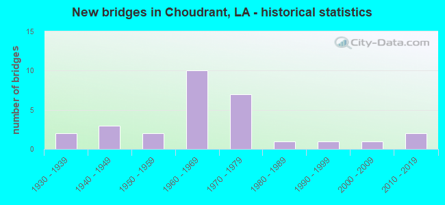
- New bridges - historical statistics
- 21930-1939
- 31940-1949
- 21950-1959
- 101960-1969
- 71970-1979
- 11980-1989
- 11990-1999
- 12000-2009
- 22010-2019

- Reconstructed bridges - Historical Statistics
- 21960-1969
- 01970-1979
- 11980-1989


- Bridge Condition - Deck
- 4.5%Very good
- 13.6%Good
- 50.0%Satisfactory
- 22.7%Fair
- 9.1%Poor

- Bridge Condition - Superstructure
- 4.5%Very good
- 4.5%Good
- 59.1%Satisfactory
- 27.3%Fair
- 4.5%Serious

- Bridge Condition - Substructure
- 9.1%Good
- 40.9%Satisfactory
- 40.9%Fair
- 9.1%Poor

- Bridge Condition - Channel
- 4.0%Very good
- 4.0%Good
- 92.0%Satisfactory

- Bridge Condition - Culverts
- 14.3%Good
- 85.7%Satisfactory
Find on map >> Show street view
Structure Number: 52503180203801, Location: 3.81 MI WEST OF LA 144 (Lat: 32.476531, Lng: -92.481400), Route carried "on" structure: State highway 556, Year Built: 1968, Status: Posted for load, Structure Length: 4.11m (13.48ft), Average Daily Traffic: 300 (year 2016), Truck Traffic: 19%, Average Future Daily Traffic: 510 (year 2036), Design Load: H 15, Features Intersected: DRY CREEK
Minimum Vertical Clearance: 30+ m (98+ ft), Kilometerpoint: 6.067, Lanes on structure: 2, Owner: State Highway Agency, Approaching Roadway Width: 6.7m (22.0ft), Material/Design: Wood or Timber, Design/Construction: Stringer/Multi-beam, Number Of Spans In Main Unit: 7, Length of Maximum Span: 5.8m (19.0ft), Curb-To-Curb Width: 7.3m (24.0ft), Out-to-Out Width: 8.4m (27.6ft)
Condition: Deck: Fair, Superstructure: Fair, Substructure: Poor, Channel: Satisfactory, Operating Rating: 25.4 metric tons, Method Used To Determine Operating Rating: Allowable Stress (AS), Inventory Rating: 18.1 metric tons, Method Used To Determine Inventory Rating: Allowable Stress (AS), Structural Evaluation: Meets minimum limits, Deck Geometry: Somewhat better than minimum adequacy, Waterway Adequacy: Equal to present desirable criteria, Approach Roadway Alignment: Equal to present desirable criteria, Bridge Posting: Required (Relationship of Operating Rating to Maximum Legal Load: 0.1 - 9.9% below), Length Of Structure Improvement: 5.03m (16.50ft), Designated Inspection Frequency: Every 24 months, Underwater Inspection Frequency: Every 60 months, Other Special Inspection Frequency: Every 12 months, Inspection Date: June 2020, Underwater Inspection Date: August 2020, Other Special Inspection Date: June 2021, Bridge Improvement Cost: $429,000, Total Project Cost: $643,000 ( Estimate for 2016), Deck Structure Type: Wood or Timber, Wearing Surface/Protective System: Wearing Surface: Bituminous
Find on map >> Show street view
Structure Number: 52503180203941, Location: 3.94 MI WEST OF LA 144 (Lat: 32.477869, Lng: -92.483300), Route carried "on" structure: State highway 556, Year Built: 1968, Status: Open, Structure Length: 4.69m (15.39ft), Average Daily Traffic: 300 (year 2016), Truck Traffic: 19%, Average Future Daily Traffic: 510 (year 2036), Design Load: H 15, Features Intersected: JACK CREEK
Minimum Vertical Clearance: 30+ m (98+ ft), Kilometerpoint: 6.299, Lanes on structure: 2, Owner: State Highway Agency, Approaching Roadway Width: 6.7m (22.0ft), Material/Design: Wood or Timber, Design/Construction: Stringer/Multi-beam, Number Of Spans In Main Unit: 8, Length of Maximum Span: 5.8m (19.0ft), Curb-To-Curb Width: 7.3m (24.0ft), Out-to-Out Width: 8.3m (27.2ft)
Condition: Deck: Poor, Superstructure: Fair, Substructure: Fair, Channel: Satisfactory, Operating Rating: 29.9 metric tons, Method Used To Determine Operating Rating: Allowable Stress (AS), Inventory Rating: 20.9 metric tons, Method Used To Determine Inventory Rating: Allowable Stress (AS), Structural Evaluation: Somewhat better than minimum adequacy, Deck Geometry: Somewhat better than minimum adequacy, Waterway Adequacy: Better than present minimum criteria, Approach Roadway Alignment: Equal to present desirable criteria, Length Of Structure Improvement: 5.61m (18.41ft), Designated Inspection Frequency: Every 24 months, Other Special Inspection Frequency: Every 12 months, Inspection Date: June 2020, Other Special Inspection Date: June 2021, Bridge Improvement Cost: $478,000, Total Project Cost: $717,000 ( Estimate for 2016), Deck Structure Type: Wood or Timber, Wearing Surface/Protective System: Wearing Surface: Bituminous
Find on map >> Show street view
Structure Number: 52503180204051, Location: 4.05 MI WEST OF LA 144 (Lat: 32.479000, Lng: -92.484900), Route carried "on" structure: State highway 556, Year Built: 1968, Status: Posted for load, Structure Length: 2.38m (7.81ft), Average Daily Traffic: 300 (year 2016), Truck Traffic: 19%, Average Future Daily Traffic: 510 (year 2036), Design Load: H 15, Features Intersected: SO CHOUDRANT CR
Minimum Vertical Clearance: 30+ m (98+ ft), Kilometerpoint: 6.492, Lanes on structure: 2, Owner: State Highway Agency, Approaching Roadway Width: 6.7m (22.0ft), Material/Design: Wood or Timber, Design/Construction: Stringer/Multi-beam, Number Of Spans In Main Unit: 4, Length of Maximum Span: 5.8m (19.0ft), Curb-To-Curb Width: 7.3m (24.0ft), Out-to-Out Width: 8.3m (27.2ft)
Condition: Deck: Fair, Superstructure: Satisfactory, Substructure: Fair, Channel: Satisfactory, Operating Rating: 25.4 metric tons, Method Used To Determine Operating Rating: Allowable Stress (AS), Inventory Rating: 19.0 metric tons, Method Used To Determine Inventory Rating: Allowable Stress (AS), Structural Evaluation: Somewhat better than minimum adequacy, Deck Geometry: Somewhat better than minimum adequacy, Waterway Adequacy: Equal to present desirable criteria, Approach Roadway Alignment: Equal to present desirable criteria, Bridge Posting: Required (Relationship of Operating Rating to Maximum Legal Load: 0.1 - 9.9% below), Designated Inspection Frequency: Every 24 months, Inspection Date: June 2020, Deck Structure Type: Wood or Timber, Wearing Surface/Protective System: Wearing Surface: Bituminous
Find on map >> Show street view
Structure Number: 53100000050068, Location: 0.3 MI. SOUTH OF US 80 (Lat: 32.524119, Lng: -92.479419), Route carried "on" structure: County highway , Year Built: 2012, Status: Open, Structure Length: 0.64m (2.10ft), Average Daily Traffic: 187 (year 1979), Average Future Daily Traffic: 317 (year 2036), Design Load: HS 20, Features Intersected: CHOUDRANT CREEK, Facility Carried by Structure: WALKER RD
Minimum Vertical Clearance: 30+ m (98+ ft), Kilometerpoint: 0.000, Lanes on structure: 2, Owner: County Highway Agency, Approaching Roadway Width: 6.4m (21.0ft), Skew: 31 degrees, Material/Design: Steel, Design/Construction: Culvert, Number Of Spans In Main Unit: 2, Length of Maximum Span: 2.7m (8.9ft)
Condition: Channel: Satisfactory, Culverts: Good, Operating Rating: 70.0 metric tons, Method Used To Determine Operating Rating: Load and Resistance Factor Rating (LRFR) rating reported by rating factor(RF) method using HL-93 loadings, Inventory Rating: 54.1 metric tons, Method Used To Determine Inventory Rating: Load and Resistance Factor Rating (LRFR) rating reported by rating factor(RF) method using HL-93 loadings, Structural Evaluation: Better than present minimum criteria, Waterway Adequacy: Better than present minimum criteria, Approach Roadway Alignment: Equal to present minimum criteria, Designated Inspection Frequency: Every 24 months, Inspection Date: October 2021, Deck Structure Type: Other
Find on map >> Show street view
Structure Number: 53100000050295, Location: 0.06 M N OF LA 821 (Lat: 32.583861, Lng: -92.464089), Route carried "on" structure: State highway 145, Year Built: 2018, Status: Open, Structure Length: 1.83m (6.00ft), Average Daily Traffic: 4,700 (year 2017), Truck Traffic: 10%, Average Future Daily Traffic: 6,200 (year 2038), Design Load: Greater than HL93, Features Intersected: CREEK
Minimum Vertical Clearance: 30+ m (98+ ft), Kilometerpoint: 8.000, Lanes on structure: 2, Owner: State Highway Agency, Approaching Roadway Width: 7.6m (24.9ft), Material/Design: Prestressed concrete, Design/Construction: Slab, Number Of Spans In Main Unit: 3, Length of Maximum Span: 6.1m (20.0ft), Curb-To-Curb Width: 9.9m (32.5ft), Out-to-Out Width: 10.6m (34.8ft)
Condition: Deck: Very good, Superstructure: Very good, Substructure: Satisfactory, Channel: Very good, Operating Rating: 71.3 metric tons, Method Used To Determine Operating Rating: Load and Resistance Factor Rating (LRFR) rating reported by rating factor(RF) method using HL-93 loadings, Inventory Rating: 55.1 metric tons, Method Used To Determine Inventory Rating: Load and Resistance Factor Rating (LRFR) rating reported by rating factor(RF) method using HL-93 loadings, Structural Evaluation: Equal to present minimum criteria, Deck Geometry: Meets minimum limits, Waterway Adequacy: Equal to present desirable criteria, Approach Roadway Alignment: Equal to present desirable criteria, Designated Inspection Frequency: Every 24 months, Inspection Date: November 2021, Deck Structure Type: Concrete Precast Panels
Find on map >> Show street view
Structure Number: 53100010806541, Location: 4.2 MI EAST OF LA 33 (Lat: 32.533519, Lng: -92.538100), Route carried "on" structure: US 80, Year Built: 1952, Status: Open, Structure Length: 0.82m (2.69ft), Average Daily Traffic: 3,200 (year 2016), Truck Traffic: 15%, Average Future Daily Traffic: 5,610 (year 2036), Design Load: H 15, Features Intersected: CREEK
Minimum Vertical Clearance: 30+ m (98+ ft), Kilometerpoint: 10.490, Lanes on structure: 2, Owner: State Highway Agency, Approaching Roadway Width: 12.2m (40.0ft), Material/Design: Concrete, Design/Construction: Culvert, Number Of Spans In Main Unit: 4, Length of Maximum Span: 1.8m (5.9ft), Curb-To-Curb Width: 12.2m (40.0ft), Out-to-Out Width: 13.5m (44.3ft)
Condition: Channel: Satisfactory, Culverts: Satisfactory, Operating Rating: 27.9 metric tons, Method Used To Determine Operating Rating: Load and Resistance Factor Rating (LRFR) rating reported by rating factor(RF) method using HL-93 loadings, Inventory Rating: 21.7 metric tons, Method Used To Determine Inventory Rating: Load and Resistance Factor Rating (LRFR) rating reported by rating factor(RF) method using HL-93 loadings, Structural Evaluation: Somewhat better than minimum adequacy, Deck Geometry: Equal to present minimum criteria, Waterway Adequacy: Better than present minimum criteria, Approach Roadway Alignment: Better than present minimum criteria, Designated Inspection Frequency: Every 24 months, Inspection Date: October 2021, Deck Structure Type: Concrete Cast-file-Place
Find on map >> Show street view
Structure Number: 53100010809211, Location: 1.3 MI EAST OF LA 145 (Lat: 32.528389, Lng: -92.493369), Route carried "on" structure: US 80, Year Built: 1952, Status: Open, Structure Length: 1.04m (3.41ft), Average Daily Traffic: 1,930 (year 2016), Truck Traffic: 15%, Average Future Daily Traffic: 3,264 (year 2036), Design Load: H 15, Features Intersected: CREEK
Minimum Vertical Clearance: 30+ m (98+ ft), Kilometerpoint: 14.801, Lanes on structure: 2, Owner: State Highway Agency, Approaching Roadway Width: 12.2m (40.0ft), Material/Design: Concrete, Design/Construction: Culvert, Number Of Spans In Main Unit: 4, Length of Maximum Span: 2.4m (7.9ft), Curb-To-Curb Width: 7.3m (24.0ft), Out-to-Out Width: 13.4m (44.0ft)
Condition: Channel: Satisfactory, Culverts: Satisfactory, Operating Rating: 29.2 metric tons, Method Used To Determine Operating Rating: Load and Resistance Factor Rating (LRFR) rating reported by rating factor(RF) method using HL-93 loadings, Inventory Rating: 22.4 metric tons, Method Used To Determine Inventory Rating: Load and Resistance Factor Rating (LRFR) rating reported by rating factor(RF) method using HL-93 loadings, Structural Evaluation: Somewhat better than minimum adequacy, Deck Geometry: Meets minimum limits, Waterway Adequacy: Better than present minimum criteria, Approach Roadway Alignment: Better than present minimum criteria, Designated Inspection Frequency: Every 24 months, Inspection Date: October 2021, Deck Structure Type: Concrete Cast-file-Place
Find on map >> Show street view
Structure Number: 53100010811021, Location: 3.1 MI EAST OF LA 145 (Lat: 32.525411, Lng: -92.461600), Route carried "on" structure: US 80, Year Built: 1948, Status: Open, Structure Length: 11.09m (36.38ft), Average Daily Traffic: 1,930 (year 2016), Truck Traffic: 15%, Average Future Daily Traffic: 3,264 (year 2036), Design Load: HS 20, Features Intersected: CREEK
Minimum Vertical Clearance: 30+ m (98+ ft), Kilometerpoint: 17.770, Lanes on structure: 2, Owner: State Highway Agency, Approaching Roadway Width: 12.2m (40.0ft), Material/Design: Concrete, Design/Construction: Tee Beam, Number Of Spans In Main Unit: 14, Length of Maximum Span: 7.9m (25.9ft), Curb-To-Curb Width: 9.1m (29.9ft), Out-to-Out Width: 10.8m (35.4ft)
Condition: Deck: Satisfactory, Superstructure: Satisfactory, Substructure: Satisfactory, Channel: Satisfactory, Operating Rating: 60.8 metric tons, Method Used To Determine Operating Rating: Load Factor (LF), Inventory Rating: 36.3 metric tons, Method Used To Determine Inventory Rating: Load Factor (LF), Structural Evaluation: Equal to present minimum criteria, Deck Geometry: Somewhat better than minimum adequacy, Waterway Adequacy: Better than present minimum criteria, Approach Roadway Alignment: Better than present minimum criteria, Designated Inspection Frequency: Every 24 months, Inspection Date: October 2021, Deck Structure Type: Concrete Cast-file-Place, Wearing Surface/Protective System: Wearing Surface: Bituminous
Find on map >> Show street view
Structure Number: 53100010811711, Location: 3.3 MI EAST OF LA 145 (Lat: 32.521881, Lng: -92.451800), Route carried "on" structure: US 80, Year Built: 1948, Status: Open, Structure Length: 13.47m (44.19ft), Average Daily Traffic: 1,930 (year 2016), Truck Traffic: 15%, Average Future Daily Traffic: 3,264 (year 2036), Design Load: HS 20, Features Intersected: CHOUDRANT CREEK
Minimum Vertical Clearance: 30+ m (98+ ft), Kilometerpoint: 18.768, Lanes on structure: 2, Owner: State Highway Agency, Approaching Roadway Width: 12.2m (40.0ft), Material/Design: Concrete, Design/Construction: Tee Beam, Number Of Spans In Main Unit: 17, Length of Maximum Span: 7.9m (25.9ft), Curb-To-Curb Width: 9.1m (29.9ft), Out-to-Out Width: 10.7m (35.1ft)
Condition: Deck: Satisfactory, Superstructure: Satisfactory, Substructure: Satisfactory, Channel: Satisfactory, Operating Rating: 61.7 metric tons, Method Used To Determine Operating Rating: Load Factor (LF), Inventory Rating: 37.2 metric tons, Method Used To Determine Inventory Rating: Load Factor (LF), Structural Evaluation: Equal to present minimum criteria, Deck Geometry: Somewhat better than minimum adequacy, Waterway Adequacy: Better than present minimum criteria, Approach Roadway Alignment: Better than present minimum criteria, Designated Inspection Frequency: Every 24 months, Inspection Date: October 2021, Deck Structure Type: Concrete Cast-file-Place, Wearing Surface/Protective System: Wearing Surface: Bituminous
Find on map >> Show street view
Structure Number: 53100010812001, Location: 4.1 MI EAST OF LA 145 (Lat: 32.519850, Lng: -92.446200), Route carried "on" structure: US 80, Year Built: 1948, Status: Open, Structure Length: 6.34m (20.80ft), Average Daily Traffic: 1,930 (year 2016), Truck Traffic: 15%, Average Future Daily Traffic: 3,264 (year 2036), Design Load: HS 20, Features Intersected: CREEK
Minimum Vertical Clearance: 30+ m (98+ ft), Kilometerpoint: 19.344, Lanes on structure: 2, Owner: State Highway Agency, Approaching Roadway Width: 11.6m (38.1ft), Material/Design: Concrete, Design/Construction: Tee Beam, Number Of Spans In Main Unit: 8, Length of Maximum Span: 7.9m (25.9ft), Curb-To-Curb Width: 9.1m (29.9ft), Out-to-Out Width: 10.8m (35.4ft)
Condition: Deck: Satisfactory, Superstructure: Satisfactory, Substructure: Satisfactory, Channel: Satisfactory, Operating Rating: 59.9 metric tons, Method Used To Determine Operating Rating: Load Factor (LF), Inventory Rating: 35.4 metric tons, Method Used To Determine Inventory Rating: Load Factor (LF), Structural Evaluation: Equal to present minimum criteria, Deck Geometry: Somewhat better than minimum adequacy, Waterway Adequacy: Better than present minimum criteria, Approach Roadway Alignment: Better than present minimum criteria, Designated Inspection Frequency: Every 24 months, Inspection Date: October 2021, Deck Structure Type: Concrete Cast-file-Place, Wearing Surface/Protective System: Wearing Surface: Bituminous
Find on map >> Show street view
Structure Number: 53100690109301, Location: .5 MI SOUTH OF LA 820 (Lat: 32.627989, Lng: -92.534789), Route carried "on" structure: State highway 33, Year Built: 1937, Year Reconstructed: 1971, Status: Open, Structure Length: 0.79m (2.59ft), Average Daily Traffic: 5,100 (year 2016), Truck Traffic: 16%, Average Future Daily Traffic: 8,670 (year 2036), Design Load: H 15, Features Intersected: CREEK
Minimum Vertical Clearance: 30+ m (98+ ft), Kilometerpoint: 14.904, Lanes on structure: 2, Base Highway Network: Yes (Inventory Route: 69-01-1, Subroute: 10), Owner: State Highway Agency, Approaching Roadway Width: 13.4m (44.0ft), Material/Design: Concrete, Design/Construction: Culvert, Number Of Spans In Main Unit: 3, Length of Maximum Span: 2.4m (7.9ft), Curb-To-Curb Width: 13.4m (44.0ft), Out-to-Out Width: 17.2m (56.4ft)
Condition: Channel: Satisfactory, Culverts: Satisfactory, Operating Rating: 42.1 metric tons, Method Used To Determine Operating Rating: Load and Resistance Factor Rating (LRFR) rating reported by rating factor(RF) method using HL-93 loadings, Inventory Rating: 32.4 metric tons, Method Used To Determine Inventory Rating: Load and Resistance Factor Rating (LRFR) rating reported by rating factor(RF) method using HL-93 loadings, Structural Evaluation: Equal to present minimum criteria, Deck Geometry: Equal to present minimum criteria, Waterway Adequacy: Equal to present minimum criteria, Approach Roadway Alignment: Equal to present minimum criteria, Designated Inspection Frequency: Every 24 months, Inspection Date: November 2021, Deck Structure Type: Concrete Cast-file-Place
Find on map >> Show street view
Structure Number: 53100690110211, Location: .4 MI NORTH OF LA 820 (Lat: 32.634100, Lng: -92.521531), Route carried "on" structure: State highway 33, Year Built: 1938, Year Reconstructed: 1971, Status: Open, Structure Length: 0.79m (2.59ft), Average Daily Traffic: 5,100 (year 2016), Truck Traffic: 16%, Average Future Daily Traffic: 8,670 (year 2036), Design Load: H 15, Features Intersected: BOGGY BRANCH
Minimum Vertical Clearance: 30+ m (98+ ft), Kilometerpoint: 16.415, Lanes on structure: 2, Base Highway Network: Yes (Inventory Route: 69-01-1, Subroute: 10), Owner: State Highway Agency, Approaching Roadway Width: 13.4m (44.0ft), Material/Design: Concrete, Design/Construction: Culvert, Number Of Spans In Main Unit: 3, Length of Maximum Span: 2.4m (7.9ft), Curb-To-Curb Width: 13.4m (44.0ft), Out-to-Out Width: 16.5m (54.1ft)
Condition: Channel: Satisfactory, Culverts: Satisfactory, Operating Rating: 42.1 metric tons, Method Used To Determine Operating Rating: Load and Resistance Factor Rating (LRFR) rating reported by rating factor(RF) method using HL-93 loadings, Inventory Rating: 32.4 metric tons, Method Used To Determine Inventory Rating: Load and Resistance Factor Rating (LRFR) rating reported by rating factor(RF) method using HL-93 loadings, Structural Evaluation: Equal to present minimum criteria, Deck Geometry: Equal to present minimum criteria, Waterway Adequacy: Better than present minimum criteria, Approach Roadway Alignment: Better than present minimum criteria, Designated Inspection Frequency: Every 24 months, Inspection Date: November 2021, Deck Structure Type: Concrete Cast-file-Place
Find on map >> Show street view
Structure Number: 53101570202951, Location: .1 MI NORTH OF LA 556 (Lat: 32.522311, Lng: -92.515300), Route carried "on" structure: State highway 145, Year Built: 1975, Status: Open, Structure Length: 3.51m (11.52ft), Average Daily Traffic: 1,490 (year 2016), Truck Traffic: 15%, Average Future Daily Traffic: 2,533 (year 2036), Design Load: HS 20, Features Intersected: LITTLE CHOUDRANT CREEK
Minimum Vertical Clearance: 30+ m (98+ ft), Kilometerpoint: 4.706, Lanes on structure: 2, Owner: State Highway Agency, Approaching Roadway Width: 11.9m (39.0ft), Material/Design: Concrete, Design/Construction: Slab, Number Of Spans In Main Unit: 6, Length of Maximum Span: 5.8m (19.0ft), Curb-To-Curb Width: 8.5m (27.9ft), Out-to-Out Width: 9.5m (31.2ft)
Condition: Deck: Fair, Superstructure: Fair, Substructure: Fair, Channel: Satisfactory, Operating Rating: 60.8 metric tons, Method Used To Determine Operating Rating: Load Factor (LF), Inventory Rating: 36.3 metric tons, Method Used To Determine Inventory Rating: Load Factor (LF), Structural Evaluation: Somewhat better than minimum adequacy, Deck Geometry: Somewhat better than minimum adequacy, Waterway Adequacy: Somewhat better than minimum adequacy, Approach Roadway Alignment: Equal to present desirable criteria, Designated Inspection Frequency: Every 24 months, Inspection Date: November 2021, Deck Structure Type: Concrete Precast Panels, Wearing Surface/Protective System: Wearing Surface: Bituminous
Find on map >> Show street view
Structure Number: 53101570203041, Location: .2 MI NORTH OF LA 556 (Lat: 32.523600, Lng: -92.515000), Route carried "on" structure: State highway 145, Year Built: 1975, Status: Open, Structure Length: 2.35m (7.71ft), Average Daily Traffic: 1,490 (year 2016), Truck Traffic: 15%, Average Future Daily Traffic: 2,533 (year 2036), Design Load: HS 20, Features Intersected: CHOUDRANT CREEK RELIEF
Minimum Vertical Clearance: 30+ m (98+ ft), Kilometerpoint: 4.851, Lanes on structure: 2, Owner: State Highway Agency, Approaching Roadway Width: 12.2m (40.0ft), Material/Design: Concrete, Design/Construction: Slab, Number Of Spans In Main Unit: 4, Length of Maximum Span: 5.8m (19.0ft), Curb-To-Curb Width: 8.5m (27.9ft), Out-to-Out Width: 9.6m (31.5ft)
Condition: Deck: Satisfactory, Superstructure: Satisfactory, Substructure: Satisfactory, Channel: Satisfactory, Operating Rating: 60.8 metric tons, Method Used To Determine Operating Rating: Load Factor (LF), Inventory Rating: 36.3 metric tons, Method Used To Determine Inventory Rating: Load Factor (LF), Structural Evaluation: Equal to present minimum criteria, Deck Geometry: Somewhat better than minimum adequacy, Waterway Adequacy: Somewhat better than minimum adequacy, Approach Roadway Alignment: Equal to present desirable criteria, Designated Inspection Frequency: Every 24 months, Inspection Date: November 2021, Deck Structure Type: Concrete Precast Panels, Wearing Surface/Protective System: Wearing Surface: Bituminous
Find on map >> Show street view
Structure Number: 53101570203101, Location: .3 MI NORTH OF LA 556 (Lat: 32.524481, Lng: -92.514800), Route carried "on" structure: State highway 145, Year Built: 1975, Status: Open, Structure Length: 4.08m (13.39ft), Average Daily Traffic: 1,490 (year 2016), Truck Traffic: 15%, Average Future Daily Traffic: 2,533 (year 2036), Design Load: HS 20, Features Intersected: CHOUDRANT CREEK RELIEF
Minimum Vertical Clearance: 30+ m (98+ ft), Kilometerpoint: 4.949, Lanes on structure: 2, Owner: State Highway Agency, Approaching Roadway Width: 11.3m (37.1ft), Material/Design: Concrete, Design/Construction: Slab, Number Of Spans In Main Unit: 7, Length of Maximum Span: 5.8m (19.0ft), Curb-To-Curb Width: 8.5m (27.9ft), Out-to-Out Width: 9.6m (31.5ft)
Condition: Deck: Satisfactory, Superstructure: Satisfactory, Substructure: Fair, Channel: Satisfactory, Operating Rating: 62.6 metric tons, Method Used To Determine Operating Rating: Load Factor (LF), Inventory Rating: 37.2 metric tons, Method Used To Determine Inventory Rating: Load Factor (LF), Structural Evaluation: Somewhat better than minimum adequacy, Deck Geometry: Somewhat better than minimum adequacy, Waterway Adequacy: Meets minimum limits, Approach Roadway Alignment: Equal to present desirable criteria, Designated Inspection Frequency: Every 24 months, Inspection Date: November 2021, Deck Structure Type: Concrete Precast Panels, Wearing Surface/Protective System: Wearing Surface: Bituminous
Find on map >> Show street view
Structure Number: 53101570300591, Location: LA 145 OVER I-20 (Lat: 32.537581, Lng: -92.510300), Route carried "on" structure: State highway 145, Year Built: 2008, Status: Open, Structure Length: 10.42m (34.19ft), Average Daily Traffic: 4,200 (year 2016), Truck Traffic: 15%, Average Future Daily Traffic: 7,140 (year 2036), Design Load: HS 20, Features Intersected: I-20
Minimum Vertical Clearance: 30+ m (98+ ft), Kilometerpoint: 0.951, Lanes on structure: 2, Lanes under structure: 4, Owner: State Highway Agency, Approaching Roadway Width: 8.5m (27.9ft), Skew: 37 degrees, Material/Design: Steel, Design/Construction: Stringer/Multi-beam, Number Of Spans In Main Unit: 6, Length of Maximum Span: 22.9m (75.1ft), Curb-To-Curb Width: 20.7m (67.9ft), Out-to-Out Width: 21.6m (70.9ft)
Condition: Deck: Good, Superstructure: Satisfactory, Substructure: Satisfactory, Operating Rating: 52.6 metric tons, Method Used To Determine Operating Rating: Load Factor (LF), Inventory Rating: 31.7 metric tons, Method Used To Determine Inventory Rating: Load Factor (LF), Structural Evaluation: Equal to present minimum criteria, Deck Geometry: Superior to present desirable criteria, Underclear: Better than present minimum criteria, Approach Roadway Alignment: Better than present minimum criteria, Designated Inspection Frequency: Every 24 months, Inspection Date: November 2021, Deck Structure Type: Concrete Cast-file-Place, Wearing Surface/Protective System: Wearing Surface: Wood or Timber
Find on map >> Show street view
Structure Number: 53101570300781, Location: .19 MI NORTH OF I-20 (Lat: 32.539950, Lng: -92.508700), Route carried "on" structure: State highway 145, Year Built: 1960, Status: Open, Structure Length: 0.91m (2.99ft), Average Daily Traffic: 4,200 (year 2016), Truck Traffic: 15%, Average Future Daily Traffic: 7,140 (year 2036), Design Load: HS 20, Features Intersected: CREEK
Minimum Vertical Clearance: 30+ m (98+ ft), Kilometerpoint: 1.254, Lanes on structure: 2, Owner: State Highway Agency, Approaching Roadway Width: 11.0m (36.1ft), Material/Design: Concrete, Design/Construction: Culvert, Number Of Spans In Main Unit: 3, Length of Maximum Span: 2.7m (8.9ft)
Condition: Channel: Satisfactory, Culverts: Satisfactory, Operating Rating: 42.1 metric tons, Method Used To Determine Operating Rating: Load and Resistance Factor Rating (LRFR) rating reported by rating factor(RF) method using HL-93 loadings, Inventory Rating: 32.4 metric tons, Method Used To Determine Inventory Rating: Load and Resistance Factor Rating (LRFR) rating reported by rating factor(RF) method using HL-93 loadings, Structural Evaluation: Equal to present minimum criteria, Waterway Adequacy: Equal to present minimum criteria, Approach Roadway Alignment: Equal to present minimum criteria, Designated Inspection Frequency: Every 24 months, Inspection Date: November 2021, Deck Structure Type: Concrete Cast-file-Place
Find on map >> Show street view
Structure Number: 53101570302491, Location: 2.49 MI N of US 80 (Lat: 32.558250, Lng: -92.489600), Route carried "on" structure: State highway 145, Year Built: 1982, Status: Open, Structure Length: 1.74m (5.71ft), Average Daily Traffic: 4,200 (year 2016), Truck Traffic: 15%, Average Future Daily Traffic: 7,140 (year 2036), Design Load: HS 20, Features Intersected: SQUIRES CREEK
Minimum Vertical Clearance: 30+ m (98+ ft), Kilometerpoint: 3.965, Lanes on structure: 2, Owner: State Highway Agency, Approaching Roadway Width: 12.2m (40.0ft), Material/Design: Concrete, Design/Construction: Slab, Number Of Spans In Main Unit: 3, Length of Maximum Span: 5.8m (19.0ft), Curb-To-Curb Width: 9.8m (32.2ft), Out-to-Out Width: 10.5m (34.4ft)
Condition: Deck: Satisfactory, Superstructure: Satisfactory, Substructure: Fair, Channel: Satisfactory, Operating Rating: 31.1 metric tons, Method Used To Determine Operating Rating: Load and Resistance Factor Rating (LRFR) rating reported by rating factor(RF) method using HL-93 loadings, Inventory Rating: 24.0 metric tons, Method Used To Determine Inventory Rating: Load and Resistance Factor Rating (LRFR) rating reported by rating factor(RF) method using HL-93 loadings, Structural Evaluation: Somewhat better than minimum adequacy, Deck Geometry: Meets minimum limits, Waterway Adequacy: Better than present minimum criteria, Approach Roadway Alignment: Equal to present minimum criteria, Designated Inspection Frequency: Every 24 months, Inspection Date: November 2021, Deck Structure Type: Concrete Precast Panels, Wearing Surface/Protective System: Wearing Surface: Bituminous
Find on map >> Show street view
Structure Number: 53103180301521, Location: .29 MI SOUTH OF LA 145 (Lat: 32.517581, Lng: -92.514000), Route carried "on" structure: State highway 556, Year Built: 1974, Status: Open, Structure Length: 1.83m (6.00ft), Average Daily Traffic: 300 (year 2016), Truck Traffic: 19%, Average Future Daily Traffic: 510 (year 2036), Design Load: HS 20, Features Intersected: LITTLE CHOUDRANT
Minimum Vertical Clearance: 30+ m (98+ ft), Kilometerpoint: 2.483, Lanes on structure: 2, Owner: State Highway Agency, Approaching Roadway Width: 6.7m (22.0ft), Material/Design: Concrete, Design/Construction: Slab, Number Of Spans In Main Unit: 3, Length of Maximum Span: 6.1m (20.0ft), Curb-To-Curb Width: 8.5m (27.9ft), Out-to-Out Width: 9.5m (31.2ft)
Condition: Deck: Satisfactory, Superstructure: Satisfactory, Substructure: Fair, Channel: Satisfactory, Operating Rating: 65.3 metric tons, Method Used To Determine Operating Rating: Load Factor (LF), Inventory Rating: 39.0 metric tons, Method Used To Determine Inventory Rating: Load Factor (LF), Structural Evaluation: Somewhat better than minimum adequacy, Deck Geometry: Equal to present minimum criteria, Waterway Adequacy: Equal to present desirable criteria, Approach Roadway Alignment: Equal to present desirable criteria, Designated Inspection Frequency: Every 24 months, Inspection Date: November 2021, Deck Structure Type: Concrete Precast Panels, Wearing Surface/Protective System: Wearing Surface: Monolithic Concrete
Find on map >> Show street view
Structure Number: 53103180406141, Location: .63 MI SOUTH OF LA 33 (Lat: 32.621411, Lng: -92.526900), Route carried "on" structure: State highway 820, Year Built: 1979, Status: Open, Structure Length: 2.93m (9.61ft), Average Daily Traffic: 1,640 (year 2016), Truck Traffic: 19%, Average Future Daily Traffic: 2,754 (year 2036), Design Load: HS 20, Features Intersected: STOWE CREEK
Minimum Vertical Clearance: 30+ m (98+ ft), Kilometerpoint: 9.830, Lanes on structure: 2, Owner: State Highway Agency, Approaching Roadway Width: 11.6m (38.1ft), Material/Design: Concrete, Design/Construction: Slab, Number Of Spans In Main Unit: 5, Length of Maximum Span: 5.8m (19.0ft), Curb-To-Curb Width: 9.8m (32.2ft), Out-to-Out Width: 10.7m (35.1ft)
Condition: Deck: Fair, Superstructure: Fair, Substructure: Poor, Channel: Satisfactory, Operating Rating: 34.0 metric tons, Method Used To Determine Operating Rating: Load and Resistance Factor Rating (LRFR) rating reported by rating factor(RF) method using HL-93 loadings, Inventory Rating: 26.2 metric tons, Method Used To Determine Inventory Rating: Load and Resistance Factor Rating (LRFR) rating reported by rating factor(RF) method using HL-93 loadings, Structural Evaluation: Meets minimum limits, Deck Geometry: Somewhat better than minimum adequacy, Waterway Adequacy: Equal to present desirable criteria, Approach Roadway Alignment: Equal to present minimum criteria, Length Of Structure Improvement: 3.75m (12.30ft), Designated Inspection Frequency: Every 24 months, Other Special Inspection Frequency: Every 12 months, Inspection Date: November 2021, Other Special Inspection Date: December 2020, Bridge Improvement Cost: $319,000, Roadway Improvement Cost: $31,000, Total Project Cost: $478,000 ( Estimate for 2016), Deck Structure Type: Concrete Precast Panels, Wearing Surface/Protective System: Wearing Surface: Monolithic Concrete
Find on map >> Show street view
Structure Number: 53103180406231, Location: .54 MI SOUTH OF LA 33 (Lat: 32.621411, Lng: -92.526900), Route carried "on" structure: State highway 820, Year Built: 1979, Status: Open, Structure Length: 2.93m (9.61ft), Average Daily Traffic: 1,640 (year 2016), Truck Traffic: 19%, Average Future Daily Traffic: 2,754 (year 2036), Design Load: HS 20, Features Intersected: CREEK
Minimum Vertical Clearance: 30+ m (98+ ft), Kilometerpoint: 9.830, Lanes on structure: 2, Owner: State Highway Agency, Approaching Roadway Width: 11.6m (38.1ft), Material/Design: Concrete, Design/Construction: Slab, Number Of Spans In Main Unit: 5, Length of Maximum Span: 5.8m (19.0ft), Curb-To-Curb Width: 9.8m (32.2ft), Out-to-Out Width: 10.7m (35.1ft)
Condition: Deck: Satisfactory, Superstructure: Satisfactory, Substructure: Fair, Channel: Satisfactory, Operating Rating: 65.3 metric tons, Method Used To Determine Operating Rating: Load Factor (LF), Inventory Rating: 39.0 metric tons, Method Used To Determine Inventory Rating: Load Factor (LF), Structural Evaluation: Somewhat better than minimum adequacy, Deck Geometry: Somewhat better than minimum adequacy, Waterway Adequacy: Equal to present desirable criteria, Approach Roadway Alignment: Equal to present minimum criteria, Designated Inspection Frequency: Every 24 months, Inspection Date: November 2021, Deck Structure Type: Concrete Precast Panels, Wearing Surface/Protective System: Wearing Surface: Monolithic Concrete
Find on map >> Show street view
Structure Number: 53104510519981, Location: 4.35 MI EAST OF LA 33 (Lat: 32.539539, Lng: -92.540819), Route carried "on" structure: Interstate 20, Year Built: 1960, Status: Open, Structure Length: 0.82m (2.69ft), Average Daily Traffic: 36,400 (year 2016), Truck Traffic: 37%, Average Future Daily Traffic: 61,200 (year 2036), Design Load: HS 20, Features Intersected: CREEK
Minimum Vertical Clearance: 30+ m (98+ ft), Kilometerpoint: 31.979, Lanes on structure: 4, Base Highway Network: Yes (Inventory Route: 451-05-1, Subroute: 10), Owner: State Highway Agency, Approaching Roadway Width: 12.8m (42.0ft), Skew: 10 degrees, Material/Design: Concrete, Design/Construction: Culvert, Number Of Spans In Main Unit: 3, Length of Maximum Span: 2.4m (7.9ft), Curb-To-Curb Width: 25.6m (84.0ft), Out-to-Out Width: 55.2m (181.1ft)
Condition: Channel: Satisfactory, Culverts: Satisfactory, Operating Rating: 64.8 metric tons, Method Used To Determine Operating Rating: Load and Resistance Factor Rating (LRFR) rating reported by rating factor(RF) method using HL-93 loadings, Inventory Rating: 50.5 metric tons, Method Used To Determine Inventory Rating: Load and Resistance Factor Rating (LRFR) rating reported by rating factor(RF) method using HL-93 loadings, Structural Evaluation: Equal to present minimum criteria, Deck Geometry: Superior to present desirable criteria, Waterway Adequacy: Better than present minimum criteria, Approach Roadway Alignment: Better than present minimum criteria, Designated Inspection Frequency: Every 24 months, Inspection Date: December 2021, Deck Structure Type: Concrete Cast-file-Place
Find on map >> Show street view
Structure Number: 53104510520991, Location: 5.35 MI EAST OF LA 33 (Lat: 32.539081, Lng: -92.523600), Route carried "on" structure: County highway , Year Built: 1960, Status: Posted for load, Structure Length: 9.05m (29.69ft), Average Daily Traffic: 3,600 (year 2015), Average Future Daily Traffic: 6,120 (year 2036), Design Load: HS 20, Features Intersected: I 20, Facility Carried by Structure: PIPES RD
Minimum Vertical Clearance: 30+ m (98+ ft), Kilometerpoint: 33.634, Lanes on structure: 2, Lanes under structure: 4, Base Highway Network: Yes (Inventory Route: 451-05-1, Subroute: 10), Owner: State Highway Agency, Approaching Roadway Width: 9.1m (29.9ft), Skew: 1 degrees, Material/Design: Steel, Design/Construction: Stringer/Multi-beam, Number Of Spans In Main Unit: 6, Length of Maximum Span: 21.3m (69.9ft), Curb-To-Curb Width: 7.3m (24.0ft), Out-to-Out Width: 9.0m (29.5ft)
Condition: Deck: Satisfactory, Superstructure: Fair, Substructure: Satisfactory, Operating Rating: 38.1 metric tons, Method Used To Determine Operating Rating: Load Factor (LF), Inventory Rating: 22.7 metric tons, Method Used To Determine Inventory Rating: Load Factor (LF), Structural Evaluation: Somewhat better than minimum adequacy, Deck Geometry: High priority of replacement, Underclear: High priority of replacement, Approach Roadway Alignment: Equal to present desirable criteria, Bridge Posting: Required (Relationship of Operating Rating to Maximum Legal Load: 0.1 - 9.9% below), Length Of Structure Improvement: 9.97m (32.71ft), Designated Inspection Frequency: Every 24 months, Inspection Date: December 2021, Bridge Improvement Cost: $850,000, Roadway Improvement Cost: $85,000, Total Project Cost: $1,275,000 ( Estimate for 2016), Deck Structure Type: Concrete Cast-file-Place, Wearing Surface/Protective System: Wearing Surface: Monolithic Concrete
Find on map >> Show street view
Structure Number: 53104510522461, Location: .8 MI EAST OF LA 145M (Lat: 32.536131, Lng: -92.498600), Route carried "on" structure: Interstate 20, Year Built: 1960, Status: Open, Structure Length: 4.88m (16.01ft), Average Daily Traffic: 17,800 (year 2016), Truck Traffic: 37%, Average Future Daily Traffic: 36,924 (year 2036), Design Load: HS 20, Features Intersected: N.FORK CHOUDRANT E-BOUND
Minimum Vertical Clearance: 30+ m (98+ ft), Kilometerpoint: 36.014, Lanes on structure: 2, Base Highway Network: Yes (Inventory Route: 451-05-1, Subroute: 10), Owner: State Highway Agency, Approaching Roadway Width: 12.8m (42.0ft), Skew: 10 degrees, Material/Design: Concrete, Design/Construction: Slab, Number Of Spans In Main Unit: 8, Length of Maximum Span: 6.1m (20.0ft), Curb-To-Curb Width: 8.5m (27.9ft), Out-to-Out Width: 10.2m (33.5ft)
Condition: Deck: Satisfactory, Superstructure: Satisfactory, Substructure: Satisfactory, Channel: Satisfactory, Operating Rating: 72.6 metric tons, Method Used To Determine Operating Rating: Load Factor (LF), Inventory Rating: 43.5 metric tons, Method Used To Determine Inventory Rating: Load Factor (LF), Structural Evaluation: Equal to present minimum criteria, Deck Geometry: High priority of replacement, Waterway Adequacy: Better than present minimum criteria, Approach Roadway Alignment: Better than present minimum criteria, Length Of Structure Improvement: 5.79m (19.00ft), Designated Inspection Frequency: Every 24 months, Inspection Date: December 2021, Bridge Improvement Cost: $494,000, Roadway Improvement Cost: $49,000, Total Project Cost: $741,000 ( Estimate for 2016), Deck Structure Type: Concrete Cast-file-Place, Wearing Surface/Protective System: Wearing Surface: Monolithic Concrete
Find on map >> Show street view
Structure Number: 53104510522462, Location: .8 MI EAST OF LA 145M (Lat: 32.536289, Lng: -92.498100), Route carried "on" structure: Interstate 20, Year Built: 1960, Status: Open, Structure Length: 4.88m (16.01ft), Average Daily Traffic: 17,800 (year 2016), Truck Traffic: 37%, Average Future Daily Traffic: 36,924 (year 2036), Design Load: HS 20, Features Intersected: N.FORK CHOUDRANT W-BOUND
Minimum Vertical Clearance: 30+ m (98+ ft), Kilometerpoint: 7.934, Lanes on structure: 2, Base Highway Network: Yes (Inventory Route: 451-05-2, Subroute: 10), Owner: State Highway Agency, Approaching Roadway Width: 12.8m (42.0ft), Skew: 10 degrees, Material/Design: Concrete, Design/Construction: Slab, Number Of Spans In Main Unit: 8, Length of Maximum Span: 6.1m (20.0ft), Curb-To-Curb Width: 8.5m (27.9ft), Out-to-Out Width: 10.2m (33.5ft)
Condition: Deck: Fair, Superstructure: Fair, Substructure: Satisfactory, Channel: Satisfactory, Operating Rating: 72.6 metric tons, Method Used To Determine Operating Rating: Load Factor (LF), Inventory Rating: 43.5 metric tons, Method Used To Determine Inventory Rating: Load Factor (LF), Structural Evaluation: Somewhat better than minimum adequacy, Deck Geometry: High priority of replacement, Waterway Adequacy: Equal to present minimum criteria, Approach Roadway Alignment: Equal to present minimum criteria, Length Of Structure Improvement: 5.79m (19.00ft), Designated Inspection Frequency: Every 24 months, Inspection Date: December 2021, Bridge Improvement Cost: $494,000, Roadway Improvement Cost: $49,000, Total Project Cost: $741,000 ( Estimate for 2016), Deck Structure Type: Concrete Cast-file-Place, Wearing Surface/Protective System: Wearing Surface: Monolithic Concrete
Find on map >> Show street view
Structure Number: 53104510523201, Location: 1.6 MI EAST OF LA 145M (Lat: 32.533931, Lng: -92.486400), Route carried "on" structure: County highway , Year Built: 1960, Status: Posted for load, Structure Length: 9.21m (30.22ft), Average Daily Traffic: 3,620 (year 2015), Average Future Daily Traffic: 6,154 (year 2036), Design Load: HS 20, Features Intersected: I-20, Facility Carried by Structure: HARRIS RD
Minimum Vertical Clearance: 30+ m (98+ ft), Kilometerpoint: 37.194, Lanes on structure: 2, Lanes under structure: 4, Base Highway Network: Yes (Inventory Route: 451-05-1, Subroute: 10), Owner: State Highway Agency, Approaching Roadway Width: 9.1m (29.9ft), Skew: 1 degrees, Material/Design: Steel, Design/Construction: Stringer/Multi-beam, Number Of Spans In Main Unit: 6, Length of Maximum Span: 22.9m (75.1ft), Curb-To-Curb Width: 7.3m (24.0ft), Out-to-Out Width: 9.0m (29.5ft)
Condition: Deck: Poor, Superstructure: Serious, Substructure: Fair, Operating Rating: 15.6 metric tons, Method Used To Determine Operating Rating: Load and Resistance Factor Rating (LRFR) rating reported by rating factor(RF) method using HL-93 loadings, Inventory Rating: 12.0 metric tons, Method Used To Determine Inventory Rating: Load and Resistance Factor Rating (LRFR) rating reported by rating factor(RF) method using HL-93 loadings, Structural Evaluation: High priority of replacement, Deck Geometry: High priority of replacement, Underclear: High priority of replacement, Approach Roadway Alignment: Better than present minimum criteria, Bridge Posting: Required (Relationship of Operating Rating to Maximum Legal Load: 30.0 - 39.9% below), Length Of Structure Improvement: 10.12m (33.20ft), Designated Inspection Frequency: Every 24 months, Other Special Inspection Frequency: Every 12 months, Inspection Date: December 2021, Other Special Inspection Date: December 2020, Bridge Improvement Cost: $863,000, Roadway Improvement Cost: $86,000, Total Project Cost: $1,294,000 ( Estimate for 2016), Deck Structure Type: Concrete Cast-file-Place, Wearing Surface/Protective System: Wearing Surface: Monolithic Concrete
Find on map >> Show street view
Structure Number: 53104510525101, Location: 3.5 MI EAST OF LA 145M (Lat: 32.529969, Lng: -92.454100), Route carried "on" structure: County highway , Year Built: 1960, Year Reconstructed: 1993, Status: Open, Structure Length: 12.25m (40.19ft), Average Daily Traffic: 3,620 (year 2015), Average Future Daily Traffic: 6,154 (year 2036), Design Load: HS 20, Features Intersected: I 20, Facility Carried by Structure: NORRIS RD
Minimum Vertical Clearance: 30+ m (98+ ft), Kilometerpoint: 40.246, Lanes on structure: 2, Lanes under structure: 4, Base Highway Network: Yes (Inventory Route: 451-05-1, Subroute: 10), Owner: State Highway Agency, Approaching Roadway Width: 9.1m (29.9ft), Material/Design: Steel, Design/Construction: Stringer/Multi-beam, Number Of Spans In Main Unit: 8, Length of Maximum Span: 21.3m (69.9ft), Curb-To-Curb Width: 7.3m (24.0ft), Out-to-Out Width: 9.0m (29.5ft)
Condition: Deck: Good, Superstructure: Satisfactory, Substructure: Good, Operating Rating: 76.2 metric tons, Method Used To Determine Operating Rating: Load Factor (LF), Inventory Rating: 45.4 metric tons, Method Used To Determine Inventory Rating: Load Factor (LF), Structural Evaluation: Equal to present minimum criteria, Deck Geometry: High priority of replacement, Underclear: High priority of replacement, Approach Roadway Alignment: Equal to present desirable criteria, Length Of Structure Improvement: 13.17m (43.21ft), Designated Inspection Frequency: Every 24 months, Inspection Date: December 2021, Bridge Improvement Cost: $1,123,000, Roadway Improvement Cost: $112,000, Total Project Cost: $1,684,000 ( Estimate for 2016), Deck Structure Type: Concrete Cast-file-Place, Wearing Surface/Protective System: Wearing Surface: Monolithic Concrete
Find on map >> Show street view
Structure Number: 53132315922731, Location: 0.1 MI N of US 80 (Lat: 32.525389, Lng: -92.454850), Route carried "on" structure: County highway , Year Built: 1999, Status: Open, Structure Length: 2.90m (9.51ft), Average Daily Traffic: 73 (year 1979), Average Future Daily Traffic: 124 (year 2036), Design Load: HS 20, Features Intersected: CHOUDRANT CREEK, Facility Carried by Structure: NORRIS RD
Minimum Vertical Clearance: 30+ m (98+ ft), Kilometerpoint: 0.000, Lanes on structure: 2, Base Highway Network: Yes, Owner: County Highway Agency, Approaching Roadway Width: 8.2m (26.9ft), Material/Design: Concrete, Design/Construction: Slab, Number Of Spans In Main Unit: 5, Length of Maximum Span: 5.8m (19.0ft), Curb-To-Curb Width: 8.5m (27.9ft), Out-to-Out Width: 9.3m (30.5ft)
Condition: Deck: Good, Superstructure: Good, Substructure: Good, Channel: Good, Operating Rating: 36.9 metric tons, Method Used To Determine Operating Rating: Load and Resistance Factor Rating (LRFR) rating reported by rating factor(RF) method using HL-93 loadings, Inventory Rating: 28.5 metric tons, Method Used To Determine Inventory Rating: Load and Resistance Factor Rating (LRFR) rating reported by rating factor(RF) method using HL-93 loadings, Structural Evaluation: Better than present minimum criteria, Deck Geometry: Better than present minimum criteria, Waterway Adequacy: Better than present minimum criteria, Approach Roadway Alignment: Equal to present desirable criteria, Designated Inspection Frequency: Every 24 months, Inspection Date: October 2021, Deck Structure Type: Concrete Cast-file-Place
Find on map >> Show street view
Structure Number: 53132318923251, Location: 2 MI NW CHOUDRANT (Lat: 32.530589, Lng: -92.542450), Route carried "on" structure: County highway , Year Built: 1978, Status: Open, Structure Length: 1.77m (5.81ft), Average Daily Traffic: 20 (year 1979), Average Future Daily Traffic: 34 (year 2036), Design Load: H 20, Features Intersected: CHOUDRANT CREEK, Facility Carried by Structure: HOGAN RD
Minimum Vertical Clearance: 30+ m (98+ ft), Kilometerpoint: 0.000, Lanes on structure: 2, Owner: County Highway Agency, Approaching Roadway Width: 7.9m (25.9ft), Material/Design: Wood or Timber, Design/Construction: Stringer/Multi-beam, Number Of Spans In Main Unit: 3, Length of Maximum Span: 5.8m (19.0ft), Curb-To-Curb Width: 6.9m (22.6ft), Out-to-Out Width: 7.3m (24.0ft)
Condition: Deck: Satisfactory, Superstructure: Satisfactory, Substructure: Fair, Channel: Satisfactory, Operating Rating: 27.2 metric tons, Method Used To Determine Operating Rating: Allowable Stress (AS), Inventory Rating: 19.0 metric tons, Method Used To Determine Inventory Rating: Allowable Stress (AS), Structural Evaluation: Somewhat better than minimum adequacy, Deck Geometry: Somewhat better than minimum adequacy, Waterway Adequacy: Better than present minimum criteria, Approach Roadway Alignment: Equal to present desirable criteria, Designated Inspection Frequency: Every 24 months, Inspection Date: October 2021, Deck Structure Type: Wood or Timber, Wearing Surface/Protective System: Wearing Surface: Bituminous
Find on map >> Show street view
Structure Number: 53101570300591, Location: 6.26 MI E OF LA 33 (Lat: 32.538100, Lng: -92.509900), Route carried "under" structure: Interstate 20, Structure Length: 0. m, Average Daily Traffic: 4,200 (year 2015), Features Intersected: LA 145 OVER I-20
Minimum Vertical Clearance: 4.91m (16.11ft), Kilometerpoint: 8.808, Lanes on structure: 2, Length of Maximum Span: 0.0m
Find on map >> Show street view
Structure Number: 53101570300591, Location: 6.26 MI E OF LA 33 (Lat: 32.538219, Lng: -92.509819), Route carried "under" structure: Interstate 20, Structure Length: 0. m, Average Daily Traffic: 4,200 (year 2015), Features Intersected: 145 OVER I-20 WB ON RAMP
Minimum Vertical Clearance: 5.15m (16.90ft), Kilometerpoint: 0.409, Lanes on structure: 2, Length of Maximum Span: 0.0m
Find on map >> Show street view
Structure Number: 53101570300591, Location: 6.26 MI E OF LA 33 (Lat: 32.537911, Lng: -92.510181), Route carried "under" structure: Interstate 20, Structure Length: 0. m, Average Daily Traffic: 4,200 (year 2015), Features Intersected: LA 145 OVER I-20
Minimum Vertical Clearance: 5.21m (17.09ft), Kilometerpoint: 34.920, Lanes on structure: 2, Length of Maximum Span: 0.0m
Find on map >> Show street view
Structure Number: 53104510520991, Location: 0.77 MI W OF LA 145 (Lat: 32.539350, Lng: -92.523639), Route carried "under" structure: Interstate 20, Structure Length: 0. m, Average Daily Traffic: 3,600 (year 2015), Features Intersected: PIPES RD OVER I-20
Minimum Vertical Clearance: 5.03m (16.50ft), Kilometerpoint: 33.635, Lanes on structure: 2, Length of Maximum Span: 0.0m
Find on map >> Show street view
Structure Number: 53104510520991, Location: 0.77 MI W OF LA 145 (Lat: 32.539581, Lng: -92.523500), Route carried "under" structure: Interstate 20, Structure Length: 0. m, Average Daily Traffic: 3,600 (year 2015), Features Intersected: PIPES RD OVER I-20
Minimum Vertical Clearance: 5.15m (16.90ft), Kilometerpoint: 10.355, Lanes on structure: 2, Length of Maximum Span: 0.0m
Find on map >> Show street view
Structure Number: 53104510523201, Location: 1.4 MI E OF LA 145 (Lat: 32.534211, Lng: -92.486231), Route carried "under" structure: Interstate 20, Structure Length: 0. m, Average Daily Traffic: 3,620 (year 2015), Features Intersected: HARRIS RD OVER I-20
Minimum Vertical Clearance: 4.88m (16.01ft), Kilometerpoint: 37.198, Lanes on structure: 2, Length of Maximum Span: 0.0m
Find on map >> Show street view
Structure Number: 53104510523201, Location: 1.4 MI E OF LA 145 (Lat: 32.534431, Lng: -92.486000), Route carried "under" structure: Interstate 20, Structure Length: 0. m, Average Daily Traffic: 3,620 (year 2015), Features Intersected: HARRIS RD OVER I-20
Minimum Vertical Clearance: 5.12m (16.80ft), Kilometerpoint: 6.783, Lanes on structure: 2, Length of Maximum Span: 0.0m
Find on map >> Show street view
Structure Number: 53104510525101, Location: 2.2 MI W OF PARISH LINE (Lat: 32.529411, Lng: -92.454250), Route carried "under" structure: Interstate 20, Structure Length: 0. m, Average Daily Traffic: 3,620 (year 2015), Features Intersected: NORRIS RD OVER I-20
Minimum Vertical Clearance: 5.00m (16.40ft), Kilometerpoint: 40.248, Lanes on structure: 2, Length of Maximum Span: 0.0m
Find on map >> Show street view
Structure Number: 53104510525101, Location: 2.2 MI W OF PARISH LINE (Lat: 32.529661, Lng: -92.454111), Route carried "under" structure: Interstate 20, Structure Length: 0. m, Average Daily Traffic: 3,620 (year 2015), Features Intersected: NORRIS RD OVER I-20
Minimum Vertical Clearance: 5.18m (16.99ft), Kilometerpoint: 3.743, Lanes on structure: 2, Length of Maximum Span: 0.0m