Bridge Statistics for Chugwater, Wyoming (WY)
Condition, Traffic, Stress, Structural Evaluation, Project Costs
- National Bridge Inventory (NBI) Statistics
- 24Number of bridges
- 322ft / 98.5mTotal length
- $1,270,000Total costs
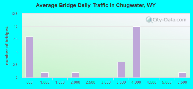
- 55,995Total average daily traffic
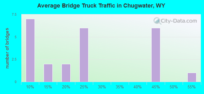
- 15,438Total average daily truck traffic
- National Bridge Inventory (NBI) Registered Bridges for Chugwater
- No street view available for this location
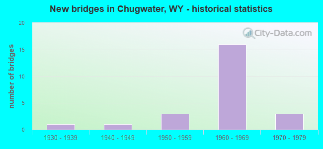
- New bridges - historical statistics
- 11930-1939
- 11940-1949
- 31950-1959
- 161960-1969
- 31970-1979
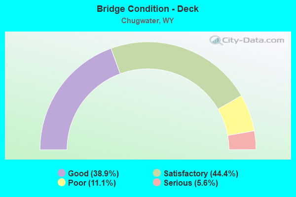
- Bridge Condition - Deck
- 38.9%Good
- 44.4%Satisfactory
- 11.1%Poor
- 5.6%Serious
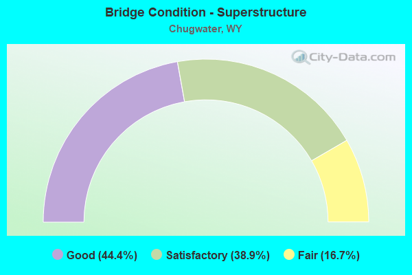
- Bridge Condition - Superstructure
- 44.4%Good
- 38.9%Satisfactory
- 16.7%Fair
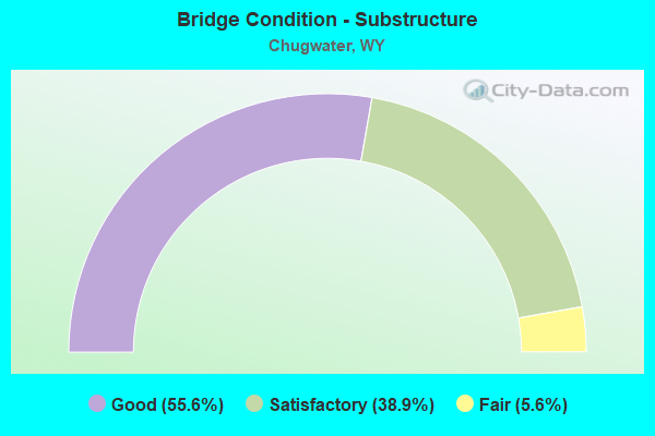
- Bridge Condition - Substructure
- 55.6%Good
- 38.9%Satisfactory
- 5.6%Fair
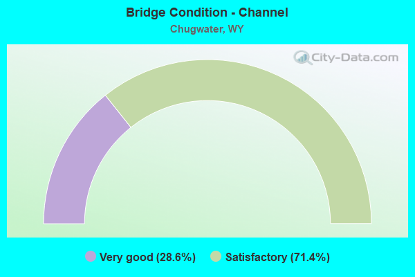
- Bridge Condition - Channel
- 28.6%Very good
- 71.4%Satisfactory
Find on map >> Show street view
Structure Number: ABQ, Location: Us 85 Jct - Wheatland (Lat: 41.232581, Lng: -104.837644), Route carried "on" structure: Interstate 25, Year Built: 1957, Status: Open, Structure Length: 7.36m (24.15ft), Average Daily Traffic: 5,108 (year 2021), Truck Traffic: 18%, Average Future Daily Traffic: 7,151 (year 2041), Design Load: HS 20, Features Intersected: US 85
Minimum Vertical Clearance: 30+ m (98+ ft), Kilometerpoint: 27.679, Lanes on structure: 2, Lanes under structure: 1, Base Highway Network: Yes, Owner: State Highway Agency, Approaching Roadway Width: 9.8m (32.2ft), Skew: 4 degrees, Material/Design: Concrete continuous, Design/Construction: Tee Beam, Number Of Spans In Main Unit: 3, Length of Maximum Span: 27.4m (89.9ft), Curb-To-Curb Width: 9.8m (32.2ft), Out-to-Out Width: 10.7m (35.1ft)
Condition: Deck: Poor, Superstructure: Fair, Substructure: Satisfactory, Operating Rating: 57.2 metric tons, Method Used To Determine Operating Rating: Load Factor (LF), Inventory Rating: 33.6 metric tons, Method Used To Determine Inventory Rating: Load Factor (LF), Structural Evaluation: Somewhat better than minimum adequacy, Deck Geometry: Meets minimum limits, Underclear: High priority of corrective action, Approach Roadway Alignment: Equal to present desirable criteria, Designated Inspection Frequency: Every 24 months, Inspection Date: March 2020, Deck Structure Type: Concrete Cast-file-Place
Find on map >> Show street view
Structure Number: ABS, Location: Us 85 Jct - Wheatland (Lat: 41.261631, Lng: -104.841533), Route carried "on" structure: Interstate 25, Year Built: 1970, Status: Open, Structure Length: 4.08m (13.39ft), Average Daily Traffic: 3,624 (year 2021), Truck Traffic: 19%, Average Future Daily Traffic: 5,074 (year 2041), Design Load: HS 20+Mod, Features Intersected: La CR 218-2 / Farris Rd
Minimum Vertical Clearance: 30+ m (98+ ft), Kilometerpoint: 30.936, Lanes on structure: 2, Lanes under structure: 2, Base Highway Network: Yes, Owner: State Highway Agency, Approaching Roadway Width: 12.8m (42.0ft), Skew: 11 degrees, Material/Design: Concrete continuous, Design/Construction: Tee Beam, Number Of Spans In Main Unit: 3, Length of Maximum Span: 17.1m (56.1ft), Curb-To-Curb Width: 12.8m (42.0ft), Out-to-Out Width: 13.6m (44.6ft)
Condition: Deck: Satisfactory, Superstructure: Satisfactory, Substructure: Satisfactory, Operating Rating: 56.2 metric tons, Method Used To Determine Operating Rating: Load Factor (LF), Inventory Rating: 33.6 metric tons, Method Used To Determine Inventory Rating: Load Factor (LF), Structural Evaluation: Equal to present minimum criteria, Deck Geometry: Equal to present desirable criteria, Underclear: Meets minimum limits, Approach Roadway Alignment: Equal to present desirable criteria, Designated Inspection Frequency: Every 24 months, Inspection Date: March 2020, Deck Structure Type: Concrete Cast-file-Place, Wearing Surface/Protective System: Wearing Surface: Epoxy Overlay
Find on map >> Show street view
Structure Number: ACG, Location: Us 85 Jct - Wheatland (Lat: 41.460300, Lng: -104.885939), Route carried "on" structure: ServiceOther road , Year Built: 1946, Status: Open, Structure Length: 3.79m (12.43ft), Average Daily Traffic: 42 (year 2021), Truck Traffic: 8%, Average Future Daily Traffic: 59 (year 2041), Design Load: H 20, Features Intersected: Horse Creek, Facility Carried by Structure: I-25 Service Road
Minimum Vertical Clearance: 30+ m (98+ ft), Kilometerpoint: 8.876, Lanes on structure: 2, Owner: State Highway Agency, Approaching Roadway Width: 7.9m (25.9ft), Material/Design: Steel continuous, Design/Construction: Stringer/Multi-beam, Number Of Spans In Main Unit: 3, Length of Maximum Span: 14.0m (45.9ft), Curb or Sidewalk Widths: Left: 0.5m (1.6ft), Right: 0.5m (1.6ft), Curb-To-Curb Width: 9.2m (30.2ft), Out-to-Out Width: 10.7m (35.1ft)
Condition: Deck: Satisfactory, Superstructure: Fair, Substructure: Satisfactory, Channel: Satisfactory, Operating Rating: 65.0 metric tons, Method Used To Determine Operating Rating: Load Factor (LF), Inventory Rating: 38.8 metric tons, Method Used To Determine Inventory Rating: Load Factor (LF), Structural Evaluation: Somewhat better than minimum adequacy, Deck Geometry: Better than present minimum criteria, Waterway Adequacy: Equal to present desirable criteria, Approach Roadway Alignment: Equal to present desirable criteria, Length Of Structure Improvement: 3.78m (12.40ft), Designated Inspection Frequency: Every 24 months, Inspection Date: March 2020, Bridge Improvement Cost: $67,000, Roadway Improvement Cost: $7,000, Total Project Cost: $100,000 ( Estimate for 2014), Deck Structure Type: Concrete Cast-file-Place
Find on map >> Show street view
Structure Number: ACT, Location: Us 85 Jct - Wheatland (Lat: 41.746664, Lng: -104.830697), Route carried "on" structure: Interstate 25, Year Built: 1969, Status: Open, Structure Length: 4.08m (13.39ft), Average Daily Traffic: 3,409 (year 2021), Truck Traffic: 42%, Average Future Daily Traffic: 4,773 (year 2041), Design Load: HS 20+Mod, Features Intersected: South Chugwater Hwy
Minimum Vertical Clearance: 30+ m (98+ ft), Kilometerpoint: 86.565, Lanes on structure: 2, Lanes under structure: 2, Base Highway Network: Yes, Owner: State Highway Agency, Approaching Roadway Width: 11.3m (37.1ft), Skew: 13 degrees, Material/Design: Concrete continuous, Design/Construction: Tee Beam, Number Of Spans In Main Unit: 3, Length of Maximum Span: 15.8m (51.8ft), Curb-To-Curb Width: 11.6m (38.1ft), Out-to-Out Width: 12.4m (40.7ft)
Condition: Deck: Good, Superstructure: Good, Substructure: Good, Operating Rating: 46.3 metric tons, Method Used To Determine Operating Rating: Load Factor (LF), Inventory Rating: 28.1 metric tons, Method Used To Determine Inventory Rating: Load Factor (LF), Structural Evaluation: Better than present minimum criteria, Deck Geometry: Equal to present minimum criteria, Underclear: Somewhat better than minimum adequacy, Approach Roadway Alignment: Equal to present desirable criteria, Designated Inspection Frequency: Every 24 months, Inspection Date: April 2020, Deck Structure Type: Concrete Cast-file-Place, Wearing Surface/Protective System: Wearing Surface: Latex Concrete
Find on map >> Show street view
Structure Number: ACU, Location: Us 85 Jct - Wheatland (Lat: 41.746536, Lng: -104.830917), Route carried "on" structure: Interstate 25, Year Built: 1969, Status: Open, Structure Length: 4.08m (13.39ft), Average Daily Traffic: 3,717 (year 2021), Truck Traffic: 20%, Average Future Daily Traffic: 5,204 (year 2041), Design Load: HS 20+Mod, Features Intersected: South Chugwater Hwy
Minimum Vertical Clearance: 30+ m (98+ ft), Kilometerpoint: 86.565, Lanes on structure: 2, Lanes under structure: 2, Base Highway Network: Yes, Owner: State Highway Agency, Approaching Roadway Width: 11.3m (37.1ft), Skew: 13 degrees, Material/Design: Concrete continuous, Design/Construction: Tee Beam, Number Of Spans In Main Unit: 3, Length of Maximum Span: 15.8m (51.8ft), Curb-To-Curb Width: 11.6m (38.1ft), Out-to-Out Width: 12.4m (40.7ft)
Condition: Deck: Good, Superstructure: Good, Substructure: Good, Operating Rating: 46.3 metric tons, Method Used To Determine Operating Rating: Load Factor (LF), Inventory Rating: 27.2 metric tons, Method Used To Determine Inventory Rating: Load Factor (LF), Structural Evaluation: Equal to present minimum criteria, Deck Geometry: Equal to present minimum criteria, Underclear: Somewhat better than minimum adequacy, Approach Roadway Alignment: Equal to present desirable criteria, Designated Inspection Frequency: Every 24 months, Inspection Date: April 2020, Deck Structure Type: Concrete Cast-file-Place, Wearing Surface/Protective System: Wearing Surface: Latex Concrete
Find on map >> Show street view
Structure Number: ACV, Location: Us 85 Jct - Wheatland (Lat: 41.748575, Lng: -104.831047), Route carried "on" structure: Interstate 25, Year Built: 1969, Status: Open, Structure Length: 9.60m (31.50ft), Average Daily Traffic: 3,409 (year 2021), Truck Traffic: 42%, Average Future Daily Traffic: 4,773 (year 2041), Design Load: HS 20+Mod, Features Intersected: Chugwater Creek
Minimum Vertical Clearance: 30+ m (98+ ft), Kilometerpoint: 86.779, Lanes on structure: 2, Base Highway Network: Yes, Owner: State Highway Agency, Approaching Roadway Width: 11.6m (38.1ft), Skew: 10 degrees, Material/Design: Steel continuous, Design/Construction: Stringer/Multi-beam, Number Of Spans In Main Unit: 5, Length of Maximum Span: 21.0m (68.9ft), Curb-To-Curb Width: 11.6m (38.1ft), Out-to-Out Width: 12.4m (40.7ft)
Condition: Deck: Satisfactory, Superstructure: Satisfactory, Substructure: Good, Channel: Satisfactory, Operating Rating: 54.4 metric tons, Method Used To Determine Operating Rating: Load Factor (LF), Inventory Rating: 32.7 metric tons, Method Used To Determine Inventory Rating: Load Factor (LF), Structural Evaluation: Equal to present minimum criteria, Deck Geometry: Equal to present minimum criteria, Waterway Adequacy: Equal to present desirable criteria, Approach Roadway Alignment: Equal to present desirable criteria, Designated Inspection Frequency: Every 24 months, Inspection Date: April 2020, Deck Structure Type: Concrete Cast-file-Place, Wearing Surface/Protective System: Wearing Surface: Latex Concrete
Find on map >> Show street view
Structure Number: ACW, Location: Us 85 Jct - Wheatland (Lat: 41.748553, Lng: -104.831281), Route carried "on" structure: Interstate 25, Year Built: 1969, Status: Open, Structure Length: 9.60m (31.50ft), Average Daily Traffic: 3,717 (year 2021), Truck Traffic: 20%, Average Future Daily Traffic: 5,204 (year 2041), Design Load: HS 20+Mod, Features Intersected: Chugwater Creek
Minimum Vertical Clearance: 30+ m (98+ ft), Kilometerpoint: 86.790, Lanes on structure: 2, Base Highway Network: Yes, Owner: State Highway Agency, Approaching Roadway Width: 11.6m (38.1ft), Skew: 10 degrees, Material/Design: Steel continuous, Design/Construction: Stringer/Multi-beam, Number Of Spans In Main Unit: 5, Length of Maximum Span: 21.0m (68.9ft), Curb-To-Curb Width: 11.6m (38.1ft), Out-to-Out Width: 12.4m (40.7ft)
Condition: Deck: Satisfactory, Superstructure: Satisfactory, Substructure: Good, Channel: Satisfactory, Operating Rating: 54.4 metric tons, Method Used To Determine Operating Rating: Load Factor (LF), Inventory Rating: 32.7 metric tons, Method Used To Determine Inventory Rating: Load Factor (LF), Structural Evaluation: Equal to present minimum criteria, Deck Geometry: Equal to present minimum criteria, Waterway Adequacy: Equal to present desirable criteria, Approach Roadway Alignment: Equal to present desirable criteria, Designated Inspection Frequency: Every 24 months, Inspection Date: April 2020, Deck Structure Type: Concrete Cast-file-Place, Wearing Surface/Protective System: Wearing Surface: Latex Concrete
Find on map >> Show street view
Structure Number: ACX, Location: Us 85 Jct - Wheatland (Lat: 41.748300, Lng: -104.829261), Route carried "on" structure: ServiceOther road , Year Built: 1955, Status: Posted for load, Structure Length: 3.31m (10.86ft), Average Daily Traffic: 84 (year 2021), Truck Traffic: 8%, Average Future Daily Traffic: 118 (year 2041), Design Load: HS 20, Features Intersected: Chugwater Creek, Facility Carried by Structure: I-25 Service Road
Minimum Vertical Clearance: 30+ m (98+ ft), Kilometerpoint: 42.569, Lanes on structure: 2, Owner: State Highway Agency, Approaching Roadway Width: 7.3m (24.0ft), Material/Design: Concrete continuous, Design/Construction: Slab, Number Of Spans In Main Unit: 4, Length of Maximum Span: 8.8m (28.9ft), Curb or Sidewalk Widths: Left: 0.4m (1.3ft), Right: 0.4m (1.3ft), Curb-To-Curb Width: 9.8m (32.2ft), Out-to-Out Width: 12.4m (40.7ft)
Condition: Deck: Satisfactory, Superstructure: Satisfactory, Substructure: Satisfactory, Channel: Satisfactory, Operating Rating: 46.4 metric tons, Method Used To Determine Operating Rating: Load Factor (LF), Inventory Rating: 27.8 metric tons, Method Used To Determine Inventory Rating: Load Factor (LF), Structural Evaluation: Equal to present minimum criteria, Deck Geometry: Equal to present desirable criteria, Waterway Adequacy: Equal to present desirable criteria, Approach Roadway Alignment: Equal to present desirable criteria, Designated Inspection Frequency: Every 12 months, Inspection Date: April 2021, Deck Structure Type: Concrete Cast-file-Place, Wearing Surface/Protective System: Wearing Surface: Bituminous
Find on map >> Show street view
Structure Number: ACY, Location: Us 85 Jct - Wheatland (Lat: 41.750406, Lng: -104.831331), Route carried "on" structure: Interstate 25, Year Built: 1969, Status: Open, Structure Length: 8.37m (27.46ft), Average Daily Traffic: 3,679 (year 2021), Truck Traffic: 42%, Average Future Daily Traffic: 5,151 (year 2041), Design Load: HS 20+Mod, Features Intersected: BNSF Railway
Minimum Vertical Clearance: 30+ m (98+ ft), Kilometerpoint: 86.983, Lanes on structure: 2, Base Highway Network: Yes, Owner: State Highway Agency, Approaching Roadway Width: 11.6m (38.1ft), Skew: 12 degrees, Material/Design: Steel continuous, Design/Construction: Stringer/Multi-beam, Number Of Spans In Main Unit: 3, Length of Maximum Span: 27.4m (89.9ft), Curb-To-Curb Width: 11.6m (38.1ft), Out-to-Out Width: 12.4m (40.7ft)
Condition: Deck: Satisfactory, Superstructure: Satisfactory, Substructure: Satisfactory, Channel: Very good, Operating Rating: 55.3 metric tons, Method Used To Determine Operating Rating: Load Factor (LF), Inventory Rating: 32.7 metric tons, Method Used To Determine Inventory Rating: Load Factor (LF), Structural Evaluation: Equal to present minimum criteria, Deck Geometry: Equal to present minimum criteria, Underclear: Somewhat better than minimum adequacy, Waterway Adequacy: Equal to present desirable criteria, Approach Roadway Alignment: Equal to present desirable criteria, Designated Inspection Frequency: Every 24 months, Inspection Date: April 2020, Deck Structure Type: Concrete Cast-file-Place, Wearing Surface/Protective System: Wearing Surface: Latex Concrete
Find on map >> Show street view
Structure Number: ACZ, Location: Us 85 Jct - Wheatland (Lat: 41.750289, Lng: -104.831597), Route carried "on" structure: Interstate 25, Year Built: 1969, Status: Open, Structure Length: 8.37m (27.46ft), Average Daily Traffic: 3,717 (year 2021), Truck Traffic: 20%, Average Future Daily Traffic: 5,204 (year 2041), Design Load: HS 20+Mod, Features Intersected: BNSF Railway
Minimum Vertical Clearance: 30+ m (98+ ft), Kilometerpoint: 86.985, Lanes on structure: 2, Base Highway Network: Yes, Owner: State Highway Agency, Approaching Roadway Width: 11.6m (38.1ft), Skew: 12 degrees, Material/Design: Steel continuous, Design/Construction: Stringer/Multi-beam, Number Of Spans In Main Unit: 3, Length of Maximum Span: 27.4m (89.9ft), Curb-To-Curb Width: 11.6m (38.1ft), Out-to-Out Width: 12.4m (40.7ft)
Condition: Deck: Satisfactory, Superstructure: Good, Substructure: Satisfactory, Channel: Very good, Operating Rating: 55.3 metric tons, Method Used To Determine Operating Rating: Load Factor (LF), Inventory Rating: 32.7 metric tons, Method Used To Determine Inventory Rating: Load Factor (LF), Structural Evaluation: Equal to present minimum criteria, Deck Geometry: Equal to present minimum criteria, Underclear: Somewhat better than minimum adequacy, Waterway Adequacy: Equal to present desirable criteria, Approach Roadway Alignment: Equal to present desirable criteria, Designated Inspection Frequency: Every 24 months, Inspection Date: April 2020, Deck Structure Type: Concrete Cast-file-Place, Wearing Surface/Protective System: Wearing Surface: Latex Concrete
Find on map >> Show street view
Structure Number: ADA, Location: Us 85 Jct - Wheatland (Lat: 41.752411, Lng: -104.826861), Route carried "on" structure: ServiceState highway , Year Built: 1935, Status: Open, Structure Length: 8.79m (28.84ft), Average Daily Traffic: 84 (year 2021), Truck Traffic: 8%, Average Future Daily Traffic: 118 (year 2041), Design Load: H 15, Features Intersected: BNSF Railway, Facility Carried by Structure: I-25 Service Road
Minimum Vertical Clearance: 30+ m (98+ ft), Kilometerpoint: 43.066, Lanes on structure: 2, Owner: State Highway Agency, Approaching Roadway Width: 8.5m (27.9ft), Material/Design: Steel, Design/Construction: Stringer/Multi-beam, Number Of Spans In Main Unit: 6, Length of Maximum Span: 15.2m (49.9ft), Curb or Sidewalk Widths: Left: 1.7m (5.6ft), Right: 0.1m (0.3ft), Curb-To-Curb Width: 7.6m (24.9ft), Out-to-Out Width: 9.9m (32.5ft)
Condition: Deck: Serious, Superstructure: Fair, Substructure: Fair, Operating Rating: 39.6 metric tons, Method Used To Determine Operating Rating: Load Factor (LF), Inventory Rating: 23.5 metric tons, Method Used To Determine Inventory Rating: Load Factor (LF), Structural Evaluation: Somewhat better than minimum adequacy, Deck Geometry: Equal to present minimum criteria, Underclear: Meets minimum limits, Approach Roadway Alignment: Better than present minimum criteria, Length Of Structure Improvement: 8.78m (28.81ft), Designated Inspection Frequency: Every 24 months, Critical Feature Inspection Frequency: Every 24 months, Inspection Date: August 2021, Critical Feature Inspection Date: August 2021, Bridge Improvement Cost: $480,000, Roadway Improvement Cost: $48,000, Total Project Cost: $720,000 ( Estimate for 2014), Deck Structure Type: Concrete Cast-file-Place
Find on map >> Show street view
Structure Number: ADB, Location: Cheyenne - Wheatland (Lat: 41.756792, Lng: -104.831858), Route carried "on" structure: Interstate 25, Year Built: 1968, Status: Open, Structure Length: 4.45m (14.60ft), Average Daily Traffic: 3,679 (year 2021), Truck Traffic: 42%, Average Future Daily Traffic: 5,151 (year 2041), Design Load: HS 20+Mod, Features Intersected: WYO 321
Minimum Vertical Clearance: 30+ m (98+ ft), Kilometerpoint: 87.700, Lanes on structure: 2, Lanes under structure: 2, Base Highway Network: Yes, Owner: State Highway Agency, Approaching Roadway Width: 11.6m (38.1ft), Skew: 10 degrees, Material/Design: Concrete continuous, Design/Construction: Tee Beam, Number Of Spans In Main Unit: 3, Length of Maximum Span: 17.4m (57.1ft), Curb-To-Curb Width: 11.6m (38.1ft), Out-to-Out Width: 12.4m (40.7ft)
Condition: Deck: Good, Superstructure: Satisfactory, Substructure: Good, Operating Rating: 57.2 metric tons, Method Used To Determine Operating Rating: Load Factor (LF), Inventory Rating: 33.6 metric tons, Method Used To Determine Inventory Rating: Load Factor (LF), Structural Evaluation: Equal to present minimum criteria, Deck Geometry: Equal to present minimum criteria, Underclear: Equal to present minimum criteria, Approach Roadway Alignment: Equal to present desirable criteria, Designated Inspection Frequency: Every 24 months, Inspection Date: April 2020, Deck Structure Type: Concrete Cast-file-Place, Wearing Surface/Protective System: Wearing Surface: Latex Concrete
Find on map >> Show street view
Structure Number: ADC, Location: Cheyenne - Wheatland (Lat: 41.756842, Lng: -104.832167), Route carried "on" structure: Interstate 25, Year Built: 1968, Status: Open, Structure Length: 4.45m (14.60ft), Average Daily Traffic: 3,717 (year 2021), Truck Traffic: 20%, Average Future Daily Traffic: 5,204 (year 2041), Design Load: HS 20+Mod, Features Intersected: WYO 211
Minimum Vertical Clearance: 30+ m (98+ ft), Kilometerpoint: 87.719, Lanes on structure: 2, Lanes under structure: 2, Base Highway Network: Yes, Owner: State Highway Agency, Approaching Roadway Width: 11.6m (38.1ft), Skew: 10 degrees, Material/Design: Concrete continuous, Design/Construction: Tee Beam, Number Of Spans In Main Unit: 3, Length of Maximum Span: 17.4m (57.1ft), Curb-To-Curb Width: 11.6m (38.1ft), Out-to-Out Width: 12.4m (40.7ft)
Condition: Deck: Good, Superstructure: Good, Substructure: Good, Operating Rating: 57.2 metric tons, Method Used To Determine Operating Rating: Load Factor (LF), Inventory Rating: 33.6 metric tons, Method Used To Determine Inventory Rating: Load Factor (LF), Structural Evaluation: Better than present minimum criteria, Deck Geometry: Equal to present minimum criteria, Underclear: Equal to present desirable criteria, Approach Roadway Alignment: Equal to present desirable criteria, Designated Inspection Frequency: Every 24 months, Inspection Date: April 2020, Deck Structure Type: Concrete Cast-file-Place, Wearing Surface/Protective System: Wearing Surface: Latex Concrete
Find on map >> Show street view
Structure Number: ADD, Location: Cheyenne - Wheatland (Lat: 41.784378, Lng: -104.791269), Route carried "on" structure: Interstate 25, Year Built: 1969, Status: Open, Structure Length: 3.69m (12.11ft), Average Daily Traffic: 3,409 (year 2021), Truck Traffic: 42%, Average Future Daily Traffic: 4,773 (year 2041), Design Load: HS 20+Mod, Features Intersected: WYO 321
Minimum Vertical Clearance: 30+ m (98+ ft), Kilometerpoint: 92.627, Lanes on structure: 2, Lanes under structure: 2, Base Highway Network: Yes, Owner: State Highway Agency, Approaching Roadway Width: 11.6m (38.1ft), Skew: 10 degrees, Material/Design: Concrete continuous, Design/Construction: Tee Beam, Number Of Spans In Main Unit: 3, Length of Maximum Span: 14.2m (46.6ft), Curb-To-Curb Width: 11.6m (38.1ft), Out-to-Out Width: 12.4m (40.7ft)
Condition: Deck: Good, Superstructure: Good, Substructure: Good, Operating Rating: 61.7 metric tons, Method Used To Determine Operating Rating: Load Factor (LF), Inventory Rating: 36.3 metric tons, Method Used To Determine Inventory Rating: Load Factor (LF), Structural Evaluation: Better than present minimum criteria, Deck Geometry: Equal to present minimum criteria, Underclear: Somewhat better than minimum adequacy, Approach Roadway Alignment: Equal to present desirable criteria, Designated Inspection Frequency: Every 24 months, Inspection Date: April 2020, Deck Structure Type: Concrete Cast-file-Place, Wearing Surface/Protective System: Wearing Surface: Latex Concrete
Find on map >> Show street view
Structure Number: ADE, Location: Cheyenne - Wheatland (Lat: 41.784375, Lng: -104.791506), Route carried "on" structure: Interstate 25, Year Built: 1969, Status: Open, Structure Length: 3.69m (12.11ft), Average Daily Traffic: 3,717 (year 2021), Truck Traffic: 20%, Average Future Daily Traffic: 5,204 (year 2041), Design Load: HS 20+Mod, Features Intersected: Pl CR 98 / TY Road
Minimum Vertical Clearance: 30+ m (98+ ft), Kilometerpoint: 92.642, Lanes on structure: 2, Lanes under structure: 2, Base Highway Network: Yes, Owner: State Highway Agency, Approaching Roadway Width: 11.6m (38.1ft), Skew: 10 degrees, Material/Design: Concrete continuous, Design/Construction: Tee Beam, Number Of Spans In Main Unit: 3, Length of Maximum Span: 14.2m (46.6ft), Curb-To-Curb Width: 11.6m (38.1ft), Out-to-Out Width: 12.4m (40.7ft)
Condition: Deck: Good, Superstructure: Satisfactory, Substructure: Good, Operating Rating: 61.7 metric tons, Method Used To Determine Operating Rating: Load Factor (LF), Inventory Rating: 36.3 metric tons, Method Used To Determine Inventory Rating: Load Factor (LF), Structural Evaluation: Equal to present minimum criteria, Deck Geometry: Equal to present minimum criteria, Underclear: Somewhat better than minimum adequacy, Approach Roadway Alignment: Equal to present desirable criteria, Designated Inspection Frequency: Every 24 months, Inspection Date: April 2020, Deck Structure Type: Concrete Cast-file-Place, Wearing Surface/Protective System: Wearing Surface: Latex Concrete
Find on map >> Show street view
Structure Number: CUF, Location: Chugwater (Lat: 41.755019, Lng: -104.813153), Route carried "on" structure: State highway 313, Year Built: 1954, Status: Open, Structure Length: 2.82m (9.25ft), Average Daily Traffic: 295 (year 2021), Truck Traffic: 51%, Average Future Daily Traffic: 413 (year 2041), Design Load: H 20, Features Intersected: Chugwater Creek
Minimum Vertical Clearance: 30+ m (98+ ft), Kilometerpoint: 161.702, Lanes on structure: 2, Owner: State Highway Agency, Approaching Roadway Width: 6.7m (22.0ft), Material/Design: Concrete continuous, Design/Construction: Slab, Number Of Spans In Main Unit: 4, Length of Maximum Span: 7.6m (24.9ft), Curb-To-Curb Width: 7.3m (24.0ft), Out-to-Out Width: 8.3m (27.2ft)
Condition: Deck: Good, Superstructure: Good, Substructure: Satisfactory, Channel: Satisfactory, Operating Rating: 32.0 metric tons, Method Used To Determine Operating Rating: Load Factor (LF), Inventory Rating: 19.2 metric tons, Method Used To Determine Inventory Rating: Load Factor (LF), Structural Evaluation: Somewhat better than minimum adequacy, Deck Geometry: Somewhat better than minimum adequacy, Waterway Adequacy: Equal to present desirable criteria, Approach Roadway Alignment: Equal to present desirable criteria, Designated Inspection Frequency: Every 24 months, Inspection Date: April 2020, Bridge Improvement Cost: $375,000, Roadway Improvement Cost: $37,000, Total Project Cost: $450,000, Deck Structure Type: Concrete Cast-file-Place, Wearing Surface/Protective System: Wearing Surface: Bituminous
Find on map >> Show street view
Structure Number: DCX, Location: US 85 Jct - Wheatland (Lat: 41.702344, Lng: -104.830650), Route carried "on" structure: Interstate 25, Year Built: 1977, Status: Open, Structure Length: 3.96m (12.99ft), Average Daily Traffic: 3,679 (year 2021), Truck Traffic: 42%, Average Future Daily Traffic: 5,151 (year 2041), Design Load: HS 20+Mod, Features Intersected: Machinery Pass
Minimum Vertical Clearance: 30+ m (98+ ft), Kilometerpoint: 81.420, Lanes on structure: 2, Base Highway Network: Yes, Owner: State Highway Agency, Approaching Roadway Width: 12.8m (42.0ft), Skew: 10 degrees, Material/Design: Concrete continuous, Design/Construction: Tee Beam, Number Of Spans In Main Unit: 3, Length of Maximum Span: 17.1m (56.1ft), Curb-To-Curb Width: 12.8m (42.0ft), Out-to-Out Width: 13.6m (44.6ft)
Condition: Deck: Poor, Superstructure: Good, Substructure: Good, Operating Rating: 54.4 metric tons, Method Used To Determine Operating Rating: Load Factor (LF), Inventory Rating: 32.7 metric tons, Method Used To Determine Inventory Rating: Load Factor (LF), Structural Evaluation: Better than present minimum criteria, Deck Geometry: Equal to present desirable criteria, Approach Roadway Alignment: Equal to present desirable criteria, Designated Inspection Frequency: Every 24 months, Inspection Date: April 2020, Deck Structure Type: Concrete Cast-file-Place
Find on map >> Show street view
Structure Number: DCY, Location: US 85 Jct - Wheatland (Lat: 41.702225, Lng: -104.830917), Route carried "on" structure: Interstate 25, Year Built: 1977, Status: Open, Structure Length: 3.96m (12.99ft), Average Daily Traffic: 3,500 (year 2021), Truck Traffic: 20%, Average Future Daily Traffic: 4,900 (year 2041), Design Load: HS 20+Mod, Features Intersected: Machinery Pass
Minimum Vertical Clearance: 30+ m (98+ ft), Kilometerpoint: 81.412, Lanes on structure: 2, Base Highway Network: Yes, Owner: State Highway Agency, Approaching Roadway Width: 12.8m (42.0ft), Skew: 10 degrees, Material/Design: Concrete continuous, Design/Construction: Tee Beam, Number Of Spans In Main Unit: 3, Length of Maximum Span: 17.1m (56.1ft), Curb-To-Curb Width: 12.8m (42.0ft), Out-to-Out Width: 13.6m (44.6ft)
Condition: Deck: Satisfactory, Superstructure: Good, Substructure: Good, Operating Rating: 54.4 metric tons, Method Used To Determine Operating Rating: Load Factor (LF), Inventory Rating: 32.7 metric tons, Method Used To Determine Inventory Rating: Load Factor (LF), Structural Evaluation: Better than present minimum criteria, Deck Geometry: Equal to present desirable criteria, Approach Roadway Alignment: Equal to present desirable criteria, Designated Inspection Frequency: Every 24 months, Inspection Date: April 2020, Deck Structure Type: Concrete Cast-file-Place
Find on map >> Show street view
Structure Number: ACT, Location: Us 85 Jct - Wheatland (Lat: 41.746664, Lng: -104.830697), Route carried "under" structure: ServiceOther road , Year Built: 1969, Structure Length: 0. m, Average Daily Traffic: 84 (year 2021), Truck Traffic: 8%, Features Intersected: South Chugwater Hwy, Facility Carried by Structure: I-25 NBL
Minimum Vertical Clearance: 4.52m (14.83ft), Kilometerpoint: 42.350, Lanes on structure: 2, Lanes under structure: 2, Material/Design: Concrete continuous, Design/Construction: Tee Beam, Length of Maximum Span: 15.8m (51.8ft)
Find on map >> Show street view
Structure Number: ACU, Location: Us 85 Jct - Wheatland (Lat: 41.746536, Lng: -104.830917), Route carried "under" structure: ServiceOther road , Year Built: 1969, Structure Length: 0. m, Average Daily Traffic: 84 (year 2021), Truck Traffic: 8%, Features Intersected: South Chugwater Hwy, Facility Carried by Structure: I-25 SBL
Minimum Vertical Clearance: 4.55m (14.93ft), Kilometerpoint: 42.329, Lanes on structure: 2, Lanes under structure: 2, Material/Design: Concrete continuous, Design/Construction: Tee Beam, Length of Maximum Span: 15.8m (51.8ft)
Find on map >> Show street view
Structure Number: ADB, Location: Cheyenne - Wheatland (Lat: 41.756792, Lng: -104.831858), Route carried "under" structure: State highway 313, Year Built: 1968, Structure Length: 0. m, Average Daily Traffic: 922 (year 2021), Truck Traffic: 10%, Features Intersected: WYO 321, Facility Carried by Structure: I-25 NBL
Minimum Vertical Clearance: 5.06m (16.60ft), Kilometerpoint: 87.870, Lanes on structure: 2, Lanes under structure: 2, Material/Design: Concrete continuous, Design/Construction: Tee Beam, Length of Maximum Span: 17.4m (57.1ft)
Find on map >> Show street view
Structure Number: ADC, Location: Cheyenne - Wheatland (Lat: 41.756842, Lng: -104.832167), Route carried "under" structure: State highway 211, Year Built: 1968, Structure Length: 0. m, Average Daily Traffic: 1,755 (year 2021), Truck Traffic: 10%, Features Intersected: WYO 211, Facility Carried by Structure: I-25 SBL
Minimum Vertical Clearance: 5.70m (18.70ft), Kilometerpoint: 103.265, Lanes on structure: 2, Lanes under structure: 2, Material/Design: Concrete continuous, Design/Construction: Tee Beam, Length of Maximum Span: 17.4m (57.1ft)
Find on map >> Show street view
Structure Number: ADD, Location: Cheyenne - Wheatland (Lat: 41.784378, Lng: -104.791269), Route carried "under" structure: State highway 321, Year Built: 1969, Structure Length: 0. m, Average Daily Traffic: 282 (year 2021), Truck Traffic: 8%, Features Intersected: WYO 321, Facility Carried by Structure: I-25 NBL
Minimum Vertical Clearance: 5.43m (17.81ft), Kilometerpoint: 93.117, Lanes on structure: 2, Lanes under structure: 2, Material/Design: Concrete continuous, Design/Construction: Tee Beam, Length of Maximum Span: 14.2m (46.6ft)
Find on map >> Show street view
Structure Number: ADE, Location: Cheyenne - Wheatland (Lat: 41.784375, Lng: -104.791506), Route carried "under" structure: County highway 98, Year Built: 1969, Structure Length: 0. m, Average Daily Traffic: 282 (year 2021), Truck Traffic: 8%, Features Intersected: Pl CR 98 / TY Road, Facility Carried by Structure: I-25 SBL
Minimum Vertical Clearance: 4.34m (14.24ft), Kilometerpoint: 4.196, Lanes on structure: 2, Lanes under structure: 2, Material/Design: Concrete continuous, Design/Construction: Tee Beam, Length of Maximum Span: 14.2m (46.6ft)