Bridge Statistics for Chunchula, Alabama (AL)
Condition, Traffic, Stress, Structural Evaluation, Project Costs
- National Bridge Inventory (NBI) Statistics
- 12Number of bridges
- 102ft / 30.7mTotal length
- $10,665,000Total costs
- 96,357Total average daily traffic
- 12,110Total average daily truck traffic
- 143,901Total future (year 2030) average daily traffic
- National Bridge Inventory (NBI) Registered Bridges for Chunchula
- No street view available for this location
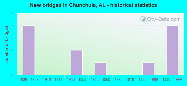
- New bridges - historical statistics
- 41930-1939
- 21950-1959
- 11960-1969
- 11980-1989
- 41990-1999

- Reconstructed bridges - Historical Statistics
- 11980-1989
- 11990-1999


- Bridge Condition - Deck
- 20.0%Good
- 40.0%Satisfactory
- 40.0%Fair

- Bridge Condition - Superstructure
- 20.0%Good
- 60.0%Satisfactory
- 20.0%Fair

- Bridge Condition - Substructure
- 20.0%Good
- 40.0%Satisfactory
- 20.0%Fair
- 20.0%Poor

- Bridge Condition - Channel
- 25.0%Good
- 50.0%Satisfactory
- 25.0%Fair

- Bridge Condition - Culverts
- 28.6%Good
- 57.1%Satisfactory
- 14.3%Fair
Find on map >> Show street view
Structure Number: 779, Location: 5.2 MI EAST OF JCT US 82 (Lat: 33.363683, Lng: -87.954881), Route carried "on" structure: County highway 30, Year Built: 1930, Status: Posted for load, Structure Length: 5.36m (17.59ft), Average Daily Traffic: 500 (year 1998), Truck Traffic: 3%, Average Future Daily Traffic: 550 (year 2034), Features Intersected: BEAR CREEK
Minimum Vertical Clearance: 30+ m (98+ ft), Kilometerpoint: 0.000, Lanes on structure: 2, Owner: County Highway Agency, Approaching Roadway Width: 9.1m (29.9ft), Material/Design: Wood or Timber, Design/Construction: Stringer/Multi-beam, Number Of Spans In Main Unit: 11, Length of Maximum Span: 4.9m (16.1ft), Curb-To-Curb Width: 6.7m (22.0ft), Out-to-Out Width: 7.3m (24.0ft)
Condition: Deck: Fair, Superstructure: Satisfactory, Substructure: Poor, Channel: Satisfactory, Operating Rating: 14.8 metric tons, Method Used To Determine Operating Rating: Allowable Stress (AS), Inventory Rating: 10.6 metric tons, Method Used To Determine Inventory Rating: Allowable Stress (AS), Structural Evaluation: High priority of replacement, Deck Geometry: Meets minimum limits, Waterway Adequacy: Equal to present minimum criteria, Approach Roadway Alignment: Equal to present minimum criteria, Bridge Posting: Required (Relationship of Operating Rating to Maximum Legal Load: > 39.9% below), Length Of Structure Improvement: 6.39m (20.96ft), Designated Inspection Frequency: Every 24 months, Other Special Inspection Frequency: Every 12 months, Inspection Date: November 2021, Other Special Inspection Date: November 2021, Bridge Improvement Cost: $1,052,000, Roadway Improvement Cost: $105,000, Total Project Cost: $1,157,000 ( Estimate for 2022), Deck Structure Type: Concrete Cast-file-Place
Find on map >> Show street view
Structure Number: 9, Location: 0.6 MI S CO RD 63 (Lat: 30.913083, Lng: -88.199747), Route carried "on" structure: US 45, Year Built: 1931, Status: Open, Structure Length: 0.64m (2.10ft), Average Daily Traffic: 8,777 (year 2018), Truck Traffic: 12%, Average Future Daily Traffic: 13,166 (year 2038), Design Load: H 15, Features Intersected: HURRICANE BRANCH
Minimum Vertical Clearance: 30+ m (98+ ft), Kilometerpoint: 29.419, Lanes on structure: 2, Base Highway Network: Yes, Owner: State Highway Agency, Approaching Roadway Width: 8.5m (27.9ft), Material/Design: Concrete, Design/Construction: Culvert, Number Of Spans In Main Unit: 2, Length of Maximum Span: 3.0m (9.8ft)
Condition: Channel: Fair, Culverts: Satisfactory, Operating Rating: 75.4 metric tons, Method Used To Determine Operating Rating: Load Factor (LF), Inventory Rating: 45.2 metric tons, Method Used To Determine Inventory Rating: Load Factor (LF), Structural Evaluation: Equal to present minimum criteria, Waterway Adequacy: Equal to present minimum criteria, Approach Roadway Alignment: Better than present minimum criteria, Length Of Structure Improvement: 1.26m (4.13ft), Designated Inspection Frequency: Every 24 months, Inspection Date: July 2020, Bridge Improvement Cost: $262,000, Roadway Improvement Cost: $26,000, Total Project Cost: $288,000 ( Estimate for 2022)
Find on map >> Show street view
Structure Number: 901, Location: 1.7 MI N CO RD 63 (Lat: 30.942144, Lng: -88.215208), Route carried "on" structure: US 45, Year Built: 1931, Status: Open, Structure Length: 0.64m (2.10ft), Average Daily Traffic: 6,910 (year 2018), Truck Traffic: 13%, Average Future Daily Traffic: 10,365 (year 2038), Design Load: H 15, Features Intersected: CHUNCHULA BRANCH
Minimum Vertical Clearance: 7.56m (24.80ft), Kilometerpoint: 33.186, Lanes on structure: 2, Base Highway Network: Yes, Owner: State Highway Agency, Approaching Roadway Width: 8.5m (27.9ft), Material/Design: Concrete, Design/Construction: Culvert, Number Of Spans In Main Unit: 2, Length of Maximum Span: 3.0m (9.8ft)
Condition: Channel: Satisfactory, Culverts: Satisfactory, Operating Rating: 62.1 metric tons, Method Used To Determine Operating Rating: Load Factor (LF), Inventory Rating: 41.8 metric tons, Method Used To Determine Inventory Rating: Load Factor (LF), Structural Evaluation: Equal to present minimum criteria, Waterway Adequacy: Equal to present minimum criteria, Approach Roadway Alignment: Better than present minimum criteria, Length Of Structure Improvement: 1.26m (4.13ft), Designated Inspection Frequency: Every 24 months, Inspection Date: July 2020, Bridge Improvement Cost: $262,000, Roadway Improvement Cost: $26,000, Total Project Cost: $288,000 ( Estimate for 2022)
Find on map >> Show street view
Structure Number: 4902, Location: 0.4 MI E US 45 (Lat: 30.922106, Lng: -88.193069), Route carried "on" structure: County highway 63, Year Built: 1954, Status: Posted for load, Structure Length: 10.44m (34.25ft), Average Daily Traffic: 1,955 (year 2021), Truck Traffic: 13%, Average Future Daily Traffic: 2,905 (year 2041), Design Load: H 15, Features Intersected: CHICKASAW CREEK, Facility Carried by Structure: ROBERTS ROAD
Minimum Vertical Clearance: 30+ m (98+ ft), Kilometerpoint: 0.000, Lanes on structure: 2, Owner: County Highway Agency, Approaching Roadway Width: 7.2m (23.6ft), Material/Design: Concrete, Design/Construction: Tee Beam, Number Of Spans In Main Unit: 9, Length of Maximum Span: 11.6m (38.1ft), Curb or Sidewalk Widths: Left: 0.5m (1.6ft), Right: 0.5m (1.6ft), Curb-To-Curb Width: 7.3m (24.0ft), Out-to-Out Width: 8.4m (27.6ft)
Condition: Deck: Satisfactory, Superstructure: Satisfactory, Substructure: Satisfactory, Channel: Fair, Operating Rating: 32.0 metric tons, Method Used To Determine Operating Rating: Load Factor (LF), Inventory Rating: 19.2 metric tons, Method Used To Determine Inventory Rating: Load Factor (LF), Structural Evaluation: Somewhat better than minimum adequacy, Deck Geometry: Meets minimum limits, Waterway Adequacy: Better than present minimum criteria, Approach Roadway Alignment: Equal to present desirable criteria, Bridge Posting: Required (Relationship of Operating Rating to Maximum Legal Load: 10.0 - 19.9% below), Length Of Structure Improvement: 11.35m (37.24ft), Designated Inspection Frequency: Every 24 months, Underwater Inspection Frequency: Every 24 months, Other Special Inspection Frequency: Every 12 months, Inspection Date: October 2020, Underwater Inspection Date: October 2020, Other Special Inspection Date: October 2021, Bridge Improvement Cost: $2,101,000, Roadway Improvement Cost: $210,000, Total Project Cost: $2,311,000 ( Estimate for 2022), Deck Structure Type: Concrete Cast-file-Place
Find on map >> Show street view
Structure Number: 9269, Location: 1.4 MI N SR 158 (Lat: 30.820119, Lng: -88.096242), Route carried "on" structure: Interstate 65, Year Built: 1967, Status: Open, Structure Length: 1.52m (4.99ft), Average Daily Traffic: 51,074 (year 2018), Truck Traffic: 14%, Average Future Daily Traffic: 76,611 (year 2038), Design Load: HS 20, Features Intersected: NORTON CREEK
Minimum Vertical Clearance: 30+ m (98+ ft), Kilometerpoint: 22.437, Lanes on structure: 4, Base Highway Network: Yes, Owner: State Highway Agency, Approaching Roadway Width: 36.0m (118.1ft), Skew: 10 degrees, Material/Design: Concrete, Design/Construction: Culvert, Number Of Spans In Main Unit: 4, Length of Maximum Span: 3.7m (12.1ft)
Condition: Channel: Fair, Culverts: Fair, Operating Rating: 86.7 metric tons, Method Used To Determine Operating Rating: Load Factor (LF), Inventory Rating: 46.1 metric tons, Method Used To Determine Inventory Rating: Load Factor (LF), Structural Evaluation: Somewhat better than minimum adequacy, Waterway Adequacy: Equal to present minimum criteria, Approach Roadway Alignment: Equal to present desirable criteria, Length Of Structure Improvement: 2.20m (7.22ft), Designated Inspection Frequency: Every 24 months, Inspection Date: March 2020, Bridge Improvement Cost: $1,881,000, Roadway Improvement Cost: $188,000, Total Project Cost: $2,069,000 ( Estimate for 2022)
Find on map >> Show street view
Structure Number: 14181, Location: 0.2 MI E OF COUNTY RD 63 (Lat: 30.926247, Lng: -88.168039), Route carried "on" structure: County highway , Year Built: 1987, Status: Open, Structure Length: 0.85m (2.79ft), Average Daily Traffic: 1,415 (year 2020), Truck Traffic: 10%, Average Future Daily Traffic: 2,103 (year 2040), Design Load: HS 20, Features Intersected: MEEKERS CREEK, Facility Carried by Structure: WALTER MOORE ROAD
Minimum Vertical Clearance: 30+ m (98+ ft), Kilometerpoint: 0.200, Lanes on structure: 2, Owner: County Highway Agency, Approaching Roadway Width: 8.6m (28.2ft), Skew: 3 degrees, Material/Design: Concrete, Design/Construction: Culvert, Number Of Spans In Main Unit: 2, Length of Maximum Span: 4.3m (14.1ft)
Condition: Channel: Satisfactory, Culverts: Satisfactory, Operating Rating: 53.5 metric tons, Method Used To Determine Operating Rating: Load Factor (LF), Inventory Rating: 31.8 metric tons, Method Used To Determine Inventory Rating: Load Factor (LF), Structural Evaluation: Equal to present minimum criteria, Waterway Adequacy: Better than present minimum criteria, Approach Roadway Alignment: Equal to present minimum criteria, Length Of Structure Improvement: 1.51m (4.95ft), Designated Inspection Frequency: Every 24 months, Underwater Inspection Frequency: Every 24 months, Inspection Date: October 2020, Underwater Inspection Date: October 2020, Bridge Improvement Cost: $454,000, Roadway Improvement Cost: $45,000, Total Project Cost: $499,000 ( Estimate for 2022)
Find on map >> Show street view
Structure Number: 15006, Location: 4 MI. E. OF WING (Lat: 31.009492, Lng: -86.543539), Route carried "on" structure: County highway 4, Year Built: 1958, Year Reconstructed: 1990, Status: Open, Structure Length: 1.04m (3.41ft), Average Daily Traffic: 1,160 (year 1994), Truck Traffic: 20%, Average Future Daily Traffic: 1,377 (year 2030), Design Load: HS 20, Features Intersected: CROOKED CREEK
Minimum Vertical Clearance: 30+ m (98+ ft), Kilometerpoint: 0.010, Lanes on structure: 2, Owner: County Highway Agency, Approaching Roadway Width: 11.0m (36.1ft), Material/Design: Concrete, Design/Construction: Channel Beam, Number Of Spans In Main Unit: 1, Length of Maximum Span: 10.4m (34.1ft), Curb-To-Curb Width: 8.5m (27.9ft), Out-to-Out Width: 9.3m (30.5ft)
Condition: Deck: Satisfactory, Superstructure: Satisfactory, Substructure: Fair, Channel: Satisfactory, Operating Rating: 74.1 metric tons, Method Used To Determine Operating Rating: Load Factor (LF), Inventory Rating: 44.5 metric tons, Method Used To Determine Inventory Rating: Load Factor (LF), Structural Evaluation: Somewhat better than minimum adequacy, Deck Geometry: Somewhat better than minimum adequacy, Waterway Adequacy: Better than present minimum criteria, Approach Roadway Alignment: Better than present minimum criteria, Length Of Structure Improvement: 1.71m (5.61ft), Designated Inspection Frequency: Every 24 months, Inspection Date: Febuary 2021, Bridge Improvement Cost: $351,000, Roadway Improvement Cost: $35,000, Total Project Cost: $386,000 ( Estimate for 2022), Deck Structure Type: Concrete Precast Panels
Find on map >> Show street view
Structure Number: 15093, Location: 0.3 S CO 63 (Lat: 30.918947, Lng: -88.190581), Route carried "on" structure: County highway , Year Built: 1990, Status: Open, Structure Length: 3.11m (10.20ft), Average Daily Traffic: 78 (year 2020), Average Future Daily Traffic: 116 (year 2040), Design Load: HS 20, Features Intersected: LOG CREEK, Facility Carried by Structure: RUDOLPH GALLASCH
Minimum Vertical Clearance: 30+ m (98+ ft), Kilometerpoint: 0.299, Lanes on structure: 2, Owner: County Highway Agency, Approaching Roadway Width: 4.9m (16.1ft), Material/Design: Concrete, Design/Construction: Channel Beam, Number Of Spans In Main Unit: 3, Length of Maximum Span: 10.4m (34.1ft), Curb-To-Curb Width: 7.5m (24.6ft), Out-to-Out Width: 8.4m (27.6ft)
Condition: Deck: Good, Superstructure: Good, Substructure: Good, Channel: Satisfactory, Operating Rating: 71.7 metric tons, Method Used To Determine Operating Rating: Load Factor (LF), Inventory Rating: 43.0 metric tons, Method Used To Determine Inventory Rating: Load Factor (LF), Structural Evaluation: Better than present minimum criteria, Deck Geometry: Equal to present minimum criteria, Waterway Adequacy: Better than present minimum criteria, Approach Roadway Alignment: Equal to present desirable criteria, Length Of Structure Improvement: 3.96m (12.99ft), Designated Inspection Frequency: Every 24 months, Inspection Date: October 2020, Bridge Improvement Cost: $733,000, Roadway Improvement Cost: $73,000, Total Project Cost: $806,000 ( Estimate for 2022), Deck Structure Type: Concrete Precast Panels
Find on map >> Show street view
Structure Number: 15435, Location: 2.3 MI N CO RD 63 (Lat: 30.948761, Lng: -88.223203), Route carried "on" structure: US 45, Year Built: 1991, Status: Open, Structure Length: 1.37m (4.49ft), Average Daily Traffic: 7,266 (year 2019), Truck Traffic: 8%, Average Future Daily Traffic: 10,899 (year 2039), Design Load: HS 20, Features Intersected: BEAVER POND CREEK
Minimum Vertical Clearance: 30+ m (98+ ft), Kilometerpoint: 34.256, Lanes on structure: 2, Base Highway Network: Yes, Owner: State Highway Agency, Approaching Roadway Width: 9.1m (29.9ft), Skew: 1 degrees, Material/Design: Concrete, Design/Construction: Culvert, Number Of Spans In Main Unit: 3, Length of Maximum Span: 4.3m (14.1ft), Curb-To-Curb Width: 13.3m (43.6ft), Out-to-Out Width: 14.5m (47.6ft)
Condition: Channel: Good, Culverts: Good, Operating Rating: 78.5 metric tons, Method Used To Determine Operating Rating: Load Factor (LF), Inventory Rating: 47.1 metric tons, Method Used To Determine Inventory Rating: Load Factor (LF), Structural Evaluation: Better than present minimum criteria, Deck Geometry: Somewhat better than minimum adequacy, Waterway Adequacy: Equal to present minimum criteria, Approach Roadway Alignment: Equal to present desirable criteria, Length Of Structure Improvement: 2.05m (6.73ft), Designated Inspection Frequency: Every 24 months, Underwater Inspection Frequency: Every 24 months, Inspection Date: September 2020, Underwater Inspection Date: September 2020, Bridge Improvement Cost: $591,000, Roadway Improvement Cost: $59,000, Total Project Cost: $650,000 ( Estimate for 2022)
Find on map >> Show street view
Structure Number: 15498, Location: 2.8 MI N CO RD 55 (Lat: 30.878564, Lng: -88.198011), Route carried "on" structure: US 45, Year Built: 1931, Year Reconstructed: 1992, Status: Open, Structure Length: 0.93m (3.05ft), Average Daily Traffic: 7,345 (year 2018), Truck Traffic: 12%, Average Future Daily Traffic: 11,018 (year 2038), Design Load: H 15, Features Intersected: SILVER CREEK RELIEF
Minimum Vertical Clearance: 30+ m (98+ ft), Kilometerpoint: 25.524, Lanes on structure: 2, Base Highway Network: Yes, Owner: State Highway Agency, Approaching Roadway Width: 9.8m (32.2ft), Material/Design: Concrete, Design/Construction: Culvert, Number Of Spans In Main Unit: 3, Length of Maximum Span: 3.0m (9.8ft), Curb-To-Curb Width: 13.4m (44.0ft), Out-to-Out Width: 14.5m (47.6ft)
Condition: Channel: Good, Culverts: Satisfactory, Operating Rating: 77.2 metric tons, Method Used To Determine Operating Rating: Load Factor (LF), Inventory Rating: 46.3 metric tons, Method Used To Determine Inventory Rating: Load Factor (LF), Structural Evaluation: Equal to present minimum criteria, Deck Geometry: Equal to present minimum criteria, Waterway Adequacy: Better than present minimum criteria, Approach Roadway Alignment: Better than present minimum criteria, Length Of Structure Improvement: 1.60m (5.25ft), Designated Inspection Frequency: Every 24 months, Inspection Date: July 2020, Bridge Improvement Cost: $443,000, Roadway Improvement Cost: $44,000, Total Project Cost: $487,000 ( Estimate for 2022)
Find on map >> Show street view
Structure Number: 15542, Location: 2.9 MI N CO RD 55 (Lat: 30.880092, Lng: -88.198106), Route carried "on" structure: US 45, Year Built: 1992, Status: Open, Structure Length: 1.68m (5.51ft), Average Daily Traffic: 8,142 (year 2019), Truck Traffic: 9%, Average Future Daily Traffic: 12,213 (year 2039), Design Load: HS 20, Features Intersected: SILVER CREEK
Minimum Vertical Clearance: 30+ m (98+ ft), Kilometerpoint: 25.682, Lanes on structure: 2, Base Highway Network: Yes, Owner: State Highway Agency, Approaching Roadway Width: 11.0m (36.1ft), Skew: 3 degrees, Material/Design: Concrete, Design/Construction: Culvert, Number Of Spans In Main Unit: 4, Length of Maximum Span: 4.0m (13.1ft), Curb-To-Curb Width: 13.3m (43.6ft), Out-to-Out Width: 14.3m (46.9ft)
Condition: Channel: Good, Culverts: Good, Operating Rating: 88.9 metric tons, Method Used To Determine Operating Rating: Load Factor (LF), Inventory Rating: 67.1 metric tons, Method Used To Determine Inventory Rating: Load Factor (LF), Structural Evaluation: Better than present minimum criteria, Deck Geometry: Somewhat better than minimum adequacy, Waterway Adequacy: Equal to present desirable criteria, Approach Roadway Alignment: Better than present minimum criteria, Length Of Structure Improvement: 2.37m (7.78ft), Designated Inspection Frequency: Every 24 months, Underwater Inspection Frequency: Every 24 months, Inspection Date: September 2020, Underwater Inspection Date: September 2020, Bridge Improvement Cost: $752,000, Roadway Improvement Cost: $75,000, Total Project Cost: $827,000 ( Estimate for 2022)
Find on map >> Show street view
Structure Number: 15557, Location: 1.4 MI E US 45 (Lat: 30.924056, Lng: -88.183542), Route carried "on" structure: County highway 63, Year Built: 1992, Status: Open, Structure Length: 3.11m (10.20ft), Average Daily Traffic: 1,735 (year 2020), Truck Traffic: 10%, Average Future Daily Traffic: 2,578 (year 2040), Design Load: HS 20, Features Intersected: LOG CREEK, Facility Carried by Structure: ROBERTS RD
Minimum Vertical Clearance: 30+ m (98+ ft), Kilometerpoint: 1.399, Lanes on structure: 2, Owner: County Highway Agency, Approaching Roadway Width: 7.6m (24.9ft), Material/Design: Concrete continuous, Design/Construction: Slab, Number Of Spans In Main Unit: 4, Length of Maximum Span: 7.9m (25.9ft), Curb-To-Curb Width: 8.5m (27.9ft), Out-to-Out Width: 9.4m (30.8ft)
Condition: Deck: Fair, Superstructure: Fair, Substructure: Satisfactory, Channel: Satisfactory, Operating Rating: 56.7 metric tons, Method Used To Determine Operating Rating: Load Factor (LF), Inventory Rating: 33.9 metric tons, Method Used To Determine Inventory Rating: Load Factor (LF), Structural Evaluation: Somewhat better than minimum adequacy, Deck Geometry: Somewhat better than minimum adequacy, Waterway Adequacy: Equal to present desirable criteria, Approach Roadway Alignment: Equal to present minimum criteria, Length Of Structure Improvement: 3.96m (12.99ft), Designated Inspection Frequency: Every 24 months, Inspection Date: October 2020, Bridge Improvement Cost: $815,000, Roadway Improvement Cost: $82,000, Total Project Cost: $897,000 ( Estimate for 2022), Deck Structure Type: Concrete Cast-file-Place