Bridge Statistics for Churchill, Pennsylvania (PA)
Condition, Traffic, Stress, Structural Evaluation, Project Costs
- National Bridge Inventory (NBI) Statistics
- 18Number of bridges
- 118ft / 36.3mTotal length
- $6,701,000Total costs
- 426,725Total average daily traffic
- 38,935Total average daily truck traffic
- National Bridge Inventory (NBI) Registered Bridges for Churchill
- No street view available for this location
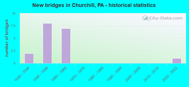
- New bridges - historical statistics
- 21940-1949
- 81950-1959
- 71960-1969
- 12020-2022

- Reconstructed bridges - Historical Statistics
- 41970-1979
- 01980-1989
- 01990-1999
- 32000-2009


- Bridge Condition - Deck
- 57.1%Good
- 28.6%Satisfactory
- 14.3%Fair

- Bridge Condition - Superstructure
- 28.6%Good
- 71.4%Satisfactory

- Bridge Condition - Substructure
- 57.1%Good
- 42.9%Satisfactory

- Bridge Condition - Channel
- 50.0%Very good
- 50.0%Fair
Find on map >> Show street view
Structure Number: 1188, Location: GREENSBURG PIKE OVER PKWY (Lat: 40.450000, Lng: -79.858333), Route carried "on" structure: State highway , Year Built: 1955, Year Reconstructed: 2008, Status: Open, Structure Length: 4.08m (13.39ft), Average Daily Traffic: 6,799 (year 2020), Truck Traffic: 6%, Average Future Daily Traffic: 5,103 (year 2032), Design Load: HS 20, Features Intersected: SR 0376 EB WB, Facility Carried by Structure: GREENSBURG PIKE
Minimum Vertical Clearance: 30+ m (98+ ft), Kilometerpoint: 0.000, Lanes on structure: 4, Lanes under structure: 7, Owner: State Highway Agency, Approaching Roadway Width: 12.8m (42.0ft), Material/Design: Steel, Design/Construction: Stringer/Multi-beam, Number Of Spans In Main Unit: 1, Length of Maximum Span: 39.6m (129.9ft), Curb or Sidewalk Widths: Left: 1.5m (4.9ft), Right: 1.5m (4.9ft), Curb-To-Curb Width: 12.9m (42.3ft), Out-to-Out Width: 16.8m (55.1ft)
Condition: Deck: Good, Superstructure: Satisfactory, Substructure: Good, Inventory Rating: 66.2 metric tons, Method Used To Determine Inventory Rating: Load Factor (LF), Structural Evaluation: Equal to present minimum criteria, Deck Geometry: High priority of replacement, Underclear: High priority of corrective action, Approach Roadway Alignment: Equal to present desirable criteria, Length Of Structure Improvement: 4.10m (13.45ft), Designated Inspection Frequency: Every 24 months, Inspection Date: July 2021, Bridge Improvement Cost: $22,000, Roadway Improvement Cost: $65,000, Total Project Cost: $299,000, Deck Structure Type: Concrete Cast-file-Place, Wearing Surface/Protective System: Wearing Surface: Latex Concrete
Find on map >> Show street view
Structure Number: 1189, Location: CHURCHILL INTERCHANGE (Lat: 40.445322, Lng: -79.848633), Route carried "on" structure: Interstate 376, Year Built: 1950, Year Reconstructed: 2008, Status: Open, Structure Length: 5.36m (17.59ft), Average Daily Traffic: 92,062 (year 2021), Truck Traffic: 17%, Average Future Daily Traffic: 56,787 (year 2032), Design Load: HS 20, Features Intersected: BEULAH ROAD, Facility Carried by Structure: PARKWAY EAST
Minimum Vertical Clearance: 30+ m (98+ ft), Kilometerpoint: 47.975, Lanes on structure: 4, Lanes under structure: 8, Base Highway Network: Yes, Owner: State Highway Agency, Approaching Roadway Width: 21.6m (70.9ft), Skew: 30 degrees, Material/Design: Steel continuous, Design/Construction: Stringer/Multi-beam, Number Of Spans In Main Unit: 3, Length of Maximum Span: 18.3m (60.0ft), Curb or Sidewalk Widths: Left: 0.2m (0.7ft), Right: 0.2m (0.7ft), Curb-To-Curb Width: 22.9m (75.1ft), Out-to-Out Width: 23.8m (78.1ft)
Condition: Deck: Good, Superstructure: Satisfactory, Substructure: Satisfactory, Operating Rating: 50.8 metric tons, Method Used To Determine Operating Rating: Load Factor (LF), Inventory Rating: 30.8 metric tons, Method Used To Determine Inventory Rating: Load Factor (LF), Structural Evaluation: Equal to present minimum criteria, Deck Geometry: Superior to present desirable criteria, Underclear: High priority of corrective action, Approach Roadway Alignment: Better than present minimum criteria, Length Of Structure Improvement: 5.20m (17.06ft), Designated Inspection Frequency: Every 24 months, Inspection Date: July 2021, Bridge Improvement Cost: $24,000, Roadway Improvement Cost: $100,000, Total Project Cost: $321,000, Deck Structure Type: Concrete Cast-file-Place, Wearing Surface/Protective System: Wearing Surface: Latex Concrete
Find on map >> Show street view
Structure Number: 1192, Location: CHURCH HILL INTERCHANGE (Lat: 40.445619, Lng: -79.846658), Route carried "on" structure: Interstate 376, Year Built: 1950, Year Reconstructed: 2008, Status: Open, Structure Length: 4.05m (13.29ft), Average Daily Traffic: 44,204 (year 2021), Truck Traffic: 17%, Average Future Daily Traffic: 24,956 (year 2032), Design Load: HS 20, Features Intersected: SR 2110 SH, Facility Carried by Structure: PARKWAY EAST
Minimum Vertical Clearance: 30+ m (98+ ft), Kilometerpoint: 47.888, Lanes on structure: 2, Lanes under structure: 3, Base Highway Network: Yes, Owner: State Highway Agency, Approaching Roadway Width: 13.4m (44.0ft), Skew: 4 degrees, Material/Design: Steel, Design/Construction: Girder and Floorbeam System, Number Of Spans In Main Unit: 1, Length of Maximum Span: 39.3m (128.9ft), Curb or Sidewalk Widths: Left: 0.2m (0.7ft), Right: 0.2m (0.7ft), Curb-To-Curb Width: 12.5m (41.0ft), Out-to-Out Width: 13.9m (45.6ft)
Condition: Deck: Good, Superstructure: Satisfactory, Substructure: Satisfactory, Operating Rating: 56.2 metric tons, Method Used To Determine Operating Rating: Load Factor (LF), Inventory Rating: 33.6 metric tons, Method Used To Determine Inventory Rating: Load Factor (LF), Structural Evaluation: Equal to present minimum criteria, Deck Geometry: Better than present minimum criteria, Underclear: Meets minimum limits, Approach Roadway Alignment: Better than present minimum criteria, Length Of Structure Improvement: 4.00m (13.12ft), Designated Inspection Frequency: Every 24 months, Critical Feature Inspection Frequency: Every 24 months, Inspection Date: July 2021, Critical Feature Inspection Date: July 2021, Bridge Improvement Cost: $28,000, Roadway Improvement Cost: $82,000, Total Project Cost: $377,000, Deck Structure Type: Concrete Cast-file-Place, Wearing Surface/Protective System: Wearing Surface: Monolithic Concrete, Deck Protection: Galvanized Reinforcing
Find on map >> Show street view
Structure Number: 1197, Location: 376 OVER WB RAMP A (Lat: 40.442333, Lng: -79.838167), Route carried "on" structure: Interstate 376, Year Built: 1961, Year Reconstructed: 1976, Status: Open, Structure Length: 2.38m (7.81ft), Average Daily Traffic: 48,591 (year 2022), Truck Traffic: 8%, Average Future Daily Traffic: 66,110 (year 2032), Design Load: HS 20, Features Intersected: RAMP A WB, Facility Carried by Structure: PARKWAY EAST
Minimum Vertical Clearance: 30+ m (98+ ft), Kilometerpoint: 49.584, Lanes on structure: 6, Lanes under structure: 2, Base Highway Network: Yes, Owner: State Highway Agency, Approaching Roadway Width: 21.9m (71.9ft), Skew: 35 degrees, Material/Design: Steel, Design/Construction: Stringer/Multi-beam, Number Of Spans In Main Unit: 1, Length of Maximum Span: 22.9m (75.1ft), Curb or Sidewalk Widths: Left: 0.2m (0.7ft), Right: 0.2m (0.7ft), Curb-To-Curb Width: 25.6m (84.0ft), Out-to-Out Width: 27.0m (88.6ft)
Condition: Deck: Satisfactory, Superstructure: Good, Substructure: Good, Operating Rating: 70.8 metric tons, Method Used To Determine Operating Rating: Load Factor (LF), Inventory Rating: 42.6 metric tons, Method Used To Determine Inventory Rating: Load Factor (LF), Structural Evaluation: Better than present minimum criteria, Deck Geometry: Meets minimum limits, Underclear: Equal to present minimum criteria, Approach Roadway Alignment: Equal to present desirable criteria, Length Of Structure Improvement: 2.40m (7.87ft), Designated Inspection Frequency: Every 24 months, Inspection Date: July 2021, Bridge Improvement Cost: $22,000, Roadway Improvement Cost: $65,000, Total Project Cost: $299,000, Deck Structure Type: Concrete Cast-file-Place, Wearing Surface/Protective System: Wearing Surface: Latex Concrete, Deck Protection: Epoxy Coated Reinforcing
Find on map >> Show street view
Structure Number: 1198, Location: 1/2 MI. N.E. OF SR 2048 (Lat: 40.440278, Lng: -79.833681), Route carried "on" structure: Interstate 376, Year Built: 1962, Year Reconstructed: 1976, Status: Open, Structure Length: 10.12m (33.20ft), Average Daily Traffic: 69,028 (year 2022), Truck Traffic: 8%, Average Future Daily Traffic: 66,083 (year 2032), Design Load: HS 20, Features Intersected: LR 395-RODI ROAD NB&SB, Facility Carried by Structure: PENN LINCOLN PY
Minimum Vertical Clearance: 30+ m (98+ ft), Kilometerpoint: 49.584, Lanes on structure: 6, Lanes under structure: 8, Base Highway Network: Yes, Owner: State Highway Agency, Approaching Roadway Width: 30.5m (100.1ft), Skew: 31 degrees, Material/Design: Prestressed concrete, Design/Construction: Box Beam or Girders - Multiple, Number Of Spans In Main Unit: 4, Length of Maximum Span: 27.1m (88.9ft), Curb or Sidewalk Widths: Left: 0.2m (0.7ft), Right: 0.2m (0.7ft), Curb-To-Curb Width: 29.6m (97.1ft), Out-to-Out Width: 31.4m (103.0ft)
Condition: Deck: Good, Superstructure: Satisfactory, Substructure: Good, Operating Rating: 92.5 metric tons, Method Used To Determine Operating Rating: Load Factor (LF), Inventory Rating: 19.1 metric tons, Method Used To Determine Inventory Rating: Load Factor (LF), Structural Evaluation: Meets minimum limits, Deck Geometry: Superior to present desirable criteria, Underclear: Superior to present desirable criteria, Approach Roadway Alignment: Equal to present desirable criteria, Length Of Structure Improvement: 10.10m (33.14ft), Designated Inspection Frequency: Every 24 months, Inspection Date: July 2021, Bridge Improvement Cost: $310,000, Roadway Improvement Cost: $912,000, Total Project Cost: $4,180,000, Deck Structure Type: Concrete Cast-file-Place, Wearing Surface/Protective System: Wearing Surface: Latex Concrete, Deck Protection: Epoxy Coated Reinforcing
Find on map >> Show street view
Structure Number: 1574, Location: OVER SR 2053 (Lat: 40.433514, Lng: -79.820614), Route carried "on" structure: US 22B, Year Built: 1941, Year Reconstructed: 1978, Status: Open, Structure Length: 8.11m (26.61ft), Average Daily Traffic: 34,740 (year 2021), Truck Traffic: 4%, Average Future Daily Traffic: 36,265 (year 2032), Design Load: HS 20, Features Intersected: LR 395 & CHALFONT RUN, Facility Carried by Structure: WILLIAM PENN HY
Minimum Vertical Clearance: 30+ m (98+ ft), Kilometerpoint: 1.646, Lanes on structure: 4, Lanes under structure: 2, Base Highway Network: Yes, Owner: State Highway Agency, Approaching Roadway Width: 19.5m (64.0ft), Skew: 29 degrees, Material/Design: Steel, Design/Construction: Girder and Floorbeam System, Number Of Spans In Main Unit: 2, Number Of Approach Spans: 1, Length of Maximum Span: 32.6m (107.0ft), Curb or Sidewalk Widths: Left: 1.5m (4.9ft), Right: 1.5m (4.9ft), Curb-To-Curb Width: 18.0m (59.1ft), Out-to-Out Width: 22.3m (73.2ft)
Condition: Deck: Fair, Superstructure: Satisfactory, Substructure: Satisfactory, Channel: Fair, Operating Rating: 45.4 metric tons, Method Used To Determine Operating Rating: Load Factor (LF), Inventory Rating: 27.2 metric tons, Method Used To Determine Inventory Rating: Load Factor (LF), Structural Evaluation: Equal to present minimum criteria, Deck Geometry: Somewhat better than minimum adequacy, Underclear: Somewhat better than minimum adequacy, Waterway Adequacy: Superior to present desirable criteria, Approach Roadway Alignment: Equal to present desirable criteria, Length Of Structure Improvement: 8.10m (26.57ft), Designated Inspection Frequency: Every 24 months, Critical Feature Inspection Frequency: Every 24 months, Inspection Date: July 2020, Critical Feature Inspection Date: July 2020, Bridge Improvement Cost: $91,000, Roadway Improvement Cost: $267,000, Total Project Cost: $1,225,000, Deck Structure Type: Concrete Cast-file-Place, Wearing Surface/Protective System: Wearing Surface: Epoxy Overlay, Deck Protection: Epoxy Coated Reinforcing
Find on map >> Show street view
Structure Number: 2794, Location: RAMP D OVER RODI RD.N.B. (Lat: 40.441522, Lng: -79.828453), Route carried "on" structure: Ramp State highway , Year Built: 1962, Year Reconstructed: 1977, Status: Open, Structure Length: 1.43m (4.69ft), Average Daily Traffic: 1,863 (year 2021), Truck Traffic: 7%, Average Future Daily Traffic: 2,584 (year 2032), Design Load: HS 20, Features Intersected: RODI RD NB, Facility Carried by Structure: RAMP D
Minimum Vertical Clearance: 30+ m (98+ ft), Kilometerpoint: 0.000, Lanes on structure: 1, Lanes under structure: 1, Base Highway Network: Yes, Owner: State Highway Agency, Approaching Roadway Width: 9.8m (32.2ft), Skew: 4 degrees, Material/Design: Steel, Design/Construction: Stringer/Multi-beam, Number Of Spans In Main Unit: 1, Length of Maximum Span: 13.4m (44.0ft), Curb or Sidewalk Widths: Left: 0.2m (0.7ft), Right: 0.2m (0.7ft), Curb-To-Curb Width: 9.1m (29.9ft), Out-to-Out Width: 10.4m (34.1ft)
Condition: Deck: Satisfactory, Superstructure: Good, Substructure: Good, Operating Rating: 55.3 metric tons, Method Used To Determine Operating Rating: Load Factor (LF), Inventory Rating: 32.7 metric tons, Method Used To Determine Inventory Rating: Load Factor (LF), Structural Evaluation: Better than present minimum criteria, Deck Geometry: Superior to present desirable criteria, Underclear: Meets minimum limits, Approach Roadway Alignment: Equal to present minimum criteria, Length Of Structure Improvement: 1.40m (4.59ft), Designated Inspection Frequency: Every 24 months, Inspection Date: July 2021, Deck Structure Type: Concrete Cast-file-Place, Wearing Surface/Protective System: Wearing Surface: Latex Concrete, Deck Protection: Epoxy Coated Reinforcing
Find on map >> Show street view
Structure Number: 67521, Location: 500' SO. OF BUS. RT.22 (Lat: 40.433194, Lng: -79.820903), Route carried "on" structure: State highway , Year Built: 2020, Status: Open, Structure Length: 0.79m (2.59ft), Average Daily Traffic: 1,592 (year 2022), Truck Traffic: 5%, Average Future Daily Traffic: 2,000 (year 2040), Design Load: HL 93, Features Intersected: CHALFONT RUN, Facility Carried by Structure: SOUTH BEND LANE
Minimum Vertical Clearance: 30+ m (98+ ft), Kilometerpoint: 0.048, Lanes on structure: 2, Owner: State Highway Agency, Approaching Roadway Width: 9.1m (29.9ft), Skew: 4 degrees, Material/Design: Concrete, Design/Construction: Culvert, Number Of Spans In Main Unit: 1, Length of Maximum Span: 7.9m (25.9ft)
Condition: Channel: Very good, Culverts: Very good, Operating Rating: 60.3 metric tons, Method Used To Determine Operating Rating: Assigned ratings based on Load and Resistance Factor Design (LRFD) reported by rating factor (RF) using HL93 loadings, Inventory Rating: 37.9 metric tons, Method Used To Determine Inventory Rating: Assigned ratings based on Load and Resistance Factor Design (LRFD) reported by rating factor (RF) using HL93 loadings, Structural Evaluation: Equal to present desirable criteria, Waterway Adequacy: Equal to present minimum criteria, Approach Roadway Alignment: Equal to present desirable criteria, Designated Inspection Frequency: Every 24 months, Inspection Date: July 2020
Find on map >> Show street view
Structure Number: 1188, Location: GREENSBURG PIKE OVER PKWY (Lat: 40.450000, Lng: -79.858333), Route carried "under" structure: Interstate 376, Year Built: 1955, Structure Length: 0. m, Average Daily Traffic: 47,862 (year 2022), Truck Traffic: 4%, Features Intersected: SR 0376 EB WB, Facility Carried by Structure: GREENSBURG PIKE
Minimum Vertical Clearance: 4.42m (14.50ft), Kilometerpoint: 47.281, Lanes on structure: 4, Lanes under structure: 4, Material/Design: Steel, Design/Construction: Stringer/Multi-beam, Length of Maximum Span: 39.6m (129.9ft)
Find on map >> Show street view
Structure Number: 1188, Location: GREENSBURG PIKE OVER PKWY (Lat: 40.450000, Lng: -79.858333), Route carried "under" structure: Interstate 376, Year Built: 1955, Structure Length: 0. m, Average Daily Traffic: 32,680 (year 2022), Truck Traffic: 5%, Features Intersected: SR 0376 EB WB, Facility Carried by Structure: GREENSBURG PIKE
Minimum Vertical Clearance: 4.42m (14.50ft), Kilometerpoint: 47.083, Lanes on structure: 4, Lanes under structure: 3, Material/Design: Steel, Design/Construction: Stringer/Multi-beam, Length of Maximum Span: 39.6m (129.9ft)
Find on map >> Show street view
Structure Number: 1189, Location: CHURCHILL INTERCHANGE (Lat: 40.445322, Lng: -79.848633), Route carried "under" structure: State highway 130, Year Built: 1950, Structure Length: 0. m, Average Daily Traffic: 3,858 (year 2020), Truck Traffic: 2%, Features Intersected: BEULAH ROAD, Facility Carried by Structure: PARKWAY EAST
Minimum Vertical Clearance: 4.78m (15.68ft), Kilometerpoint: 9.793, Lanes on structure: 4, Lanes under structure: 4, Material/Design: Steel continuous, Design/Construction: Stringer/Multi-beam, Length of Maximum Span: 18.3m (60.0ft)
Find on map >> Show street view
Structure Number: 1189, Location: CHURCHILL INTERCHANGE (Lat: 40.445322, Lng: -79.848633), Route carried "under" structure: State highway 130, Year Built: 1950, Structure Length: 0. m, Average Daily Traffic: 3,858 (year 2020), Truck Traffic: 2%, Features Intersected: BEULAH ROAD, Facility Carried by Structure: PARKWAY EAST
Minimum Vertical Clearance: 4.78m (15.68ft), Kilometerpoint: 9.786, Lanes on structure: 4, Lanes under structure: 4, Material/Design: Steel continuous, Design/Construction: Stringer/Multi-beam, Length of Maximum Span: 18.3m (60.0ft)
Find on map >> Show street view
Structure Number: 1192, Location: CHURCH HILL INTERCHANGE (Lat: 40.445619, Lng: -79.846658), Route carried "under" structure: State highway , Year Built: 1950, Structure Length: 0. m, Average Daily Traffic: 9,979 (year 2020), Truck Traffic: 3%, Features Intersected: SR 2110 SH, Facility Carried by Structure: PARKWAY EAST
Minimum Vertical Clearance: 4.27m (14.01ft), Kilometerpoint: 2.580, Lanes on structure: 2, Lanes under structure: 3, Material/Design: Steel, Design/Construction: Girder and Floorbeam System, Length of Maximum Span: 39.3m (128.9ft)
Find on map >> Show street view
Structure Number: 1197, Location: 376 OVER WB RAMP A (Lat: 40.442333, Lng: -79.838167), Route carried "under" structure: Ramp US 22B, Year Built: 1961, Structure Length: 0. m, Average Daily Traffic: 11,395 (year 2022), Truck Traffic: 1%, Features Intersected: RAMP A WB, Facility Carried by Structure: PARKWAY EAST
Minimum Vertical Clearance: 4.44m (14.57ft), Kilometerpoint: 0.000, Lanes on structure: 6, Lanes under structure: 2, Material/Design: Steel, Design/Construction: Stringer/Multi-beam, Length of Maximum Span: 22.9m (75.1ft)
Find on map >> Show street view
Structure Number: 1198, Location: 1/2 MI. N.E. OF SR 2048 (Lat: 40.440278, Lng: -79.833681), Route carried "under" structure: State highway 791, Year Built: 1962, Structure Length: 0. m, Average Daily Traffic: 5,547 (year 2020), Truck Traffic: 1%, Features Intersected: LR 395-RODI ROAD NB&SB, Facility Carried by Structure: PENN LINCOLN PY
Minimum Vertical Clearance: 9.14m (29.99ft), Kilometerpoint: 0.267, Lanes on structure: 6, Lanes under structure: 4, Material/Design: Prestressed concrete, Design/Construction: Box Beam or Girders - Multiple, Length of Maximum Span: 27.1m (88.9ft)
Find on map >> Show street view
Structure Number: 1574, Location: OVER SR 2053 (Lat: 40.433514, Lng: -79.820614), Route carried "under" structure: State highway , Year Built: 1941, Structure Length: 0. m, Average Daily Traffic: 1,573 (year 2022), Truck Traffic: 5%, Features Intersected: LR 395 & CHALFONT RUN, Facility Carried by Structure: WILLIAM PENN HY
Minimum Vertical Clearance: 4.98m (16.34ft), Kilometerpoint: 1.059, Lanes on structure: 4, Lanes under structure: 2, Material/Design: Steel, Design/Construction: Girder and Floorbeam System, Length of Maximum Span: 32.6m (107.0ft)
Find on map >> Show street view
Structure Number: 2794, Location: RAMP D OVER RODI RD.N.B. (Lat: 40.441522, Lng: -79.828453), Route carried "under" structure: State highway 791, Year Built: 1962, Structure Length: 0. m, Average Daily Traffic: 5,547 (year 2020), Truck Traffic: 1%, Features Intersected: RODI RD NB, Facility Carried by Structure: RAMP D
Minimum Vertical Clearance: 4.37m (14.34ft), Kilometerpoint: 0.267, Lanes on structure: 1, Lanes under structure: 1, Material/Design: Steel, Design/Construction: Stringer/Multi-beam, Length of Maximum Span: 13.4m (44.0ft)