Bridge Statistics for Cicero, New York (NY)
Condition, Traffic, Stress, Structural Evaluation, Project Costs
- National Bridge Inventory (NBI) Statistics
- 39Number of bridges
- 384ft / 117mTotal length
- $78,984,000Total costs
- 600,887Total average daily traffic
- 22,862Total average daily truck traffic
- National Bridge Inventory (NBI) Registered Bridges for Cicero
- No street view available for this location
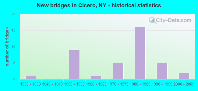
- New bridges - historical statistics
- 11930-1939
- 91950-1959
- 11960-1969
- 51970-1979
- 161980-1989
- 51990-1999
- 22000-2009
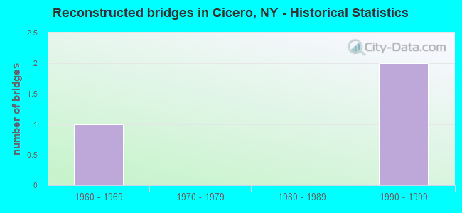
- Reconstructed bridges - Historical Statistics
- 11960-1969
- 01970-1979
- 01980-1989
- 21990-1999
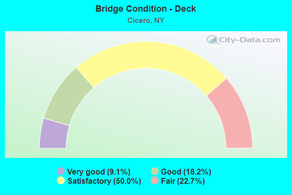
- Bridge Condition - Deck
- 9.1%Very good
- 18.2%Good
- 50.0%Satisfactory
- 22.7%Fair
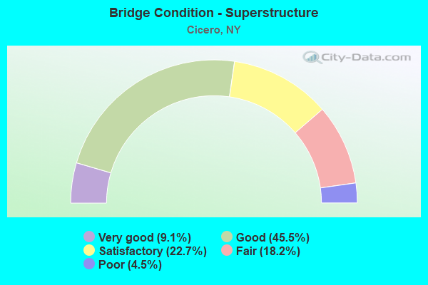
- Bridge Condition - Superstructure
- 9.1%Very good
- 45.5%Good
- 22.7%Satisfactory
- 18.2%Fair
- 4.5%Poor
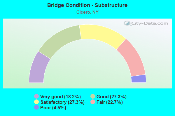
- Bridge Condition - Substructure
- 18.2%Very good
- 27.3%Good
- 27.3%Satisfactory
- 22.7%Fair
- 4.5%Poor
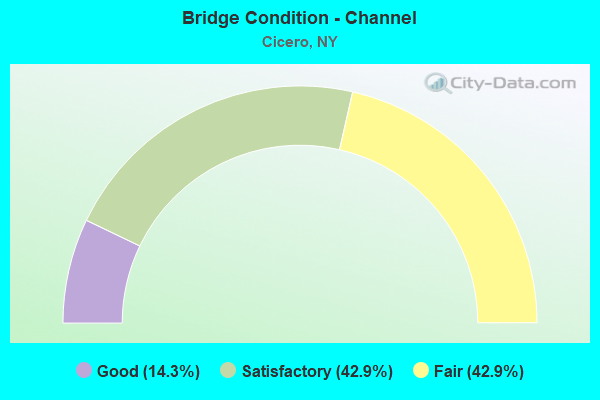
- Bridge Condition - Channel
- 14.3%Good
- 42.9%Satisfactory
- 42.9%Fair
Find on map >> Show street view
Structure Number: 1021961, Location: JCT OF RTS I-81 SB + 31 (Lat: 43.175597, Lng: -76.116089), Route carried "on" structure: Interstate 81, Year Built: 1959, Status: Open, Structure Length: 4.97m (16.31ft), Average Daily Traffic: 24,876 (year 2014), Truck Traffic: 13%, Design Load: HS 20, Features Intersected: RTE 31
Minimum Vertical Clearance: 30+ m (98+ ft), Kilometerpoint: 48.190, Lanes on structure: 3, Lanes under structure: 5, Base Highway Network: Yes, Owner: State Highway Agency, Approaching Roadway Width: 15.2m (49.9ft), Skew: 1 degrees, Material/Design: Steel, Design/Construction: Stringer/Multi-beam, Number Of Spans In Main Unit: 3, Length of Maximum Span: 23.1m (75.8ft), Curb-To-Curb Width: 12.8m (42.0ft), Out-to-Out Width: 14.4m (47.2ft)
Condition: Deck: Fair, Superstructure: Fair, Substructure: Fair, Operating Rating: 68.9 metric tons, Method Used To Determine Operating Rating: Load Factor (LF), Inventory Rating: 40.8 metric tons, Method Used To Determine Inventory Rating: Load Factor (LF), Structural Evaluation: Somewhat better than minimum adequacy, Deck Geometry: High priority of replacement, Underclear: Meets minimum limits, Approach Roadway Alignment: Equal to present desirable criteria, Length Of Structure Improvement: 4.96m (16.27ft), Designated Inspection Frequency: Every 24 months, Inspection Date: November 2020, Bridge Improvement Cost: $1,520,000, Roadway Improvement Cost: $890,000, Total Project Cost: $2,410,000 ( Estimate for 2021), Deck Structure Type: Concrete Cast-file-Place, Wearing Surface/Protective System: Wearing Surface: Monolithic Concrete
Find on map >> Show street view
Structure Number: 1021962, Location: JCT OF RTS I-81 NB + 31 (Lat: 43.175608, Lng: -76.115803), Route carried "on" structure: Interstate 81, Year Built: 1959, Status: Open, Structure Length: 4.97m (16.31ft), Average Daily Traffic: 17,676 (year 2020), Truck Traffic: 12%, Average Future Daily Traffic: 25,497 (year 2040), Design Load: HS 20, Features Intersected: RTE 31
Minimum Vertical Clearance: 30+ m (98+ ft), Kilometerpoint: 48.206, Lanes on structure: 3, Lanes under structure: 5, Base Highway Network: Yes, Owner: State Highway Agency, Approaching Roadway Width: 16.5m (54.1ft), Skew: 1 degrees, Material/Design: Steel, Design/Construction: Stringer/Multi-beam, Number Of Spans In Main Unit: 3, Length of Maximum Span: 23.1m (75.8ft), Curb-To-Curb Width: 12.8m (42.0ft), Out-to-Out Width: 14.4m (47.2ft)
Condition: Deck: Satisfactory, Superstructure: Fair, Substructure: Fair, Operating Rating: 68.9 metric tons, Method Used To Determine Operating Rating: Load Factor (LF), Inventory Rating: 40.8 metric tons, Method Used To Determine Inventory Rating: Load Factor (LF), Structural Evaluation: Somewhat better than minimum adequacy, Deck Geometry: High priority of replacement, Underclear: Meets minimum limits, Approach Roadway Alignment: Equal to present desirable criteria, Length Of Structure Improvement: 4.96m (16.27ft), Designated Inspection Frequency: Every 24 months, Inspection Date: November 2020, Bridge Improvement Cost: $1,520,000, Roadway Improvement Cost: $890,000, Total Project Cost: $2,410,000 ( Estimate for 2021), Deck Structure Type: Concrete Cast-file-Place, Wearing Surface/Protective System: Wearing Surface: Monolithic Concrete
Find on map >> Show street view
Structure Number: 102197, Location: 0.1 MI E JCT RTS 31 & 298 (Lat: 43.155017, Lng: -75.971219), Route carried "on" structure: State highway 31, Year Built: 1999, Status: Open, Structure Length: 6.34m (20.80ft), Average Daily Traffic: 13,168 (year 2020), Truck Traffic: 6%, Average Future Daily Traffic: 15,996 (year 2040), Design Load: HS 25 or greater, Features Intersected: CHITTENANGO CREEK
Minimum Vertical Clearance: 30+ m (98+ ft), Kilometerpoint: 54.497, Lanes on structure: 2, Base Highway Network: Yes, Owner: State Highway Agency, Approaching Roadway Width: 12.2m (40.0ft), Material/Design: Prestressed concrete, Design/Construction: Box Beam or Girders - Multiple, Number Of Spans In Main Unit: 3, Length of Maximum Span: 20.4m (66.9ft), Curb or Sidewalk Widths: Left: 1.8m (5.9ft), Right: 1.8m (5.9ft), Curb-To-Curb Width: 12.2m (40.0ft), Out-to-Out Width: 16.3m (53.5ft)
Condition: Deck: Satisfactory, Superstructure: Good, Substructure: Good, Channel: Satisfactory, Operating Rating: 74.4 metric tons, Method Used To Determine Operating Rating: Load Factor (LF), Inventory Rating: 44.5 metric tons, Method Used To Determine Inventory Rating: Load Factor (LF), Structural Evaluation: Better than present minimum criteria, Deck Geometry: Somewhat better than minimum adequacy, Waterway Adequacy: Somewhat better than minimum adequacy, Approach Roadway Alignment: Equal to present desirable criteria, Length Of Structure Improvement: 6.33m (20.77ft), Designated Inspection Frequency: Every 24 months, Inspection Date: September 2021, Bridge Improvement Cost: $3,273,000, Roadway Improvement Cost: $1,917,000, Total Project Cost: $5,190,000 ( Estimate for 2021), Wearing Surface/Protective System: Wearing Surface: Monolithic Concrete
Find on map >> Show street view
Structure Number: 103169, Location: 1.6 MI NE JCT RTS I-81+11 (Lat: 43.123833, Lng: -76.124078), Route carried "on" structure: County highway , Year Built: 1959, Year Reconstructed: 1999, Status: Open, Structure Length: 9.84m (32.28ft), Average Daily Traffic: 13,191 (year 2017), Truck Traffic: 5%, Average Future Daily Traffic: 13,252 (year 2040), Design Load: HS 20, Features Intersected: 81I 81I33033041 NB, RTE, Facility Carried by Structure: TAFT ROAD
Minimum Vertical Clearance: 30+ m (98+ ft), Kilometerpoint: 1.432, Lanes on structure: 4, Lanes under structure: 9, Owner: State Highway Agency, Approaching Roadway Width: 19.5m (64.0ft), Skew: 24 degrees, Material/Design: Steel, Design/Construction: Stringer/Multi-beam, Number Of Spans In Main Unit: 4, Length of Maximum Span: 31.1m (102.0ft), Curb or Sidewalk Widths: Left: 1.5m (4.9ft), Right: 1.5m (4.9ft), Curb-To-Curb Width: 19.5m (64.0ft), Out-to-Out Width: 23.2m (76.1ft)
Condition: Deck: Fair, Superstructure: Satisfactory, Substructure: Fair, Operating Rating: 67.1 metric tons, Method Used To Determine Operating Rating: Load Factor (LF), Inventory Rating: 35.4 metric tons, Method Used To Determine Inventory Rating: Load Factor (LF), Structural Evaluation: Somewhat better than minimum adequacy, Deck Geometry: Better than present minimum criteria, Underclear: High priority of corrective action, Approach Roadway Alignment: Equal to present desirable criteria, Length Of Structure Improvement: 9.84m (32.28ft), Designated Inspection Frequency: Every 24 months, Inspection Date: August 2020, Bridge Improvement Cost: $4,586,000, Roadway Improvement Cost: $2,685,000, Total Project Cost: $7,271,000 ( Estimate for 2021), Deck Structure Type: Concrete Cast-file-Place, Wearing Surface/Protective System: Wearing Surface: Monolithic Concrete
Find on map >> Show street view
Structure Number: 1031711, Location: JCT OF RTS 481 SB & I-81 (Lat: 43.141411, Lng: -76.112500), Route carried "on" structure: Interstate 481, Year Built: 1986, Status: Open, Structure Length: 8.26m (27.10ft), Average Daily Traffic: 15,976 (year 2007), Truck Traffic: 13%, Design Load: HS 20, Features Intersected: 81I 81I33033056NB, RTE I
Minimum Vertical Clearance: 30+ m (98+ ft), Kilometerpoint: 24.328, Lanes on structure: 3, Lanes under structure: 8, Base Highway Network: Yes, Owner: State Highway Agency, Approaching Roadway Width: 14.6m (47.9ft), Skew: 3 degrees, Material/Design: Steel continuous, Design/Construction: Stringer/Multi-beam, Number Of Spans In Main Unit: 2, Length of Maximum Span: 40.8m (133.9ft), Curb-To-Curb Width: 14.5m (47.6ft), Out-to-Out Width: 15.4m (50.5ft)
Condition: Deck: Satisfactory, Superstructure: Satisfactory, Substructure: Satisfactory, Operating Rating: 83.5 metric tons, Method Used To Determine Operating Rating: Load Factor (LF), Inventory Rating: 49.9 metric tons, Method Used To Determine Inventory Rating: Load Factor (LF), Structural Evaluation: Equal to present minimum criteria, Deck Geometry: Meets minimum limits, Underclear: High priority of corrective action, Approach Roadway Alignment: Equal to present desirable criteria, Length Of Structure Improvement: 8.26m (27.10ft), Designated Inspection Frequency: Every 24 months, Inspection Date: November 2020, Bridge Improvement Cost: $2,577,000, Roadway Improvement Cost: $1,509,000, Total Project Cost: $4,086,000 ( Estimate for 2021), Deck Structure Type: Concrete Cast-file-Place, Wearing Surface/Protective System: Wearing Surface: Integral Concrete, Deck Protection: Epoxy Coated Reinforcing
Find on map >> Show street view
Structure Number: 1031712, Location: JCT OF RTS 481 NB & I-81 (Lat: 43.141600, Lng: -76.112289), Route carried "on" structure: Interstate 481, Year Built: 1986, Status: Open, Structure Length: 8.26m (27.10ft), Average Daily Traffic: 12,957 (year 2018), Truck Traffic: 7%, Average Future Daily Traffic: 18,690 (year 2040), Design Load: HS 20, Features Intersected: 81I 81I33033056NB, RTE I
Minimum Vertical Clearance: 30+ m (98+ ft), Kilometerpoint: 24.328, Lanes on structure: 3, Lanes under structure: 8, Base Highway Network: Yes, Owner: State Highway Agency, Approaching Roadway Width: 13.1m (43.0ft), Skew: 3 degrees, Material/Design: Steel continuous, Design/Construction: Stringer/Multi-beam, Number Of Spans In Main Unit: 2, Length of Maximum Span: 40.8m (133.9ft), Curb-To-Curb Width: 14.5m (47.6ft), Out-to-Out Width: 15.4m (50.5ft)
Condition: Deck: Good, Superstructure: Good, Substructure: Satisfactory, Operating Rating: 83.5 metric tons, Method Used To Determine Operating Rating: Load Factor (LF), Inventory Rating: 49.9 metric tons, Method Used To Determine Inventory Rating: Load Factor (LF), Structural Evaluation: Equal to present minimum criteria, Deck Geometry: Meets minimum limits, Underclear: High priority of corrective action, Approach Roadway Alignment: Equal to present desirable criteria, Length Of Structure Improvement: 8.26m (27.10ft), Designated Inspection Frequency: Every 24 months, Inspection Date: November 2020, Bridge Improvement Cost: $2,676,000, Roadway Improvement Cost: $1,567,000, Total Project Cost: $4,242,000 ( Estimate for 2021), Deck Structure Type: Concrete Cast-file-Place, Wearing Surface/Protective System: Wearing Surface: Integral Concrete, Deck Protection: Epoxy Coated Reinforcing
Find on map >> Show street view
Structure Number: 103172, Location: .6 MI N JCT I81 & SH 481 (Lat: 43.149558, Lng: -76.110239), Route carried "on" structure: County highway , Year Built: 1959, Status: Open, Structure Length: 9.91m (32.51ft), Average Daily Traffic: 9,657 (year 2017), Truck Traffic: 2%, Average Future Daily Traffic: 11,731 (year 2040), Design Load: HS 20, Features Intersected: 81I 81I33033062NB, RTE I, Facility Carried by Structure: SOUTH BAY RD
Minimum Vertical Clearance: 30+ m (98+ ft), Kilometerpoint: 5.165, Lanes on structure: 2, Lanes under structure: 6, Owner: State Highway Agency, Approaching Roadway Width: 10.7m (35.1ft), Skew: 4 degrees, Material/Design: Steel, Design/Construction: Stringer/Multi-beam, Number Of Spans In Main Unit: 4, Length of Maximum Span: 30.4m (99.7ft), Curb or Sidewalk Widths: Left: 0.5m (1.6ft), Right: 0.5m (1.6ft), Curb-To-Curb Width: 9.1m (29.9ft), Out-to-Out Width: 10.8m (35.4ft)
Condition: Deck: Fair, Superstructure: Fair, Substructure: Poor, Operating Rating: 11.3 metric tons, Method Used To Determine Operating Rating: Load and Resistance Factor Rating (LRFR) rating reported by rating factor(RF) method using HL-93 loadings, Inventory Rating: 8.7 metric tons, Method Used To Determine Inventory Rating: Load and Resistance Factor Rating (LRFR) rating reported by rating factor(RF) method using HL-93 loadings, Structural Evaluation: High priority of corrective action, Deck Geometry: Meets minimum limits, Underclear: Meets minimum limits, Approach Roadway Alignment: Equal to present desirable criteria, Length Of Structure Improvement: 9.90m (32.48ft), Designated Inspection Frequency: Every 24 months, Inspection Date: November 2020, Bridge Improvement Cost: $2,102,000, Roadway Improvement Cost: $1,231,000, Total Project Cost: $3,332,000 ( Estimate for 2021), Deck Structure Type: Concrete Cast-file-Place, Wearing Surface/Protective System: Wearing Surface: Bituminous, Membrane: Other
Find on map >> Show street view
Structure Number: 103173, Location: 3 MI N JCT I81 & SH 31 (Lat: 43.217058, Lng: -76.129889), Route carried "on" structure: County highway , Year Built: 1996, Status: Open, Structure Length: 7.92m (25.98ft), Average Daily Traffic: 2,061 (year 2019), Truck Traffic: 7%, Average Future Daily Traffic: 2,885 (year 2039), Design Load: HS 25 or greater, Features Intersected: 81I 81I33033110 NB, RTE, Facility Carried by Structure: MUD MILL ROAD
Minimum Vertical Clearance: 30+ m (98+ ft), Kilometerpoint: 3.685, Lanes on structure: 2, Lanes under structure: 6, Owner: State Highway Agency, Approaching Roadway Width: 10.1m (33.1ft), Material/Design: Steel continuous, Design/Construction: Stringer/Multi-beam, Number Of Spans In Main Unit: 2, Length of Maximum Span: 39.3m (128.9ft), Curb-To-Curb Width: 10.4m (34.1ft), Out-to-Out Width: 11.5m (37.7ft)
Condition: Deck: Good, Superstructure: Good, Substructure: Very good, Operating Rating: 81.6 metric tons, Method Used To Determine Operating Rating: Load Factor (LF), Inventory Rating: 49.0 metric tons, Method Used To Determine Inventory Rating: Load Factor (LF), Structural Evaluation: Better than present minimum criteria, Deck Geometry: Somewhat better than minimum adequacy, Underclear: Equal to present minimum criteria, Approach Roadway Alignment: Equal to present desirable criteria, Length Of Structure Improvement: 7.92m (25.98ft), Designated Inspection Frequency: Every 24 months, Inspection Date: October 2020, Bridge Improvement Cost: $1,744,000, Roadway Improvement Cost: $1,021,000, Total Project Cost: $2,765,000 ( Estimate for 2021), Deck Structure Type: Concrete Cast-file-Place, Wearing Surface/Protective System: Wearing Surface: Integral Concrete, Deck Protection: Epoxy Coated Reinforcing
Find on map >> Show street view
Structure Number: 103174, Location: EXIT 31 OF I81 (Lat: 43.231775, Lng: -76.128842), Route carried "on" structure: County highway , Year Built: 2009, Status: Open, Structure Length: 6.46m (21.19ft), Average Daily Traffic: 5,895 (year 2019), Truck Traffic: 5%, Average Future Daily Traffic: 7,161 (year 2040), Design Load: HL 93, Features Intersected: 81I 81I33033120NB, RTE I, Facility Carried by Structure: BARTELL ROAD
Minimum Vertical Clearance: 30+ m (98+ ft), Kilometerpoint: 3.974, Lanes on structure: 3, Lanes under structure: 7, Owner: State Highway Agency, Approaching Roadway Width: 15.8m (51.8ft), Skew: 3 degrees, Material/Design: Prestressed concrete continuous, Design/Construction: Stringer/Multi-beam, Number Of Spans In Main Unit: 2, Length of Maximum Span: 33.7m (110.6ft), Curb-To-Curb Width: 15.8m (51.8ft), Out-to-Out Width: 16.7m (54.8ft)
Condition: Deck: Very good, Superstructure: Very good, Substructure: Very good, Operating Rating: 49.9 metric tons, Method Used To Determine Operating Rating: Load and Resistance Factor Rating (LRFR) rating reported by rating factor(RF) method using HL-93 loadings, Inventory Rating: 38.6 metric tons, Method Used To Determine Inventory Rating: Load and Resistance Factor Rating (LRFR) rating reported by rating factor(RF) method using HL-93 loadings, Structural Evaluation: Equal to present desirable criteria, Deck Geometry: Better than present minimum criteria, Underclear: High priority of corrective action, Approach Roadway Alignment: Equal to present desirable criteria, Length Of Structure Improvement: 6.46m (21.19ft), Designated Inspection Frequency: Every 24 months, Inspection Date: November 2020, Bridge Improvement Cost: $3,467,000, Roadway Improvement Cost: $2,030,000, Total Project Cost: $5,497,000 ( Estimate for 2021), Deck Structure Type: Concrete Cast-file-Place, Wearing Surface/Protective System: Wearing Surface: Integral Concrete, Deck Protection: Epoxy Coated Reinforcing
Find on map >> Show street view
Structure Number: 104522, Location: 2.3 MI SW JCT RTS 298 &31 (Lat: 43.129011, Lng: -75.992050), Route carried "on" structure: State highway 298, Year Built: 1993, Status: Open, Structure Length: 1.40m (4.59ft), Average Daily Traffic: 8,121 (year 2020), Truck Traffic: 7%, Average Future Daily Traffic: 8,171 (year 2040), Design Load: HS 25 or greater, Features Intersected: TAYLOR COMMISSION DITCH
Minimum Vertical Clearance: 30+ m (98+ ft), Kilometerpoint: 19.453, Lanes on structure: 2, Base Highway Network: Yes, Owner: State Highway Agency, Approaching Roadway Width: 9.1m (29.9ft), Skew: 4 degrees, Material/Design: Prestressed concrete, Design/Construction: Slab, Number Of Spans In Main Unit: 1, Length of Maximum Span: 12.8m (42.0ft), Curb-To-Curb Width: 9.1m (29.9ft), Out-to-Out Width: 9.8m (32.2ft)
Condition: Deck: Very good, Superstructure: Very good, Substructure: Very good, Channel: Fair, Operating Rating: 89.8 metric tons, Method Used To Determine Operating Rating: Load Factor (LF), Inventory Rating: 53.5 metric tons, Method Used To Determine Inventory Rating: Load Factor (LF), Structural Evaluation: Equal to present desirable criteria, Deck Geometry: High priority of corrective action, Waterway Adequacy: Somewhat better than minimum adequacy, Approach Roadway Alignment: Equal to present desirable criteria, Length Of Structure Improvement: 1.40m (4.59ft), Designated Inspection Frequency: Every 24 months, Inspection Date: July 2021, Bridge Improvement Cost: $404,000, Roadway Improvement Cost: $237,000, Total Project Cost: $641,000 ( Estimate for 2021), Wearing Surface/Protective System: Wearing Surface: Bituminous, Membrane: Preformed Fabric
Find on map >> Show street view
Structure Number: 1061701, Location: JCT OF SH 481 SB & US 11 (Lat: 43.147731, Lng: -76.126031), Route carried "on" structure: State highway 481, Year Built: 1972, Status: Open, Structure Length: 3.96m (12.99ft), Average Daily Traffic: 18,122 (year 2020), Truck Traffic: 5%, Average Future Daily Traffic: 23,608 (year 2040), Design Load: HS 20, Features Intersected: RTE 11
Minimum Vertical Clearance: 30+ m (98+ ft), Kilometerpoint: 1.368, Lanes on structure: 2, Lanes under structure: 4, Base Highway Network: Yes, Owner: State Highway Agency, Approaching Roadway Width: 12.2m (40.0ft), Skew: 1 degrees, Material/Design: Steel, Design/Construction: Stringer/Multi-beam, Number Of Spans In Main Unit: 1, Length of Maximum Span: 37.7m (123.7ft), Curb-To-Curb Width: 12.5m (41.0ft), Out-to-Out Width: 13.4m (44.0ft)
Condition: Deck: Good, Superstructure: Good, Substructure: Good, Operating Rating: 97.1 metric tons, Method Used To Determine Operating Rating: Load Factor (LF), Inventory Rating: 58.1 metric tons, Method Used To Determine Inventory Rating: Load Factor (LF), Structural Evaluation: Better than present minimum criteria, Deck Geometry: Better than present minimum criteria, Underclear: High priority of corrective action, Approach Roadway Alignment: Equal to present desirable criteria, Length Of Structure Improvement: 3.96m (12.99ft), Designated Inspection Frequency: Every 24 months, Inspection Date: August 2020, Bridge Improvement Cost: $1,279,000, Roadway Improvement Cost: $749,000, Total Project Cost: $2,027,000 ( Estimate for 2021), Deck Structure Type: Concrete Cast-file-Place, Wearing Surface/Protective System: Wearing Surface: Latex Concrete
Find on map >> Show street view
Structure Number: 1061702, Location: JCT OF SH 481 NB & US 11 (Lat: 43.147942, Lng: -76.125969), Route carried "on" structure: State highway 481, Year Built: 1972, Status: Open, Structure Length: 3.96m (12.99ft), Average Daily Traffic: 18,122 (year 2020), Truck Traffic: 5%, Average Future Daily Traffic: 23,608 (year 2040), Design Load: HS 20, Features Intersected: RTE 11
Minimum Vertical Clearance: 30+ m (98+ ft), Kilometerpoint: 1.368, Lanes on structure: 3, Lanes under structure: 4, Base Highway Network: Yes, Owner: State Highway Agency, Approaching Roadway Width: 15.8m (51.8ft), Skew: 1 degrees, Material/Design: Steel, Design/Construction: Stringer/Multi-beam, Number Of Spans In Main Unit: 1, Length of Maximum Span: 37.7m (123.7ft), Curb-To-Curb Width: 17.1m (56.1ft), Out-to-Out Width: 18.7m (61.4ft)
Condition: Deck: Good, Superstructure: Satisfactory, Substructure: Good, Operating Rating: 95.3 metric tons, Method Used To Determine Operating Rating: Load Factor (LF), Inventory Rating: 57.2 metric tons, Method Used To Determine Inventory Rating: Load Factor (LF), Structural Evaluation: Equal to present minimum criteria, Deck Geometry: Equal to present minimum criteria, Underclear: Somewhat better than minimum adequacy, Approach Roadway Alignment: Equal to present desirable criteria, Length Of Structure Improvement: 3.96m (12.99ft), Designated Inspection Frequency: Every 24 months, Inspection Date: August 2020, Bridge Improvement Cost: $1,805,000, Roadway Improvement Cost: $1,057,000, Total Project Cost: $2,862,000 ( Estimate for 2021), Deck Structure Type: Concrete Cast-file-Place, Wearing Surface/Protective System: Wearing Surface: Latex Concrete
Find on map >> Show street view
Structure Number: 1072591, Location: 1.5 MI E JCT I81 & I481 (Lat: 43.136311, Lng: -76.082856), Route carried "on" structure: Interstate 481, Year Built: 1986, Status: Open, Structure Length: 5.97m (19.59ft), Average Daily Traffic: 16,353 (year 2015), Truck Traffic: 13%, Design Load: HS 20, Features Intersected: Northern Blvd CR82, NORT
Minimum Vertical Clearance: 30+ m (98+ ft), Kilometerpoint: 21.866, Lanes on structure: 2, Lanes under structure: 4, Base Highway Network: Yes, Owner: State Highway Agency, Approaching Roadway Width: 12.8m (42.0ft), Skew: 3 degrees, Material/Design: Steel, Design/Construction: Stringer/Multi-beam, Number Of Spans In Main Unit: 1, Length of Maximum Span: 58.2m (190.9ft), Curb-To-Curb Width: 11.9m (39.0ft), Out-to-Out Width: 12.8m (42.0ft)
Condition: Deck: Satisfactory, Superstructure: Good, Substructure: Satisfactory, Inventory Rating: 63.5 metric tons, Method Used To Determine Inventory Rating: Load Factor (LF), Structural Evaluation: Equal to present minimum criteria, Deck Geometry: Equal to present minimum criteria, Underclear: Equal to present minimum criteria, Approach Roadway Alignment: Equal to present desirable criteria, Length Of Structure Improvement: 5.97m (19.59ft), Designated Inspection Frequency: Every 24 months, Inspection Date: May 2020, Bridge Improvement Cost: $2,132,000, Roadway Improvement Cost: $1,248,000, Total Project Cost: $3,380,000 ( Estimate for 2021), Deck Structure Type: Concrete Cast-file-Place, Wearing Surface/Protective System: Wearing Surface: Integral Concrete, Deck Protection: Epoxy Coated Reinforcing
Find on map >> Show street view
Structure Number: 1072592, Location: 1.5 MI E JCT I81 & I481 (Lat: 43.136533, Lng: -76.082689), Route carried "on" structure: Interstate 481, Year Built: 1986, Status: Open, Structure Length: 5.97m (19.59ft), Average Daily Traffic: 12,957 (year 2019), Truck Traffic: 7%, Average Future Daily Traffic: 18,690 (year 2040), Design Load: HS 20, Features Intersected: NORTHRN BLVD CR82, NORTH
Minimum Vertical Clearance: 30+ m (98+ ft), Kilometerpoint: 21.850, Lanes on structure: 2, Lanes under structure: 6, Base Highway Network: Yes, Owner: State Highway Agency, Approaching Roadway Width: 12.8m (42.0ft), Skew: 3 degrees, Material/Design: Steel, Design/Construction: Stringer/Multi-beam, Number Of Spans In Main Unit: 1, Length of Maximum Span: 58.2m (190.9ft), Curb-To-Curb Width: 11.9m (39.0ft), Out-to-Out Width: 12.8m (42.0ft)
Condition: Deck: Satisfactory, Superstructure: Good, Substructure: Good, Operating Rating: 59.0 metric tons, Method Used To Determine Operating Rating: Load and Resistance Factor Rating (LRFR) rating reported by rating factor(RF) method using HL-93 loadings, Inventory Rating: 45.7 metric tons, Method Used To Determine Inventory Rating: Load and Resistance Factor Rating (LRFR) rating reported by rating factor(RF) method using HL-93 loadings, Structural Evaluation: Better than present minimum criteria, Deck Geometry: Equal to present minimum criteria, Underclear: High priority of corrective action, Approach Roadway Alignment: Equal to present desirable criteria, Length Of Structure Improvement: 5.97m (19.59ft), Designated Inspection Frequency: Every 24 months, Inspection Date: May 2020, Bridge Improvement Cost: $2,132,000, Roadway Improvement Cost: $1,248,000, Total Project Cost: $3,380,000 ( Estimate for 2021), Deck Structure Type: Concrete Cast-file-Place, Wearing Surface/Protective System: Wearing Surface: Integral Concrete, Deck Protection: Epoxy Coated Reinforcing
Find on map >> Show street view
Structure Number: 1072781, Location: 1 MI E.INTERSEC.81I&481I (Lat: 43.138089, Lng: -76.090792), Route carried "on" structure: Interstate 481, Year Built: 1986, Status: Open, Structure Length: 3.35m (10.99ft), Average Daily Traffic: 15,976 (year 2007), Truck Traffic: 13%, Design Load: HS 20, Features Intersected: TOTMAN ROAD
Minimum Vertical Clearance: 30+ m (98+ ft), Kilometerpoint: 22.558, Lanes on structure: 2, Lanes under structure: 2, Base Highway Network: Yes, Owner: State Highway Agency, Approaching Roadway Width: 11.9m (39.0ft), Skew: 1 degrees, Material/Design: Steel, Design/Construction: Stringer/Multi-beam, Number Of Spans In Main Unit: 1, Length of Maximum Span: 32.9m (107.9ft), Curb-To-Curb Width: 12.0m (39.4ft), Out-to-Out Width: 13.4m (44.0ft)
Condition: Deck: Satisfactory, Superstructure: Good, Substructure: Satisfactory, Operating Rating: 61.2 metric tons, Method Used To Determine Operating Rating: Load and Resistance Factor Rating (LRFR) rating reported by rating factor(RF) method using HL-93 loadings, Inventory Rating: 47.3 metric tons, Method Used To Determine Inventory Rating: Load and Resistance Factor Rating (LRFR) rating reported by rating factor(RF) method using HL-93 loadings, Structural Evaluation: Equal to present minimum criteria, Deck Geometry: Equal to present minimum criteria, Underclear: Meets minimum limits, Approach Roadway Alignment: Equal to present desirable criteria, Length Of Structure Improvement: 3.35m (10.99ft), Designated Inspection Frequency: Every 24 months, Inspection Date: June 2020, Bridge Improvement Cost: $1,149,000, Roadway Improvement Cost: $673,000, Total Project Cost: $1,822,000 ( Estimate for 2021), Deck Structure Type: Concrete Cast-file-Place, Wearing Surface/Protective System: Wearing Surface: Integral Concrete, Deck Protection: Epoxy Coated Reinforcing
Find on map >> Show street view
Structure Number: 1072782, Location: 1 MI E.INTERSEC.81I&481I (Lat: 43.138344, Lng: -76.090814), Route carried "on" structure: Interstate 481, Year Built: 1986, Status: Open, Structure Length: 3.20m (10.50ft), Average Daily Traffic: 12,957 (year 2018), Truck Traffic: 7%, Average Future Daily Traffic: 18,690 (year 2040), Design Load: HS 20, Features Intersected: TOTMAN ROAD
Minimum Vertical Clearance: 30+ m (98+ ft), Kilometerpoint: 22.558, Lanes on structure: 2, Lanes under structure: 2, Base Highway Network: Yes, Owner: State Highway Agency, Approaching Roadway Width: 12.2m (40.0ft), Skew: 1 degrees, Material/Design: Steel, Design/Construction: Stringer/Multi-beam, Number Of Spans In Main Unit: 1, Length of Maximum Span: 31.3m (102.7ft), Curb-To-Curb Width: 12.1m (39.7ft), Out-to-Out Width: 13.5m (44.3ft)
Condition: Deck: Satisfactory, Superstructure: Good, Substructure: Satisfactory, Operating Rating: 86.2 metric tons, Method Used To Determine Operating Rating: Load Factor (LF), Inventory Rating: 51.7 metric tons, Method Used To Determine Inventory Rating: Load Factor (LF), Structural Evaluation: Equal to present minimum criteria, Deck Geometry: Equal to present minimum criteria, Underclear: Meets minimum limits, Approach Roadway Alignment: Equal to present desirable criteria, Length Of Structure Improvement: 3.20m (10.50ft), Designated Inspection Frequency: Every 24 months, Inspection Date: June 2020, Bridge Improvement Cost: $1,122,000, Roadway Improvement Cost: $657,000, Total Project Cost: $1,780,000 ( Estimate for 2021), Deck Structure Type: Concrete Cast-file-Place, Wearing Surface/Protective System: Wearing Surface: Integral Concrete, Deck Protection: Epoxy Coated Reinforcing
Find on map >> Show street view
Structure Number: 1072791, Location: 0.6MI.E.INTERSEC.81I&481I (Lat: 43.139753, Lng: -76.100203), Route carried "on" structure: Interstate 481, Year Built: 1986, Status: Open, Structure Length: 3.14m (10.30ft), Average Daily Traffic: 15,976 (year 2007), Truck Traffic: 13%, Design Load: HS 20, Features Intersected: THOMPSON RD
Minimum Vertical Clearance: 30+ m (98+ ft), Kilometerpoint: 23.347, Lanes on structure: 2, Lanes under structure: 2, Base Highway Network: Yes, Owner: State Highway Agency, Approaching Roadway Width: 12.8m (42.0ft), Skew: 1 degrees, Material/Design: Steel, Design/Construction: Stringer/Multi-beam, Number Of Spans In Main Unit: 1, Length of Maximum Span: 30.7m (100.7ft), Curb-To-Curb Width: 12.0m (39.4ft), Out-to-Out Width: 13.0m (42.7ft)
Condition: Deck: Satisfactory, Superstructure: Good, Substructure: Good, Operating Rating: 56.1 metric tons, Method Used To Determine Operating Rating: Load and Resistance Factor Rating (LRFR) rating reported by rating factor(RF) method using HL-93 loadings, Inventory Rating: 43.1 metric tons, Method Used To Determine Inventory Rating: Load and Resistance Factor Rating (LRFR) rating reported by rating factor(RF) method using HL-93 loadings, Structural Evaluation: Better than present minimum criteria, Deck Geometry: Equal to present minimum criteria, Underclear: Meets minimum limits, Approach Roadway Alignment: Equal to present desirable criteria, Length Of Structure Improvement: 3.13m (10.27ft), Designated Inspection Frequency: Every 24 months, Inspection Date: July 2020, Bridge Improvement Cost: $1,192,000, Roadway Improvement Cost: $698,000, Total Project Cost: $1,890,000 ( Estimate for 2021), Deck Structure Type: Concrete Cast-file-Place, Wearing Surface/Protective System: Wearing Surface: Integral Concrete, Deck Protection: Epoxy Coated Reinforcing
Find on map >> Show street view
Structure Number: 1072792, Location: 0.6MI.E.INTERSEC.81I&481I (Lat: 43.140006, Lng: -76.100211), Route carried "on" structure: Interstate 481, Year Built: 1986, Status: Open, Structure Length: 3.14m (10.30ft), Average Daily Traffic: 12,957 (year 2018), Truck Traffic: 7%, Average Future Daily Traffic: 18,690 (year 2040), Design Load: HS 20, Features Intersected: THOMPSON RD CR10
Minimum Vertical Clearance: 30+ m (98+ ft), Kilometerpoint: 23.347, Lanes on structure: 2, Lanes under structure: 2, Base Highway Network: Yes, Owner: State Highway Agency, Approaching Roadway Width: 12.2m (40.0ft), Skew: 1 degrees, Material/Design: Steel, Design/Construction: Stringer/Multi-beam, Number Of Spans In Main Unit: 1, Length of Maximum Span: 30.7m (100.7ft), Curb-To-Curb Width: 12.0m (39.4ft), Out-to-Out Width: 13.4m (44.0ft)
Condition: Deck: Satisfactory, Superstructure: Good, Substructure: Good, Operating Rating: 85.3 metric tons, Method Used To Determine Operating Rating: Load Factor (LF), Inventory Rating: 50.8 metric tons, Method Used To Determine Inventory Rating: Load Factor (LF), Structural Evaluation: Better than present minimum criteria, Deck Geometry: Equal to present minimum criteria, Underclear: Meets minimum limits, Approach Roadway Alignment: Equal to present desirable criteria, Length Of Structure Improvement: 3.13m (10.27ft), Designated Inspection Frequency: Every 24 months, Inspection Date: July 2020, Bridge Improvement Cost: $1,225,000, Roadway Improvement Cost: $718,000, Total Project Cost: $1,943,000 ( Estimate for 2021), Deck Structure Type: Concrete Cast-file-Place, Wearing Surface/Protective System: Wearing Surface: Integral Concrete, Deck Protection: Epoxy Coated Reinforcing
Find on map >> Show street view
Structure Number: 22684, Location: 0.25 MI E JCT SH481 & US (Lat: 43.148419, Lng: -76.121828), Route carried "on" structure: Other road , Year Built: 1976, Status: Open, Structure Length: 0.85m (2.79ft), Average Daily Traffic: 6,695 (year 2017), Truck Traffic: 2%, Average Future Daily Traffic: 8,133 (year 2040), Features Intersected: Darlene's Brook, Darlene, Facility Carried by Structure: EAST CIRCLE RD
Minimum Vertical Clearance: 30+ m (98+ ft), Kilometerpoint: 0.000, Lanes on structure: 5, Owner: Town or Township Highway Agency, Approaching Roadway Width: 20.4m (66.9ft), Material/Design: Steel, Design/Construction: Culvert, Number Of Spans In Main Unit: 3, Length of Maximum Span: 2.1m (6.9ft)
Condition: Channel: Fair, Culverts: Fair, Operating Rating: 73.5 metric tons, Method Used To Determine Operating Rating: Field evaluation and documented engineering judgment, Inventory Rating: 19.6 metric tons, Method Used To Determine Inventory Rating: Field evaluation and documented engineering judgment, Structural Evaluation: Meets minimum limits, Waterway Adequacy: Equal to present desirable criteria, Approach Roadway Alignment: Equal to present desirable criteria, Length Of Structure Improvement: 0.85m (2.79ft), Designated Inspection Frequency: Every 24 months, Inspection Date: April 2020, Bridge Improvement Cost: $404,000, Roadway Improvement Cost: $236,000, Total Project Cost: $640,000 ( Estimate for 2021), Wearing Surface/Protective System: Wearing Surface: Bituminous
Find on map >> Show street view
Structure Number: 22709, Location: At Lower South Bay (Lat: 43.200656, Lng: -76.080964), Route carried "on" structure: ServiceOther road , Year Built: 1993, Status: Open, Structure Length: 0.91m (2.99ft), Average Daily Traffic: 841 (year 2020), Truck Traffic: 2%, Average Future Daily Traffic: 1,177 (year 2040), Features Intersected: Volmer Creek, Facility Carried by Structure: Beach Road
Minimum Vertical Clearance: 30+ m (98+ ft), Kilometerpoint: 0.660, Lanes on structure: 2, Owner: Town or Township Highway Agency, Approaching Roadway Width: 6.1m (20.0ft), Skew: 1 degrees, Material/Design: Prestressed concrete, Design/Construction: Box Beam or Girders - Multiple, Number Of Spans In Main Unit: 1, Length of Maximum Span: 8.8m (28.9ft), Curb-To-Curb Width: 6.8m (22.3ft), Out-to-Out Width: 7.7m (25.3ft)
Condition: Deck: Satisfactory, Superstructure: Satisfactory, Substructure: Very good, Channel: Satisfactory, Operating Rating: 78.2 metric tons, Method Used To Determine Operating Rating: Field evaluation and documented engineering judgment, Inventory Rating: 29.4 metric tons, Method Used To Determine Inventory Rating: Field evaluation and documented engineering judgment, Structural Evaluation: Equal to present minimum criteria, Deck Geometry: Meets minimum limits, Waterway Adequacy: Better than present minimum criteria, Approach Roadway Alignment: Equal to present desirable criteria, Length Of Structure Improvement: 0.91m (2.99ft), Designated Inspection Frequency: Every 24 months, Underwater Inspection Frequency: Every 60 months, Inspection Date: December 2020, Underwater Inspection Date: November 2017, Bridge Improvement Cost: $419,000, Roadway Improvement Cost: $245,000, Total Project Cost: $664,000 ( Estimate for 2021), Wearing Surface/Protective System: Wearing Surface: Bituminous
Find on map >> Show street view
Structure Number: 320796, Location: 1.7MI NW JCT298<31 TUTTLE (Lat: 43.173806, Lng: -75.993106), Route carried "on" structure: Other road , Year Built: 1954, Status: Open, Structure Length: 1.16m (3.81ft), Average Daily Traffic: 343 (year 2019), Truck Traffic: 4%, Average Future Daily Traffic: 480 (year 2039), Features Intersected: TUTTLE BROOK, Facility Carried by Structure: TUTTLE ROAD
Minimum Vertical Clearance: 30+ m (98+ ft), Kilometerpoint: 0.628, Lanes on structure: 2, Owner: County Highway Agency, Approaching Roadway Width: 6.4m (21.0ft), Material/Design: Steel, Design/Construction: Stringer/Multi-beam, Number Of Spans In Main Unit: 1, Length of Maximum Span: 11.0m (36.1ft), Curb-To-Curb Width: 6.2m (20.3ft), Out-to-Out Width: 8.0m (26.2ft)
Condition: Deck: Satisfactory, Superstructure: Poor, Substructure: Satisfactory, Channel: Fair, Operating Rating: 45.4 metric tons, Method Used To Determine Operating Rating: Load Factor (LF), Inventory Rating: 27.2 metric tons, Method Used To Determine Inventory Rating: Load Factor (LF), Structural Evaluation: Meets minimum limits, Deck Geometry: Meets minimum limits, Waterway Adequacy: Equal to present desirable criteria, Approach Roadway Alignment: Meets minimum limits, Length Of Structure Improvement: 1.15m (3.77ft), Designated Inspection Frequency: Every 24 months, Inspection Date: March 2021, Bridge Improvement Cost: $308,000, Roadway Improvement Cost: $181,000, Total Project Cost: $489,000 ( Estimate for 2021), Deck Structure Type: Concrete Cast-file-Place, Wearing Surface/Protective System: Wearing Surface: Bituminous
Find on map >> Show street view
Structure Number: 33128, Location: 1.7 MI E OF CICERO CENTER (Lat: 43.175431, Lng: -76.009056), Route carried "on" structure: County highway , Year Built: 1965, Year Reconstructed: 1999, Status: Open, Structure Length: 0.79m (2.59ft), Average Daily Traffic: 1,509 (year 2020), Truck Traffic: 3%, Average Future Daily Traffic: 1,867 (year 2040), Design Load: HS 25 or greater, Features Intersected: MAPLE CREEK, Facility Carried by Structure: LAKESHORE ROAD
Minimum Vertical Clearance: 30+ m (98+ ft), Kilometerpoint: 5.197, Lanes on structure: 2, Owner: County Highway Agency, Approaching Roadway Width: 10.4m (34.1ft), Material/Design: Concrete, Design/Construction: Box Beam or Girders - Multiple, Number Of Spans In Main Unit: 1, Length of Maximum Span: 7.3m (24.0ft), Curb-To-Curb Width: 10.4m (34.1ft), Out-to-Out Width: 11.0m (36.1ft)
Condition: Deck: Fair, Superstructure: Satisfactory, Substructure: Fair, Channel: Satisfactory, Operating Rating: 82.6 metric tons, Method Used To Determine Operating Rating: Load Factor (LF), Inventory Rating: 49.0 metric tons, Method Used To Determine Inventory Rating: Load Factor (LF), Structural Evaluation: Somewhat better than minimum adequacy, Deck Geometry: Equal to present minimum criteria, Waterway Adequacy: Meets minimum limits, Approach Roadway Alignment: Equal to present desirable criteria, Length Of Structure Improvement: 0.79m (2.59ft), Designated Inspection Frequency: Every 24 months, Inspection Date: July 2020, Bridge Improvement Cost: $399,000, Roadway Improvement Cost: $234,000, Total Project Cost: $633,000 ( Estimate for 2021), Wearing Surface/Protective System: Wearing Surface: Bituminous
Find on map >> Show street view
Structure Number: 400854, Location: JCT RTE 11 + ONEIDA LAKE (Lat: 43.239994, Lng: -76.140644), Route carried "on" structure: US 11, Year Built: 1932, Year Reconstructed: 1968, Status: Open, Structure Length: 11.83m (38.81ft), Average Daily Traffic: 5,430 (year 2018), Truck Traffic: 9%, Average Future Daily Traffic: 6,718 (year 2040), Design Load: HS 20+Mod, Features Intersected: ONEIDA RIVER
Minimum Vertical Clearance: 4.52m (14.83ft), Kilometerpoint: 0.000, Lanes on structure: 2, Base Highway Network: Yes, Owner: State Highway Agency, Approaching Roadway Width: 12.2m (40.0ft), Navigation Control: Yes ( Vertical Clearance: 6.0m (19.7ft), Horizontal Clearance: 63.0m (206.7ft)), Material/Design: Steel, Design/Construction: Truss - Thru, Number Of Spans In Main Unit: 1, Number Of Approach Spans: 2, Length of Maximum Span: 63.3m (207.7ft), Curb or Sidewalk Widths: Left: 1.7m (5.6ft), Right: 1.7m (5.6ft), Curb-To-Curb Width: 12.2m (40.0ft), Out-to-Out Width: 13.3m (43.6ft)
Condition: Deck: Fair, Superstructure: Fair, Substructure: Fair, Channel: Good, Operating Rating: 46.3 metric tons, Method Used To Determine Operating Rating: Load Factor (LF), Inventory Rating: 27.2 metric tons, Method Used To Determine Inventory Rating: Load Factor (LF), Structural Evaluation: Somewhat better than minimum adequacy, Deck Geometry: Somewhat better than minimum adequacy, Waterway Adequacy: Superior to present desirable criteria, Approach Roadway Alignment: Equal to present desirable criteria, Length Of Structure Improvement: 11.82m (38.78ft), Designated Inspection Frequency: Every 24 months, Critical Feature Inspection Frequency: Every 12 months, Underwater Inspection Frequency: Every 60 months, Inspection Date: July 2021, Critical Feature Inspection Date: July 2021, Underwater Inspection Date: July 2021, Bridge Improvement Cost: $12,380,000, Roadway Improvement Cost: $7,250,000, Total Project Cost: $19,630,000 ( Estimate for 2021), Deck Structure Type: Concrete Cast-file-Place, Wearing Surface/Protective System: Wearing Surface: Latex Concrete
Find on map >> Show street view
Structure Number: 1021961, Location: JCT OF RTS I-81 SB + 31 (Lat: 43.175597, Lng: -76.116089), Route carried "under" structure: State highway 31, Year Built: 1959, Structure Length: 0. m, Average Daily Traffic: 6,584 (year 1999), Features Intersected: RTE 31, Facility Carried by Structure: RTE I81
Minimum Vertical Clearance: 4.52m (14.83ft), Kilometerpoint: 41.560, Lanes on structure: 3, Lanes under structure: 5, Material/Design: Steel, Design/Construction: Stringer/Multi-beam, Length of Maximum Span: 23.1m (75.8ft)
Find on map >> Show street view
Structure Number: 1021962, Location: JCT OF RTS I-81 NB + 31 (Lat: 43.175608, Lng: -76.115803), Route carried "under" structure: State highway 31, Year Built: 1959, Structure Length: 0. m, Average Daily Traffic: 6,584 (year 1999), Features Intersected: RTE 31, Facility Carried by Structure: RTE I81
Minimum Vertical Clearance: 4.65m (15.26ft), Kilometerpoint: 41.560, Lanes on structure: 3, Lanes under structure: 5, Material/Design: Steel, Design/Construction: Stringer/Multi-beam, Length of Maximum Span: 23.1m (75.8ft)
Find on map >> Show street view
Structure Number: 103169, Location: 1.6 MI NE JCT RTS I-81+11 (Lat: 43.123833, Lng: -76.124078), Route carried "under" structure: Interstate 81, Year Built: 1959, Structure Length: 0. m, Average Daily Traffic: 55,536 (year 2000), Features Intersected: 81I 81I33033041 NB, RTE, Facility Carried by Structure: TAFT ROAD
Minimum Vertical Clearance: 4.37m (14.34ft), Kilometerpoint: 6.693, Lanes on structure: 4, Lanes under structure: 6, Material/Design: Steel, Design/Construction: Stringer/Multi-beam, Length of Maximum Span: 31.1m (102.0ft)
Find on map >> Show street view
Structure Number: 1031711, Location: JCT OF RTS 481 SB & I-81 (Lat: 43.141411, Lng: -76.112500), Route carried "under" structure: Interstate 81, Year Built: 1986, Structure Length: 0. m, Average Daily Traffic: 54,311 (year 2000), Features Intersected: 81I 81I33033056NB, RTE I
Minimum Vertical Clearance: 5.07m (16.63ft), Kilometerpoint: 8.946, Lanes on structure: 3, Lanes under structure: 4, Material/Design: Steel continuous, Design/Construction: Stringer/Multi-beam, Length of Maximum Span: 40.8m (133.9ft)
Find on map >> Show street view
Structure Number: 1031712, Location: JCT OF RTS 481 NB & I-81 (Lat: 43.141600, Lng: -76.112289), Route carried "under" structure: Interstate 81, Year Built: 1986, Structure Length: 0. m, Average Daily Traffic: 54,311 (year 2000), Features Intersected: 81I 81I33033056NB, RTE I
Minimum Vertical Clearance: 5.13m (16.83ft), Kilometerpoint: 8.946, Lanes on structure: 3, Lanes under structure: 4, Material/Design: Steel continuous, Design/Construction: Stringer/Multi-beam, Length of Maximum Span: 40.8m (133.9ft)
Find on map >> Show street view
Structure Number: 103172, Location: .6 MI N JCT I81 & SH 481 (Lat: 43.149558, Lng: -76.110239), Route carried "under" structure: Interstate 81, Year Built: 1959, Structure Length: 0. m, Average Daily Traffic: 34,971 (year 1999), Features Intersected: 81I 81I33033062NB, RTE I, Facility Carried by Structure: SOUTH BAY RD
Minimum Vertical Clearance: 5.16m (16.93ft), Kilometerpoint: 9.863, Lanes on structure: 2, Lanes under structure: 3, Material/Design: Steel, Design/Construction: Stringer/Multi-beam, Length of Maximum Span: 30.4m (99.7ft)
Find on map >> Show street view
Structure Number: 103173, Location: 3 MI N JCT I81 & SH 31 (Lat: 43.217058, Lng: -76.129889), Route carried "under" structure: Interstate 81, Year Built: 1996, Structure Length: 0. m, Average Daily Traffic: 34,971 (year 1999), Features Intersected: 81I 81I33033110 NB, RTE, Facility Carried by Structure: MUD MILL ROAD
Minimum Vertical Clearance: 5.07m (16.63ft), Kilometerpoint: 17.699, Lanes on structure: 2, Lanes under structure: 3, Material/Design: Steel continuous, Design/Construction: Stringer/Multi-beam, Length of Maximum Span: 39.3m (128.9ft)
Find on map >> Show street view
Structure Number: 103174, Location: EXIT 31 OF I81 (Lat: 43.231775, Lng: -76.128842), Route carried "under" structure: Interstate 81, Year Built: 2009, Structure Length: 0. m, Average Daily Traffic: 31,901 (year 2000), Features Intersected: 81I 81I33033120NB, RTE I, Facility Carried by Structure: BARTELL ROAD
Minimum Vertical Clearance: 5.00m (16.40ft), Kilometerpoint: 19.340, Lanes on structure: 3, Lanes under structure: 3, Material/Design: Prestressed concrete continuous, Design/Construction: Stringer/Multi-beam, Length of Maximum Span: 33.7m (110.6ft)
Find on map >> Show street view
Structure Number: 1061701, Location: JCT OF SH 481 SB & US 11 (Lat: 43.147731, Lng: -76.126031), Route carried "under" structure: US 11, Year Built: 1972, Structure Length: 0. m, Average Daily Traffic: 25,210 (year 2000), Features Intersected: RTE 11, Facility Carried by Structure: RTE 481
Minimum Vertical Clearance: 4.69m (15.39ft), Kilometerpoint: 8.109, Lanes on structure: 2, Lanes under structure: 4, Material/Design: Steel, Design/Construction: Stringer/Multi-beam, Length of Maximum Span: 37.7m (123.7ft)
Find on map >> Show street view
Structure Number: 1061702, Location: JCT OF SH 481 NB & US 11 (Lat: 43.147942, Lng: -76.125969), Route carried "under" structure: US 11, Year Built: 1972, Structure Length: 0. m, Average Daily Traffic: 25,210 (year 2000), Features Intersected: RTE 11, Facility Carried by Structure: RTE 481
Minimum Vertical Clearance: 4.59m (15.06ft), Kilometerpoint: 8.109, Lanes on structure: 3, Lanes under structure: 4, Material/Design: Steel, Design/Construction: Stringer/Multi-beam, Length of Maximum Span: 37.7m (123.7ft)
Find on map >> Show street view
Structure Number: 1072591, Location: 1.5 MI E JCT I81 & I481 (Lat: 43.136311, Lng: -76.082856), Route carried "under" structure: County highway , Year Built: 1986, Structure Length: 0. m, Average Daily Traffic: 3,820 (year 2019), Truck Traffic: 4%, Features Intersected: Northern Blvd CR82, NORT, Facility Carried by Structure: RTE I481
Minimum Vertical Clearance: 4.80m (15.75ft), Kilometerpoint: 4.264, Lanes on structure: 2, Lanes under structure: 2, Material/Design: Steel, Design/Construction: Stringer/Multi-beam, Length of Maximum Span: 58.2m (190.9ft)
Find on map >> Show street view
Structure Number: 1072592, Location: 1.5 MI E JCT I81 & I481 (Lat: 43.136533, Lng: -76.082689), Route carried "under" structure: County highway , Year Built: 1986, Structure Length: 0. m, Average Daily Traffic: 3,820 (year 2019), Truck Traffic: 4%, Features Intersected: NORTHRN BLVD CR82, NORTH, Facility Carried by Structure: RTE I481
Minimum Vertical Clearance: 4.80m (15.75ft), Kilometerpoint: 4.232, Lanes on structure: 2, Lanes under structure: 2, Material/Design: Steel, Design/Construction: Stringer/Multi-beam, Length of Maximum Span: 58.2m (190.9ft)
Find on map >> Show street view
Structure Number: 1072781, Location: 1 MI E.INTERSEC.81I&481I (Lat: 43.138089, Lng: -76.090792), Route carried "under" structure: Other road , Year Built: 1986, Structure Length: 0. m, Features Intersected: TOTMAN ROAD, Facility Carried by Structure: RTE I481
Minimum Vertical Clearance: 4.87m (15.98ft), Kilometerpoint: 1.384, Lanes on structure: 2, Lanes under structure: 2, Material/Design: Steel, Design/Construction: Stringer/Multi-beam, Length of Maximum Span: 32.9m (107.9ft)
Find on map >> Show street view
Structure Number: 1072782, Location: 1 MI E.INTERSEC.81I&481I (Lat: 43.138344, Lng: -76.090814), Route carried "under" structure: Other road , Year Built: 1986, Structure Length: 0. m, Features Intersected: TOTMAN ROAD, Facility Carried by Structure: RTE I481
Minimum Vertical Clearance: 4.49m (14.73ft), Kilometerpoint: 0.000, Lanes on structure: 2, Lanes under structure: 2, Material/Design: Steel, Design/Construction: Stringer/Multi-beam, Length of Maximum Span: 31.3m (102.7ft)
Find on map >> Show street view
Structure Number: 1072791, Location: 0.6MI.E.INTERSEC.81I&481I (Lat: 43.139753, Lng: -76.100203), Route carried "under" structure: County highway , Year Built: 1986, Structure Length: 0. m, Average Daily Traffic: 921 (year 2009), Truck Traffic: 4%, Features Intersected: THOMPSON RD, Facility Carried by Structure: RTE I481
Minimum Vertical Clearance: 5.02m (16.47ft), Kilometerpoint: 1.689, Lanes on structure: 2, Lanes under structure: 2, Material/Design: Steel, Design/Construction: Stringer/Multi-beam, Length of Maximum Span: 30.7m (100.7ft)
Find on map >> Show street view
Structure Number: 1072792, Location: 0.6MI.E.INTERSEC.81I&481I (Lat: 43.140006, Lng: -76.100211), Route carried "under" structure: County highway , Year Built: 1986, Structure Length: 0. m, Average Daily Traffic: 921 (year 2009), Truck Traffic: 4%, Features Intersected: THOMPSON RD CR10, Facility Carried by Structure: RTE I481
Minimum Vertical Clearance: 4.47m (14.67ft), Kilometerpoint: 1.593, Lanes on structure: 2, Lanes under structure: 2, Material/Design: Steel, Design/Construction: Stringer/Multi-beam, Length of Maximum Span: 30.7m (100.7ft)