Bridge Statistics for Clarinda, Iowa (IA)
Condition, Traffic, Stress, Structural Evaluation, Project Costs
- National Bridge Inventory (NBI) Statistics
- 21Number of bridges
- 249ft / 75.8mTotal length
- 15,660Total average daily traffic
- 1,445Total average daily truck traffic
- 16,670Total future (year 2039) average daily traffic
- National Bridge Inventory (NBI) Registered Bridges for Clarinda
- No street view available for this location
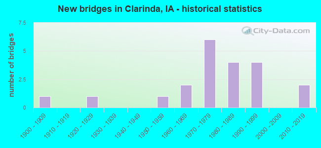
- New bridges - historical statistics
- 11900-1909
- 11920-1929
- 11950-1959
- 21960-1969
- 61970-1979
- 41980-1989
- 41990-1999
- 22010-2019

- Reconstructed bridges - Historical Statistics
- 11960-1969
- 01970-1979
- 11980-1989


- Bridge Condition - Deck
- 5.9%Very good
- 11.8%Good
- 23.5%Satisfactory
- 23.5%Fair
- 23.5%Poor
- 11.8%Failed

- Bridge Condition - Superstructure
- 17.6%Very good
- 5.9%Good
- 35.3%Satisfactory
- 29.4%Fair
- 11.8%Failed

- Bridge Condition - Substructure
- 5.9%Very good
- 23.5%Good
- 11.8%Satisfactory
- 17.6%Fair
- 23.5%Poor
- 5.9%Serious
- 11.8%Failed

- Bridge Condition - Channel
- 4.8%Very good
- 23.8%Good
- 42.9%Satisfactory
- 28.6%Fair

- Bridge Condition - Culverts
- 50.0%Good
- 50.0%Satisfactory
Find on map >> Show street view
Structure Number: 38691, Location: 0.3 MI. S OF N JCT. 2 (Lat: 40.732364, Lng: -95.012808), Route carried "on" structure: US 71, Year Built: 1972, Status: Open, Structure Length: 10.24m (33.60ft), Average Daily Traffic: 3,050 (year 2020), Truck Traffic: 11%, Average Future Daily Traffic: 3,050 (year 2040), Design Load: HS 20, Features Intersected: WEST NODAWAY RIVER
Minimum Vertical Clearance: 30+ m (98+ ft), Kilometerpoint: 19.063, Lanes on structure: 2, Base Highway Network: Yes, Owner: State Highway Agency, Approaching Roadway Width: 13.4m (44.0ft), Skew: 2 degrees, Material/Design: Steel continuous, Design/Construction: Stringer/Multi-beam, Number Of Spans In Main Unit: 3, Length of Maximum Span: 29.3m (96.1ft), Curb-To-Curb Width: 13.4m (44.0ft), Out-to-Out Width: 14.4m (47.2ft)
Condition: Deck: Fair, Superstructure: Satisfactory, Substructure: Fair, Channel: Satisfactory, Operating Rating: 60.2 metric tons, Method Used To Determine Operating Rating: Load Factor (LF), Inventory Rating: 36.1 metric tons, Method Used To Determine Inventory Rating: Load Factor (LF), Structural Evaluation: Somewhat better than minimum adequacy, Deck Geometry: Better than present minimum criteria, Waterway Adequacy: Equal to present minimum criteria, Approach Roadway Alignment: Equal to present minimum criteria, Designated Inspection Frequency: Every 24 months, Inspection Date: April 2020, Deck Structure Type: Concrete Cast-file-Place, Wearing Surface/Protective System: Wearing Surface: Low Slump Concrete
Find on map >> Show street view
Structure Number: 38831, Location: 0.3 MI W OF SR N-14 (Lat: 40.727528, Lng: -94.980178), Route carried "on" structure: State highway 2, Year Built: 1975, Status: Open, Structure Length: 6.13m (20.11ft), Average Daily Traffic: 2,420 (year 2020), Truck Traffic: 7%, Average Future Daily Traffic: 2,420 (year 2041), Design Load: HS 20, Features Intersected: EAST NODAWAY RIVER
Minimum Vertical Clearance: 30+ m (98+ ft), Kilometerpoint: 80.487, Lanes on structure: 2, Base Highway Network: Yes, Owner: State Highway Agency, Approaching Roadway Width: 13.4m (44.0ft), Skew: 2 degrees, Material/Design: Prestressed concrete, Design/Construction: Stringer/Multi-beam, Number Of Spans In Main Unit: 3, Length of Maximum Span: 29.3m (96.1ft), Curb-To-Curb Width: 13.4m (44.0ft), Out-to-Out Width: 14.4m (47.2ft)
Condition: Deck: Satisfactory, Superstructure: Very good, Substructure: Good, Channel: Good, Operating Rating: 62.9 metric tons, Method Used To Determine Operating Rating: Allowable Stress (AS), Inventory Rating: 28.8 metric tons, Method Used To Determine Inventory Rating: Allowable Stress (AS), Structural Evaluation: Better than present minimum criteria, Deck Geometry: Better than present minimum criteria, Waterway Adequacy: Equal to present minimum criteria, Approach Roadway Alignment: Equal to present desirable criteria, Designated Inspection Frequency: Every 24 months, Inspection Date: September 2021, Deck Structure Type: Concrete Cast-file-Place, Wearing Surface/Protective System: Wearing Surface: Low Slump Concrete
Find on map >> Show street view
Structure Number: 265281, Location: 068361502 (Lat: 40.700186, Lng: -94.970553), Route carried "on" structure: County highway , Year Built: 2012, Status: Open, Structure Length: 0.73m (2.40ft), Average Daily Traffic: 270 (year 2016), Truck Traffic: 8%, Average Future Daily Traffic: 270 (year 2040), Features Intersected: STREAM, Facility Carried by Structure: N 14 (V AVE)
Minimum Vertical Clearance: 30+ m (98+ ft), Kilometerpoint: 9.814, Lanes on structure: 2, Owner: County Highway Agency, Approaching Roadway Width: 7.9m (25.9ft), Skew: 3 degrees, Material/Design: Concrete continuous, Design/Construction: Culvert, Number Of Spans In Main Unit: 2, Length of Maximum Span: 3.7m (12.1ft)
Condition: Channel: Good, Culverts: Good, Operating Rating: 44.1 metric tons, Method Used To Determine Operating Rating: Field evaluation and documented engineering judgment, Inventory Rating: 32.7 metric tons, Method Used To Determine Inventory Rating: Field evaluation and documented engineering judgment, Structural Evaluation: Better than present minimum criteria, Waterway Adequacy: Equal to present desirable criteria, Approach Roadway Alignment: Equal to present desirable criteria, Designated Inspection Frequency: Every 24 months, Inspection Date: November 2020
Find on map >> Show street view
Structure Number: 26533, Location: 068362103 (Lat: 40.694731, Lng: -94.979544), Route carried "on" structure: County highway , Year Built: 1974, Status: Posted for load, Structure Length: 2.16m (7.09ft), Average Daily Traffic: 10 (year 2016), Average Future Daily Traffic: 10 (year 2040), Features Intersected: STREAM, Facility Carried by Structure: 240TH STREET
Minimum Vertical Clearance: 30+ m (98+ ft), Kilometerpoint: 14.875, Lanes on structure: 2, Owner: County Highway Agency, Approaching Roadway Width: 7.0m (23.0ft), Skew: 3 degrees, Material/Design: Wood or Timber, Design/Construction: Stringer/Multi-beam, Number Of Spans In Main Unit: 3, Length of Maximum Span: 7.3m (24.0ft), Curb-To-Curb Width: 6.1m (20.0ft), Out-to-Out Width: 6.1m (20.0ft)
Condition: Deck: Fair, Superstructure: Fair, Substructure: Poor, Channel: Fair, Operating Rating: 27.8 metric tons, Method Used To Determine Operating Rating: Allowable Stress (AS), Inventory Rating: 20.0 metric tons, Method Used To Determine Inventory Rating: Allowable Stress (AS), Structural Evaluation: Meets minimum limits, Deck Geometry: Somewhat better than minimum adequacy, Waterway Adequacy: Better than present minimum criteria, Approach Roadway Alignment: Equal to present minimum criteria, Bridge Posting: Required (Relationship of Operating Rating to Maximum Legal Load: 0.1 - 9.9% below), Length Of Structure Improvement: 9.00m (29.53ft), Designated Inspection Frequency: Every 24 months, Inspection Date: November 2020, Bridge Improvement Cost: $180,000, Roadway Improvement Cost: $20,000, Deck Structure Type: Wood or Timber, Wearing Surface/Protective System: Wearing Surface: Wood or Timber
Find on map >> Show street view
Structure Number: 265341, Location: 068362104 (Lat: 40.689058, Lng: -94.980156), Route carried "on" structure: County highway , Year Built: 1986, Status: Closed, Structure Length: 1.92m (6.30ft), Average Daily Traffic: 15 (year 2016), Average Future Daily Traffic: 15 (year 2040), Features Intersected: STREAM, Facility Carried by Structure: UPLAND AVENUE
Minimum Vertical Clearance: 30+ m (98+ ft), Kilometerpoint: 4.147, Lanes on structure: 2, Owner: County Highway Agency, Approaching Roadway Width: 6.1m (20.0ft), Material/Design: Wood or Timber, Design/Construction: Stringer/Multi-beam, Number Of Spans In Main Unit: 3, Length of Maximum Span: 8.8m (28.9ft), Curb-To-Curb Width: 5.4m (17.7ft), Out-to-Out Width: 5.5m (18.0ft)
Condition: Deck: Failed, Superstructure: Failed, Substructure: Failed, Channel: Fair, Deck Geometry: High priority of corrective action, Waterway Adequacy: Equal to present minimum criteria, Approach Roadway Alignment: Equal to present minimum criteria, Bridge Posting: Required (Relationship of Operating Rating to Maximum Legal Load: > 39.9% below), Length Of Structure Improvement: 8.50m (27.89ft), Designated Inspection Frequency: Every 24 months, Inspection Date: November 2020, Bridge Improvement Cost: $170,000, Roadway Improvement Cost: $20,000, Deck Structure Type: Wood or Timber, Wearing Surface/Protective System: Wearing Surface: Wood or Timber
Find on map >> Show street view
Structure Number: 265566, Location: 068371204 (Lat: 40.723169, Lng: -95.047586), Route carried "on" structure: County highway , Year Built: 1980, Status: Posted for load-capacity, Structure Length: 2.38m (7.81ft), Average Daily Traffic: 25 (year 2016), Average Future Daily Traffic: 25 (year 2040), Features Intersected: STREAM, Facility Carried by Structure: R AVENUE
Minimum Vertical Clearance: 30+ m (98+ ft), Kilometerpoint: 6.307, Lanes on structure: 2, Owner: County Highway Agency, Approaching Roadway Width: 6.7m (22.0ft), Material/Design: Steel, Design/Construction: Stringer/Multi-beam, Number Of Spans In Main Unit: 3, Length of Maximum Span: 7.9m (25.9ft), Curb-To-Curb Width: 5.8m (19.0ft), Out-to-Out Width: 5.8m (19.0ft)
Condition: Deck: Poor, Superstructure: Fair, Substructure: Poor, Channel: Fair, Operating Rating: 26.9 metric tons, Method Used To Determine Operating Rating: Allowable Stress (AS), Inventory Rating: 21.7 metric tons, Method Used To Determine Inventory Rating: Allowable Stress (AS), Structural Evaluation: Meets minimum limits, Deck Geometry: Meets minimum limits, Waterway Adequacy: Equal to present minimum criteria, Approach Roadway Alignment: Equal to present minimum criteria, Bridge Posting: Required (Relationship of Operating Rating to Maximum Legal Load: 10.0 - 19.9% below), Length Of Structure Improvement: 10.00m (32.81ft), Designated Inspection Frequency: Every 24 months, Inspection Date: November 2020, Bridge Improvement Cost: $200,000, Roadway Improvement Cost: $20,000, Deck Structure Type: Wood or Timber, Wearing Surface/Protective System: Wearing Surface: Bituminous
Find on map >> Show street view
Structure Number: 265571, Location: 068371303 (Lat: 40.710103, Lng: -95.029214), Route carried "on" structure: County highway , Year Built: 1999, Status: Open, Structure Length: 2.07m (6.79ft), Average Daily Traffic: 5 (year 2016), Average Future Daily Traffic: 5 (year 2040), Design Load: HS 20, Features Intersected: SOUTH BRANCH, Facility Carried by Structure: 230TH STREET
Minimum Vertical Clearance: 30+ m (98+ ft), Kilometerpoint: 27.883, Lanes on structure: 2, Owner: County Highway Agency, Approaching Roadway Width: 8.5m (27.9ft), Material/Design: Prestressed concrete, Design/Construction: Tee Beam, Number Of Spans In Main Unit: 3, Length of Maximum Span: 8.5m (27.9ft), Curb-To-Curb Width: 7.5m (24.6ft), Out-to-Out Width: 7.6m (24.9ft)
Condition: Deck: Fair, Superstructure: Fair, Substructure: Good, Channel: Satisfactory, Operating Rating: 32.7 metric tons, Method Used To Determine Operating Rating: Field evaluation and documented engineering judgment, Inventory Rating: 20.4 metric tons, Method Used To Determine Inventory Rating: Field evaluation and documented engineering judgment, Structural Evaluation: Somewhat better than minimum adequacy, Deck Geometry: Equal to present minimum criteria, Waterway Adequacy: Equal to present minimum criteria, Approach Roadway Alignment: Equal to present minimum criteria, Designated Inspection Frequency: Every 24 months, Inspection Date: November 2020, Deck Structure Type: Concrete Cast-file-Place, Wearing Surface/Protective System: Wearing Surface: Monolithic Concrete
Find on map >> Show street view
Structure Number: 26632, Location: 069361604 (Lat: 40.774692, Lng: -95.004447), Route carried "on" structure: County highway , Year Built: 1976, Status: Closed, Structure Length: 2.41m (7.91ft), Average Daily Traffic: 50 (year 2016), Average Future Daily Traffic: 50 (year 2041), Features Intersected: STREAM, Facility Carried by Structure: T AVENUE
Minimum Vertical Clearance: 30+ m (98+ ft), Kilometerpoint: 13.409, Lanes on structure: 2, Owner: County Highway Agency, Approaching Roadway Width: 7.6m (24.9ft), Material/Design: Steel, Design/Construction: Stringer/Multi-beam, Number Of Spans In Main Unit: 1, Number Of Approach Spans: 2, Length of Maximum Span: 12.2m (40.0ft), Curb-To-Curb Width: 5.5m (18.0ft), Out-to-Out Width: 5.5m (18.0ft)
Condition: Deck: Failed, Superstructure: Failed, Substructure: Failed, Channel: Fair, Deck Geometry: Meets minimum limits, Waterway Adequacy: Better than present minimum criteria, Approach Roadway Alignment: Equal to present minimum criteria, Bridge Posting: Required (Relationship of Operating Rating to Maximum Legal Load: > 39.9% below), Length Of Structure Improvement: 10.00m (32.81ft), Designated Inspection Frequency: Every 24 months, Inspection Date: November 2021, Bridge Improvement Cost: $200,000, Roadway Improvement Cost: $20,000, Deck Structure Type: Wood or Timber, Wearing Surface/Protective System: Wearing Surface: Wood or Timber
Find on map >> Show street view
Structure Number: 26635, Location: 069361806 (Lat: 40.779908, Lng: -95.033108), Route carried "on" structure: County highway , Year Built: 1962, Status: Open, Structure Length: 4.79m (15.72ft), Average Daily Traffic: 680 (year 2016), Truck Traffic: 15%, Average Future Daily Traffic: 680 (year 2041), Design Load: H 20, Features Intersected: NEELY BRANCH, Facility Carried by Structure: M-70/REDWOOD
Minimum Vertical Clearance: 30+ m (98+ ft), Kilometerpoint: 1.773, Lanes on structure: 2, Owner: County Highway Agency, Approaching Roadway Width: 12.2m (40.0ft), Material/Design: Steel, Design/Construction: Stringer/Multi-beam, Number Of Spans In Main Unit: 3, Length of Maximum Span: 20.7m (67.9ft), Curb-To-Curb Width: 8.6m (28.2ft), Out-to-Out Width: 9.2m (30.2ft)
Condition: Deck: Poor, Superstructure: Satisfactory, Substructure: Serious, Channel: Fair, Operating Rating: 38.1 metric tons, Method Used To Determine Operating Rating: Allowable Stress (AS), Inventory Rating: 26.0 metric tons, Method Used To Determine Inventory Rating: Allowable Stress (AS), Structural Evaluation: High priority of corrective action, Deck Geometry: Somewhat better than minimum adequacy, Waterway Adequacy: Better than present minimum criteria, Approach Roadway Alignment: Equal to present desirable criteria, Length Of Structure Improvement: 18.00m (59.06ft), Designated Inspection Frequency: Every 12 months, Inspection Date: November 2021, Bridge Improvement Cost: $360,000, Roadway Improvement Cost: $35,000, Deck Structure Type: Concrete Cast-file-Place, Wearing Surface/Protective System: Wearing Surface: Monolithic Concrete
Find on map >> Show street view
Structure Number: 266501, Location: C91100615 (Lat: 40.747817, Lng: -95.018264), Route carried "on" structure: City street , Year Built: 1984, Status: Open, Structure Length: 2.29m (7.51ft), Average Daily Traffic: 30 (year 2000), Average Future Daily Traffic: 30 (year 2040), Design Load: HS 20, Features Intersected: STREAM, Facility Carried by Structure: N 1ST ST
Minimum Vertical Clearance: 30+ m (98+ ft), Kilometerpoint: 0.951, Lanes on structure: 2, Owner: City or Municipal Highway Agency, Approaching Roadway Width: 9.1m (29.9ft), Material/Design: Concrete continuous, Design/Construction: Slab, Number Of Spans In Main Unit: 1, Length of Maximum Span: 8.8m (28.9ft), Curb-To-Curb Width: 9.1m (29.9ft), Out-to-Out Width: 10.1m (33.1ft)
Condition: Deck: Good, Superstructure: Good, Substructure: Satisfactory, Channel: Satisfactory, Operating Rating: 53.1 metric tons, Method Used To Determine Operating Rating: Allowable Stress (AS), Inventory Rating: 31.1 metric tons, Method Used To Determine Inventory Rating: Allowable Stress (AS), Structural Evaluation: Equal to present minimum criteria, Deck Geometry: Better than present minimum criteria, Waterway Adequacy: Better than present minimum criteria, Approach Roadway Alignment: Better than present minimum criteria, Designated Inspection Frequency: Every 24 months, Inspection Date: June 2020, Deck Structure Type: Concrete Cast-file-Place, Wearing Surface/Protective System: Wearing Surface: Monolithic Concrete
Find on map >> Show street view
Structure Number: 266541, Location: 069363501 (Lat: 40.742011, Lng: -94.966494), Route carried "on" structure: County highway , Year Built: 1993, Status: Open, Structure Length: 7.50m (24.61ft), Average Daily Traffic: 100 (year 2016), Average Future Daily Traffic: 100 (year 2039), Design Load: HS 20, Features Intersected: EAST NODAWAY RIVER, Facility Carried by Structure: J-35 / 210 ST
Minimum Vertical Clearance: 30+ m (98+ ft), Kilometerpoint: 4.851, Lanes on structure: 2, Owner: County Highway Agency, Approaching Roadway Width: 8.5m (27.9ft), Skew: 3 degrees, Material/Design: Prestressed concrete, Design/Construction: Stringer/Multi-beam, Number Of Spans In Main Unit: 3, Length of Maximum Span: 24.4m (80.1ft), Curb-To-Curb Width: 7.4m (24.3ft), Out-to-Out Width: 8.4m (27.6ft)
Condition: Deck: Good, Superstructure: Very good, Substructure: Good, Channel: Satisfactory, Operating Rating: 82.6 metric tons, Method Used To Determine Operating Rating: Load Factor (LF), Inventory Rating: 33.7 metric tons, Method Used To Determine Inventory Rating: Load Factor (LF), Structural Evaluation: Better than present minimum criteria, Deck Geometry: Equal to present minimum criteria, Waterway Adequacy: Better than present minimum criteria, Approach Roadway Alignment: Equal to present desirable criteria, Designated Inspection Frequency: Every 48 months, Inspection Date: January 2019, Deck Structure Type: Concrete Cast-file-Place, Wearing Surface/Protective System: Wearing Surface: Monolithic Concrete
Find on map >> Show street view
Structure Number: 266551, Location: 069363504 (Lat: 40.732497, Lng: -94.961339), Route carried "on" structure: County highway , Year Built: 1982, Status: Open, Structure Length: 3.87m (12.70ft), Average Daily Traffic: 40 (year 2016), Average Future Daily Traffic: 40 (year 2040), Design Load: H 15, Features Intersected: STREAM, Facility Carried by Structure: V AVENUE
Minimum Vertical Clearance: 30+ m (98+ ft), Kilometerpoint: 13.707, Lanes on structure: 2, Owner: County Highway Agency, Approaching Roadway Width: 8.8m (28.9ft), Material/Design: Concrete continuous, Design/Construction: Slab, Number Of Spans In Main Unit: 3, Length of Maximum Span: 14.9m (48.9ft), Curb-To-Curb Width: 7.3m (24.0ft), Out-to-Out Width: 8.0m (26.2ft)
Condition: Deck: Satisfactory, Superstructure: Satisfactory, Substructure: Good, Channel: Satisfactory, Operating Rating: 37.2 metric tons, Method Used To Determine Operating Rating: Load Factor (LF), Inventory Rating: 22.3 metric tons, Method Used To Determine Inventory Rating: Load Factor (LF), Structural Evaluation: Equal to present minimum criteria, Deck Geometry: Equal to present minimum criteria, Waterway Adequacy: Better than present minimum criteria, Approach Roadway Alignment: Better than present minimum criteria, Length Of Structure Improvement: 16.00m (52.49ft), Designated Inspection Frequency: Every 24 months, Inspection Date: November 2020, Bridge Improvement Cost: $320,000, Roadway Improvement Cost: $30,000, Deck Structure Type: Concrete Cast-file-Place, Wearing Surface/Protective System: Wearing Surface: Monolithic Concrete
Find on map >> Show street view
Structure Number: 26667, Location: 069371203 (Lat: 40.800203, Lng: -95.045033), Route carried "on" structure: County highway , Year Built: 1957, Status: Posted for load-capacity, Structure Length: 2.87m (9.42ft), Average Daily Traffic: 45 (year 2016), Average Future Daily Traffic: 45 (year 2040), Design Load: H 15, Features Intersected: NEELY BRANCH, Facility Carried by Structure: 170TH STREET
Minimum Vertical Clearance: 30+ m (98+ ft), Kilometerpoint: 27.378, Lanes on structure: 2, Owner: County Highway Agency, Approaching Roadway Width: 7.6m (24.9ft), Material/Design: Concrete, Design/Construction: Channel Beam, Number Of Spans In Main Unit: 3, Length of Maximum Span: 9.4m (30.8ft), Curb-To-Curb Width: 6.4m (21.0ft), Out-to-Out Width: 7.0m (23.0ft)
Condition: Deck: Fair, Superstructure: Fair, Substructure: Fair, Channel: Good, Operating Rating: 35.6 metric tons, Method Used To Determine Operating Rating: Load Factor (LF), Inventory Rating: 21.3 metric tons, Method Used To Determine Inventory Rating: Load Factor (LF), Structural Evaluation: Somewhat better than minimum adequacy, Deck Geometry: Somewhat better than minimum adequacy, Waterway Adequacy: Better than present minimum criteria, Approach Roadway Alignment: Better than present minimum criteria, Bridge Posting: Required (Relationship of Operating Rating to Maximum Legal Load: 0.1 - 9.9% below), Length Of Structure Improvement: 12.00m (39.37ft), Designated Inspection Frequency: Every 24 months, Inspection Date: November 2020, Bridge Improvement Cost: $240,000, Roadway Improvement Cost: $20,000, Deck Structure Type: Concrete Precast Panels, Wearing Surface/Protective System: Wearing Surface: Monolithic Concrete
Find on map >> Show street view
Structure Number: 26669, Location: 069371204 (Lat: 40.796447, Lng: -95.051825), Route carried "on" structure: County highway , Year Built: 1977, Status: Open, Structure Length: 3.87m (12.70ft), Average Daily Traffic: 20 (year 2016), Average Future Daily Traffic: 20 (year 2040), Design Load: H 15, Features Intersected: STREAM, Facility Carried by Structure: QUINCE AVENUE
Minimum Vertical Clearance: 30+ m (98+ ft), Kilometerpoint: 8.417, Lanes on structure: 2, Owner: County Highway Agency, Approaching Roadway Width: 7.9m (25.9ft), Material/Design: Concrete continuous, Design/Construction: Slab, Number Of Spans In Main Unit: 3, Length of Maximum Span: 14.9m (48.9ft), Curb-To-Curb Width: 7.3m (24.0ft), Out-to-Out Width: 8.1m (26.6ft)
Condition: Deck: Satisfactory, Superstructure: Satisfactory, Substructure: Satisfactory, Channel: Satisfactory, Operating Rating: 37.2 metric tons, Method Used To Determine Operating Rating: Load Factor (LF), Inventory Rating: 22.3 metric tons, Method Used To Determine Inventory Rating: Load Factor (LF), Structural Evaluation: Equal to present minimum criteria, Deck Geometry: Equal to present minimum criteria, Waterway Adequacy: Better than present minimum criteria, Approach Roadway Alignment: Equal to present desirable criteria, Length Of Structure Improvement: 15.50m (50.85ft), Designated Inspection Frequency: Every 24 months, Inspection Date: November 2020, Bridge Improvement Cost: $310,000, Roadway Improvement Cost: $30,000, Deck Structure Type: Concrete Cast-file-Place, Wearing Surface/Protective System: Wearing Surface: Monolithic Concrete
Find on map >> Show street view
Structure Number: 2667, Location: 069372202 (Lat: 40.771186, Lng: -95.099314), Route carried "on" structure: County highway , Year Built: 1962, Status: Open, Structure Length: 3.23m (10.60ft), Average Daily Traffic: 840 (year 2016), Truck Traffic: 11%, Average Future Daily Traffic: 840 (year 2040), Design Load: H 20, Features Intersected: SNAKE CREEK, Facility Carried by Structure: M-63 / O AVE
Minimum Vertical Clearance: 30+ m (98+ ft), Kilometerpoint: 11.811, Lanes on structure: 2, Owner: County Highway Agency, Approaching Roadway Width: 11.0m (36.1ft), Skew: 3 degrees, Material/Design: Steel, Design/Construction: Stringer/Multi-beam, Number Of Spans In Main Unit: 3, Length of Maximum Span: 13.1m (43.0ft), Curb-To-Curb Width: 8.5m (27.9ft), Out-to-Out Width: 9.1m (29.9ft)
Condition: Deck: Poor, Superstructure: Satisfactory, Substructure: Poor, Channel: Fair, Operating Rating: 38.8 metric tons, Method Used To Determine Operating Rating: Allowable Stress (AS), Inventory Rating: 26.9 metric tons, Method Used To Determine Inventory Rating: Allowable Stress (AS), Structural Evaluation: Meets minimum limits, Deck Geometry: Somewhat better than minimum adequacy, Waterway Adequacy: Better than present minimum criteria, Approach Roadway Alignment: Better than present minimum criteria, Length Of Structure Improvement: 13.00m (42.65ft), Designated Inspection Frequency: Every 24 months, Inspection Date: November 2020, Bridge Improvement Cost: $260,000, Roadway Improvement Cost: $25,000, Deck Structure Type: Concrete Cast-file-Place, Wearing Surface/Protective System: Wearing Surface: Monolithic Concrete
Find on map >> Show street view
Structure Number: 36307, Location: 069361403 (Lat: 40.778247, Lng: -94.958092), Route carried "on" structure: ServiceCounty highway , Year Built: 1900, Year Reconstructed: 1989, Status: Posted for load, Structure Length: 0.73m (2.40ft), Average Daily Traffic: 10 (year 2016), Truck Traffic: 18%, Average Future Daily Traffic: 190 (year 2040), Features Intersected: STREAM (SDB), Facility Carried by Structure: FIELD ENTRANCE
Minimum Vertical Clearance: 30+ m (98+ ft), Kilometerpoint: 2.985, Lanes on structure: 2, Owner: County Highway Agency, Approaching Roadway Width: 6.7m (22.0ft), Material/Design: Wood or Timber, Design/Construction: Stringer/Multi-beam, Number Of Spans In Main Unit: 1, Length of Maximum Span: 7.0m (23.0ft), Curb-To-Curb Width: 4.9m (16.1ft), Out-to-Out Width: 4.9m (16.1ft)
Condition: Deck: Poor, Superstructure: Fair, Substructure: Poor, Channel: Satisfactory, Operating Rating: 33.2 metric tons, Method Used To Determine Operating Rating: Allowable Stress (AS), Inventory Rating: 26.9 metric tons, Method Used To Determine Inventory Rating: Allowable Stress (AS), Structural Evaluation: Meets minimum limits, Deck Geometry: High priority of corrective action, Waterway Adequacy: Equal to present minimum criteria, Approach Roadway Alignment: Equal to present minimum criteria, Bridge Posting: Required (Relationship of Operating Rating to Maximum Legal Load: 0.1 - 9.9% below), Length Of Structure Improvement: 4.00m (13.12ft), Designated Inspection Frequency: Every 24 months, Inspection Date: November 2020, Bridge Improvement Cost: $80,000, Roadway Improvement Cost: $10,000, Deck Structure Type: Wood or Timber, Wearing Surface/Protective System: Wearing Surface: Wood or Timber
Find on map >> Show street view
Structure Number: 363076, Location: 069371502 (Lat: 40.783697, Lng: -95.099411), Route carried "on" structure: ServiceCounty highway , Year Built: 1995, Status: Open, Structure Length: 0.70m (2.30ft), Average Daily Traffic: 10 (year 2016), Truck Traffic: 11%, Average Future Daily Traffic: 840 (year 2040), Features Intersected: STREAM (SDB), Facility Carried by Structure: FIELD ENT.
Minimum Vertical Clearance: 30+ m (98+ ft), Kilometerpoint: 13.200, Lanes on structure: 2, Owner: County Highway Agency, Approaching Roadway Width: 6.4m (21.0ft), Material/Design: Steel, Design/Construction: Culvert, Number Of Spans In Main Unit: 2, Length of Maximum Span: 2.7m (8.9ft)
Condition: Channel: Satisfactory, Culverts: Satisfactory, Operating Rating: 44.1 metric tons, Method Used To Determine Operating Rating: Field evaluation and documented engineering judgment, Inventory Rating: 32.7 metric tons, Method Used To Determine Inventory Rating: Field evaluation and documented engineering judgment, Structural Evaluation: Equal to present minimum criteria, Waterway Adequacy: Better than present minimum criteria, Approach Roadway Alignment: Equal to present minimum criteria, Designated Inspection Frequency: Every 24 months, Inspection Date: November 2020
Find on map >> Show street view
Structure Number: 36323, Location: 069362906 (Lat: 40.752633, Lng: -95.013619), Route carried "on" structure: County highway , Year Built: 1990, Status: Open, Structure Length: 0.67m (2.20ft), Average Daily Traffic: 40 (year 2016), Average Future Daily Traffic: 40 (year 2039), Design Load: HS 20, Features Intersected: STREAM, Facility Carried by Structure: T AVENUE
Minimum Vertical Clearance: 30+ m (98+ ft), Kilometerpoint: 10.422, Lanes on structure: 2, Owner: County Highway Agency, Approaching Roadway Width: 8.5m (27.9ft), Skew: 1 degrees, Material/Design: Concrete continuous, Design/Construction: Culvert, Number Of Spans In Main Unit: 2, Length of Maximum Span: 3.0m (9.8ft)
Condition: Channel: Good, Culverts: Good, Operating Rating: 44.1 metric tons, Method Used To Determine Operating Rating: Assigned rating based on Load Factor Design (LFD) reported in metric tons, Inventory Rating: 32.7 metric tons, Method Used To Determine Inventory Rating: Assigned rating based on Load Factor Design (LFD) reported in metric tons, Structural Evaluation: Better than present minimum criteria, Waterway Adequacy: Better than present minimum criteria, Approach Roadway Alignment: Equal to present minimum criteria, Designated Inspection Frequency: Every 48 months, Inspection Date: January 2019
Find on map >> Show street view
Structure Number: 60211, Location: 2.1 MI S OF S JCT IOWA 2 (Lat: 40.696919, Lng: -95.038711), Route carried "on" structure: US 71, Year Built: 1924, Year Reconstructed: 1973, Status: Open, Structure Length: 0.76m (2.49ft), Average Daily Traffic: 2,710 (year 2020), Truck Traffic: 12%, Average Future Daily Traffic: 2,710 (year 2041), Design Load: HS 20, Features Intersected: STREAM
Minimum Vertical Clearance: 30+ m (98+ ft), Kilometerpoint: 13.568, Lanes on structure: 2, Base Highway Network: Yes, Owner: State Highway Agency, Approaching Roadway Width: 13.4m (44.0ft), Material/Design: Concrete continuous, Design/Construction: Culvert, Number Of Spans In Main Unit: 2, Length of Maximum Span: 3.7m (12.1ft)
Condition: Channel: Satisfactory, Culverts: Satisfactory, Operating Rating: 44.0 metric tons, Method Used To Determine Operating Rating: Field evaluation and documented engineering judgment, Inventory Rating: 32.3 metric tons, Method Used To Determine Inventory Rating: Field evaluation and documented engineering judgment, Structural Evaluation: Equal to present minimum criteria, Waterway Adequacy: Equal to present minimum criteria, Approach Roadway Alignment: Equal to present desirable criteria, Designated Inspection Frequency: Every 24 months, Inspection Date: November 2021
Find on map >> Show street view
Structure Number: 60212, Location: 0.6 mi. S OF S JCT. IA 2 (Lat: 40.717756, Lng: -95.038117), Route carried "on" structure: US 71, Year Built: 1972, Status: Open, Structure Length: 3.75m (12.30ft), Average Daily Traffic: 3,070 (year 2020), Truck Traffic: 13%, Average Future Daily Traffic: 3,070 (year 2041), Design Load: HS 20, Features Intersected: STREAM
Minimum Vertical Clearance: 30+ m (98+ ft), Kilometerpoint: 15.883, Lanes on structure: 2, Base Highway Network: Yes, Owner: State Highway Agency, Approaching Roadway Width: 13.4m (44.0ft), Material/Design: Concrete continuous, Design/Construction: Slab, Number Of Spans In Main Unit: 3, Length of Maximum Span: 14.3m (46.9ft), Curb-To-Curb Width: 13.4m (44.0ft), Out-to-Out Width: 14.4m (47.2ft)
Condition: Deck: Satisfactory, Superstructure: Satisfactory, Substructure: Fair, Channel: Good, Operating Rating: 61.9 metric tons, Method Used To Determine Operating Rating: Allowable Stress (AS), Inventory Rating: 32.3 metric tons, Method Used To Determine Inventory Rating: Allowable Stress (AS), Structural Evaluation: Somewhat better than minimum adequacy, Deck Geometry: Better than present minimum criteria, Waterway Adequacy: Equal to present minimum criteria, Approach Roadway Alignment: Equal to present desirable criteria, Designated Inspection Frequency: Every 24 months, Inspection Date: Febuary 2021, Deck Structure Type: Concrete Cast-file-Place, Wearing Surface/Protective System: Wearing Surface: Low Slump Concrete
Find on map >> Show street view
Structure Number: 603571, Location: 069363205 (Lat: 40.739267, Lng: -95.013622), Route carried "on" structure: City street , Year Built: 2018, Status: Open, Structure Length: 12.71m (41.70ft), Average Daily Traffic: 2,220 (year 2016), Average Future Daily Traffic: 2,220 (year 2040), Design Load: HL 93, Features Intersected: W NODAWAY RIVER, Facility Carried by Structure: EAST WASHINGTON ST
Minimum Vertical Clearance: 30+ m (98+ ft), Kilometerpoint: 2.045, Lanes on structure: 2, Owner: City or Municipal Highway Agency, Maintenance Responsibility: County Highway Agency, Approaching Roadway Width: 13.4m (44.0ft), Skew: 1 degrees, Material/Design: Prestressed concrete, Design/Construction: Stringer/Multi-beam, Number Of Spans In Main Unit: 3, Length of Maximum Span: 46.3m (151.9ft), Curb or Sidewalk Widths: Left: 0.4m (1.3ft), Right: 0.4m (1.3ft), Curb-To-Curb Width: 12.2m (40.0ft), Out-to-Out Width: 13.0m (42.7ft)
Condition: Deck: Very good, Superstructure: Very good, Substructure: Very good, Channel: Very good, Operating Rating: 42.1 metric tons, Method Used To Determine Operating Rating: Assigned ratings based on Load and Resistance Factor Design (LRFD) reported by rating factor (RF) using HL93 loadings, Inventory Rating: 32.4 metric tons, Method Used To Determine Inventory Rating: Assigned ratings based on Load and Resistance Factor Design (LRFD) reported by rating factor (RF) using HL93 loadings, Structural Evaluation: Equal to present desirable criteria, Deck Geometry: Equal to present minimum criteria, Waterway Adequacy: Equal to present desirable criteria, Approach Roadway Alignment: Equal to present desirable criteria, Designated Inspection Frequency: Every 24 months, Inspection Date: November 2020, Deck Structure Type: Concrete Cast-file-Place, Wearing Surface/Protective System: Wearing Surface: Monolithic Concrete, Deck Protection: Epoxy Coated Reinforcing