Bridge Statistics for Clarington, Ohio (OH)
Condition, Traffic, Stress, Structural Evaluation, Project Costs
- National Bridge Inventory (NBI) Statistics
- 11Number of bridges
- 102ft / 31.0mTotal length
- 26,921Total average daily traffic
- 2,849Total average daily truck traffic
- 37,367Total future (year 2012) average daily traffic
- National Bridge Inventory (NBI) Registered Bridges for Clarington
- No street view available for this location
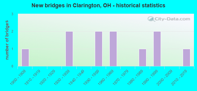
- New bridges - historical statistics
- 11900-1909
- 21930-1939
- 21950-1959
- 21960-1969
- 11980-1989
- 21990-1999
- 12010-2019

- Reconstructed bridges - Historical Statistics
- 21970-1979
- 01980-1989
- 01990-1999
- 12000-2009
- 12010-2019


- Bridge Condition - Deck
- 10.0%Very good
- 40.0%Good
- 40.0%Satisfactory
- 10.0%Fair

- Bridge Condition - Superstructure
- 10.0%Very good
- 30.0%Good
- 50.0%Satisfactory
- 10.0%Fair

- Bridge Condition - Substructure
- 20.0%Very good
- 40.0%Good
- 20.0%Satisfactory
- 20.0%Fair

- Bridge Condition - Channel
- 18.2%Very good
- 36.4%Good
- 27.3%Satisfactory
- 18.2%Poor
Find on map >> Show street view
Structure Number: 5600545, Location: 2.16M S OF JCT SR78 (Lat: 39.738489, Lng: -80.852311), Route carried "on" structure: State highway 7, Year Built: 1959, Year Reconstructed: 2017, Status: Open, Structure Length: 7.22m (23.69ft), Average Daily Traffic: 5,400 (year 2017), Truck Traffic: 7%, Average Future Daily Traffic: 7,495 (year 2037), Design Load: H 20, Features Intersected: OPOSSUM CREEK
Minimum Vertical Clearance: 30+ m (98+ ft), Kilometerpoint: 31.398, Lanes on structure: 2, Base Highway Network: Yes, Owner: State Highway Agency, Approaching Roadway Width: 10.4m (34.1ft), Skew: 2 degrees, Material/Design: Steel continuous, Design/Construction: Stringer/Multi-beam, Number Of Spans In Main Unit: 3, Length of Maximum Span: 27.4m (89.9ft), Curb-To-Curb Width: 10.4m (34.1ft), Out-to-Out Width: 10.4m (34.1ft)
Condition: Deck: Good, Superstructure: Satisfactory, Substructure: Very good, Channel: Good, Operating Rating: 42.1 metric tons, Method Used To Determine Operating Rating: Load Factor (LF) rating reported by rating factor (RF) method using MS18 loading, Inventory Rating: 38.9 metric tons, Method Used To Determine Inventory Rating: Load Factor (LF) rating reported by rating factor (RF) method using MS18 loading, Structural Evaluation: Equal to present minimum criteria, Deck Geometry: Meets minimum limits, Waterway Adequacy: Equal to present desirable criteria, Approach Roadway Alignment: Equal to present desirable criteria, Designated Inspection Frequency: Every 12 months, Underwater Inspection Frequency: Every 60 months, Inspection Date: September 2021, Underwater Inspection Date: July 2019, Deck Structure Type: Concrete Cast-file-Place, Wearing Surface/Protective System: Wearing Surface: Monolithic Concrete, Membrane: Epoxy, Deck Protection: Epoxy Coated Reinforcing
Find on map >> Show street view
Structure Number: 5600669, Location: 0.18M S OF JCT SR78 (Lat: 39.763000, Lng: -80.870789), Route carried "on" structure: State highway 7, Year Built: 1960, Status: Open, Structure Length: 9.42m (30.91ft), Average Daily Traffic: 5,164 (year 2015), Truck Traffic: 16%, Average Future Daily Traffic: 7,168 (year 2035), Design Load: H 20, Features Intersected: SUNFISH CREEK
Minimum Vertical Clearance: 30+ m (98+ ft), Kilometerpoint: 34.569, Lanes on structure: 4, Base Highway Network: Yes, Owner: State Highway Agency, Approaching Roadway Width: 19.5m (64.0ft), Skew: 14 degrees, Material/Design: Steel continuous, Design/Construction: Stringer/Multi-beam, Number Of Spans In Main Unit: 4, Length of Maximum Span: 25.9m (85.0ft), Curb or Sidewalk Widths: Left: 1.6m (5.2ft), Right: 1.0m (3.3ft), Curb-To-Curb Width: 21.3m (69.9ft), Out-to-Out Width: 23.9m (78.4ft)
Condition: Deck: Satisfactory, Superstructure: Satisfactory, Substructure: Satisfactory, Channel: Satisfactory, Operating Rating: 42.1 metric tons, Method Used To Determine Operating Rating: Allowable Stress (AS) rating reported by rating factor (RF) method using MS18 loading, Inventory Rating: 32.4 metric tons, Method Used To Determine Inventory Rating: Allowable Stress (AS) rating reported by rating factor (RF) method using MS18 loading, Structural Evaluation: Equal to present minimum criteria, Deck Geometry: Superior to present desirable criteria, Waterway Adequacy: Equal to present desirable criteria, Approach Roadway Alignment: Equal to present desirable criteria, Designated Inspection Frequency: Every 12 months, Underwater Inspection Frequency: Every 60 months, Inspection Date: September 2021, Underwater Inspection Date: July 2019, Deck Structure Type: Concrete Cast-file-Place, Wearing Surface/Protective System: Wearing Surface: Latex Concrete
Find on map >> Show street view
Structure Number: 5600723, Location: 1.45M N OF JCT SR78 (Lat: 39.782031, Lng: -80.855489), Route carried "on" structure: State highway 7, Year Built: 1960, Year Reconstructed: 2009, Status: Open, Structure Length: 4.10m (13.45ft), Average Daily Traffic: 4,265 (year 2015), Truck Traffic: 14%, Average Future Daily Traffic: 5,920 (year 2035), Design Load: H 20, Features Intersected: STILLHOUSE RUN
Minimum Vertical Clearance: 30+ m (98+ ft), Kilometerpoint: 37.176, Lanes on structure: 2, Base Highway Network: Yes, Owner: State Highway Agency, Approaching Roadway Width: 13.4m (44.0ft), Material/Design: Steel continuous, Design/Construction: Stringer/Multi-beam, Number Of Spans In Main Unit: 3, Length of Maximum Span: 15.2m (49.9ft), Curb-To-Curb Width: 13.4m (44.0ft), Out-to-Out Width: 13.4m (44.0ft)
Condition: Deck: Satisfactory, Superstructure: Good, Substructure: Good, Channel: Poor, Operating Rating: 42.1 metric tons, Method Used To Determine Operating Rating: Allowable Stress (AS) rating reported by rating factor (RF) method using MS18 loading, Inventory Rating: 32.4 metric tons, Method Used To Determine Inventory Rating: Allowable Stress (AS) rating reported by rating factor (RF) method using MS18 loading, Structural Evaluation: Better than present minimum criteria, Deck Geometry: Better than present minimum criteria, Waterway Adequacy: Equal to present desirable criteria, Approach Roadway Alignment: Equal to present desirable criteria, Designated Inspection Frequency: Every 12 months, Inspection Date: September 2021, Deck Structure Type: Concrete Cast-file-Place, Wearing Surface/Protective System: Wearing Surface: Integral Concrete
Find on map >> Show street view
Structure Number: 5600758, Location: 3.57M N OF JCT SR78 (Lat: 39.803800, Lng: -80.827789), Route carried "on" structure: State highway 7, Year Built: 1956, Status: Open, Structure Length: 0.88m (2.89ft), Average Daily Traffic: 4,474 (year 2015), Truck Traffic: 13%, Average Future Daily Traffic: 6,210 (year 2035), Design Load: H 15, Features Intersected: JOHNSON RUN
Minimum Vertical Clearance: 30+ m (98+ ft), Kilometerpoint: 40.588, Lanes on structure: 2, Base Highway Network: Yes, Owner: State Highway Agency, Approaching Roadway Width: 13.4m (44.0ft), Material/Design: Steel, Design/Construction: Culvert, Number Of Spans In Main Unit: 2, Length of Maximum Span: 3.7m (12.1ft)
Condition: Channel: Satisfactory, Culverts: Satisfactory, Operating Rating: 42.1 metric tons, Method Used To Determine Operating Rating: Load Factor (LF) rating reported by rating factor (RF) method using MS18 loading, Inventory Rating: 32.4 metric tons, Method Used To Determine Inventory Rating: Load Factor (LF) rating reported by rating factor (RF) method using MS18 loading, Structural Evaluation: Equal to present minimum criteria, Waterway Adequacy: Better than present minimum criteria, Approach Roadway Alignment: Equal to present desirable criteria, Designated Inspection Frequency: Every 12 months, Inspection Date: September 2021
Find on map >> Show street view
Structure Number: 5601835, Location: 2.92M W OF JCT SR7 (Lat: 39.756000, Lng: -80.912550), Route carried "on" structure: State highway 78, Year Built: 1932, Year Reconstructed: 1984, Status: Open, Structure Length: 0.79m (2.59ft), Average Daily Traffic: 2,085 (year 2015), Truck Traffic: 7%, Average Future Daily Traffic: 2,894 (year 2035), Design Load: HS 20, Features Intersected: STAUFFERS RUN
Minimum Vertical Clearance: 30+ m (98+ ft), Kilometerpoint: 47.218, Lanes on structure: 2, Base Highway Network: Yes, Owner: State Highway Agency, Approaching Roadway Width: 12.2m (40.0ft), Material/Design: Concrete, Design/Construction: Slab, Number Of Spans In Main Unit: 1, Length of Maximum Span: 7.3m (24.0ft), Curb or Sidewalk Widths: Left: 30.5m (100.1ft), Right: 30.5m (100.1ft), Curb-To-Curb Width: 12.2m (40.0ft), Out-to-Out Width: 12.2m (40.0ft)
Condition: Deck: Good, Superstructure: Good, Substructure: Good, Channel: Good, Operating Rating: 35.6 metric tons, Method Used To Determine Operating Rating: Load and Resistance Factor Rating (LRFR) rating reported by rating factor(RF) method using HL-93 loadings, Inventory Rating: 25.9 metric tons, Method Used To Determine Inventory Rating: Load and Resistance Factor Rating (LRFR) rating reported by rating factor(RF) method using HL-93 loadings, Structural Evaluation: Equal to present minimum criteria, Deck Geometry: Equal to present minimum criteria, Waterway Adequacy: Better than present minimum criteria, Approach Roadway Alignment: Equal to present desirable criteria, Designated Inspection Frequency: Every 24 months, Inspection Date: August 2021, Deck Structure Type: Concrete Cast-file-Place, Wearing Surface/Protective System: Wearing Surface: Bituminous
Find on map >> Show street view
Structure Number: 5601894, Location: 2.39M W OF JCT SR7 (Lat: 39.758469, Lng: -80.903150), Route carried "on" structure: State highway 78, Year Built: 1932, Year Reconstructed: 1984, Status: Open, Structure Length: 0.82m (2.69ft), Average Daily Traffic: 2,085 (year 2015), Truck Traffic: 7%, Average Future Daily Traffic: 2,894 (year 2035), Design Load: HS 20+Mod, Features Intersected: STREAM
Minimum Vertical Clearance: 30+ m (98+ ft), Kilometerpoint: 48.071, Lanes on structure: 2, Base Highway Network: Yes, Owner: State Highway Agency, Approaching Roadway Width: 12.2m (40.0ft), Material/Design: Prestressed concrete, Design/Construction: Box Beam or Girders - Multiple, Number Of Spans In Main Unit: 1, Length of Maximum Span: 7.9m (25.9ft), Curb-To-Curb Width: 12.2m (40.0ft), Out-to-Out Width: 12.2m (40.0ft)
Condition: Deck: Good, Superstructure: Good, Substructure: Fair, Channel: Good, Operating Rating: 42.1 metric tons, Method Used To Determine Operating Rating: Allowable Stress (AS) rating reported by rating factor (RF) method using MS18 loading, Inventory Rating: 32.4 metric tons, Method Used To Determine Inventory Rating: Allowable Stress (AS) rating reported by rating factor (RF) method using MS18 loading, Structural Evaluation: Somewhat better than minimum adequacy, Deck Geometry: Equal to present minimum criteria, Waterway Adequacy: Equal to present desirable criteria, Approach Roadway Alignment: Equal to present desirable criteria, Designated Inspection Frequency: Every 12 months, Inspection Date: August 2021, Deck Structure Type: Concrete Cast-file-Place, Wearing Surface/Protective System: Wearing Surface: Bituminous
Find on map >> Show street view
Structure Number: 5601932, Location: 1.5 MI W JCT SR 7 (Lat: 39.759019, Lng: -80.889061), Route carried "on" structure: State highway 78, Year Built: 1994, Status: Open, Structure Length: 2.41m (7.91ft), Average Daily Traffic: 2,085 (year 2015), Truck Traffic: 7%, Average Future Daily Traffic: 2,894 (year 2035), Design Load: HS 20+Mod, Features Intersected: SALEM RUN
Minimum Vertical Clearance: 30+ m (98+ ft), Kilometerpoint: 49.375, Lanes on structure: 2, Base Highway Network: Yes, Owner: State Highway Agency, Approaching Roadway Width: 12.2m (40.0ft), Skew: 4 degrees, Material/Design: Prestressed concrete, Design/Construction: Box Beam or Girders - Multiple, Number Of Spans In Main Unit: 1, Length of Maximum Span: 22.1m (72.5ft), Curb-To-Curb Width: 12.2m (40.0ft), Out-to-Out Width: 12.2m (40.0ft)
Condition: Deck: Satisfactory, Superstructure: Satisfactory, Substructure: Very good, Channel: Good, Operating Rating: 81.0 metric tons, Method Used To Determine Operating Rating: Load Factor (LF) rating reported by rating factor (RF) method using MS18 loading, Inventory Rating: 38.9 metric tons, Method Used To Determine Inventory Rating: Load Factor (LF) rating reported by rating factor (RF) method using MS18 loading, Structural Evaluation: Equal to present minimum criteria, Deck Geometry: Equal to present minimum criteria, Waterway Adequacy: Equal to present minimum criteria, Approach Roadway Alignment: Equal to present desirable criteria, Designated Inspection Frequency: Every 12 months, Inspection Date: August 2021, Deck Structure Type: Concrete Cast-file-Place, Wearing Surface/Protective System: Wearing Surface: Bituminous, Membrane: Preformed Fabric
Find on map >> Show street view
Structure Number: 5631114, Location: 0.06 MI. S. OF SR 78 (Lat: 39.764900, Lng: -80.932100), Route carried "on" structure: County highway T2214, Year Built: 1980, Status: Posted for load, Structure Length: 1.74m (5.71ft), Average Daily Traffic: 96 (year 2015), Truck Traffic: 7%, Average Future Daily Traffic: 133 (year 2035), Design Load: H 20, Features Intersected: SUNFISH CREEK, Facility Carried by Structure: SALEM TWP 2214
Minimum Vertical Clearance: 30+ m (98+ ft), Kilometerpoint: 0.097, Lanes on structure: 1, Owner: County Highway Agency, Approaching Roadway Width: 5.5m (18.0ft), Material/Design: Concrete continuous, Design/Construction: Slab, Number Of Spans In Main Unit: 3, Length of Maximum Span: 3.0m (9.8ft), Curb-To-Curb Width: 3.5m (11.5ft), Out-to-Out Width: 3.5m (11.5ft)
Condition: Deck: Satisfactory, Superstructure: Fair, Substructure: Fair, Channel: Satisfactory, Operating Rating: 13.6 metric tons, Method Used To Determine Operating Rating: Field evaluation and documented engineering judgment, Inventory Rating: 10.9 metric tons, Method Used To Determine Inventory Rating: Field evaluation and documented engineering judgment, Structural Evaluation: Meets minimum limits, Deck Geometry: High priority of corrective action, Waterway Adequacy: Meets minimum limits, Approach Roadway Alignment: Equal to present minimum criteria, Bridge Posting: Required (Relationship of Operating Rating to Maximum Legal Load: > 39.9% below), Designated Inspection Frequency: Every 12 months, Inspection Date: June 2021, Deck Structure Type: Concrete Cast-file-Place, Wearing Surface/Protective System: Wearing Surface: Monolithic Concrete
Find on map >> Show street view
Structure Number: 5632226, Location: 0.87 MI W. OF SR 7 (Lat: 39.727700, Lng: -80.857939), Route carried "on" structure: County highway C0026, Year Built: 1900, Status: Open, Structure Length: 0.82m (2.69ft), Average Daily Traffic: 167 (year 2015), Truck Traffic: 7%, Average Future Daily Traffic: 232 (year 2035), Design Load: HS 20, Features Intersected: GILMORE RUN, Facility Carried by Structure: BEAUTIFUL RIDGE RD
Minimum Vertical Clearance: 30+ m (98+ ft), Kilometerpoint: 9.656, Lanes on structure: 2, Owner: County Highway Agency, Approaching Roadway Width: 7.0m (23.0ft), Material/Design: Steel, Design/Construction: Stringer/Multi-beam, Number Of Spans In Main Unit: 1, Length of Maximum Span: 7.3m (24.0ft), Curb-To-Curb Width: 7.1m (23.3ft), Out-to-Out Width: 7.1m (23.3ft)
Condition: Deck: Fair, Superstructure: Satisfactory, Substructure: Satisfactory, Channel: Poor, Operating Rating: 97.2 metric tons, Method Used To Determine Operating Rating: Allowable Stress (AS) rating reported by rating factor (RF) method using MS18 loading, Inventory Rating: 68.0 metric tons, Method Used To Determine Inventory Rating: Allowable Stress (AS) rating reported by rating factor (RF) method using MS18 loading, Structural Evaluation: Equal to present minimum criteria, Deck Geometry: Meets minimum limits, Waterway Adequacy: Equal to present minimum criteria, Approach Roadway Alignment: Equal to present desirable criteria, Designated Inspection Frequency: Every 12 months, Inspection Date: June 2021, Deck Structure Type: Concrete Cast-file-Place, Wearing Surface/Protective System: Wearing Surface: Bituminous
Find on map >> Show street view
Structure Number: 5660017, Location: 0.51 MI N. JCT SR78 (Lat: 39.772961, Lng: -80.868481), Route carried "on" structure: City street MKT, Year Built: 1994, Status: Open, Structure Length: 1.43m (4.69ft), Average Daily Traffic: 900 (year 1992), Truck Traffic: 1%, Average Future Daily Traffic: 1,249 (year 2012), Features Intersected: GARDNER RUN, Facility Carried by Structure: MARKET STREET
Minimum Vertical Clearance: 30+ m (98+ ft), Kilometerpoint: 0.821, Lanes on structure: 2, Owner: City or Municipal Highway Agency, Approaching Roadway Width: 5.5m (18.0ft), Skew: 4 degrees, Material/Design: Steel, Design/Construction: Stringer/Multi-beam, Number Of Spans In Main Unit: 1, Length of Maximum Span: 13.4m (44.0ft), Curb or Sidewalk Widths: Left: 0.0m, Right: 1.2m (3.9ft), Curb-To-Curb Width: 7.3m (24.0ft), Out-to-Out Width: 7.3m (24.0ft)
Condition: Deck: Good, Superstructure: Satisfactory, Substructure: Good, Channel: Very good, Operating Rating: 61.6 metric tons, Method Used To Determine Operating Rating: Load Factor (LF) rating reported by rating factor (RF) method using MS18 loading, Inventory Rating: 35.6 metric tons, Method Used To Determine Inventory Rating: Load Factor (LF) rating reported by rating factor (RF) method using MS18 loading, Structural Evaluation: Equal to present minimum criteria, Deck Geometry: Meets minimum limits, Waterway Adequacy: Equal to present minimum criteria, Approach Roadway Alignment: Meets minimum limits, Designated Inspection Frequency: Every 12 months, Inspection Date: June 2021, Deck Structure Type: Corrugated Steel, Wearing Surface/Protective System: Wearing Surface: Bituminous
Find on map >> Show street view
Structure Number: 5660069, Location: 0.51 MI N OF JCT SR78 (Lat: 39.782961, Lng: -80.856850), Route carried "on" structure: City street MKT, Year Built: 2019, Status: Open, Structure Length: 1.34m (4.40ft), Average Daily Traffic: 200 (year 2019), Truck Traffic: 3%, Average Future Daily Traffic: 278 (year 2039), Design Load: HL 93, Features Intersected: STILL HOUSE RUN, Facility Carried by Structure: MARKET STREET
Minimum Vertical Clearance: 30+ m (98+ ft), Kilometerpoint: 0.821, Lanes on structure: 2, Owner: City or Municipal Highway Agency, Approaching Roadway Width: 6.1m (20.0ft), Material/Design: Prestressed concrete, Design/Construction: Box Beam or Girders - Multiple, Number Of Spans In Main Unit: 1, Length of Maximum Span: 12.4m (40.7ft), Curb-To-Curb Width: 9.8m (32.2ft), Out-to-Out Width: 9.8m (32.2ft)
Condition: Deck: Very good, Superstructure: Very good, Substructure: Good, Channel: Very good, Operating Rating: 71.3 metric tons, Method Used To Determine Operating Rating: Load and Resistance Factor Rating (LRFR) rating reported by rating factor(RF) method using HL-93 loadings, Inventory Rating: 55.1 metric tons, Method Used To Determine Inventory Rating: Load and Resistance Factor Rating (LRFR) rating reported by rating factor(RF) method using HL-93 loadings, Structural Evaluation: Better than present minimum criteria, Deck Geometry: Better than present minimum criteria, Waterway Adequacy: Equal to present minimum criteria, Approach Roadway Alignment: Equal to present minimum criteria, Length Of Structure Improvement: 1.34m (4.40ft), Designated Inspection Frequency: Every 12 months, Inspection Date: June 2021, Deck Structure Type: Other, Wearing Surface/Protective System: Wearing Surface: Bituminous