Bridge Statistics for Clark, New Jersey (NJ)
Condition, Traffic, Stress, Structural Evaluation, Project Costs
- National Bridge Inventory (NBI) Statistics
- 27Number of bridges
- 200ft / 60.5mTotal length
- $20,701,000Total costs
- 2,952,490Total average daily traffic
- 36,168Total average daily truck traffic
- National Bridge Inventory (NBI) Registered Bridges for Clark
- No street view available for this location
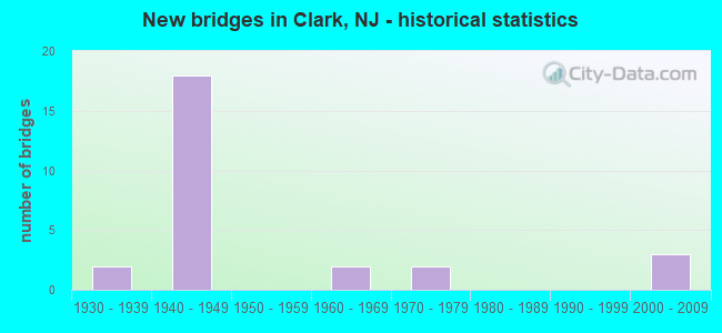
- New bridges - historical statistics
- 21930-1939
- 181940-1949
- 21960-1969
- 21970-1979
- 32000-2009
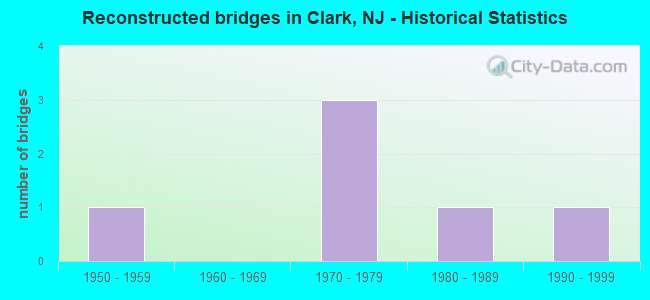
- Reconstructed bridges - Historical Statistics
- 11950-1959
- 01960-1969
- 31970-1979
- 11980-1989
- 11990-1999

- Bridge Condition - Deck
- 33.3%Good
- 44.4%Satisfactory
- 22.2%Fair
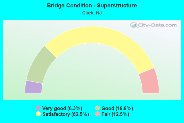
- Bridge Condition - Superstructure
- 6.3%Very good
- 18.8%Good
- 62.5%Satisfactory
- 12.5%Fair
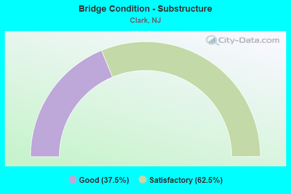
- Bridge Condition - Substructure
- 37.5%Good
- 62.5%Satisfactory
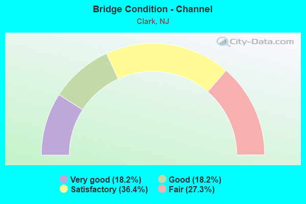
- Bridge Condition - Channel
- 18.2%Very good
- 18.2%Good
- 36.4%Satisfactory
- 27.3%Fair
Find on map >> Show street view
Structure Number: 2002005, Location: 0.85 MILES EAST OF CR 632 (Lat: 40.627619, Lng: -74.285319), Route carried "on" structure: City street , Year Built: 2003, Status: Open, Structure Length: 4.08m (13.39ft), Average Daily Traffic: 16,784 (year 2020), Truck Traffic: 4%, Average Future Daily Traffic: 20,481 (year 2040), Design Load: HS 25 or greater, Features Intersected: RAHWAY RIVER, Facility Carried by Structure: VALLEY ROAD
Minimum Vertical Clearance: 30+ m (98+ ft), Kilometerpoint: 1.368, Lanes on structure: 2, Owner: County Highway Agency, Approaching Roadway Width: 12.2m (40.0ft), Material/Design: Prestressed concrete, Design/Construction: Box Beam or Girders - Multiple, Number Of Spans In Main Unit: 3, Length of Maximum Span: 13.4m (44.0ft), Curb or Sidewalk Widths: Left: 2.0m (6.6ft), Right: 2.0m (6.6ft), Curb-To-Curb Width: 12.2m (40.0ft), Out-to-Out Width: 17.4m (57.1ft)
Condition: Deck: Good, Superstructure: Very good, Substructure: Good, Channel: Good, Inventory Rating: 59.0 metric tons, Method Used To Determine Inventory Rating: Load Factor (LF), Structural Evaluation: Better than present minimum criteria, Deck Geometry: Somewhat better than minimum adequacy, Waterway Adequacy: Equal to present minimum criteria, Approach Roadway Alignment: Meets minimum limits, Designated Inspection Frequency: Every 24 months, Inspection Date: Febuary 2020, Deck Structure Type: Concrete Cast-file-Place, Wearing Surface/Protective System: Wearing Surface: Epoxy Overlay, Deck Protection: Galvanized Reinforcing
Find on map >> Show street view
Structure Number: 2002012, Location: NEAR KINCAID PLACE (Lat: 40.609769, Lng: -74.339050), Route carried "on" structure: County highway 607, Year Built: 1971, Year Reconstructed: 1997, Status: Open, Structure Length: 1.16m (3.81ft), Average Daily Traffic: 20,033 (year 2020), Truck Traffic: 4%, Average Future Daily Traffic: 24,444 (year 2040), Design Load: HS 20+Mod, Features Intersected: STR 10-7-18 PUMP PATC BR, Facility Carried by Structure: OAK RIDGE ROAD
Minimum Vertical Clearance: 30+ m (98+ ft), Kilometerpoint: 0.692, Lanes on structure: 2, Owner: County Highway Agency, Approaching Roadway Width: 14.0m (45.9ft), Material/Design: Prestressed concrete, Design/Construction: Box Beam or Girders - Multiple, Number Of Spans In Main Unit: 1, Length of Maximum Span: 10.7m (35.1ft), Curb or Sidewalk Widths: Left: 1.4m (4.6ft), Right: 1.4m (4.6ft), Curb-To-Curb Width: 14.0m (45.9ft), Out-to-Out Width: 17.5m (57.4ft)
Condition: Deck: Fair, Superstructure: Satisfactory, Substructure: Good, Channel: Fair, Operating Rating: 65.3 metric tons, Method Used To Determine Operating Rating: Load Factor (LF), Inventory Rating: 39.0 metric tons, Method Used To Determine Inventory Rating: Load Factor (LF), Structural Evaluation: Equal to present minimum criteria, Deck Geometry: Superior to present desirable criteria, Waterway Adequacy: Equal to present desirable criteria, Approach Roadway Alignment: Equal to present desirable criteria, Designated Inspection Frequency: Every 24 months, Inspection Date: Febuary 2020, Deck Structure Type: Concrete Cast-file-Place, Wearing Surface/Protective System: Wearing Surface: Monolithic Concrete
Find on map >> Show street view
Structure Number: 2002019, Location: NEAR FEATHERBED LANE (Lat: 40.620911, Lng: -74.321381), Route carried "on" structure: County highway 607, Year Built: 2004, Status: Open, Structure Length: 3.20m (10.50ft), Average Daily Traffic: 22,765 (year 2020), Truck Traffic: 4%, Average Future Daily Traffic: 27,320 (year 2040), Design Load: HS 25 or greater, Features Intersected: RESERVOIR
Minimum Vertical Clearance: 30+ m (98+ ft), Kilometerpoint: 2.736, Lanes on structure: 2, Owner: County Highway Agency, Approaching Roadway Width: 14.0m (45.9ft), Material/Design: Prestressed concrete, Design/Construction: Box Beam or Girders - Multiple, Number Of Spans In Main Unit: 2, Length of Maximum Span: 14.9m (48.9ft), Curb or Sidewalk Widths: Left: 2.1m (6.9ft), Right: 2.1m (6.9ft), Curb-To-Curb Width: 14.0m (45.9ft), Out-to-Out Width: 19.3m (63.3ft)
Condition: Deck: Good, Superstructure: Satisfactory, Substructure: Good, Channel: Very good, Inventory Rating: 71.7 metric tons, Method Used To Determine Inventory Rating: Load Factor (LF), Structural Evaluation: Equal to present minimum criteria, Deck Geometry: Superior to present desirable criteria, Waterway Adequacy: Equal to present desirable criteria, Approach Roadway Alignment: Better than present minimum criteria, Designated Inspection Frequency: Every 24 months, Underwater Inspection Frequency: Every 48 months, Inspection Date: March 2020, Underwater Inspection Date: April 2020, Deck Structure Type: Concrete Precast Panels, Wearing Surface/Protective System: Wearing Surface: Epoxy Overlay, Deck Protection: Galvanized Reinforcing
Find on map >> Show street view
Structure Number: 2002027, Location: AT SCOTCH PLAINS LINE (Lat: 40.615369, Lng: -74.338981), Route carried "on" structure: City street , Year Built: 2004, Status: Open, Structure Length: 1.58m (5.18ft), Average Daily Traffic: 765 (year 2020), Truck Traffic: 1%, Average Future Daily Traffic: 933 (year 2040), Features Intersected: ROBINSONS BR RAHWAY RVR, Facility Carried by Structure: GOODMANS CROSSING
Minimum Vertical Clearance: 30+ m (98+ ft), Kilometerpoint: 0.000, Lanes on structure: 2, Owner: County Highway Agency, Approaching Roadway Width: 9.1m (29.9ft), Skew: 1 degrees, Material/Design: Prestressed concrete, Design/Construction: Box Beam or Girders - Multiple, Number Of Spans In Main Unit: 1, Length of Maximum Span: 14.3m (46.9ft), Curb or Sidewalk Widths: Left: 2.2m (7.2ft), Right: 2.2m (7.2ft), Curb-To-Curb Width: 9.1m (29.9ft), Out-to-Out Width: 14.8m (48.6ft)
Condition: Deck: Good, Superstructure: Good, Substructure: Satisfactory, Channel: Satisfactory, Inventory Rating: 66.2 metric tons, Method Used To Determine Inventory Rating: Load Factor (LF), Structural Evaluation: Equal to present minimum criteria, Deck Geometry: Equal to present minimum criteria, Waterway Adequacy: Better than present minimum criteria, Approach Roadway Alignment: Equal to present desirable criteria, Designated Inspection Frequency: Every 24 months, Inspection Date: Febuary 2020, Deck Structure Type: Concrete Cast-file-Place, Wearing Surface/Protective System: Wearing Surface: Other, Deck Protection: Epoxy Coated Reinforcing
Find on map >> Show street view
Structure Number: 2002036, Location: NEAR VICTORIA DRIVE (Lat: 40.622789, Lng: -74.324289), Route carried "on" structure: City street , Year Built: 1978, Status: Open, Structure Length: 3.84m (12.60ft), Average Daily Traffic: 6,181 (year 2020), Truck Traffic: 1%, Average Future Daily Traffic: 7,543 (year 2040), Design Load: HS 20+Mod, Features Intersected: MIDDLESEX RESERVOIR, Facility Carried by Structure: FEATHERBED LANE
Minimum Vertical Clearance: 30+ m (98+ ft), Kilometerpoint: 0.000, Lanes on structure: 2, Owner: County Highway Agency, Approaching Roadway Width: 9.1m (29.9ft), Material/Design: Prestressed concrete, Design/Construction: Box Beam or Girders - Multiple, Number Of Spans In Main Unit: 3, Length of Maximum Span: 14.0m (45.9ft), Curb or Sidewalk Widths: Left: 1.8m (5.9ft), Right: 1.8m (5.9ft), Curb-To-Curb Width: 9.1m (29.9ft), Out-to-Out Width: 13.5m (44.3ft)
Condition: Deck: Satisfactory, Superstructure: Good, Substructure: Satisfactory, Channel: Good, Operating Rating: 52.6 metric tons, Method Used To Determine Operating Rating: Load Factor (LF), Inventory Rating: 30.8 metric tons, Method Used To Determine Inventory Rating: Load Factor (LF), Structural Evaluation: Equal to present minimum criteria, Deck Geometry: High priority of corrective action, Waterway Adequacy: Equal to present desirable criteria, Approach Roadway Alignment: Equal to present minimum criteria, Length Of Structure Improvement: 3.84m (12.60ft), Designated Inspection Frequency: Every 24 months, Underwater Inspection Frequency: Every 48 months, Inspection Date: March 2020, Underwater Inspection Date: April 2020, Bridge Improvement Cost: $52,000, Roadway Improvement Cost: $25,000, Total Project Cost: $127,000 ( Estimate for 2020), Deck Structure Type: Concrete Cast-file-Place, Wearing Surface/Protective System: Wearing Surface: Monolithic Concrete, Deck Protection: Epoxy Coated Reinforcing
Find on map >> Show street view
Structure Number: 2002042, Location: NEAR ORCHARD STREET (Lat: 40.608200, Lng: -74.337181), Route carried "on" structure: City street , Year Built: 1965, Status: Open, Structure Length: 0.91m (2.99ft), Average Daily Traffic: 331 (year 2020), Truck Traffic: 1%, Average Future Daily Traffic: 408 (year 2040), Design Load: HS 20, Features Intersected: PUMPKIN PATCH BROOK, Facility Carried by Structure: BROOKSIDE TERRACE
Minimum Vertical Clearance: 30+ m (98+ ft), Kilometerpoint: 0.000, Lanes on structure: 2, Owner: County Highway Agency, Approaching Roadway Width: 9.1m (29.9ft), Material/Design: Concrete continuous, Design/Construction: Culvert, Number Of Spans In Main Unit: 2, Length of Maximum Span: 4.3m (14.1ft), Curb or Sidewalk Widths: Left: 2.5m (8.2ft), Right: 2.5m (8.2ft), Curb-To-Curb Width: 9.1m (29.9ft), Out-to-Out Width: 14.9m (48.9ft)
Condition: Channel: Fair, Culverts: Satisfactory, Operating Rating: 40.8 metric tons, Method Used To Determine Operating Rating: Load Factor (LF), Inventory Rating: 24.5 metric tons, Method Used To Determine Inventory Rating: Load Factor (LF), Structural Evaluation: Equal to present minimum criteria, Deck Geometry: Equal to present minimum criteria, Waterway Adequacy: Somewhat better than minimum adequacy, Approach Roadway Alignment: Better than present minimum criteria, Designated Inspection Frequency: Every 24 months, Inspection Date: Febuary 2020, Deck Structure Type: Concrete Precast Panels, Wearing Surface/Protective System: Wearing Surface: Bituminous
Find on map >> Show street view
Structure Number: 2002043, Location: NEAR ORCHARD TERRACE (Lat: 40.607369, Lng: -74.333639), Route carried "on" structure: City street , Year Built: 1965, Status: Open, Structure Length: 0.91m (2.99ft), Average Daily Traffic: 546 (year 2020), Truck Traffic: 1%, Average Future Daily Traffic: 668 (year 2040), Design Load: H 20, Features Intersected: PUMPKIN PATCH BROOK, Facility Carried by Structure: HAWTHORNE DRIVE
Minimum Vertical Clearance: 30+ m (98+ ft), Kilometerpoint: 0.000, Lanes on structure: 2, Owner: County Highway Agency, Approaching Roadway Width: 9.1m (29.9ft), Material/Design: Concrete continuous, Design/Construction: Culvert, Number Of Spans In Main Unit: 2, Length of Maximum Span: 4.6m (15.1ft), Curb or Sidewalk Widths: Left: 2.5m (8.2ft), Right: 2.5m (8.2ft), Curb-To-Curb Width: 9.1m (29.9ft), Out-to-Out Width: 14.9m (48.9ft)
Condition: Channel: Fair, Culverts: Satisfactory, Operating Rating: 38.1 metric tons, Method Used To Determine Operating Rating: Load Factor (LF), Inventory Rating: 22.7 metric tons, Method Used To Determine Inventory Rating: Load Factor (LF), Structural Evaluation: Equal to present minimum criteria, Deck Geometry: Equal to present minimum criteria, Waterway Adequacy: Equal to present desirable criteria, Approach Roadway Alignment: Better than present minimum criteria, Designated Inspection Frequency: Every 24 months, Inspection Date: Febuary 2020, Deck Structure Type: Concrete Precast Panels, Wearing Surface/Protective System: Wearing Surface: Bituminous
Find on map >> Show street view
Structure Number: 205316, Location: 0.48 mi north CR 607 (Lat: 40.616039, Lng: -74.338769), Route carried "on" structure: County highway 655, Year Built: 1936, Status: Open, Structure Length: 6.40m (21.00ft), Average Daily Traffic: 20,300 (year 2020), Truck Traffic: 4%, Average Future Daily Traffic: 24,770 (year 2040), Features Intersected: LV ML & Rahway Rv
Minimum Vertical Clearance: 30+ m (98+ ft), Kilometerpoint: 0.772, Lanes on structure: 2, Maintenance Responsibility: State Highway Agency, Approaching Roadway Width: 10.4m (34.1ft), Material/Design: Steel, Design/Construction: Stringer/Multi-beam, Number Of Spans In Main Unit: 4, Length of Maximum Span: 19.5m (64.0ft), Curb or Sidewalk Widths: Left: 1.8m (5.9ft), Right: 1.8m (5.9ft), Curb-To-Curb Width: 10.4m (34.1ft), Out-to-Out Width: 14.6m (47.9ft)
Condition: Deck: Fair, Superstructure: Satisfactory, Substructure: Satisfactory, Channel: Satisfactory, Operating Rating: 64.4 metric tons, Method Used To Determine Operating Rating: Load Factor (LF), Inventory Rating: 38.1 metric tons, Method Used To Determine Inventory Rating: Load Factor (LF), Structural Evaluation: Equal to present minimum criteria, Deck Geometry: Meets minimum limits, Underclear: Equal to present minimum criteria, Waterway Adequacy: Equal to present minimum criteria, Approach Roadway Alignment: Equal to present minimum criteria, Designated Inspection Frequency: Every 24 months, Inspection Date: November 2020, Deck Structure Type: Concrete Cast-file-Place, Wearing Surface/Protective System: Wearing Surface: Bituminous
Find on map >> Show street view
Structure Number: 2053161, Location: 0.7 MI NW OF GSP EXIT 135 (Lat: 40.633619, Lng: -74.315019), Route carried "on" structure: County highway 613, Year Built: 1934, Status: Open, Structure Length: 3.93m (12.89ft), Average Daily Traffic: 18,070 (year 2021), Truck Traffic: 4%, Average Future Daily Traffic: 22,049 (year 2041), Features Intersected: LEHIGH VALLEY MAIN LINE
Minimum Vertical Clearance: 30+ m (98+ ft), Kilometerpoint: 5.971, Lanes on structure: 2, Base Highway Network: Yes, Maintenance Responsibility: State Highway Agency, Approaching Roadway Width: 9.1m (29.9ft), Skew: 2 degrees, Material/Design: Steel, Design/Construction: Girder and Floorbeam System, Number Of Spans In Main Unit: 1, Number Of Approach Spans: 2, Length of Maximum Span: 19.2m (63.0ft), Curb or Sidewalk Widths: Left: 1.8m (5.9ft), Right: 1.8m (5.9ft), Curb-To-Curb Width: 9.1m (29.9ft), Out-to-Out Width: 9.8m (32.2ft)
Condition: Deck: Satisfactory, Superstructure: Fair, Substructure: Satisfactory, Operating Rating: 34.5 metric tons, Method Used To Determine Operating Rating: Load Factor (LF), Inventory Rating: 20.0 metric tons, Method Used To Determine Inventory Rating: Load Factor (LF), Structural Evaluation: Somewhat better than minimum adequacy, Deck Geometry: High priority of corrective action, Underclear: Somewhat better than minimum adequacy, Approach Roadway Alignment: Somewhat better than minimum adequacy, Length Of Structure Improvement: 4.88m (16.01ft), Designated Inspection Frequency: Every 24 months, Critical Feature Inspection Frequency: Every 24 months, Inspection Date: September 2021, Critical Feature Inspection Date: September 2021, Bridge Improvement Cost: $356,000, Roadway Improvement Cost: $356,000, Total Project Cost: $7,568,000 ( Estimate for 2019), Deck Structure Type: Concrete Cast-file-Place, Wearing Surface/Protective System: Wearing Surface: Bituminous, Membrane: Preformed Fabric
Find on map >> Show street view
Structure Number: 361350T, Location: 3.2 MI NORTH OF RT 27 (Lat: 40.612194, Lng: -74.311889), Route carried "on" structure: Other road GSP, Year Built: 1947, Year Reconstructed: 1977, Status: Open, Structure Length: 0.61m (2.00ft), Average Daily Traffic: 278,487 (year 2021), Truck Traffic: 1%, Average Future Daily Traffic: 339,807 (year 2041), Design Load: HS 20, Features Intersected: BR RAHWAY RIVER & MAINS
Minimum Vertical Clearance: 30+ m (98+ ft), Kilometerpoint: 217.261, Lanes on structure: 10, Base Highway Network: Yes, Toll: On toll road, Owner: State Toll Authority, Approaching Roadway Width: 47.5m (155.8ft), Skew: 30 degrees, Material/Design: Concrete, Design/Construction: Culvert, Number Of Spans In Main Unit: 2, Length of Maximum Span: 4.0m (13.1ft)
Condition: Channel: Satisfactory, Culverts: Satisfactory, Operating Rating: 96.9 metric tons, Method Used To Determine Operating Rating: Load and Resistance Factor Rating (LRFR) rating reported by rating factor(RF) method using HL-93 loadings, Inventory Rating: 96.9 metric tons, Method Used To Determine Inventory Rating: Load and Resistance Factor Rating (LRFR) rating reported by rating factor(RF) method using HL-93 loadings, Structural Evaluation: Equal to present minimum criteria, Waterway Adequacy: Equal to present desirable criteria, Approach Roadway Alignment: Equal to present desirable criteria, Designated Inspection Frequency: Every 24 months, Inspection Date: July 2021
Find on map >> Show street view
Structure Number: 361353T, Location: 3.5 MILE NORTH OF RT 27 (Lat: 40.615094, Lng: -74.311492), Route carried "on" structure: County highway 604, Year Built: 1948, Status: Open, Structure Length: 4.88m (16.01ft), Average Daily Traffic: 7,997 (year 2021), Truck Traffic: 4%, Average Future Daily Traffic: 9,758 (year 2041), Design Load: HS 20, Features Intersected: GARDEN STATE PARKWAY
Minimum Vertical Clearance: 30+ m (98+ ft), Kilometerpoint: 1.078, Lanes on structure: 2, Lanes under structure: 10, Owner: State Toll Authority, Approaching Roadway Width: 12.2m (40.0ft), Skew: 2 degrees, Material/Design: Concrete continuous, Design/Construction: Frame, Number Of Spans In Main Unit: 2, Length of Maximum Span: 22.6m (74.1ft), Curb or Sidewalk Widths: Left: 1.6m (5.2ft), Right: 1.6m (5.2ft), Curb-To-Curb Width: 12.7m (41.7ft), Out-to-Out Width: 16.8m (55.1ft)
Condition: Superstructure: Satisfactory, Substructure: Satisfactory, Operating Rating: 36.9 metric tons, Method Used To Determine Operating Rating: Load and Resistance Factor Rating (LRFR) rating reported by rating factor(RF) method using HL-93 loadings, Inventory Rating: 28.5 metric tons, Method Used To Determine Inventory Rating: Load and Resistance Factor Rating (LRFR) rating reported by rating factor(RF) method using HL-93 loadings, Structural Evaluation: Equal to present minimum criteria, Deck Geometry: Somewhat better than minimum adequacy, Underclear: High priority of corrective action, Approach Roadway Alignment: Equal to present desirable criteria, Length Of Structure Improvement: 4.88m (16.01ft), Designated Inspection Frequency: Every 24 months, Inspection Date: July 2021, Bridge Improvement Cost: $2,601,000, Roadway Improvement Cost: $260,000, Total Project Cost: $2,861,000 ( Estimate for 2017)
Find on map >> Show street view
Structure Number: 361356T, Location: 3.6 MILE NORTH OF RT 27 (Lat: 40.619369, Lng: -74.310250), Route carried "on" structure: Other road GSP, Year Built: 1948, Year Reconstructed: 1980, Status: Open, Structure Length: 2.29m (7.51ft), Average Daily Traffic: 247,435 (year 2021), Truck Traffic: 1%, Average Future Daily Traffic: 301,918 (year 2041), Design Load: HS 20, Features Intersected: MIDDLESEX RESERVOIR, Facility Carried by Structure: GARDEN ST PARKWAY
Minimum Vertical Clearance: 30+ m (98+ ft), Kilometerpoint: 218.275, Lanes on structure: 10, Base Highway Network: Yes, Toll: On toll road, Owner: State Toll Authority, Approaching Roadway Width: 41.5m (136.2ft), Skew: 30 degrees, Material/Design: Steel, Design/Construction: Stringer/Multi-beam, Number Of Spans In Main Unit: 1, Length of Maximum Span: 21.6m (70.9ft), Curb or Sidewalk Widths: Left: 0.2m (0.7ft), Right: 1.6m (5.2ft), Curb-To-Curb Width: 41.7m (136.8ft), Out-to-Out Width: 45.5m (149.3ft)
Condition: Deck: Satisfactory, Superstructure: Satisfactory, Substructure: Satisfactory, Channel: Very good, Operating Rating: 49.9 metric tons, Method Used To Determine Operating Rating: Load and Resistance Factor Rating (LRFR) rating reported by rating factor(RF) method using HL-93 loadings, Inventory Rating: 38.2 metric tons, Method Used To Determine Inventory Rating: Load and Resistance Factor Rating (LRFR) rating reported by rating factor(RF) method using HL-93 loadings, Structural Evaluation: Equal to present minimum criteria, Deck Geometry: Somewhat better than minimum adequacy, Waterway Adequacy: Equal to present desirable criteria, Approach Roadway Alignment: Equal to present desirable criteria, Designated Inspection Frequency: Every 24 months, Underwater Inspection Frequency: Every 48 months, Inspection Date: July 2021, Underwater Inspection Date: August 2021, Deck Structure Type: Concrete Cast-file-Place, Wearing Surface/Protective System: Wearing Surface: Bituminous, Membrane: Preformed Fabric
Find on map >> Show street view
Structure Number: 361357T, Location: 3.7 MILE NORTH OF RT 27 (Lat: 40.621717, Lng: -74.309500), Route carried "on" structure: County highway 606, Year Built: 1948, Status: Open, Structure Length: 4.51m (14.80ft), Average Daily Traffic: 14,802 (year 2021), Truck Traffic: 4%, Average Future Daily Traffic: 18,062 (year 2041), Design Load: HS 20, Features Intersected: GARDEN STATE PARKWAY
Minimum Vertical Clearance: 30+ m (98+ ft), Kilometerpoint: 6.856, Lanes on structure: 2, Lanes under structure: 10, Owner: State Toll Authority, Approaching Roadway Width: 9.8m (32.2ft), Material/Design: Concrete continuous, Design/Construction: Frame, Number Of Spans In Main Unit: 2, Length of Maximum Span: 21.0m (68.9ft), Curb or Sidewalk Widths: Left: 1.6m (5.2ft), Right: 1.6m (5.2ft), Curb-To-Curb Width: 9.8m (32.2ft), Out-to-Out Width: 14.3m (46.9ft)
Condition: Superstructure: Satisfactory, Substructure: Satisfactory, Operating Rating: 38.9 metric tons, Method Used To Determine Operating Rating: Load and Resistance Factor Rating (LRFR) rating reported by rating factor(RF) method using HL-93 loadings, Inventory Rating: 29.8 metric tons, Method Used To Determine Inventory Rating: Load and Resistance Factor Rating (LRFR) rating reported by rating factor(RF) method using HL-93 loadings, Structural Evaluation: Equal to present minimum criteria, Deck Geometry: Meets minimum limits, Underclear: High priority of replacement, Approach Roadway Alignment: Equal to present desirable criteria, Length Of Structure Improvement: 4.51m (14.80ft), Designated Inspection Frequency: Every 24 months, Inspection Date: July 2021, Bridge Improvement Cost: $1,936,000, Roadway Improvement Cost: $194,000, Total Project Cost: $2,130,000 ( Estimate for 2015)
Find on map >> Show street view
Structure Number: 361361T, Location: 2.4 MI SOUTH OF RT 28 (Lat: 40.626408, Lng: -74.304736), Route carried "on" structure: Other road GSP, Year Built: 1948, Status: Open, Structure Length: 1.43m (4.69ft), Average Daily Traffic: 259,586 (year 2021), Truck Traffic: 1%, Average Future Daily Traffic: 316,745 (year 2041), Design Load: HS 20, Features Intersected: CENTRAL AVENUE EB CR 613, Facility Carried by Structure: GARDEN ST PARKWAY
Minimum Vertical Clearance: 30+ m (98+ ft), Kilometerpoint: 219.225, Lanes on structure: 10, Lanes under structure: 2, Base Highway Network: Yes, Toll: On toll road, Owner: State Toll Authority, Approaching Roadway Width: 42.7m (140.1ft), Skew: 31 degrees, Material/Design: Concrete, Design/Construction: Frame, Number Of Spans In Main Unit: 1, Length of Maximum Span: 12.2m (40.0ft), Curb-To-Curb Width: 42.8m (140.4ft), Out-to-Out Width: 45.1m (148.0ft)
Condition: Superstructure: Satisfactory, Substructure: Good, Operating Rating: 37.9 metric tons, Method Used To Determine Operating Rating: Load and Resistance Factor Rating (LRFR) rating reported by rating factor(RF) method using HL-93 loadings, Inventory Rating: 29.2 metric tons, Method Used To Determine Inventory Rating: Load and Resistance Factor Rating (LRFR) rating reported by rating factor(RF) method using HL-93 loadings, Structural Evaluation: Equal to present minimum criteria, Deck Geometry: Equal to present minimum criteria, Underclear: Meets minimum limits, Approach Roadway Alignment: Equal to present desirable criteria, Designated Inspection Frequency: Every 24 months, Inspection Date: July 2021
Find on map >> Show street view
Structure Number: 361362T, Location: 2.4 MILE SOUTH OF RT 28 (Lat: 40.627167, Lng: -74.303861), Route carried "on" structure: Other road GSP, Year Built: 1948, Status: Open, Structure Length: 1.34m (4.40ft), Average Daily Traffic: 259,586 (year 2021), Truck Traffic: 1%, Average Future Daily Traffic: 316,745 (year 2041), Design Load: H 20, Features Intersected: CENTRAL AVENUE WB CR 613, Facility Carried by Structure: GARDEN ST PARKWAY
Minimum Vertical Clearance: 30+ m (98+ ft), Kilometerpoint: 219.354, Lanes on structure: 10, Lanes under structure: 2, Base Highway Network: Yes, Toll: On toll road, Owner: State Toll Authority, Approaching Roadway Width: 42.7m (140.1ft), Skew: 30 degrees, Material/Design: Concrete, Design/Construction: Frame, Number Of Spans In Main Unit: 1, Length of Maximum Span: 11.6m (38.1ft), Curb-To-Curb Width: 42.7m (140.1ft), Out-to-Out Width: 45.1m (148.0ft)
Condition: Superstructure: Satisfactory, Substructure: Good, Operating Rating: 40.8 metric tons, Method Used To Determine Operating Rating: Load and Resistance Factor Rating (LRFR) rating reported by rating factor(RF) method using HL-93 loadings, Inventory Rating: 31.4 metric tons, Method Used To Determine Inventory Rating: Load and Resistance Factor Rating (LRFR) rating reported by rating factor(RF) method using HL-93 loadings, Structural Evaluation: Equal to present minimum criteria, Deck Geometry: Equal to present minimum criteria, Underclear: Meets minimum limits, Approach Roadway Alignment: Equal to present desirable criteria, Designated Inspection Frequency: Every 24 months, Inspection Date: July 2021
Find on map >> Show street view
Structure Number: 361363T, Location: 0.6 MI N OF CR 606 (Lat: 40.628108, Lng: -74.302753), Route carried "on" structure: Other road GSP, Year Built: 1948, Year Reconstructed: 1976, Status: Open, Structure Length: 1.01m (3.31ft), Average Daily Traffic: 208,543 (year 2021), Truck Traffic: 1%, Average Future Daily Traffic: 254,463 (year 2041), Design Load: HS 20, Features Intersected: LEHIGH VALLEY RAILROAD
Minimum Vertical Clearance: 30+ m (98+ ft), Kilometerpoint: 219.482, Lanes on structure: 12, Base Highway Network: Yes, Toll: On toll road, Owner: State Toll Authority, Approaching Roadway Width: 57.9m (190.0ft), Skew: 30 degrees, Material/Design: Steel, Design/Construction: Stringer/Multi-beam, Number Of Spans In Main Unit: 1, Length of Maximum Span: 7.9m (25.9ft), Curb or Sidewalk Widths: Left: 0.9m (3.0ft), Right: 0.9m (3.0ft), Curb-To-Curb Width: 57.9m (190.0ft), Out-to-Out Width: 61.0m (200.1ft)
Condition: Deck: Satisfactory, Superstructure: Fair, Substructure: Satisfactory, Operating Rating: 32.7 metric tons, Method Used To Determine Operating Rating: Load and Resistance Factor Rating (LRFR) rating reported by rating factor(RF) method using HL-93 loadings, Inventory Rating: 25.3 metric tons, Method Used To Determine Inventory Rating: Load and Resistance Factor Rating (LRFR) rating reported by rating factor(RF) method using HL-93 loadings, Structural Evaluation: Somewhat better than minimum adequacy, Deck Geometry: Superior to present desirable criteria, Approach Roadway Alignment: Equal to present desirable criteria, Designated Inspection Frequency: Every 24 months, Inspection Date: June 2021, Deck Structure Type: Concrete Cast-file-Place, Wearing Surface/Protective System: Wearing Surface: Bituminous, Membrane: Preformed Fabric
Find on map >> Show street view
Structure Number: 361364T, Location: 2.1 MI S OF GSP-RT 28 JCT (Lat: 40.629639, Lng: -74.301731), Route carried "on" structure: Other road GSP, Year Built: 1948, Year Reconstructed: 1955, Status: Open, Structure Length: 2.32m (7.61ft), Average Daily Traffic: 228,592 (year 2021), Truck Traffic: 1%, Average Future Daily Traffic: 278,925 (year 2041), Design Load: H 20, Features Intersected: WALNUT AVENUE (CR 632), Facility Carried by Structure: GARDEN ST PARKWAY
Minimum Vertical Clearance: 30+ m (98+ ft), Kilometerpoint: 219.643, Lanes on structure: 10, Lanes under structure: 2, Base Highway Network: Yes, Toll: On toll road, Owner: State Toll Authority, Approaching Roadway Width: 45.1m (148.0ft), Skew: 33 degrees, Material/Design: Concrete, Design/Construction: Frame, Number Of Spans In Main Unit: 1, Length of Maximum Span: 21.9m (71.9ft), Curb-To-Curb Width: 45.1m (148.0ft), Out-to-Out Width: 47.5m (155.8ft)
Condition: Superstructure: Good, Substructure: Good, Operating Rating: 61.2 metric tons, Method Used To Determine Operating Rating: Load and Resistance Factor Rating (LRFR) rating reported by rating factor(RF) method using HL-93 loadings, Inventory Rating: 47.0 metric tons, Method Used To Determine Inventory Rating: Load and Resistance Factor Rating (LRFR) rating reported by rating factor(RF) method using HL-93 loadings, Structural Evaluation: Better than present minimum criteria, Deck Geometry: Superior to present desirable criteria, Underclear: Somewhat better than minimum adequacy, Approach Roadway Alignment: Equal to present desirable criteria, Length Of Structure Improvement: 2.32m (7.61ft), Designated Inspection Frequency: Every 24 months, Inspection Date: July 2021, Bridge Improvement Cost: $120,000, Roadway Improvement Cost: $25,000, Total Project Cost: $200,000 ( Estimate for 2015)
Find on map >> Show street view
Structure Number: 361373T, Location: 5.4 M N OF RT. 27 (Lat: 40.639369, Lng: -74.290419), Route carried "on" structure: Other road GSP, Year Built: 1948, Year Reconstructed: 1979, Status: Open, Structure Length: 2.41m (7.91ft), Average Daily Traffic: 247,670 (year 2021), Truck Traffic: 1%, Average Future Daily Traffic: 302,205 (year 2041), Design Load: H 20, Features Intersected: RAHWAY RIVER
Minimum Vertical Clearance: 5.00m (16.40ft), Kilometerpoint: 221.172, Lanes on structure: 11, Base Highway Network: Yes, Toll: On toll road, Owner: State Toll Authority, Approaching Roadway Width: 50.0m (164.0ft), Skew: 34 degrees, Material/Design: Concrete, Design/Construction: Culvert, Number Of Spans In Main Unit: 1, Length of Maximum Span: 22.6m (74.1ft), Curb-To-Curb Width: 48.2m (158.1ft), Out-to-Out Width: 51.1m (167.7ft)
Condition: Channel: Satisfactory, Culverts: Satisfactory, Operating Rating: 55.7 metric tons, Method Used To Determine Operating Rating: Load and Resistance Factor Rating (LRFR) rating reported by rating factor(RF) method using HL-93 loadings, Inventory Rating: 43.1 metric tons, Method Used To Determine Inventory Rating: Load and Resistance Factor Rating (LRFR) rating reported by rating factor(RF) method using HL-93 loadings, Structural Evaluation: Equal to present minimum criteria, Deck Geometry: High priority of corrective action, Waterway Adequacy: Equal to present minimum criteria, Approach Roadway Alignment: Equal to present desirable criteria, Length Of Structure Improvement: 2.41m (7.91ft), Designated Inspection Frequency: Every 24 months, Inspection Date: July 2021, Bridge Improvement Cost: $27,000, Roadway Improvement Cost: $5,000, Total Project Cost: $32,000 ( Estimate for 2015), Deck Structure Type: Concrete Cast-file-Place, Wearing Surface/Protective System: Wearing Surface: Bituminous, Membrane: Preformed Fabric
Find on map >> Show street view
Structure Number: 361374T, Location: 1.2 MILES S OF RT 28 JCT. (Lat: 40.639806, Lng: -74.290708), Route carried "on" structure: County highway 607, Year Built: 1948, Status: Open, Structure Length: 7.35m (24.11ft), Average Daily Traffic: 19,605 (year 2021), Truck Traffic: 4%, Average Future Daily Traffic: 23,923 (year 2041), Design Load: HS 20, Features Intersected: GSP, Facility Carried by Structure: RARITAN ROAD
Minimum Vertical Clearance: 30+ m (98+ ft), Kilometerpoint: 6.212, Lanes on structure: 3, Lanes under structure: 11, Owner: State Toll Authority, Approaching Roadway Width: 12.2m (40.0ft), Skew: 4 degrees, Material/Design: Concrete continuous, Design/Construction: Frame, Number Of Spans In Main Unit: 2, Length of Maximum Span: 34.4m (112.9ft), Curb or Sidewalk Widths: Left: 1.8m (5.9ft), Right: 1.8m (5.9ft), Curb-To-Curb Width: 12.2m (40.0ft), Out-to-Out Width: 16.8m (55.1ft)
Condition: Superstructure: Satisfactory, Substructure: Satisfactory, Operating Rating: 43.4 metric tons, Method Used To Determine Operating Rating: Load and Resistance Factor Rating (LRFR) rating reported by rating factor(RF) method using HL-93 loadings, Inventory Rating: 33.4 metric tons, Method Used To Determine Inventory Rating: Load and Resistance Factor Rating (LRFR) rating reported by rating factor(RF) method using HL-93 loadings, Structural Evaluation: Equal to present minimum criteria, Deck Geometry: Meets minimum limits, Underclear: High priority of replacement, Approach Roadway Alignment: Equal to present minimum criteria, Length Of Structure Improvement: 7.35m (24.11ft), Designated Inspection Frequency: Every 24 months, Inspection Date: July 2021, Bridge Improvement Cost: $3,704,000, Roadway Improvement Cost: $370,000, Total Project Cost: $4,074,000 ( Estimate for 2015)
Find on map >> Show street view
Structure Number: 361375T, Location: 1 MILE SOUTH OF RT 28 JCT (Lat: 40.642158, Lng: -74.289161), Route carried "on" structure: County highway 615, Year Built: 1948, Status: Open, Structure Length: 6.34m (20.80ft), Average Daily Traffic: 18,722 (year 2021), Truck Traffic: 4%, Average Future Daily Traffic: 22,844 (year 2041), Design Load: HS 20, Features Intersected: GSP, Facility Carried by Structure: CENTENNIAL AVE
Minimum Vertical Clearance: 30+ m (98+ ft), Kilometerpoint: 4.458, Lanes on structure: 4, Lanes under structure: 10, Owner: State Toll Authority, Approaching Roadway Width: 12.2m (40.0ft), Skew: 4 degrees, Material/Design: Concrete continuous, Design/Construction: Frame, Number Of Spans In Main Unit: 2, Length of Maximum Span: 28.7m (94.2ft), Curb or Sidewalk Widths: Left: 1.9m (6.2ft), Right: 1.9m (6.2ft), Curb-To-Curb Width: 12.2m (40.0ft), Out-to-Out Width: 16.8m (55.1ft)
Condition: Superstructure: Satisfactory, Substructure: Satisfactory, Operating Rating: 57.3 metric tons, Method Used To Determine Operating Rating: Load and Resistance Factor Rating (LRFR) rating reported by rating factor(RF) method using HL-93 loadings, Inventory Rating: 44.1 metric tons, Method Used To Determine Inventory Rating: Load and Resistance Factor Rating (LRFR) rating reported by rating factor(RF) method using HL-93 loadings, Structural Evaluation: Equal to present minimum criteria, Deck Geometry: High priority of replacement, Underclear: High priority of replacement, Approach Roadway Alignment: Equal to present desirable criteria, Length Of Structure Improvement: 6.34m (20.80ft), Designated Inspection Frequency: Every 24 months, Inspection Date: July 2021, Bridge Improvement Cost: $3,372,000, Roadway Improvement Cost: $337,000, Total Project Cost: $3,709,000 ( Estimate for 2015)
Find on map >> Show street view
Structure Number: 361353T, Location: 3.5 MILE NORTH OF RT 27 (Lat: 40.615094, Lng: -74.311492), Route carried "under" structure: Other road GSP, Year Built: 1948, Structure Length: 0. m, Average Daily Traffic: 247,435 (year 2021), Truck Traffic: 1%, Features Intersected: GARDEN STATE PARKWAY, Facility Carried by Structure: MADISON HILL CR604
Minimum Vertical Clearance: 5.08m (16.67ft), Kilometerpoint: 217.793, Lanes on structure: 2, Lanes under structure: 10, Toll: On toll road, Material/Design: Concrete continuous, Design/Construction: Frame, Length of Maximum Span: 22.6m (74.1ft)
Find on map >> Show street view
Structure Number: 361357T, Location: 3.7 MILE NORTH OF RT 27 (Lat: 40.621717, Lng: -74.309500), Route carried "under" structure: Other road GSP, Year Built: 1948, Structure Length: 0. m, Average Daily Traffic: 258,563 (year 2021), Truck Traffic: 1%, Features Intersected: GARDEN STATE PARKWAY, Facility Carried by Structure: WESTFIELD AV CR606
Minimum Vertical Clearance: 5.08m (16.67ft), Kilometerpoint: 218.581, Lanes on structure: 2, Lanes under structure: 10, Toll: On toll road, Material/Design: Concrete continuous, Design/Construction: Frame, Length of Maximum Span: 21.0m (68.9ft)
Find on map >> Show street view
Structure Number: 361361T, Location: 2.4 MI SOUTH OF RT 28 (Lat: 40.626408, Lng: -74.304736), Route carried "under" structure: County highway 613, Year Built: 1948, Structure Length: 0. m, Average Daily Traffic: 23,115 (year 2021), Truck Traffic: 4%, Features Intersected: CENTRAL AVENUE EB CR 613, Facility Carried by Structure: GARDEN ST PARKWAY
Minimum Vertical Clearance: 4.39m (14.40ft), Kilometerpoint: 7.178, Lanes on structure: 10, Lanes under structure: 2, Material/Design: Concrete, Design/Construction: Frame, Length of Maximum Span: 12.2m (40.0ft)
Find on map >> Show street view
Structure Number: 361362T, Location: 2.4 MILE SOUTH OF RT 28 (Lat: 40.627167, Lng: -74.303861), Route carried "under" structure: County highway 613, Year Built: 1948, Structure Length: 0. m, Average Daily Traffic: 23,115 (year 2021), Truck Traffic: 4%, Features Intersected: CENTRAL AVENUE WB CR 613, Facility Carried by Structure: GARDEN ST PARKWAY
Minimum Vertical Clearance: 4.33m (14.21ft), Kilometerpoint: 7.178, Lanes on structure: 10, Lanes under structure: 2, Material/Design: Concrete, Design/Construction: Frame, Length of Maximum Span: 11.6m (38.1ft)
Find on map >> Show street view
Structure Number: 361364T, Location: 2.1 MI S OF GSP-RT 28 JCT (Lat: 40.629639, Lng: -74.301731), Route carried "under" structure: County highway 632, Year Built: 1948, Structure Length: 0. m, Average Daily Traffic: 16,608 (year 2021), Truck Traffic: 4%, Features Intersected: WALNUT AVENUE (CR 632), Facility Carried by Structure: GARDEN ST PARKWAY
Minimum Vertical Clearance: 4.75m (15.58ft), Kilometerpoint: 0.547, Lanes on structure: 10, Lanes under structure: 2, Material/Design: Concrete, Design/Construction: Frame, Length of Maximum Span: 21.9m (71.9ft)
Find on map >> Show street view
Structure Number: 361374T, Location: 1.2 MILES S OF RT 28 JCT. (Lat: 40.639806, Lng: -74.290708), Route carried "under" structure: Other road GSP, Year Built: 1948, Structure Length: 0. m, Average Daily Traffic: 242,020 (year 2021), Truck Traffic: 1%, Features Intersected: GSP, Facility Carried by Structure: RARITAN ROAD
Minimum Vertical Clearance: 5.21m (17.09ft), Kilometerpoint: 221.172, Lanes on structure: 3, Lanes under structure: 11, Toll: On toll road, Material/Design: Concrete continuous, Design/Construction: Frame, Length of Maximum Span: 34.4m (112.9ft)
Find on map >> Show street view
Structure Number: 361375T, Location: 1 MILE SOUTH OF RT 28 JCT (Lat: 40.642158, Lng: -74.289161), Route carried "under" structure: Other road GSP, Year Built: 1948, Structure Length: 0. m, Average Daily Traffic: 244,834 (year 2021), Truck Traffic: 1%, Features Intersected: GSP, Facility Carried by Structure: CENTENNIAL AVE
Minimum Vertical Clearance: 5.33m (17.49ft), Kilometerpoint: 221.430, Lanes on structure: 4, Lanes under structure: 10, Toll: On toll road, Material/Design: Concrete continuous, Design/Construction: Frame, Length of Maximum Span: 28.7m (94.2ft)