Bridge Statistics for Clarksburg, Maryland (MD)
Condition, Traffic, Stress, Structural Evaluation, Project Costs
- National Bridge Inventory (NBI) Statistics
- 11Number of bridges
- 62ft / 19.4mTotal length
- $1,313,000Total costs
- 458,166Total average daily traffic
- 18,265Total average daily truck traffic
- National Bridge Inventory (NBI) Registered Bridges for Clarksburg
- No street view available for this location
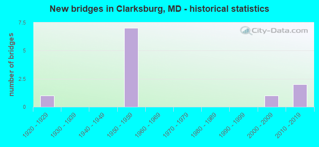
- New bridges - historical statistics
- 11920-1929
- 71950-1959
- 12000-2009
- 22010-2019
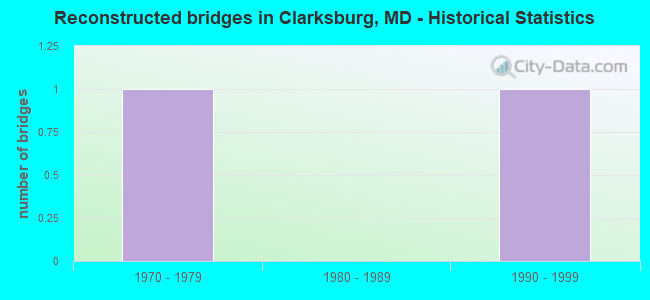
- Reconstructed bridges - Historical Statistics
- 11970-1979
- 01980-1989
- 11990-1999
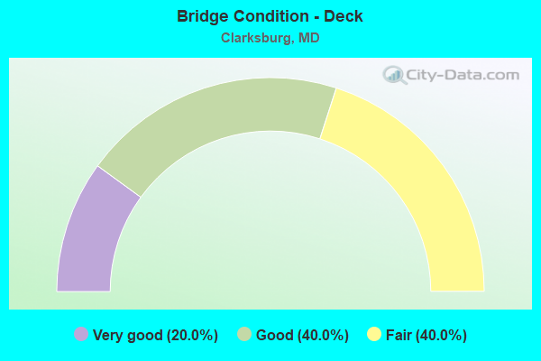
- Bridge Condition - Deck
- 20.0%Very good
- 40.0%Good
- 40.0%Fair
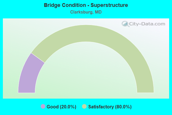
- Bridge Condition - Superstructure
- 20.0%Good
- 80.0%Satisfactory

- Bridge Condition - Substructure
- 20.0%Good
- 80.0%Satisfactory
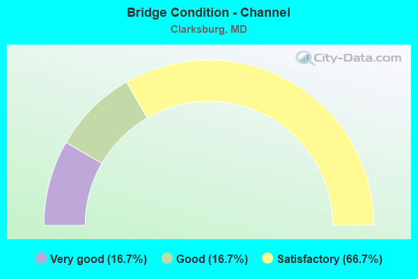
- Bridge Condition - Channel
- 16.7%Very good
- 16.7%Good
- 66.7%Satisfactory
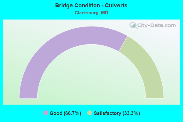
- Bridge Condition - Culverts
- 66.7%Good
- 33.3%Satisfactory
Find on map >> Show street view
Structure Number: 10000015003701, Location: 1.3 MI N OF MD 121 (Lat: 39.246972, Lng: -77.298694), Route carried "on" structure: County highway 200, Year Built: 1952, Year Reconstructed: 1976, Status: Open, Structure Length: 6.58m (21.59ft), Average Daily Traffic: 2,540 (year 2018), Truck Traffic: 5%, Average Future Daily Traffic: 4,081 (year 2038), Design Load: H 20, Features Intersected: IS 270, Facility Carried by Structure: COMUS ROAD
Minimum Vertical Clearance: 30+ m (98+ ft), Kilometerpoint: 0.225, Lanes on structure: 2, Lanes under structure: 4, Owner: State Highway Agency, Approaching Roadway Width: 8.5m (27.9ft), Skew: 2 degrees, Material/Design: Steel, Design/Construction: Stringer/Multi-beam, Number Of Spans In Main Unit: 4, Length of Maximum Span: 20.4m (66.9ft), Curb-To-Curb Width: 7.9m (25.9ft), Out-to-Out Width: 9.8m (32.2ft)
Condition: Deck: Fair, Superstructure: Satisfactory, Substructure: Satisfactory, Inventory Rating: 63.5 metric tons, Method Used To Determine Inventory Rating: Load Factor (LF), Structural Evaluation: Equal to present minimum criteria, Deck Geometry: High priority of corrective action, Underclear: Somewhat better than minimum adequacy, Approach Roadway Alignment: Equal to present minimum criteria, Designated Inspection Frequency: Every 24 months, Inspection Date: November 2020, Deck Structure Type: Concrete Cast-file-Place, Wearing Surface/Protective System: Wearing Surface: Monolithic Concrete
Find on map >> Show street view
Structure Number: 10000015003901, Location: 1.28 MILES S OF MD 121 (Lat: 39.214150, Lng: -77.276892), Route carried "on" structure: Interstate 270, Year Built: 1954, Year Reconstructed: 1998, Status: Open, Structure Length: 3.20m (10.50ft), Average Daily Traffic: 98,097 (year 2009), Truck Traffic: 8%, Average Future Daily Traffic: 133,637 (year 2029), Design Load: HS 20, Features Intersected: WEST OLD BALTIMORE RD
Minimum Vertical Clearance: 30+ m (98+ ft), Kilometerpoint: 27.594, Lanes on structure: 6, Lanes under structure: 2, Base Highway Network: Yes, Owner: State Highway Agency, Approaching Roadway Width: 44.2m (145.0ft), Skew: 30 degrees, Material/Design: Steel continuous, Design/Construction: Stringer/Multi-beam, Number Of Spans In Main Unit: 3, Length of Maximum Span: 11.6m (38.1ft), Curb-To-Curb Width: 42.4m (139.1ft), Out-to-Out Width: 44.3m (145.3ft)
Condition: Deck: Good, Superstructure: Satisfactory, Substructure: Satisfactory, Operating Rating: 89.3 metric tons, Method Used To Determine Operating Rating: Load Factor (LF), Inventory Rating: 53.5 metric tons, Method Used To Determine Inventory Rating: Load Factor (LF), Structural Evaluation: Equal to present minimum criteria, Deck Geometry: Superior to present desirable criteria, Underclear: Meets minimum limits, Approach Roadway Alignment: Equal to present desirable criteria, Length Of Structure Improvement: 3.20m (10.50ft), Designated Inspection Frequency: Every 24 months, Inspection Date: March 2020, Bridge Improvement Cost: $466,000, Roadway Improvement Cost: $47,000, Total Project Cost: $513,000, Deck Structure Type: Concrete Cast-file-Place, Wearing Surface/Protective System: Wearing Surface: Monolithic Concrete, Deck Protection: Epoxy Coated Reinforcing
Find on map >> Show street view
Structure Number: 10000015004002, Location: 1.84MILES S OF MD 118 (Lat: 39.206817, Lng: -77.273114), Route carried "on" structure: Interstate 270, Year Built: 1954, Status: Open, Structure Length: 1.28m (4.20ft), Average Daily Traffic: 98,097 (year 2009), Truck Traffic: 8%, Average Future Daily Traffic: 133,637 (year 2029), Design Load: H 20, Features Intersected: LITTLE SENECA CREEK
Minimum Vertical Clearance: 30+ m (98+ ft), Kilometerpoint: 26.711, Lanes on structure: 4, Base Highway Network: Yes, Owner: State Highway Agency, Approaching Roadway Width: 36.0m (118.1ft), Material/Design: Concrete, Design/Construction: Culvert, Length of Maximum Span: 6.1m (20.0ft)
Condition: Channel: Good, Culverts: Satisfactory, Structural Evaluation: Equal to present minimum criteria, Waterway Adequacy: Better than present minimum criteria, Approach Roadway Alignment: Equal to present desirable criteria, Designated Inspection Frequency: Every 24 months, Inspection Date: September 2020
Find on map >> Show street view
Structure Number: 10000015005401, Location: 1.44 MILES NORTH OF MD 27 (Lat: 39.221475, Lng: -77.259603), Route carried "on" structure: State highway 355, Year Built: 1922, Status: Open, Structure Length: 0.85m (2.79ft), Average Daily Traffic: 13,820 (year 2009), Truck Traffic: 8%, Average Future Daily Traffic: 16,972 (year 2026), Features Intersected: LITTLE SENECA CREEK
Minimum Vertical Clearance: 30+ m (98+ ft), Kilometerpoint: 34.014, Lanes on structure: 2, Owner: State Highway Agency, Approaching Roadway Width: 7.6m (24.9ft), Skew: 3 degrees, Material/Design: Concrete, Design/Construction: Tee Beam, Number Of Spans In Main Unit: 1, Length of Maximum Span: 7.6m (24.9ft), Curb-To-Curb Width: 7.5m (24.6ft), Out-to-Out Width: 8.1m (26.6ft)
Condition: Deck: Fair, Superstructure: Satisfactory, Substructure: Satisfactory, Channel: Satisfactory, Operating Rating: 83.0 metric tons, Method Used To Determine Operating Rating: Load Factor (LF), Inventory Rating: 49.4 metric tons, Method Used To Determine Inventory Rating: Load Factor (LF), Structural Evaluation: Equal to present minimum criteria, Deck Geometry: High priority of replacement, Waterway Adequacy: Equal to present minimum criteria, Approach Roadway Alignment: Equal to present desirable criteria, Length Of Structure Improvement: 0.85m (2.79ft), Designated Inspection Frequency: Every 24 months, Inspection Date: August 2020, Bridge Improvement Cost: $45,000, Roadway Improvement Cost: $4,000, Total Project Cost: $50,000, Deck Structure Type: Concrete Cast-file-Place, Wearing Surface/Protective System: Wearing Surface: Bituminous
Find on map >> Show street view
Structure Number: 200000AA200903, Location: 0.4 MI SE OF MD 295 (Lat: 39.253633, Lng: -77.234569), Route carried "on" structure: County highway , Year Built: 2001, Status: Open, Structure Length: 1.58m (5.18ft), Average Daily Traffic: 25,990 (year 2018), Average Future Daily Traffic: 27,000 (year 2040), Design Load: HS 25 or greater, Features Intersected: PINEY RUN, Facility Carried by Structure: ARUNDEL MILLS BOUL
Minimum Vertical Clearance: 30+ m (98+ ft), Kilometerpoint: 1.850, Lanes on structure: 4, Owner: County Highway Agency, Approaching Roadway Width: 14.6m (47.9ft), Skew: 34 degrees, Material/Design: Steel, Design/Construction: Culvert, Length of Maximum Span: 4.0m (13.1ft), Curb or Sidewalk Widths: Left: 0.2m (0.7ft), Right: 0.2m (0.7ft)
Condition: Channel: Satisfactory, Culverts: Good, Structural Evaluation: Better than present minimum criteria, Waterway Adequacy: Equal to present desirable criteria, Approach Roadway Alignment: Equal to present desirable criteria, Designated Inspection Frequency: Every 24 months, Inspection Date: July 2021
Find on map >> Show street view
Structure Number: 200000HO001201, Location: 0.5 MI S OF MD RTE 175 (Lat: 39.243639, Lng: -77.323533), Route carried "on" structure: County highway 121, Year Built: 1955, Status: Open, Structure Length: 1.04m (3.41ft), Average Daily Traffic: 6,745 (year 2000), Truck Traffic: 4%, Average Future Daily Traffic: 12,320 (year 2015), Features Intersected: DORSEY RUN, Facility Carried by Structure: DORSEY RUN ROAD
Minimum Vertical Clearance: 30+ m (98+ ft), Kilometerpoint: 2.333, Lanes on structure: 2, Owner: County Highway Agency, Approaching Roadway Width: 9.8m (32.2ft), Material/Design: Steel, Design/Construction: Stringer/Multi-beam, Number Of Spans In Main Unit: 1, Length of Maximum Span: 9.1m (29.9ft), Curb or Sidewalk Widths: Left: 0.1m (0.3ft), Right: 0.1m (0.3ft), Curb-To-Curb Width: 7.4m (24.3ft), Out-to-Out Width: 8.0m (26.2ft)
Condition: Deck: Very good, Superstructure: Satisfactory, Substructure: Satisfactory, Channel: Satisfactory, Operating Rating: 74.4 metric tons, Method Used To Determine Operating Rating: Load Factor (LF), Inventory Rating: 44.4 metric tons, Method Used To Determine Inventory Rating: Load Factor (LF), Structural Evaluation: Equal to present minimum criteria, Deck Geometry: High priority of replacement, Waterway Adequacy: Equal to present minimum criteria, Approach Roadway Alignment: Equal to present desirable criteria, Length Of Structure Improvement: 1.04m (3.41ft), Designated Inspection Frequency: Every 24 months, Inspection Date: April 2020, Bridge Improvement Cost: $200,000, Roadway Improvement Cost: $350,000, Total Project Cost: $750,000, Deck Structure Type: Concrete Cast-file-Place, Wearing Surface/Protective System: Wearing Surface: Bituminous
Find on map >> Show street view
Structure Number: 200000M-037301, Location: 0.1 MI. E. OF MD 355 (Lat: 39.223703, Lng: -77.259561), Route carried "on" structure: County highway , Year Built: 2014, Status: Open, Structure Length: 4.11m (13.48ft), Average Daily Traffic: 10,875 (year 2018), Truck Traffic: 5%, Average Future Daily Traffic: 17,254 (year 2040), Features Intersected: LITTLE SENECA CREEK, Facility Carried by Structure: LITTLE SENECA PKWY
Minimum Vertical Clearance: 30+ m (98+ ft), Kilometerpoint: 0.000, Lanes on structure: 4, Owner: County Highway Agency, Approaching Roadway Width: 15.9m (52.2ft), Skew: 21 degrees, Material/Design: Prestressed concrete, Design/Construction: Stringer/Multi-beam, Number Of Spans In Main Unit: 1, Length of Maximum Span: 39.0m (128.0ft), Curb or Sidewalk Widths: Left: 2.1m (6.9ft), Right: 3.7m (12.1ft), Curb-To-Curb Width: 15.9m (52.2ft), Out-to-Out Width: 24.1m (79.1ft)
Condition: Deck: Good, Superstructure: Good, Substructure: Good, Channel: Satisfactory, Operating Rating: 74.8 metric tons, Method Used To Determine Operating Rating: Load and Resistance Factor Rating (LRFR) rating reported by rating factor(RF) method using HL-93 loadings, Inventory Rating: 59.9 metric tons, Method Used To Determine Inventory Rating: Load and Resistance Factor Rating (LRFR) rating reported by rating factor(RF) method using HL-93 loadings, Structural Evaluation: Better than present minimum criteria, Deck Geometry: Meets minimum limits, Waterway Adequacy: Superior to present desirable criteria, Approach Roadway Alignment: Equal to present desirable criteria, Designated Inspection Frequency: Every 24 months, Inspection Date: March 2020, Deck Structure Type: Concrete Cast-file-Place, Wearing Surface/Protective System: Wearing Surface: Integral Concrete, Membrane: Built-up, Deck Protection: Epoxy Coated Reinforcing
Find on map >> Show street view
Structure Number: 200000M-037402, Location: 0.5 MI. E. OF MD 355 (Lat: 39.227711, Lng: -77.254728), Route carried "on" structure: County highway 7669, Year Built: 2011, Status: Open, Structure Length: 0.76m (2.49ft), Average Daily Traffic: 10,542 (year 2018), Truck Traffic: 5%, Average Future Daily Traffic: 16,700 (year 2040), Features Intersected: LITTLE SENECA CREEK TRIB, Facility Carried by Structure: LITTLE SENECA PKWY
Minimum Vertical Clearance: 30+ m (98+ ft), Kilometerpoint: 0.000, Lanes on structure: 4, Owner: County Highway Agency, Approaching Roadway Width: 15.9m (52.2ft), Skew: 1 degrees, Material/Design: Concrete, Design/Construction: Culvert, Length of Maximum Span: 2.1m (6.9ft), Curb or Sidewalk Widths: Left: 2.4m (7.9ft), Right: 1.5m (4.9ft)
Condition: Channel: Very good, Culverts: Good, Operating Rating: 72.6 metric tons, Method Used To Determine Operating Rating: Load Factor (LF), Inventory Rating: 42.2 metric tons, Method Used To Determine Inventory Rating: Load Factor (LF), Structural Evaluation: Better than present minimum criteria, Waterway Adequacy: Superior to present desirable criteria, Approach Roadway Alignment: Equal to present desirable criteria, Designated Inspection Frequency: Every 24 months, Inspection Date: March 2020, Wearing Surface/Protective System: Wearing Surface: Bituminous
Find on map >> Show street view
Structure Number: 10000015003701, Location: 1.3 MI N OF MD 121 (Lat: 39.247031, Lng: -77.298664), Route carried "under" structure: Interstate 270, Year Built: 1952, Structure Length: 0. m, Average Daily Traffic: 94,940 (year 2009), Features Intersected: IS 270, Facility Carried by Structure: COMUS ROAD
Minimum Vertical Clearance: 4.88m (16.01ft), Kilometerpoint: 31.746, Lanes on structure: 2, Lanes under structure: 4, Material/Design: Steel, Design/Construction: Stringer/Multi-beam, Length of Maximum Span: 20.4m (66.9ft)
Find on map >> Show street view
Structure Number: 10000015003801, Location: 1.28 M N OF BR NO 1503900 (Lat: 39.231567, Lng: -77.285264), Route carried "under" structure: Interstate 270, Year Built: 1952, Structure Length: 0. m, Average Daily Traffic: 94,940 (year 2009), Features Intersected: IS 270, Facility Carried by Structure: MD 121
Minimum Vertical Clearance: 5.18m (16.99ft), Kilometerpoint: 29.654, Lanes on structure: 2, Lanes under structure: 4, Material/Design: Steel continuous, Design/Construction: Stringer/Multi-beam, Length of Maximum Span: 20.7m (67.9ft)
Find on map >> Show street view
Structure Number: 10000015003901, Location: 1.28 MILES E OF MD 121 (Lat: 39.214150, Lng: -77.276892), Route carried "under" structure: County highway 231, Year Built: 1954, Structure Length: 0. m, Average Daily Traffic: 1,580 (year 2009), Features Intersected: WEST OLD BALTIMORE RD, Facility Carried by Structure: IS 270
Minimum Vertical Clearance: 4.27m (14.01ft), Kilometerpoint: 2.172, Lanes on structure: 2, Lanes under structure: 2, Material/Design: Steel continuous, Design/Construction: Stringer/Multi-beam, Length of Maximum Span: 11.6m (38.1ft)