Bridge Statistics for Clarkson, New York (NY)
Condition, Traffic, Stress, Structural Evaluation, Project Costs
- National Bridge Inventory (NBI) Statistics
- 15Number of bridges
- 89ft / 26.9mTotal length
- $13,892,000Total costs
- 34,272Total average daily traffic
- 1,727Total average daily truck traffic
- 38,751Total future (year 2036) average daily traffic
- National Bridge Inventory (NBI) Registered Bridges for Clarkson
- No street view available for this location
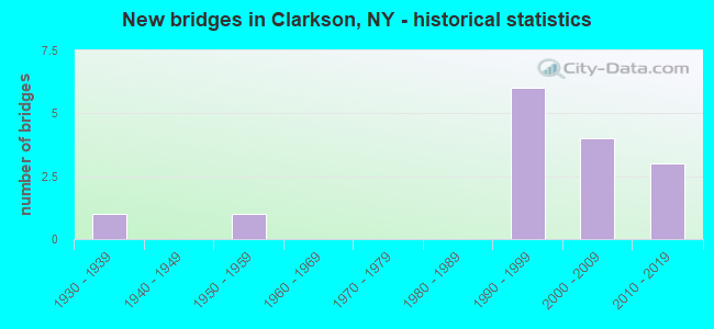
- New bridges - historical statistics
- 11930-1939
- 11950-1959
- 61990-1999
- 42000-2009
- 32010-2019
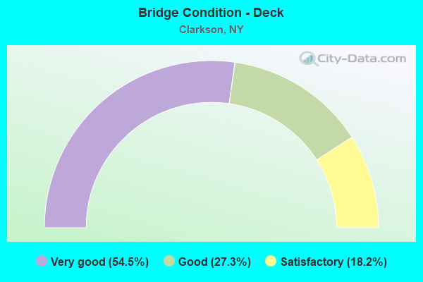
- Bridge Condition - Deck
- 54.5%Very good
- 27.3%Good
- 18.2%Satisfactory
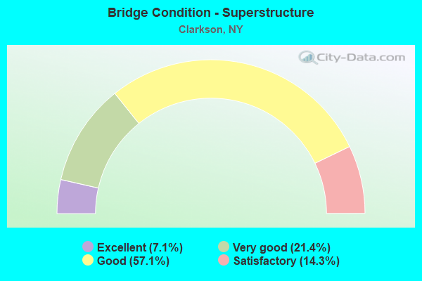
- Bridge Condition - Superstructure
- 7.1%Excellent
- 21.4%Very good
- 57.1%Good
- 14.3%Satisfactory
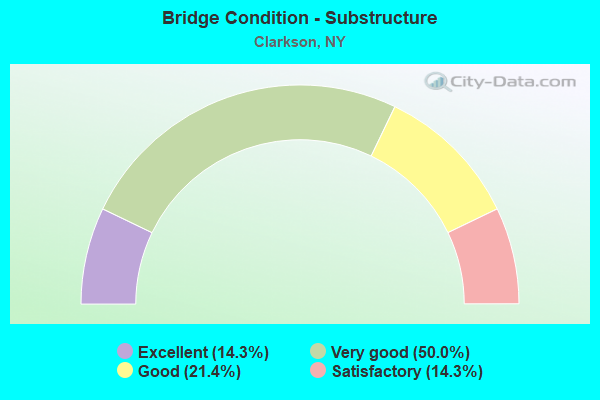
- Bridge Condition - Substructure
- 14.3%Excellent
- 50.0%Very good
- 21.4%Good
- 14.3%Satisfactory
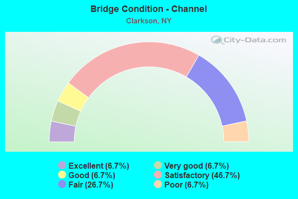
- Bridge Condition - Channel
- 6.7%Excellent
- 6.7%Very good
- 6.7%Good
- 46.7%Satisfactory
- 26.7%Fair
- 6.7%Poor
Find on map >> Show street view
Structure Number: 101478, Location: 18 over MOORMAN CREEK (Lat: 43.284450, Lng: -77.884831), Route carried "on" structure: State highway 18, Year Built: 2012, Status: Open, Structure Length: 1.16m (3.81ft), Average Daily Traffic: 3,462 (year 2020), Truck Traffic: 4%, Average Future Daily Traffic: 3,483 (year 2040), Design Load: HS 25 or greater, Features Intersected: MOORMAN CREEK
Minimum Vertical Clearance: 30+ m (98+ ft), Kilometerpoint: 9.734, Lanes on structure: 2, Base Highway Network: Yes, Owner: State Highway Agency, Approaching Roadway Width: 9.8m (32.2ft), Skew: 3 degrees, Design/Construction: Frame, Number Of Spans In Main Unit: 1, Length of Maximum Span: 11.0m (36.1ft), Curb-To-Curb Width: 9.8m (32.2ft), Out-to-Out Width: 10.8m (35.4ft)
Condition: Deck: Very good, Superstructure: Good, Substructure: Excellent, Channel: Good, Operating Rating: 88.0 metric tons, Method Used To Determine Operating Rating: Load Factor (LF), Inventory Rating: 52.6 metric tons, Method Used To Determine Inventory Rating: Load Factor (LF), Structural Evaluation: Better than present minimum criteria, Deck Geometry: Meets minimum limits, Waterway Adequacy: Equal to present desirable criteria, Approach Roadway Alignment: Equal to present desirable criteria, Length Of Structure Improvement: 1.15m (3.77ft), Designated Inspection Frequency: Every 24 months, Inspection Date: June 2020, Bridge Improvement Cost: $441,000, Roadway Improvement Cost: $258,000, Total Project Cost: $699,000 ( Estimate for 2021), Wearing Surface/Protective System: Wearing Surface: Bituminous, Membrane: Preformed Fabric
Find on map >> Show street view
Structure Number: 10153, Location: 1.9 MI N JCT.RTE 19 + 104 (Lat: 43.259767, Lng: -77.921642), Route carried "on" structure: State highway 19, Year Built: 1994, Status: Open, Structure Length: 1.22m (4.00ft), Average Daily Traffic: 4,838 (year 2018), Truck Traffic: 4%, Average Future Daily Traffic: 5,877 (year 2040), Design Load: HS 25 or greater, Features Intersected: MOORMAN CREEK
Minimum Vertical Clearance: 30+ m (98+ ft), Kilometerpoint: 14.497, Lanes on structure: 2, Base Highway Network: Yes, Owner: State Highway Agency, Approaching Roadway Width: 10.4m (34.1ft), Skew: 1 degrees, Material/Design: Concrete, Design/Construction: Culvert, Number Of Spans In Main Unit: 1, Length of Maximum Span: 11.2m (36.7ft), Curb-To-Curb Width: 10.4m (34.1ft), Out-to-Out Width: 11.0m (36.1ft)
Condition: Channel: Satisfactory, Culverts: Satisfactory, Operating Rating: 80.6 metric tons, Method Used To Determine Operating Rating: Field evaluation and documented engineering judgment, Inventory Rating: 40.8 metric tons, Method Used To Determine Inventory Rating: Field evaluation and documented engineering judgment, Structural Evaluation: Equal to present minimum criteria, Deck Geometry: Somewhat better than minimum adequacy, Waterway Adequacy: Meets minimum limits, Approach Roadway Alignment: Equal to present desirable criteria, Length Of Structure Improvement: 1.21m (3.97ft), Designated Inspection Frequency: Every 24 months, Inspection Date: June 2020, Bridge Improvement Cost: $240,000, Roadway Improvement Cost: $140,000, Total Project Cost: $380,000 ( Estimate for 2021), Wearing Surface/Protective System: Wearing Surface: Bituminous
Find on map >> Show street view
Structure Number: 103645, Location: 1.4MI W JCT RTS 104 + 19 (Lat: 43.240294, Lng: -77.952686), Route carried "on" structure: US 104, Year Built: 1933, Status: Open, Structure Length: 0.82m (2.69ft), Average Daily Traffic: 6,255 (year 2018), Truck Traffic: 9%, Average Future Daily Traffic: 6,314 (year 2040), Features Intersected: MOORMAN CREEK
Minimum Vertical Clearance: 30+ m (98+ ft), Kilometerpoint: 3.974, Lanes on structure: 2, Base Highway Network: Yes, Owner: State Highway Agency, Approaching Roadway Width: 8.5m (27.9ft), Material/Design: Concrete, Design/Construction: Slab, Number Of Spans In Main Unit: 1, Length of Maximum Span: 7.3m (24.0ft), Curb-To-Curb Width: 10.2m (33.5ft), Out-to-Out Width: 11.5m (37.7ft)
Condition: Deck: Satisfactory, Superstructure: Satisfactory, Substructure: Satisfactory, Channel: Satisfactory, Operating Rating: 73.5 metric tons, Method Used To Determine Operating Rating: Load Factor (LF), Inventory Rating: 43.5 metric tons, Method Used To Determine Inventory Rating: Load Factor (LF), Structural Evaluation: Equal to present minimum criteria, Deck Geometry: Meets minimum limits, Waterway Adequacy: Equal to present minimum criteria, Approach Roadway Alignment: Equal to present desirable criteria, Length Of Structure Improvement: 0.82m (2.69ft), Designated Inspection Frequency: Every 24 months, Inspection Date: August 2021, Bridge Improvement Cost: $401,000, Roadway Improvement Cost: $235,000, Total Project Cost: $636,000 ( Estimate for 2021), Wearing Surface/Protective System: Wearing Surface: Bituminous
Find on map >> Show street view
Structure Number: 10436, Location: 1.7 MI S JCT RTS 260 + 18 (Lat: 43.260281, Lng: -77.877533), Route carried "on" structure: State highway 260, Year Built: 1993, Status: Open, Structure Length: 0.73m (2.40ft), Average Daily Traffic: 4,274 (year 2019), Truck Traffic: 4%, Average Future Daily Traffic: 4,458 (year 2040), Features Intersected: OTIS CREEK
Minimum Vertical Clearance: 30+ m (98+ ft), Kilometerpoint: 7.144, Lanes on structure: 2, Base Highway Network: Yes, Owner: State Highway Agency, Approaching Roadway Width: 11.6m (38.1ft), Material/Design: Concrete, Design/Construction: Frame, Number Of Spans In Main Unit: 1, Length of Maximum Span: 6.0m (19.7ft), Curb-To-Curb Width: 10.9m (35.8ft), Out-to-Out Width: 11.6m (38.1ft)
Condition: Deck: Good, Superstructure: Good, Substructure: Very good, Channel: Fair, Operating Rating: 76.9 metric tons, Method Used To Determine Operating Rating: Field evaluation and documented engineering judgment, Inventory Rating: 32.7 metric tons, Method Used To Determine Inventory Rating: Field evaluation and documented engineering judgment, Structural Evaluation: Better than present minimum criteria, Deck Geometry: Somewhat better than minimum adequacy, Waterway Adequacy: Equal to present minimum criteria, Approach Roadway Alignment: Equal to present desirable criteria, Length Of Structure Improvement: 0.73m (2.40ft), Designated Inspection Frequency: Every 24 months, Inspection Date: May 2021, Bridge Improvement Cost: $329,000, Roadway Improvement Cost: $193,000, Total Project Cost: $522,000 ( Estimate for 2021), Wearing Surface/Protective System: Wearing Surface: Bituminous
Find on map >> Show street view
Structure Number: 104361, Location: .5 MI S JCT RTS 260 & 18 (Lat: 43.277619, Lng: -77.869867), Route carried "on" structure: State highway 260, Year Built: 1999, Status: Open, Structure Length: 1.16m (3.81ft), Average Daily Traffic: 4,274 (year 2019), Truck Traffic: 4%, Average Future Daily Traffic: 4,458 (year 2040), Design Load: HS 25 or greater, Features Intersected: BROCKPORT CREEK
Minimum Vertical Clearance: 30+ m (98+ ft), Kilometerpoint: 9.155, Lanes on structure: 2, Base Highway Network: Yes, Owner: State Highway Agency, Approaching Roadway Width: 9.1m (29.9ft), Material/Design: Concrete, Design/Construction: Frame, Number Of Spans In Main Unit: 1, Length of Maximum Span: 10.9m (35.8ft), Curb-To-Curb Width: 9.0m (29.5ft), Out-to-Out Width: 10.0m (32.8ft)
Condition: Deck: Good, Superstructure: Good, Substructure: Very good, Channel: Fair, Operating Rating: 80.4 metric tons, Method Used To Determine Operating Rating: Field evaluation and documented engineering judgment, Inventory Rating: 40.8 metric tons, Method Used To Determine Inventory Rating: Field evaluation and documented engineering judgment, Structural Evaluation: Better than present minimum criteria, Deck Geometry: Meets minimum limits, Waterway Adequacy: High priority of corrective action, Approach Roadway Alignment: Equal to present desirable criteria, Length Of Structure Improvement: 1.15m (3.77ft), Designated Inspection Frequency: Every 24 months, Inspection Date: September 2021, Bridge Improvement Cost: $295,000, Roadway Improvement Cost: $173,000, Total Project Cost: $468,000 ( Estimate for 2021), Wearing Surface/Protective System: Wearing Surface: Bituminous
Find on map >> Show street view
Structure Number: 221108, Location: 1.3 MI NW OF CLARSKON (Lat: 43.247744, Lng: -77.944694), Route carried "on" structure: Other road , Year Built: 1993, Status: Open, Structure Length: 1.40m (4.59ft), Average Daily Traffic: 1,098 (year 2016), Truck Traffic: 3%, Average Future Daily Traffic: 1,537 (year 2036), Design Load: HS 20, Features Intersected: MOORMAN CREEK, Facility Carried by Structure: DRAKE ROAD
Minimum Vertical Clearance: 30+ m (98+ ft), Kilometerpoint: 1.030, Lanes on structure: 2, Owner: County Highway Agency, Approaching Roadway Width: 9.1m (29.9ft), Skew: 2 degrees, Material/Design: Prestressed concrete, Design/Construction: Box Beam or Girders - Multiple, Number Of Spans In Main Unit: 1, Length of Maximum Span: 12.8m (42.0ft), Curb-To-Curb Width: 9.2m (30.2ft), Out-to-Out Width: 10.1m (33.1ft)
Condition: Deck: Very good, Superstructure: Good, Substructure: Good, Channel: Satisfactory, Operating Rating: 79.8 metric tons, Method Used To Determine Operating Rating: Load Factor (LF), Inventory Rating: 32.7 metric tons, Method Used To Determine Inventory Rating: Load Factor (LF), Structural Evaluation: Better than present minimum criteria, Deck Geometry: Somewhat better than minimum adequacy, Waterway Adequacy: Better than present minimum criteria, Approach Roadway Alignment: Equal to present desirable criteria, Length Of Structure Improvement: 1.40m (4.59ft), Designated Inspection Frequency: Every 24 months, Inspection Date: April 2021, Bridge Improvement Cost: $322,000, Roadway Improvement Cost: $188,000, Total Project Cost: $510,000 ( Estimate for 2021), Deck Structure Type: Concrete Cast-file-Place, Wearing Surface/Protective System: Wearing Surface: Bituminous, Deck Protection: Epoxy Coated Reinforcing
Find on map >> Show street view
Structure Number: 331699, Location: 2 MI SE OF HAMLIN (Lat: 43.277272, Lng: -77.907794), Route carried "on" structure: County highway , Year Built: 2007, Status: Open, Structure Length: 0.94m (3.08ft), Average Daily Traffic: 327 (year 2019), Truck Traffic: 5%, Average Future Daily Traffic: 458 (year 2039), Design Load: HS 25 or greater, Features Intersected: MOORMAN CREEK, Facility Carried by Structure: LAWRENCE ROAD
Minimum Vertical Clearance: 30+ m (98+ ft), Kilometerpoint: 1.094, Lanes on structure: 2, Owner: County Highway Agency, Approaching Roadway Width: 10.1m (33.1ft), Material/Design: Concrete, Design/Construction: Frame, Number Of Spans In Main Unit: 1, Length of Maximum Span: 9.1m (29.9ft), Curb-To-Curb Width: 10.2m (33.5ft), Out-to-Out Width: 11.4m (37.4ft)
Condition: Superstructure: Very good, Substructure: Very good, Channel: Satisfactory, Operating Rating: 87.5 metric tons, Method Used To Determine Operating Rating: Load and Resistance Factor Rating (LRFR) rating reported by rating factor(RF) method using HL-93 loadings, Inventory Rating: 67.4 metric tons, Method Used To Determine Inventory Rating: Load and Resistance Factor Rating (LRFR) rating reported by rating factor(RF) method using HL-93 loadings, Structural Evaluation: Equal to present desirable criteria, Deck Geometry: Better than present minimum criteria, Waterway Adequacy: Better than present minimum criteria, Approach Roadway Alignment: Equal to present desirable criteria, Length Of Structure Improvement: 0.94m (3.08ft), Designated Inspection Frequency: Every 24 months, Inspection Date: August 2021, Bridge Improvement Cost: $394,000, Roadway Improvement Cost: $231,000, Total Project Cost: $624,000 ( Estimate for 2021)
Find on map >> Show street view
Structure Number: 3317, Location: 4.2 MI W OF HILTON (Lat: 43.276992, Lng: -77.871858), Route carried "on" structure: County highway , Year Built: 2011, Status: Open, Structure Length: 1.13m (3.71ft), Average Daily Traffic: 327 (year 2019), Truck Traffic: 5%, Average Future Daily Traffic: 458 (year 2039), Design Load: HS 25 or greater, Features Intersected: BROCKPORT CREEK, Facility Carried by Structure: LAWRENCE ROAD
Minimum Vertical Clearance: 30+ m (98+ ft), Kilometerpoint: 4.006, Lanes on structure: 2, Owner: County Highway Agency, Approaching Roadway Width: 10.4m (34.1ft), Material/Design: Concrete, Design/Construction: Frame, Number Of Spans In Main Unit: 1, Length of Maximum Span: 11.0m (36.1ft), Curb-To-Curb Width: 10.4m (34.1ft), Out-to-Out Width: 11.4m (37.4ft)
Condition: Deck: Very good, Superstructure: Very good, Substructure: Very good, Channel: Satisfactory, Operating Rating: 53.5 metric tons, Method Used To Determine Operating Rating: Load Factor (LF), Inventory Rating: 31.8 metric tons, Method Used To Determine Inventory Rating: Load Factor (LF), Structural Evaluation: Better than present minimum criteria, Deck Geometry: Better than present minimum criteria, Waterway Adequacy: Somewhat better than minimum adequacy, Approach Roadway Alignment: Equal to present desirable criteria, Length Of Structure Improvement: 1.12m (3.67ft), Designated Inspection Frequency: Every 24 months, Inspection Date: November 2021, Bridge Improvement Cost: $454,000, Roadway Improvement Cost: $266,000, Total Project Cost: $719,000 ( Estimate for 2021), Wearing Surface/Protective System: Wearing Surface: Bituminous
Find on map >> Show street view
Structure Number: 331701, Location: 3 MI W OF HILTON (Lat: 43.276872, Lng: -77.849983), Route carried "on" structure: County highway , Year Built: 2007, Status: Open, Structure Length: 0.79m (2.59ft), Average Daily Traffic: 315 (year 2017), Truck Traffic: 1%, Average Future Daily Traffic: 441 (year 2037), Design Load: HS 25 or greater, Features Intersected: OTIS CREEK, Facility Carried by Structure: LAWRENCE ROAD
Minimum Vertical Clearance: 30+ m (98+ ft), Kilometerpoint: 5.792, Lanes on structure: 2, Owner: County Highway Agency, Approaching Roadway Width: 10.1m (33.1ft), Skew: 1 degrees, Material/Design: Concrete, Design/Construction: Frame, Number Of Spans In Main Unit: 1, Length of Maximum Span: 7.6m (24.9ft), Curb-To-Curb Width: 10.2m (33.5ft), Out-to-Out Width: 11.2m (36.7ft)
Condition: Deck: Very good, Superstructure: Very good, Substructure: Very good, Channel: Satisfactory, Operating Rating: 86.2 metric tons, Method Used To Determine Operating Rating: Load Factor (LF), Inventory Rating: 51.7 metric tons, Method Used To Determine Inventory Rating: Load Factor (LF), Structural Evaluation: Equal to present desirable criteria, Deck Geometry: Better than present minimum criteria, Waterway Adequacy: Somewhat better than minimum adequacy, Approach Roadway Alignment: Somewhat better than minimum adequacy, Length Of Structure Improvement: 0.79m (2.59ft), Designated Inspection Frequency: Every 24 months, Inspection Date: November 2021, Bridge Improvement Cost: $388,000, Roadway Improvement Cost: $227,000, Total Project Cost: $615,000 ( Estimate for 2021), Wearing Surface/Protective System: Wearing Surface: Bituminous
Find on map >> Show street view
Structure Number: 331702, Location: 4 MI SW OF HILTON (Lat: 43.258653, Lng: -77.857203), Route carried "on" structure: County highway , Year Built: 1998, Status: Open, Structure Length: 1.01m (3.31ft), Average Daily Traffic: 1,105 (year 2017), Truck Traffic: 5%, Average Future Daily Traffic: 1,547 (year 2037), Features Intersected: SALMON CREEK, Facility Carried by Structure: IRELAND ROAD
Minimum Vertical Clearance: 30+ m (98+ ft), Kilometerpoint: 1.689, Lanes on structure: 2, Owner: County Highway Agency, Approaching Roadway Width: 10.1m (33.1ft), Material/Design: Concrete, Design/Construction: Frame, Number Of Spans In Main Unit: 1, Length of Maximum Span: 9.4m (30.8ft), Curb-To-Curb Width: 10.2m (33.5ft), Out-to-Out Width: 11.1m (36.4ft)
Condition: Deck: Satisfactory, Superstructure: Satisfactory, Substructure: Very good, Channel: Very good, Operating Rating: 66.7 metric tons, Method Used To Determine Operating Rating: Load and Resistance Factor Rating (LRFR) rating reported by rating factor(RF) method using HL-93 loadings, Inventory Rating: 51.2 metric tons, Method Used To Determine Inventory Rating: Load and Resistance Factor Rating (LRFR) rating reported by rating factor(RF) method using HL-93 loadings, Structural Evaluation: Equal to present minimum criteria, Deck Geometry: Somewhat better than minimum adequacy, Waterway Adequacy: Better than present minimum criteria, Approach Roadway Alignment: Equal to present desirable criteria, Length Of Structure Improvement: 1.00m (3.28ft), Designated Inspection Frequency: Every 24 months, Inspection Date: April 2021, Bridge Improvement Cost: $297,000, Roadway Improvement Cost: $174,000, Total Project Cost: $471,000 ( Estimate for 2021)
Find on map >> Show street view
Structure Number: 331703, Location: 2.9 MI SE OF HAMLIN (Lat: 43.262753, Lng: -77.914483), Route carried "on" structure: County highway , Year Built: 2008, Status: Open, Structure Length: 1.31m (4.30ft), Average Daily Traffic: 378 (year 2017), Truck Traffic: 6%, Average Future Daily Traffic: 381 (year 2040), Design Load: HS 25 or greater, Features Intersected: MOORMAN CREEK, Facility Carried by Structure: LAWTON ROAD
Minimum Vertical Clearance: 30+ m (98+ ft), Kilometerpoint: 0.579, Lanes on structure: 2, Owner: County Highway Agency, Approaching Roadway Width: 10.4m (34.1ft), Skew: 3 degrees, Material/Design: Concrete, Design/Construction: Frame, Number Of Spans In Main Unit: 1, Length of Maximum Span: 12.2m (40.0ft), Curb-To-Curb Width: 10.2m (33.5ft), Out-to-Out Width: 11.2m (36.7ft)
Condition: Deck: Good, Superstructure: Good, Substructure: Excellent, Channel: Fair, Operating Rating: 81.3 metric tons, Method Used To Determine Operating Rating: Field evaluation and documented engineering judgment, Inventory Rating: 40.8 metric tons, Method Used To Determine Inventory Rating: Field evaluation and documented engineering judgment, Structural Evaluation: Better than present minimum criteria, Deck Geometry: Better than present minimum criteria, Waterway Adequacy: Equal to present minimum criteria, Approach Roadway Alignment: Equal to present desirable criteria, Length Of Structure Improvement: 1.31m (4.30ft), Designated Inspection Frequency: Every 24 months, Inspection Date: September 2020, Bridge Improvement Cost: $264,000, Roadway Improvement Cost: $154,000, Total Project Cost: $418,000 ( Estimate for 2021), Wearing Surface/Protective System: Wearing Surface: Bituminous
Find on map >> Show street view
Structure Number: 331748, Location: 2.4 MI NE OF BROCKPORT (Lat: 43.244547, Lng: -77.917289), Route carried "on" structure: Other road , Year Built: 2007, Status: Open, Structure Length: 1.10m (3.61ft), Average Daily Traffic: 1,271 (year 2017), Truck Traffic: 4%, Average Future Daily Traffic: 1,779 (year 2037), Design Load: HS 25 or greater, Features Intersected: BROCKPORT CREEK, Facility Carried by Structure: GILMORE ROAD
Minimum Vertical Clearance: 30+ m (98+ ft), Kilometerpoint: 0.370, Lanes on structure: 2, Owner: County Highway Agency, Approaching Roadway Width: 9.1m (29.9ft), Skew: 3 degrees, Material/Design: Concrete, Design/Construction: Frame, Number Of Spans In Main Unit: 1, Length of Maximum Span: 10.7m (35.1ft), Curb or Sidewalk Widths: Left: 0.0m, Right: 1.6m (5.2ft), Curb-To-Curb Width: 9.4m (30.8ft), Out-to-Out Width: 12.1m (39.7ft)
Condition: Superstructure: Good, Substructure: Good, Channel: Satisfactory, Operating Rating: 59.9 metric tons, Method Used To Determine Operating Rating: Load Factor (LF), Inventory Rating: 36.3 metric tons, Method Used To Determine Inventory Rating: Load Factor (LF), Structural Evaluation: Better than present minimum criteria, Deck Geometry: Somewhat better than minimum adequacy, Waterway Adequacy: Better than present minimum criteria, Approach Roadway Alignment: Equal to present desirable criteria, Length Of Structure Improvement: 1.09m (3.58ft), Designated Inspection Frequency: Every 24 months, Inspection Date: June 2021, Bridge Improvement Cost: $483,000, Roadway Improvement Cost: $283,000, Total Project Cost: $765,000 ( Estimate for 2021)
Find on map >> Show street view
Structure Number: 331777, Location: 3.1 MILES SW OF HILTON (Lat: 43.265164, Lng: -77.842928), Route carried "on" structure: County highway , Year Built: 1998, Status: Open, Structure Length: 1.04m (3.41ft), Average Daily Traffic: 1,343 (year 2016), Truck Traffic: 5%, Average Future Daily Traffic: 1,880 (year 2036), Design Load: HS 25 or greater, Features Intersected: SALMON CREEK, Facility Carried by Structure: CLARKSON PARMA TL
Minimum Vertical Clearance: 30+ m (98+ ft), Kilometerpoint: 4.956, Lanes on structure: 2, Owner: County Highway Agency, Approaching Roadway Width: 7.9m (25.9ft), Skew: 1 degrees, Material/Design: Concrete, Design/Construction: Frame, Number Of Spans In Main Unit: 1, Length of Maximum Span: 9.4m (30.8ft), Curb-To-Curb Width: 10.2m (33.5ft), Out-to-Out Width: 11.1m (36.4ft)
Condition: Superstructure: Good, Substructure: Satisfactory, Channel: Poor, Operating Rating: 79.3 metric tons, Method Used To Determine Operating Rating: Field evaluation and documented engineering judgment, Inventory Rating: 40.8 metric tons, Method Used To Determine Inventory Rating: Field evaluation and documented engineering judgment, Structural Evaluation: Equal to present minimum criteria, Deck Geometry: Somewhat better than minimum adequacy, Waterway Adequacy: Meets minimum limits, Approach Roadway Alignment: Somewhat better than minimum adequacy, Length Of Structure Improvement: 1.03m (3.38ft), Designated Inspection Frequency: Every 24 months, Inspection Date: October 2020, Bridge Improvement Cost: $432,000, Roadway Improvement Cost: $253,000, Total Project Cost: $685,000 ( Estimate for 2021)
Find on map >> Show street view
Structure Number: 331778, Location: 1.7 MILES WEST OF HILTON (Lat: 43.283219, Lng: -77.834403), Route carried "on" structure: County highway , Year Built: 1952, Year Reconstructed: 2019, Status: Open, Structure Length: 1.65m (5.41ft), Average Daily Traffic: 1,650 (year 2016), Truck Traffic: 4%, Average Future Daily Traffic: 2,310 (year 2036), Design Load: HS 20, Features Intersected: OTIS CREEK, Facility Carried by Structure: CLARKSON PARMA TL
Minimum Vertical Clearance: 30+ m (98+ ft), Kilometerpoint: 7.064, Lanes on structure: 2, Owner: County Highway Agency, Approaching Roadway Width: 9.1m (29.9ft), Material/Design: Steel, Design/Construction: Stringer/Multi-beam, Number Of Spans In Main Unit: 1, Length of Maximum Span: 15.8m (51.8ft), Curb-To-Curb Width: 9.1m (29.9ft), Out-to-Out Width: 10.1m (33.1ft)
Condition: Deck: Very good, Superstructure: Good, Substructure: Good, Channel: Fair, Operating Rating: 40.5 metric tons, Method Used To Determine Operating Rating: Load and Resistance Factor Rating (LRFR) rating reported by rating factor(RF) method using HL-93 loadings, Inventory Rating: 31.1 metric tons, Method Used To Determine Inventory Rating: Load and Resistance Factor Rating (LRFR) rating reported by rating factor(RF) method using HL-93 loadings, Structural Evaluation: Better than present minimum criteria, Deck Geometry: Somewhat better than minimum adequacy, Waterway Adequacy: Equal to present desirable criteria, Approach Roadway Alignment: Equal to present desirable criteria, Length Of Structure Improvement: 1.64m (5.38ft), Designated Inspection Frequency: Every 24 months, Inspection Date: August 2021, Bridge Improvement Cost: $661,000, Roadway Improvement Cost: $387,000, Total Project Cost: $1,047,000 ( Estimate for 2021), Deck Structure Type: Concrete Cast-file-Place, Wearing Surface/Protective System: Wearing Surface: Integral Concrete, Deck Protection: Epoxy Coated Reinforcing
Find on map >> Show street view
Structure Number: 444325, Location: JCT BARGE C+RTE31 BKPT (Lat: 43.220939, Lng: -77.996008), Route carried "on" structure: State highway 31, Year Built: 2010, Status: Open, Structure Length: 11.43m (37.50ft), Average Daily Traffic: 3,355 (year 2018), Truck Traffic: 5%, Average Future Daily Traffic: 3,370 (year 2040), Design Load: HL 93, Features Intersected: Erie Canal Trailway, ERI
Minimum Vertical Clearance: 30+ m (98+ ft), Kilometerpoint: 0.048, Lanes on structure: 2, Base Highway Network: Yes, Owner: State Highway Agency, Approaching Roadway Width: 11.9m (39.0ft), Skew: 3 degrees, Navigation Control: Yes ( Vertical Clearance: 4.5m (14.8ft), Horizontal Clearance: 22.8m (74.8ft)), Material/Design: Steel continuous, Design/Construction: Stringer/Multi-beam, Number Of Spans In Main Unit: 3, Length of Maximum Span: 47.5m (155.8ft), Curb-To-Curb Width: 12.0m (39.4ft), Out-to-Out Width: 13.0m (42.7ft)
Condition: Deck: Very good, Superstructure: Excellent, Substructure: Very good, Channel: Excellent, Operating Rating: 87.1 metric tons, Method Used To Determine Operating Rating: Load Factor (LF), Inventory Rating: 51.7 metric tons, Method Used To Determine Inventory Rating: Load Factor (LF), Structural Evaluation: Equal to present desirable criteria, Deck Geometry: Somewhat better than minimum adequacy, Waterway Adequacy: Equal to present minimum criteria, Approach Roadway Alignment: Equal to present desirable criteria, Length Of Structure Improvement: 11.43m (37.50ft), Designated Inspection Frequency: Every 24 months, Inspection Date: July 2020, Bridge Improvement Cost: $3,364,000, Roadway Improvement Cost: $1,970,000, Total Project Cost: $5,333,000 ( Estimate for 2021), Deck Structure Type: Concrete Cast-file-Place, Wearing Surface/Protective System: Wearing Surface: Monolithic Concrete, Deck Protection: Epoxy Coated Reinforcing