Bridge Statistics for Clay, West Virginia (WV)
Condition, Traffic, Stress, Structural Evaluation, Project Costs
- National Bridge Inventory (NBI) Statistics
- 17Number of bridges
- 213ft / 64.8mTotal length
- $1,800,000Total costs
- 10,870Total average daily traffic
- 927Total average daily truck traffic
- 14,903Total future (year 2038) average daily traffic
- National Bridge Inventory (NBI) Registered Bridges for Clay
- No street view available for this location
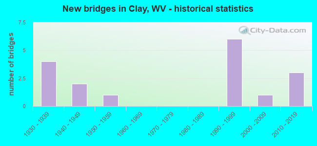
- New bridges - historical statistics
- 41930-1939
- 21940-1949
- 11950-1959
- 61990-1999
- 12000-2009
- 32010-2019

- Bridge Condition - Deck
- 9.1%Very good
- 45.5%Good
- 9.1%Satisfactory
- 18.2%Fair
- 18.2%Poor

- Bridge Condition - Superstructure
- 25.0%Very good
- 33.3%Good
- 8.3%Satisfactory
- 16.7%Fair
- 16.7%Poor

- Bridge Condition - Substructure
- 25.0%Very good
- 33.3%Good
- 16.7%Satisfactory
- 16.7%Fair
- 8.3%Poor

- Bridge Condition - Channel
- 5.9%Excellent
- 35.3%Very good
- 17.6%Good
- 17.6%Satisfactory
- 23.5%Fair

- Bridge Condition - Culverts
- 20.0%Good
- 60.0%Fair
- 20.0%Poor
Find on map >> Show street view
Structure Number: 8A013, Location: 2.28 MI N OF WV 16 (Lat: 38.449389, Lng: -81.145039), Route carried "on" structure: County highway 5, Year Built: 1952, Year Reconstructed: 1987, Status: Open, Structure Length: 0.83m (2.72ft), Average Daily Traffic: 150 (year 2018), Truck Traffic: 10%, Average Future Daily Traffic: 183 (year 2038), Design Load: HS 20, Features Intersected: BLUE KNOB CREEK
Minimum Vertical Clearance: 30+ m (98+ ft), Kilometerpoint: 3.669, Lanes on structure: 2, Owner: State Highway Agency, Approaching Roadway Width: 4.9m (16.1ft), Material/Design: Prestressed concrete, Design/Construction: Box Beam or Girders - Multiple, Number Of Spans In Main Unit: 1, Length of Maximum Span: 6.9m (22.6ft), Curb-To-Curb Width: 6.2m (20.3ft), Out-to-Out Width: 6.4m (21.0ft)
Condition: Deck: Very good, Superstructure: Very good, Substructure: Satisfactory, Channel: Very good, Operating Rating: 88.9 metric tons, Method Used To Determine Operating Rating: Load Factor (LF), Inventory Rating: 76.2 metric tons, Method Used To Determine Inventory Rating: Load Factor (LF), Structural Evaluation: Equal to present minimum criteria, Deck Geometry: Meets minimum limits, Waterway Adequacy: Better than present minimum criteria, Approach Roadway Alignment: Equal to present desirable criteria, Designated Inspection Frequency: Every 24 months, Inspection Date: June 2020, Deck Structure Type: Other, Wearing Surface/Protective System: Wearing Surface: Monolithic Concrete, Deck Protection: Epoxy Coated Reinforcing
Find on map >> Show street view
Structure Number: 8A041, Location: 1.43 MI N OF CR 17 (Lat: 38.399411, Lng: -81.113719), Route carried "on" structure: State highway 16, Year Built: 1944, Status: Open, Structure Length: 0.78m (2.56ft), Average Daily Traffic: 1,800 (year 2018), Truck Traffic: 6%, Average Future Daily Traffic: 2,196 (year 2038), Features Intersected: MIDDLE CREEK
Minimum Vertical Clearance: 30+ m (98+ ft), Kilometerpoint: 19.875, Lanes on structure: 2, Owner: State Highway Agency, Approaching Roadway Width: 6.4m (21.0ft), Skew: 3 degrees, Material/Design: Concrete, Design/Construction: Slab, Number Of Spans In Main Unit: 1, Length of Maximum Span: 7.3m (24.0ft), Curb or Sidewalk Widths: Left: 0.2m (0.7ft), Right: 0.2m (0.7ft), Curb-To-Curb Width: 8.2m (26.9ft), Out-to-Out Width: 9.1m (29.9ft)
Condition: Deck: Poor, Superstructure: Poor, Substructure: Fair, Channel: Good, Operating Rating: 48.1 metric tons, Method Used To Determine Operating Rating: Field evaluation and documented engineering judgment, Inventory Rating: 21.8 metric tons, Method Used To Determine Inventory Rating: Field evaluation and documented engineering judgment, Structural Evaluation: Meets minimum limits, Deck Geometry: Meets minimum limits, Waterway Adequacy: Equal to present minimum criteria, Approach Roadway Alignment: Equal to present desirable criteria, Length Of Structure Improvement: 0.78m (2.56ft), Designated Inspection Frequency: Every 24 months, Other Special Inspection Frequency: Every 12 months, Inspection Date: May 2020, Other Special Inspection Date: May 2021, Bridge Improvement Cost: $350,000, Roadway Improvement Cost: $50,000, Total Project Cost: $400,000 ( Estimate for 2021), Deck Structure Type: Concrete Cast-file-Place, Wearing Surface/Protective System: Wearing Surface: Bituminous
Find on map >> Show street view
Structure Number: 8A042, Location: 1.71 MI N OF CR 17 (Lat: 38.402961, Lng: -81.112931), Route carried "on" structure: State highway 16, Year Built: 1944, Status: Open, Structure Length: 0.78m (2.56ft), Average Daily Traffic: 1,800 (year 2018), Truck Traffic: 6%, Average Future Daily Traffic: 2,196 (year 2038), Features Intersected: MIDDLE CREEK
Minimum Vertical Clearance: 30+ m (98+ ft), Kilometerpoint: 20.310, Lanes on structure: 2, Owner: State Highway Agency, Approaching Roadway Width: 5.8m (19.0ft), Skew: 3 degrees, Material/Design: Concrete, Design/Construction: Slab, Number Of Spans In Main Unit: 1, Length of Maximum Span: 7.3m (24.0ft), Curb-To-Curb Width: 8.0m (26.2ft), Out-to-Out Width: 9.0m (29.5ft)
Condition: Deck: Fair, Superstructure: Fair, Substructure: Satisfactory, Channel: Fair, Operating Rating: 53.5 metric tons, Method Used To Determine Operating Rating: Field evaluation and documented engineering judgment, Inventory Rating: 24.5 metric tons, Method Used To Determine Inventory Rating: Field evaluation and documented engineering judgment, Structural Evaluation: Somewhat better than minimum adequacy, Deck Geometry: Meets minimum limits, Waterway Adequacy: Equal to present minimum criteria, Approach Roadway Alignment: Equal to present minimum criteria, Length Of Structure Improvement: 0.78m (2.56ft), Designated Inspection Frequency: Every 24 months, Other Special Inspection Frequency: Every 12 months, Inspection Date: May 2020, Other Special Inspection Date: May 2021, Bridge Improvement Cost: $300,000, Roadway Improvement Cost: $50,000, Total Project Cost: $350,000 ( Estimate for 2021), Deck Structure Type: Concrete Cast-file-Place, Wearing Surface/Protective System: Wearing Surface: Bituminous
Find on map >> Show street view
Structure Number: 8A05, Location: 0.03 MI E OF CR 16/3 (Lat: 38.389731, Lng: -81.087581), Route carried "on" structure: County highway 17, Year Built: 1991, Status: Open, Structure Length: 1.51m (4.95ft), Average Daily Traffic: 20 (year 2019), Truck Traffic: 10%, Average Future Daily Traffic: 24 (year 2039), Design Load: HS 25 or greater, Features Intersected: RT FK LEATHERWOOD CREEK
Minimum Vertical Clearance: 30+ m (98+ ft), Kilometerpoint: 4.764, Lanes on structure: 2, Owner: State Highway Agency, Approaching Roadway Width: 5.2m (17.1ft), Skew: 3 degrees, Material/Design: Prestressed concrete, Design/Construction: Box Beam or Girders - Multiple, Number Of Spans In Main Unit: 1, Length of Maximum Span: 14.6m (47.9ft), Curb-To-Curb Width: 5.5m (18.0ft), Out-to-Out Width: 5.5m (18.0ft)
Condition: Deck: Fair, Superstructure: Fair, Substructure: Very good, Channel: Very good, Operating Rating: 70.7 metric tons, Method Used To Determine Operating Rating: Load Factor (LF), Inventory Rating: 41.7 metric tons, Method Used To Determine Inventory Rating: Load Factor (LF), Structural Evaluation: Somewhat better than minimum adequacy, Deck Geometry: Meets minimum limits, Waterway Adequacy: Better than present minimum criteria, Approach Roadway Alignment: Meets minimum limits, Designated Inspection Frequency: Every 24 months, Other Special Inspection Frequency: Every 12 months, Inspection Date: March 2021, Other Special Inspection Date: March 2021, Deck Structure Type: Other, Wearing Surface/Protective System: Wearing Surface: Integral Concrete, Deck Protection: Epoxy Coated Reinforcing
Find on map >> Show street view
Structure Number: 8A057, Location: 0.27 MI N OF CR 28/1 (Lat: 38.459900, Lng: -81.088000), Route carried "on" structure: County highway 28, Year Built: 1996, Status: Open, Structure Length: 8.53m (27.99ft), Average Daily Traffic: 400 (year 2019), Truck Traffic: 10%, Average Future Daily Traffic: 488 (year 2039), Design Load: HS 25 or greater, Features Intersected: ELK RIVER
Minimum Vertical Clearance: 30+ m (98+ ft), Kilometerpoint: 12.521, Lanes on structure: 2, Owner: State Highway Agency, Approaching Roadway Width: 7.9m (25.9ft), Material/Design: Steel continuous, Design/Construction: Stringer/Multi-beam, Number Of Spans In Main Unit: 1, Number Of Approach Spans: 2, Length of Maximum Span: 34.7m (113.8ft), Curb or Sidewalk Widths: Left: 0.0m, Right: 1.5m (4.9ft), Curb-To-Curb Width: 7.9m (25.9ft), Out-to-Out Width: 9.7m (31.8ft)
Condition: Deck: Satisfactory, Superstructure: Very good, Substructure: Good, Channel: Very good, Operating Rating: 82.5 metric tons, Method Used To Determine Operating Rating: Load Factor (LF), Inventory Rating: 49.9 metric tons, Method Used To Determine Inventory Rating: Load Factor (LF), Structural Evaluation: Better than present minimum criteria, Deck Geometry: Somewhat better than minimum adequacy, Waterway Adequacy: Superior to present desirable criteria, Approach Roadway Alignment: Equal to present desirable criteria, Designated Inspection Frequency: Every 24 months, Inspection Date: July 2020, Deck Structure Type: Concrete Cast-file-Place, Wearing Surface/Protective System: Wearing Surface: Monolithic Concrete, Deck Protection: Epoxy Coated Reinforcing
Find on map >> Show street view
Structure Number: 8A062, Location: 0.05 MI NORTH OF CR 36/3 (Lat: 38.505689, Lng: -81.126100), Route carried "on" structure: State highway 36, Year Built: 1932, Status: Open, Structure Length: 0.87m (2.85ft), Average Daily Traffic: 1,300 (year 2020), Truck Traffic: 10%, Average Future Daily Traffic: 2,132 (year 2040), Features Intersected: HANSFORD FK OF LAUREL CK
Minimum Vertical Clearance: 30+ m (98+ ft), Kilometerpoint: 3.541, Lanes on structure: 2, Owner: State Highway Agency, Approaching Roadway Width: 6.4m (21.0ft), Material/Design: Concrete, Design/Construction: Slab, Number Of Spans In Main Unit: 1, Length of Maximum Span: 8.3m (27.2ft), Curb-To-Curb Width: 7.4m (24.3ft), Out-to-Out Width: 7.9m (25.9ft)
Condition: Deck: Poor, Superstructure: Poor, Substructure: Poor, Channel: Satisfactory, Operating Rating: 57.1 metric tons, Method Used To Determine Operating Rating: Field evaluation and documented engineering judgment, Inventory Rating: 25.4 metric tons, Method Used To Determine Inventory Rating: Field evaluation and documented engineering judgment, Structural Evaluation: Meets minimum limits, Deck Geometry: Meets minimum limits, Waterway Adequacy: Equal to present minimum criteria, Approach Roadway Alignment: Equal to present minimum criteria, Length Of Structure Improvement: 0.91m (2.99ft), Designated Inspection Frequency: Every 24 months, Inspection Date: January 2022, Bridge Improvement Cost: $350,000, Roadway Improvement Cost: $100,000, Total Project Cost: $450,000 ( Estimate for 2019), Deck Structure Type: Concrete Cast-file-Place, Wearing Surface/Protective System: Wearing Surface: Bituminous
Find on map >> Show street view
Structure Number: 8A089, Location: 0.03 MI W OF WV 16 (Lat: 38.426850, Lng: -81.114169), Route carried "on" structure: County highway 1625, Year Built: 1990, Status: Open, Structure Length: 0.62m (2.03ft), Average Daily Traffic: 20 (year 2018), Truck Traffic: 10%, Average Future Daily Traffic: 24 (year 2038), Features Intersected: MIDDLE CREEK, Facility Carried by Structure: COUNTY ROUTE 16/25
Minimum Vertical Clearance: 30+ m (98+ ft), Kilometerpoint: 0.048, Lanes on structure: 2, Owner: State Highway Agency, Approaching Roadway Width: 4.9m (16.1ft), Material/Design: Steel, Design/Construction: Culvert, Number Of Spans In Main Unit: 1, Length of Maximum Span: 6.2m (20.3ft)
Condition: Channel: Fair, Culverts: Fair, Operating Rating: 53.5 metric tons, Method Used To Determine Operating Rating: Field evaluation and documented engineering judgment, Inventory Rating: 24.5 metric tons, Method Used To Determine Inventory Rating: Field evaluation and documented engineering judgment, Structural Evaluation: Somewhat better than minimum adequacy, Waterway Adequacy: Equal to present minimum criteria, Approach Roadway Alignment: Somewhat better than minimum adequacy, Designated Inspection Frequency: Every 24 months, Inspection Date: Febuary 2020
Find on map >> Show street view
Structure Number: 8A09, Location: 0.18 MILE WEST OF WV 16 (Lat: 38.428789, Lng: -81.115661), Route carried "on" structure: County highway 1625, Year Built: 1990, Status: Open, Structure Length: 0.62m (2.03ft), Average Daily Traffic: 20 (year 2018), Truck Traffic: 10%, Average Future Daily Traffic: 24 (year 2038), Features Intersected: MIDDLE CREEK, Facility Carried by Structure: COUNTY ROUTE 16/25
Minimum Vertical Clearance: 30+ m (98+ ft), Kilometerpoint: 0.290, Lanes on structure: 2, Owner: State Highway Agency, Approaching Roadway Width: 4.0m (13.1ft), Skew: 1 degrees, Material/Design: Steel, Design/Construction: Culvert, Number Of Spans In Main Unit: 1, Length of Maximum Span: 6.2m (20.3ft)
Condition: Channel: Fair, Culverts: Good, Operating Rating: 63.5 metric tons, Method Used To Determine Operating Rating: Field evaluation and documented engineering judgment, Inventory Rating: 29.0 metric tons, Method Used To Determine Inventory Rating: Field evaluation and documented engineering judgment, Structural Evaluation: Better than present minimum criteria, Waterway Adequacy: Somewhat better than minimum adequacy, Approach Roadway Alignment: Better than present minimum criteria, Designated Inspection Frequency: Every 24 months, Inspection Date: March 2020
Find on map >> Show street view
Structure Number: 8A091, Location: 0.28 MI W OF WV 16 (Lat: 38.430239, Lng: -81.115469), Route carried "on" structure: County highway 1625, Year Built: 1992, Status: Open, Structure Length: 0.62m (2.03ft), Average Daily Traffic: 20 (year 2019), Truck Traffic: 10%, Average Future Daily Traffic: 24 (year 2039), Design Load: HS 20, Features Intersected: MIDDLE CREEK, Facility Carried by Structure: COUNTY ROUTE 16/25
Minimum Vertical Clearance: 30+ m (98+ ft), Kilometerpoint: 0.451, Lanes on structure: 2, Owner: State Highway Agency, Approaching Roadway Width: 4.3m (14.1ft), Material/Design: Aluminum, Iron, Design/Construction: Culvert, Number Of Spans In Main Unit: 1, Length of Maximum Span: 6.2m (20.3ft)
Condition: Channel: Fair, Culverts: Fair, Operating Rating: 63.5 metric tons, Method Used To Determine Operating Rating: Field evaluation and documented engineering judgment, Inventory Rating: 29.0 metric tons, Method Used To Determine Inventory Rating: Field evaluation and documented engineering judgment, Structural Evaluation: Somewhat better than minimum adequacy, Waterway Adequacy: Equal to present minimum criteria, Approach Roadway Alignment: High priority of corrective action, Designated Inspection Frequency: Every 24 months, Inspection Date: March 2021
Find on map >> Show street view
Structure Number: 8A094, Location: 0.01 MI N OF CR 13/4 (Lat: 38.475850, Lng: -81.081400), Route carried "on" structure: State highway 4, Year Built: 1935, Status: Open, Structure Length: 0.70m (2.30ft), Average Daily Traffic: 550 (year 2020), Truck Traffic: 9%, Average Future Daily Traffic: 902 (year 2040), Features Intersected: UPPER TWO RUN
Minimum Vertical Clearance: 30+ m (98+ ft), Kilometerpoint: 17.574, Lanes on structure: 2, Owner: State Highway Agency, Approaching Roadway Width: 7.3m (24.0ft), Material/Design: Concrete, Design/Construction: Arch - Deck, Number Of Spans In Main Unit: 1, Length of Maximum Span: 7.0m (23.0ft), Curb-To-Curb Width: 7.3m (24.0ft), Out-to-Out Width: 7.3m (24.0ft)
Condition: Superstructure: Satisfactory, Substructure: Fair, Channel: Satisfactory, Operating Rating: 63.5 metric tons, Method Used To Determine Operating Rating: Field evaluation and documented engineering judgment, Inventory Rating: 29.0 metric tons, Method Used To Determine Inventory Rating: Field evaluation and documented engineering judgment, Structural Evaluation: Somewhat better than minimum adequacy, Deck Geometry: Meets minimum limits, Waterway Adequacy: Superior to present desirable criteria, Approach Roadway Alignment: Better than present minimum criteria, Designated Inspection Frequency: Every 24 months, Inspection Date: July 2021
Find on map >> Show street view
Structure Number: 8A095, Location: 0.01 MI S OF CR 13/4 (Lat: 38.475789, Lng: -81.083450), Route carried "on" structure: State highway 4, Year Built: 1935, Status: Open, Structure Length: 0.73m (2.40ft), Average Daily Traffic: 550 (year 2020), Truck Traffic: 9%, Average Future Daily Traffic: 902 (year 2040), Features Intersected: TWO RUN
Minimum Vertical Clearance: 30+ m (98+ ft), Kilometerpoint: 17.413, Lanes on structure: 2, Owner: State Highway Agency, Approaching Roadway Width: 7.3m (24.0ft), Skew: 4 degrees, Material/Design: Concrete, Design/Construction: Culvert, Number Of Spans In Main Unit: 1, Length of Maximum Span: 6.5m (21.3ft)
Condition: Channel: Satisfactory, Culverts: Fair, Operating Rating: 63.5 metric tons, Method Used To Determine Operating Rating: Field evaluation and documented engineering judgment, Inventory Rating: 29.0 metric tons, Method Used To Determine Inventory Rating: Field evaluation and documented engineering judgment, Structural Evaluation: Somewhat better than minimum adequacy, Waterway Adequacy: Superior to present desirable criteria, Approach Roadway Alignment: Better than present minimum criteria, Length Of Structure Improvement: 0.73m (2.40ft), Designated Inspection Frequency: Every 24 months, Inspection Date: July 2021, Bridge Improvement Cost: $150,000, Roadway Improvement Cost: $50,000, Total Project Cost: $200,000 ( Estimate for 2019)
Find on map >> Show street view
Structure Number: 8A105, Location: 0.01 MILE SOUTH OF WV 16 (Lat: 38.397461, Lng: -81.115000), Route carried "on" structure: County highway 1619, Year Built: 1999, Status: Open, Structure Length: 1.87m (6.14ft), Average Daily Traffic: 70 (year 2020), Truck Traffic: 7%, Average Future Daily Traffic: 113 (year 2040), Design Load: HS 25 or greater, Features Intersected: MIDDLE CREEK, Facility Carried by Structure: CR 16/19
Minimum Vertical Clearance: 30+ m (98+ ft), Kilometerpoint: 0.016, Lanes on structure: 1, Owner: State Highway Agency, Approaching Roadway Width: 4.3m (14.1ft), Skew: 3 degrees, Material/Design: Prestressed concrete, Design/Construction: Box Beam or Girders - Multiple, Number Of Spans In Main Unit: 1, Length of Maximum Span: 17.7m (58.1ft), Curb or Sidewalk Widths: Left: 0.2m (0.7ft), Right: 0.2m (0.7ft), Curb-To-Curb Width: 4.1m (13.5ft), Out-to-Out Width: 4.7m (15.4ft)
Condition: Deck: Good, Superstructure: Good, Substructure: Good, Channel: Very good, Operating Rating: 78.0 metric tons, Method Used To Determine Operating Rating: Load Factor (LF), Inventory Rating: 46.3 metric tons, Method Used To Determine Inventory Rating: Load Factor (LF), Structural Evaluation: Better than present minimum criteria, Deck Geometry: Somewhat better than minimum adequacy, Waterway Adequacy: Better than present minimum criteria, Approach Roadway Alignment: Equal to present minimum criteria, Designated Inspection Frequency: Every 48 months, Inspection Date: June 2021, Deck Structure Type: Other, Wearing Surface/Protective System: Wearing Surface: Monolithic Concrete, Deck Protection: Epoxy Coated Reinforcing
Find on map >> Show street view
Structure Number: 8A11, Location: 2.18 M N OF CR 5 (Lat: 38.446881, Lng: -81.097800), Route carried "on" structure: State highway 16, Year Built: 1930, Status: Open, Structure Length: 0.77m (2.53ft), Average Daily Traffic: 1,400 (year 2020), Truck Traffic: 10%, Average Future Daily Traffic: 2,296 (year 2040), Features Intersected: CAMP CREEK
Minimum Vertical Clearance: 30+ m (98+ ft), Kilometerpoint: 27.423, Lanes on structure: 2, Owner: State Highway Agency, Approaching Roadway Width: 6.7m (22.0ft), Skew: 3 degrees, Material/Design: Concrete, Design/Construction: Culvert, Number Of Spans In Main Unit: 1, Length of Maximum Span: 7.2m (23.6ft), Out-to-Out Width: 6.1m (20.0ft)
Condition: Channel: Good, Culverts: Poor, Operating Rating: 50.8 metric tons, Method Used To Determine Operating Rating: Field evaluation and documented engineering judgment, Inventory Rating: 22.7 metric tons, Method Used To Determine Inventory Rating: Field evaluation and documented engineering judgment, Structural Evaluation: Meets minimum limits, Waterway Adequacy: Equal to present minimum criteria, Approach Roadway Alignment: Equal to present desirable criteria, Length Of Structure Improvement: 0.77m (2.53ft), Designated Inspection Frequency: Every 24 months, Other Special Inspection Frequency: Every 12 months, Inspection Date: September 2021, Other Special Inspection Date: September 2021, Bridge Improvement Cost: $350,000, Roadway Improvement Cost: $50,000, Total Project Cost: $400,000 ( Estimate for 2019)
Find on map >> Show street view
Structure Number: 8A118, Location: 0.01 MIL W. OF WV 16 (Lat: 38.463269, Lng: -81.073089), Route carried "on" structure: County highway 11, Year Built: 2008, Status: Open, Structure Length: 18.72m (61.42ft), Average Daily Traffic: 900 (year 2018), Truck Traffic: 10%, Average Future Daily Traffic: 1,098 (year 2038), Design Load: HL 93, Features Intersected: ELK RIVER
Minimum Vertical Clearance: 30+ m (98+ ft), Kilometerpoint: 0.016, Lanes on structure: 2, Owner: State Highway Agency, Approaching Roadway Width: 7.6m (24.9ft), Material/Design: Steel continuous, Design/Construction: Stringer/Multi-beam, Number Of Spans In Main Unit: 2, Number Of Approach Spans: 2, Length of Maximum Span: 53.3m (174.9ft), Curb-To-Curb Width: 10.4m (34.1ft), Out-to-Out Width: 11.0m (36.1ft)
Condition: Deck: Good, Superstructure: Good, Substructure: Good, Channel: Very good, Operating Rating: 59.9 metric tons, Method Used To Determine Operating Rating: Load and Resistance Factor (LRFR), Inventory Rating: 46.3 metric tons, Method Used To Determine Inventory Rating: Load and Resistance Factor (LRFR), Structural Evaluation: Better than present minimum criteria, Deck Geometry: Equal to present minimum criteria, Waterway Adequacy: Superior to present desirable criteria, Approach Roadway Alignment: Equal to present desirable criteria, Designated Inspection Frequency: Every 24 months, Inspection Date: May 2020, Deck Structure Type: Concrete Cast-file-Place, Wearing Surface/Protective System: Wearing Surface: Monolithic Concrete, Deck Protection: Epoxy Coated Reinforcing
Find on map >> Show street view
Structure Number: 8A124, Location: 0.01 MI S OF CR 5 (Lat: 38.431439, Lng: -81.113469), Route carried "on" structure: State highway 16, Year Built: 2014, Status: Open, Structure Length: 21.28m (69.82ft), Average Daily Traffic: 1,800 (year 2018), Truck Traffic: 10%, Average Future Daily Traffic: 2,196 (year 2038), Design Load: HL 93, Features Intersected: ELK RIVER & B&O RR
Minimum Vertical Clearance: 30+ m (98+ ft), Kilometerpoint: 23.738, Lanes on structure: 2, Owner: State Highway Agency, Approaching Roadway Width: 9.1m (29.9ft), Material/Design: Steel continuous, Design/Construction: Stringer/Multi-beam, Number Of Spans In Main Unit: 4, Length of Maximum Span: 59.4m (194.9ft), Curb-To-Curb Width: 9.1m (29.9ft), Out-to-Out Width: 9.9m (32.5ft)
Condition: Deck: Good, Superstructure: Good, Substructure: Good, Channel: Very good, Operating Rating: 37.2 metric tons, Method Used To Determine Operating Rating: Load and Resistance Factor (LRFR), Inventory Rating: 29.0 metric tons, Method Used To Determine Inventory Rating: Load and Resistance Factor (LRFR), Structural Evaluation: Better than present minimum criteria, Deck Geometry: Somewhat better than minimum adequacy, Waterway Adequacy: Superior to present desirable criteria, Approach Roadway Alignment: Equal to present minimum criteria, Designated Inspection Frequency: Every 24 months, Inspection Date: July 2020, Deck Structure Type: Concrete Cast-file-Place, Wearing Surface/Protective System: Wearing Surface: Monolithic Concrete, Deck Protection: Epoxy Coated Reinforcing
Find on map >> Show street view
Structure Number: 8A126, Location: 0,87 MI SOUTH OF CR 11 (Lat: 38.454589, Lng: -81.066711), Route carried "on" structure: County highway 119, Year Built: 2016, Status: Open, Structure Length: 4.34m (14.24ft), Average Daily Traffic: 20 (year 2020), Truck Traffic: 10%, Average Future Daily Traffic: 24 (year 2040), Design Load: HL 93, Features Intersected: BUFFALO CREEK, Facility Carried by Structure: CR 11/9
Minimum Vertical Clearance: 30+ m (98+ ft), Kilometerpoint: 1.400, Lanes on structure: 1, Owner: State Highway Agency, Approaching Roadway Width: 5.2m (17.1ft), Material/Design: Steel, Design/Construction: Stringer/Multi-beam, Number Of Spans In Main Unit: 1, Length of Maximum Span: 42.7m (140.1ft), Curb or Sidewalk Widths: Left: 0.5m (1.6ft), Right: 0.5m (1.6ft), Curb-To-Curb Width: 4.6m (15.1ft), Out-to-Out Width: 5.7m (18.7ft)
Condition: Deck: Good, Superstructure: Very good, Substructure: Very good, Channel: Excellent, Operating Rating: 38.1 metric tons, Method Used To Determine Operating Rating: Load and Resistance Factor (LRFR), Inventory Rating: 29.9 metric tons, Method Used To Determine Inventory Rating: Load and Resistance Factor (LRFR), Structural Evaluation: Better than present minimum criteria, Deck Geometry: Better than present minimum criteria, Waterway Adequacy: Equal to present desirable criteria, Approach Roadway Alignment: Equal to present minimum criteria, Designated Inspection Frequency: Every 24 months, Inspection Date: May 2021, Deck Structure Type: Concrete Cast-file-Place, Wearing Surface/Protective System: Wearing Surface: Latex Concrete, Deck Protection: Epoxy Coated Reinforcing
Find on map >> Show street view
Structure Number: 8A131, Location: 0.62 MI N OF CR 10 (Lat: 38.332000, Lng: -81.194781), Route carried "on" structure: County highway 112, Year Built: 2017, Status: Open, Structure Length: 1.20m (3.94ft), Average Daily Traffic: 50 (year 2020), Truck Traffic: 8%, Average Future Daily Traffic: 81 (year 2040), Design Load: HL 93, Features Intersected: ADONIJAH FORK, Facility Carried by Structure: CR 1/12
Minimum Vertical Clearance: 30+ m (98+ ft), Kilometerpoint: 0.998, Lanes on structure: 2, Owner: State Highway Agency, Approaching Roadway Width: 4.9m (16.1ft), Skew: 4 degrees, Material/Design: Prestressed concrete, Design/Construction: Box Beam or Girders - Multiple, Number Of Spans In Main Unit: 1, Length of Maximum Span: 11.0m (36.1ft), Curb-To-Curb Width: 6.5m (21.3ft), Out-to-Out Width: 6.5m (21.3ft)
Condition: Deck: Good, Superstructure: Good, Substructure: Very good, Channel: Good, Operating Rating: 79.8 metric tons, Method Used To Determine Operating Rating: Load and Resistance Factor (LRFR), Inventory Rating: 61.7 metric tons, Method Used To Determine Inventory Rating: Load and Resistance Factor (LRFR), Structural Evaluation: Better than present minimum criteria, Deck Geometry: Somewhat better than minimum adequacy, Waterway Adequacy: Equal to present minimum criteria, Approach Roadway Alignment: Equal to present minimum criteria, Designated Inspection Frequency: Every 48 months, Inspection Date: September 2021, Deck Structure Type: Other, Wearing Surface/Protective System: Wearing Surface: Bituminous, Membrane: Other, Deck Protection: Epoxy Coated Reinforcing