Bridge Statistics for Clear Lake, Iowa (IA)
Condition, Traffic, Stress, Structural Evaluation, Project Costs
- National Bridge Inventory (NBI) Statistics
- 46Number of bridges
- 407ft / 124mTotal length
- 190,615Total average daily traffic
- 54,266Total average daily truck traffic
- National Bridge Inventory (NBI) Registered Bridges for Clear Lake
- No street view available for this location
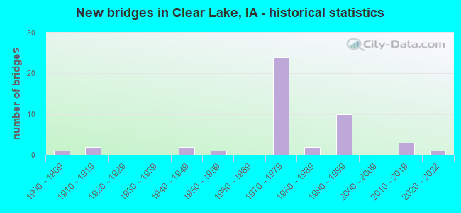
- New bridges - historical statistics
- 11900-1909
- 21910-1919
- 21940-1949
- 11950-1959
- 241970-1979
- 21980-1989
- 101990-1999
- 32010-2019
- 12020-2022
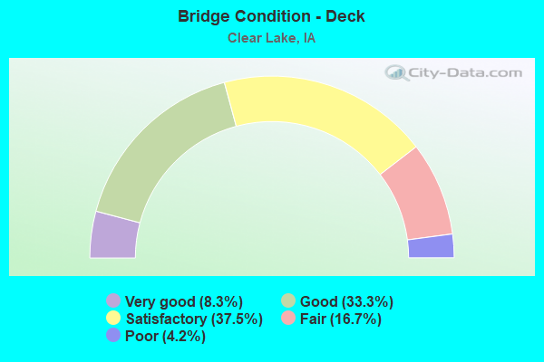
- Bridge Condition - Deck
- 8.3%Very good
- 33.3%Good
- 37.5%Satisfactory
- 16.7%Fair
- 4.2%Poor
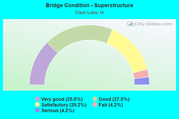
- Bridge Condition - Superstructure
- 25.0%Very good
- 37.5%Good
- 29.2%Satisfactory
- 4.2%Fair
- 4.2%Serious
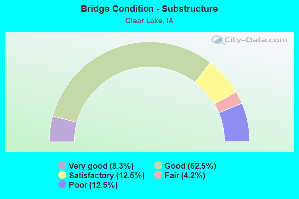
- Bridge Condition - Substructure
- 8.3%Very good
- 62.5%Good
- 12.5%Satisfactory
- 4.2%Fair
- 12.5%Poor
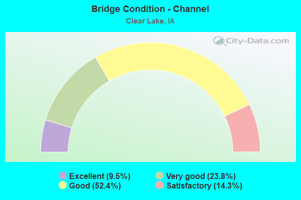
- Bridge Condition - Channel
- 9.5%Excellent
- 23.8%Very good
- 52.4%Good
- 14.3%Satisfactory
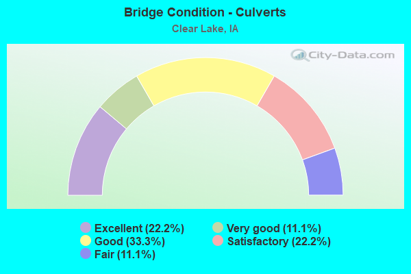
- Bridge Condition - Culverts
- 22.2%Excellent
- 11.1%Very good
- 33.3%Good
- 22.2%Satisfactory
- 11.1%Fair
Find on map >> Show street view
Structure Number: 1874, Location: 0.3 MI. W OF Jct. I-35 (Lat: 43.145194, Lng: -93.361800), Route carried "on" structure: US 18, Year Built: 1952, Year Reconstructed: 1969, Status: Open, Structure Length: 1.07m (3.51ft), Average Daily Traffic: 12,800 (year 2020), Truck Traffic: 7%, Average Future Daily Traffic: 12,800 (year 2040), Design Load: H 20, Features Intersected: WILLOW CREEK
Minimum Vertical Clearance: 30+ m (98+ ft), Kilometerpoint: 281.796, Lanes on structure: 6, Base Highway Network: Yes, Owner: State Highway Agency, Approaching Roadway Width: 21.9m (71.9ft), Skew: 24 degrees, Material/Design: Concrete continuous, Design/Construction: Culvert, Number Of Spans In Main Unit: 2, Length of Maximum Span: 5.2m (17.1ft)
Condition: Channel: Good, Culverts: Satisfactory, Operating Rating: 24.5 metric tons, Method Used To Determine Operating Rating: Field evaluation and documented engineering judgment, Inventory Rating: 18.1 metric tons, Method Used To Determine Inventory Rating: Field evaluation and documented engineering judgment, Structural Evaluation: Meets minimum limits, Waterway Adequacy: Equal to present minimum criteria, Approach Roadway Alignment: Equal to present desirable criteria, Designated Inspection Frequency: Every 24 months, Inspection Date: April 2020
Find on map >> Show street view
Structure Number: 19131, Location: 095210704 (Lat: 43.061797, Lng: -93.378758), Route carried "on" structure: County highway , Year Built: 1986, Status: Open, Structure Length: 0.98m (3.22ft), Average Daily Traffic: 830 (year 2021), Truck Traffic: 17%, Average Future Daily Traffic: 830 (year 2040), Design Load: HS 20, Features Intersected: BEAVER DAM CREEK, Facility Carried by Structure: S25 GROUSE AVE
Minimum Vertical Clearance: 30+ m (98+ ft), Kilometerpoint: 15.479, Lanes on structure: 2, Owner: County Highway Agency, Approaching Roadway Width: 6.7m (22.0ft), Skew: 4 degrees, Material/Design: Concrete continuous, Design/Construction: Culvert, Number Of Spans In Main Unit: 2, Length of Maximum Span: 4.6m (15.1ft)
Condition: Channel: Good, Culverts: Satisfactory, Operating Rating: 44.0 metric tons, Method Used To Determine Operating Rating: Field evaluation and documented engineering judgment, Inventory Rating: 32.3 metric tons, Method Used To Determine Inventory Rating: Field evaluation and documented engineering judgment, Structural Evaluation: Equal to present minimum criteria, Waterway Adequacy: Equal to present minimum criteria, Approach Roadway Alignment: Equal to present desirable criteria, Designated Inspection Frequency: Every 24 months, Inspection Date: Febuary 2020
Find on map >> Show street view
Structure Number: 1916, Location: 0.9 MI. S OF N JCT. US 18 (Lat: 43.133325, Lng: -93.355894), Route carried "on" structure: Interstate 35, Year Built: 1970, Status: Open, Structure Length: 7.01m (23.00ft), Average Daily Traffic: 8,150 (year 2020), Truck Traffic: 37%, Average Future Daily Traffic: 8,150 (year 2040), Design Load: HS 20, Features Intersected: 4TH AVE S
Minimum Vertical Clearance: 30+ m (98+ ft), Kilometerpoint: 310.872, Lanes on structure: 2, Lanes under structure: 4, Base Highway Network: Yes, Owner: State Highway Agency, Approaching Roadway Width: 12.2m (40.0ft), Material/Design: Steel continuous, Design/Construction: Stringer/Multi-beam, Number Of Spans In Main Unit: 3, Length of Maximum Span: 33.8m (110.9ft), Curb-To-Curb Width: 12.2m (40.0ft), Out-to-Out Width: 13.2m (43.3ft)
Condition: Deck: Fair, Superstructure: Satisfactory, Substructure: Good, Operating Rating: 61.7 metric tons, Method Used To Determine Operating Rating: Load Factor (LF), Inventory Rating: 36.9 metric tons, Method Used To Determine Inventory Rating: Load Factor (LF), Structural Evaluation: Equal to present minimum criteria, Deck Geometry: Better than present minimum criteria, Underclear: Better than present minimum criteria, Approach Roadway Alignment: Equal to present desirable criteria, Designated Inspection Frequency: Every 24 months, Inspection Date: April 2020, Deck Structure Type: Concrete Cast-file-Place, Wearing Surface/Protective System: Wearing Surface: Low Slump Concrete
Find on map >> Show street view
Structure Number: 1917, Location: 0.9 MI. S OF N JCT. US 18 (Lat: 43.134039, Lng: -93.356258), Route carried "on" structure: Interstate 35, Year Built: 1970, Status: Open, Structure Length: 7.01m (23.00ft), Average Daily Traffic: 8,150 (year 2020), Truck Traffic: 37%, Average Future Daily Traffic: 8,150 (year 2040), Design Load: HS 20, Features Intersected: 4TH AVE S
Minimum Vertical Clearance: 30+ m (98+ ft), Kilometerpoint: 40.742, Lanes on structure: 2, Lanes under structure: 4, Owner: State Highway Agency, Approaching Roadway Width: 12.2m (40.0ft), Material/Design: Steel continuous, Design/Construction: Stringer/Multi-beam, Number Of Spans In Main Unit: 3, Length of Maximum Span: 33.8m (110.9ft), Curb-To-Curb Width: 12.2m (40.0ft), Out-to-Out Width: 13.2m (43.3ft)
Condition: Deck: Fair, Superstructure: Satisfactory, Substructure: Satisfactory, Operating Rating: 67.5 metric tons, Method Used To Determine Operating Rating: Load Factor (LF), Inventory Rating: 40.5 metric tons, Method Used To Determine Inventory Rating: Load Factor (LF), Structural Evaluation: Equal to present minimum criteria, Deck Geometry: Better than present minimum criteria, Underclear: Better than present minimum criteria, Approach Roadway Alignment: Equal to present desirable criteria, Designated Inspection Frequency: Every 24 months, Inspection Date: April 2020, Deck Structure Type: Concrete Cast-file-Place, Wearing Surface/Protective System: Wearing Surface: Low Slump Concrete
Find on map >> Show street view
Structure Number: 1918, Location: 0.6 MI. S OF N JCT. US.18 (Lat: 43.137019, Lng: -93.355806), Route carried "on" structure: Interstate 35, Year Built: 1970, Status: Open, Structure Length: 6.61m (21.69ft), Average Daily Traffic: 8,150 (year 2020), Truck Traffic: 37%, Average Future Daily Traffic: 8,150 (year 2042), Design Load: HS 20+Mod, Features Intersected: MAIN ST
Minimum Vertical Clearance: 30+ m (98+ ft), Kilometerpoint: 311.283, Lanes on structure: 3, Lanes under structure: 2, Base Highway Network: Yes, Owner: State Highway Agency, Approaching Roadway Width: 17.4m (57.1ft), Material/Design: Prestressed concrete, Design/Construction: Stringer/Multi-beam, Number Of Spans In Main Unit: 3, Length of Maximum Span: 25.0m (82.0ft), Curb-To-Curb Width: 17.4m (57.1ft), Out-to-Out Width: 18.4m (60.4ft)
Condition: Deck: Good, Superstructure: Good, Substructure: Good, Operating Rating: 74.5 metric tons, Method Used To Determine Operating Rating: Load Factor (LF), Inventory Rating: 44.5 metric tons, Method Used To Determine Inventory Rating: Load Factor (LF), Structural Evaluation: Better than present minimum criteria, Deck Geometry: Better than present minimum criteria, Underclear: Superior to present desirable criteria, Approach Roadway Alignment: Equal to present desirable criteria, Designated Inspection Frequency: Every 24 months, Inspection Date: Febuary 2022, Deck Structure Type: Concrete Cast-file-Place, Wearing Surface/Protective System: Wearing Surface: Low Slump Concrete
Find on map >> Show street view
Structure Number: 1919, Location: 0.6 MI. S OF N JCT. US.18 (Lat: 43.137581, Lng: -93.356219), Route carried "on" structure: Interstate 35, Year Built: 1970, Status: Open, Structure Length: 6.61m (21.69ft), Average Daily Traffic: 9,300 (year 2020), Truck Traffic: 37%, Average Future Daily Traffic: 9,300 (year 2042), Design Load: HS 20+Mod, Features Intersected: MAIN ST
Minimum Vertical Clearance: 30+ m (98+ ft), Kilometerpoint: 40.348, Lanes on structure: 2, Lanes under structure: 2, Owner: State Highway Agency, Approaching Roadway Width: 15.9m (52.2ft), Material/Design: Prestressed concrete, Design/Construction: Stringer/Multi-beam, Number Of Spans In Main Unit: 3, Length of Maximum Span: 25.0m (82.0ft), Curb-To-Curb Width: 16.0m (52.5ft), Out-to-Out Width: 17.0m (55.8ft)
Condition: Deck: Satisfactory, Superstructure: Good, Substructure: Good, Operating Rating: 68.8 metric tons, Method Used To Determine Operating Rating: Load Factor (LF), Inventory Rating: 41.2 metric tons, Method Used To Determine Inventory Rating: Load Factor (LF), Structural Evaluation: Better than present minimum criteria, Deck Geometry: Superior to present desirable criteria, Underclear: Superior to present desirable criteria, Approach Roadway Alignment: Equal to present desirable criteria, Designated Inspection Frequency: Every 24 months, Inspection Date: Febuary 2022, Deck Structure Type: Concrete Cast-file-Place, Wearing Surface/Protective System: Wearing Surface: Low Slump Concrete
Find on map >> Show street view
Structure Number: 192, Location: 0.2 MI. S OF JCT. 18 (Lat: 43.141019, Lng: -93.355731), Route carried "on" structure: Interstate 35, Year Built: 1970, Status: Open, Structure Length: 5.46m (17.91ft), Average Daily Traffic: 9,300 (year 2020), Truck Traffic: 37%, Average Future Daily Traffic: 9,300 (year 2042), Design Load: HS 20, Features Intersected: IMRL RR
Minimum Vertical Clearance: 30+ m (98+ ft), Kilometerpoint: 311.727, Lanes on structure: 3, Base Highway Network: Yes, Owner: State Highway Agency, Approaching Roadway Width: 12.2m (40.0ft), Material/Design: Prestressed concrete, Design/Construction: Stringer/Multi-beam, Number Of Spans In Main Unit: 3, Length of Maximum Span: 21.0m (68.9ft), Curb-To-Curb Width: 15.9m (52.2ft), Out-to-Out Width: 16.9m (55.4ft)
Condition: Deck: Satisfactory, Superstructure: Good, Substructure: Good, Operating Rating: 61.7 metric tons, Method Used To Determine Operating Rating: Load Factor (LF), Inventory Rating: 36.9 metric tons, Method Used To Determine Inventory Rating: Load Factor (LF), Structural Evaluation: Better than present minimum criteria, Deck Geometry: Somewhat better than minimum adequacy, Underclear: Superior to present desirable criteria, Approach Roadway Alignment: Better than present minimum criteria, Designated Inspection Frequency: Every 24 months, Inspection Date: Febuary 2022, Deck Structure Type: Concrete Cast-file-Place, Wearing Surface/Protective System: Wearing Surface: Low Slump Concrete
Find on map >> Show street view
Structure Number: 1921, Location: 0.2 MI. S OF JCT. 18 (Lat: 43.141517, Lng: -93.356144), Route carried "on" structure: Interstate 35, Year Built: 1970, Status: Open, Structure Length: 5.46m (17.91ft), Average Daily Traffic: 9,300 (year 2020), Truck Traffic: 37%, Average Future Daily Traffic: 9,300 (year 2042), Design Load: HS 20, Features Intersected: IMRL RR
Minimum Vertical Clearance: 30+ m (98+ ft), Kilometerpoint: 39.912, Lanes on structure: 3, Owner: State Highway Agency, Approaching Roadway Width: 16.2m (53.1ft), Material/Design: Prestressed concrete, Design/Construction: Stringer/Multi-beam, Number Of Spans In Main Unit: 3, Length of Maximum Span: 21.0m (68.9ft), Curb-To-Curb Width: 16.3m (53.5ft), Out-to-Out Width: 17.4m (57.1ft)
Condition: Deck: Good, Superstructure: Good, Substructure: Very good, Operating Rating: 60.9 metric tons, Method Used To Determine Operating Rating: Load Factor (LF), Inventory Rating: 36.6 metric tons, Method Used To Determine Inventory Rating: Load Factor (LF), Structural Evaluation: Better than present minimum criteria, Deck Geometry: Equal to present minimum criteria, Underclear: Better than present minimum criteria, Approach Roadway Alignment: Better than present minimum criteria, Designated Inspection Frequency: Every 24 months, Inspection Date: Febuary 2022, Deck Structure Type: Concrete Cast-file-Place, Wearing Surface/Protective System: Wearing Surface: Low Slump Concrete
Find on map >> Show street view
Structure Number: 105901, Location: 095210902 (Lat: 43.059556, Lng: -93.339825), Route carried "on" structure: County highway , Year Built: 1998, Status: Open, Structure Length: 0.73m (2.40ft), Average Daily Traffic: 80 (year 2013), Average Future Daily Traffic: 80 (year 2040), Design Load: HS 20+Mod, Features Intersected: BEAVER DAM CREEK, Facility Carried by Structure: INDIGO
Minimum Vertical Clearance: 30+ m (98+ ft), Kilometerpoint: 12.118, Lanes on structure: 2, Owner: County Highway Agency, Approaching Roadway Width: 14.6m (47.9ft), Skew: 1 degrees, Material/Design: Concrete, Design/Construction: Culvert, Number Of Spans In Main Unit: 2, Length of Maximum Span: 4.0m (13.1ft)
Condition: Channel: Good, Culverts: Good, Operating Rating: 42.2 metric tons, Method Used To Determine Operating Rating: Field evaluation and documented engineering judgment, Inventory Rating: 32.7 metric tons, Method Used To Determine Inventory Rating: Field evaluation and documented engineering judgment, Structural Evaluation: Better than present minimum criteria, Waterway Adequacy: Equal to present desirable criteria, Approach Roadway Alignment: Equal to present desirable criteria, Designated Inspection Frequency: Every 24 months, Inspection Date: Febuary 2020
Find on map >> Show street view
Structure Number: 10631, Location: 096210603 (Lat: 43.162719, Lng: -93.374061), Route carried "on" structure: County highway , Year Built: 1941, Status: Open, Structure Length: 1.98m (6.50ft), Average Daily Traffic: 90 (year 2013), Average Future Daily Traffic: 90 (year 2040), Features Intersected: WILLOW CREEK, Facility Carried by Structure: 275TH
Minimum Vertical Clearance: 30+ m (98+ ft), Kilometerpoint: 7.437, Lanes on structure: 2, Owner: County Highway Agency, Approaching Roadway Width: 7.9m (25.9ft), Skew: 3 degrees, Material/Design: Steel, Design/Construction: Stringer/Multi-beam, Number Of Spans In Main Unit: 3, Length of Maximum Span: 6.4m (21.0ft), Curb-To-Curb Width: 6.1m (20.0ft), Out-to-Out Width: 6.6m (21.7ft)
Condition: Deck: Fair, Superstructure: Good, Substructure: Poor, Channel: Very good, Operating Rating: 44.7 metric tons, Method Used To Determine Operating Rating: Load Factor (LF), Inventory Rating: 25.4 metric tons, Method Used To Determine Inventory Rating: Load Factor (LF), Structural Evaluation: Meets minimum limits, Deck Geometry: Somewhat better than minimum adequacy, Waterway Adequacy: Equal to present desirable criteria, Approach Roadway Alignment: Equal to present desirable criteria, Length Of Structure Improvement: 8.90m (29.20ft), Designated Inspection Frequency: Every 24 months, Inspection Date: January 2020, Bridge Improvement Cost: $192,000, Roadway Improvement Cost: $29,000, Deck Structure Type: Concrete Cast-file-Place, Wearing Surface/Protective System: Wearing Surface: Gravel
Find on map >> Show street view
Structure Number: 10632, Location: 096210900 (Lat: 43.147642, Lng: -93.339728), Route carried "on" structure: City street , Year Built: 1970, Status: Open, Structure Length: 2.44m (8.01ft), Average Daily Traffic: 890 (year 1997), Average Future Daily Traffic: 890 (year 2040), Design Load: HS 20, Features Intersected: WILLOW CREEK, Facility Carried by Structure: N 40TH ST
Minimum Vertical Clearance: 30+ m (98+ ft), Kilometerpoint: 1.133, Lanes on structure: 2, Owner: City or Municipal Highway Agency, Approaching Roadway Width: 10.4m (34.1ft), Material/Design: Concrete continuous, Design/Construction: Slab, Number Of Spans In Main Unit: 3, Length of Maximum Span: 9.4m (30.8ft), Curb-To-Curb Width: 13.4m (44.0ft), Out-to-Out Width: 14.4m (47.2ft)
Condition: Deck: Satisfactory, Superstructure: Satisfactory, Substructure: Good, Channel: Satisfactory, Operating Rating: 65.6 metric tons, Method Used To Determine Operating Rating: Load Factor (LF), Inventory Rating: 39.3 metric tons, Method Used To Determine Inventory Rating: Load Factor (LF), Structural Evaluation: Equal to present minimum criteria, Deck Geometry: Superior to present desirable criteria, Waterway Adequacy: Equal to present desirable criteria, Approach Roadway Alignment: Better than present minimum criteria, Designated Inspection Frequency: Every 24 months, Inspection Date: March 2020, Deck Structure Type: Concrete Cast-file-Place, Wearing Surface/Protective System: Wearing Surface: Monolithic Concrete
Find on map >> Show street view
Structure Number: 10633, Location: 092210900 (Lat: 43.141258, Lng: -93.321653), Route carried "on" structure: City street , Year Built: 1900, Status: Posted for load-capacity, Structure Length: 1.40m (4.59ft), Average Daily Traffic: 30 (year 2009), Average Future Daily Traffic: 30 (year 2040), Features Intersected: WILLOW CREEK, Facility Carried by Structure: E-W 7TH AVE N
Minimum Vertical Clearance: 30+ m (98+ ft), Kilometerpoint: 4.221, Lanes on structure: 1, Owner: City or Municipal Highway Agency, Approaching Roadway Width: 6.1m (20.0ft), Material/Design: Concrete, Design/Construction: Arch - Deck, Number Of Spans In Main Unit: 1, Length of Maximum Span: 13.7m (44.9ft), Curb-To-Curb Width: 4.7m (15.4ft), Out-to-Out Width: 5.8m (19.0ft)
Condition: Deck: Poor, Superstructure: Serious, Substructure: Poor, Channel: Satisfactory, Operating Rating: 34.1 metric tons, Method Used To Determine Operating Rating: Field evaluation and documented engineering judgment, Inventory Rating: 24.2 metric tons, Method Used To Determine Inventory Rating: Field evaluation and documented engineering judgment, Structural Evaluation: High priority of corrective action, Deck Geometry: Better than present minimum criteria, Waterway Adequacy: Equal to present minimum criteria, Approach Roadway Alignment: Better than present minimum criteria, Length Of Structure Improvement: 6.80m (22.31ft), Designated Inspection Frequency: Every 24 months, Inspection Date: March 2020, Bridge Improvement Cost: $176,000, Roadway Improvement Cost: $35,000
Find on map >> Show street view
Structure Number: 106355, Location: 096211404 (Lat: 43.127767, Lng: -93.300297), Route carried "on" structure: County highway , Year Built: 1973, Status: Open, Structure Length: 0.79m (2.59ft), Average Daily Traffic: 350 (year 2013), Truck Traffic: 46%, Average Future Daily Traffic: 350 (year 2040), Features Intersected: CRANE CREEK, Facility Carried by Structure: KILLDEER
Minimum Vertical Clearance: 30+ m (98+ ft), Kilometerpoint: 18.895, Lanes on structure: 2, Owner: County Highway Agency, Approaching Roadway Width: 8.5m (27.9ft), Skew: 4 degrees, Material/Design: Concrete, Design/Construction: Culvert, Number Of Spans In Main Unit: 2, Length of Maximum Span: 3.7m (12.1ft)
Condition: Channel: Good, Culverts: Fair, Operating Rating: 34.1 metric tons, Method Used To Determine Operating Rating: Field evaluation and documented engineering judgment, Inventory Rating: 24.2 metric tons, Method Used To Determine Inventory Rating: Field evaluation and documented engineering judgment, Structural Evaluation: Somewhat better than minimum adequacy, Waterway Adequacy: Equal to present desirable criteria, Approach Roadway Alignment: Better than present minimum criteria, Length Of Structure Improvement: 4.60m (15.09ft), Designated Inspection Frequency: Every 24 months, Inspection Date: January 2020, Bridge Improvement Cost: $69,000, Roadway Improvement Cost: $7,000
Find on map >> Show street view
Structure Number: 106361, Location: 096211504 (Lat: 43.139133, Lng: -93.320064), Route carried "on" structure: County highway , Year Built: 1997, Status: Open, Structure Length: 1.46m (4.79ft), Average Daily Traffic: 560 (year 2013), Truck Traffic: 16%, Average Future Daily Traffic: 560 (year 2040), Design Load: HS 20, Features Intersected: WILLOW CREEK, Facility Carried by Structure: JONQUIL
Minimum Vertical Clearance: 30+ m (98+ ft), Kilometerpoint: 25.695, Lanes on structure: 2, Owner: County Highway Agency, Approaching Roadway Width: 7.3m (24.0ft), Material/Design: Concrete, Design/Construction: Culvert, Number Of Spans In Main Unit: 2, Length of Maximum Span: 7.3m (24.0ft)
Condition: Channel: Satisfactory, Culverts: Good, Operating Rating: 60.0 metric tons, Method Used To Determine Operating Rating: Load Factor (LF), Inventory Rating: 35.9 metric tons, Method Used To Determine Inventory Rating: Load Factor (LF), Structural Evaluation: Better than present minimum criteria, Waterway Adequacy: Superior to present desirable criteria, Approach Roadway Alignment: Equal to present desirable criteria, Designated Inspection Frequency: Every 24 months, Inspection Date: January 2020
Find on map >> Show street view
Structure Number: 10638, Location: 096212203 (Lat: 43.126444, Lng: -93.301778), Route carried "on" structure: County highway , Year Built: 1941, Status: Open, Structure Length: 1.16m (3.81ft), Average Daily Traffic: 30 (year 2013), Average Future Daily Traffic: 30 (year 2040), Design Load: H 15, Features Intersected: CRANE CR, Facility Carried by Structure: 250TH
Minimum Vertical Clearance: 30+ m (98+ ft), Kilometerpoint: 3.595, Lanes on structure: 2, Owner: County Highway Agency, Approaching Roadway Width: 9.1m (29.9ft), Skew: 3 degrees, Material/Design: Steel, Design/Construction: Stringer/Multi-beam, Number Of Spans In Main Unit: 1, Length of Maximum Span: 11.6m (38.1ft), Curb-To-Curb Width: 6.1m (20.0ft), Out-to-Out Width: 6.5m (21.3ft)
Condition: Deck: Fair, Superstructure: Satisfactory, Substructure: Fair, Channel: Good, Operating Rating: 36.7 metric tons, Method Used To Determine Operating Rating: Load Factor (LF), Inventory Rating: 21.9 metric tons, Method Used To Determine Inventory Rating: Load Factor (LF), Structural Evaluation: Somewhat better than minimum adequacy, Deck Geometry: Somewhat better than minimum adequacy, Waterway Adequacy: Equal to present desirable criteria, Approach Roadway Alignment: Equal to present desirable criteria, Length Of Structure Improvement: 6.00m (19.69ft), Designated Inspection Frequency: Every 24 months, Inspection Date: January 2020, Bridge Improvement Cost: $129,000, Roadway Improvement Cost: $19,000, Deck Structure Type: Concrete Cast-file-Place, Wearing Surface/Protective System: Wearing Surface: Other
Find on map >> Show street view
Structure Number: 1064, Location: 096220104 (Lat: 43.167614, Lng: -93.388761), Route carried "on" structure: County highway , Year Built: 1918, Status: Posted for load, Structure Length: 1.01m (3.31ft), Average Daily Traffic: 80 (year 2013), Average Future Daily Traffic: 80 (year 2040), Features Intersected: WILLOW CREEK, Facility Carried by Structure: FIR
Minimum Vertical Clearance: 30+ m (98+ ft), Kilometerpoint: 7.520, Lanes on structure: 2, Owner: County Highway Agency, Approaching Roadway Width: 10.4m (34.1ft), Skew: 3 degrees, Material/Design: Concrete, Design/Construction: Stringer/Multi-beam, Number Of Spans In Main Unit: 1, Length of Maximum Span: 10.1m (33.1ft), Curb-To-Curb Width: 6.8m (22.3ft), Out-to-Out Width: 7.4m (24.3ft)
Condition: Deck: Satisfactory, Superstructure: Satisfactory, Substructure: Satisfactory, Channel: Good, Operating Rating: 32.3 metric tons, Method Used To Determine Operating Rating: Field evaluation and documented engineering judgment, Inventory Rating: 17.1 metric tons, Method Used To Determine Inventory Rating: Field evaluation and documented engineering judgment, Structural Evaluation: Somewhat better than minimum adequacy, Deck Geometry: Somewhat better than minimum adequacy, Waterway Adequacy: Equal to present desirable criteria, Approach Roadway Alignment: Equal to present desirable criteria, Bridge Posting: Required (Relationship of Operating Rating to Maximum Legal Load: 0.1 - 9.9% below), Length Of Structure Improvement: 5.50m (18.04ft), Designated Inspection Frequency: Every 24 months, Inspection Date: January 2020, Bridge Improvement Cost: $119,000, Roadway Improvement Cost: $18,000, Deck Structure Type: Concrete Cast-file-Place, Wearing Surface/Protective System: Wearing Surface: Gravel
Find on map >> Show street view
Structure Number: 10685, Location: 097212004 (Lat: 43.209447, Lng: -93.349564), Route carried "on" structure: County highway , Year Built: 1917, Status: Posted for load, Structure Length: 0.76m (2.49ft), Average Daily Traffic: 60 (year 2021), Average Future Daily Traffic: 60 (year 2040), Features Intersected: CALMUS CREEK, Facility Carried by Structure: HICKORY AVE
Minimum Vertical Clearance: 30+ m (98+ ft), Kilometerpoint: 7.829, Lanes on structure: 2, Owner: County Highway Agency, Approaching Roadway Width: 9.8m (32.2ft), Skew: 2 degrees, Material/Design: Concrete, Design/Construction: Stringer/Multi-beam, Number Of Spans In Main Unit: 1, Length of Maximum Span: 7.3m (24.0ft), Curb-To-Curb Width: 6.2m (20.3ft), Out-to-Out Width: 6.9m (22.6ft)
Condition: Deck: Satisfactory, Superstructure: Fair, Substructure: Poor, Channel: Good, Operating Rating: 31.5 metric tons, Method Used To Determine Operating Rating: Field evaluation and documented engineering judgment, Inventory Rating: 17.1 metric tons, Method Used To Determine Inventory Rating: Field evaluation and documented engineering judgment, Structural Evaluation: Meets minimum limits, Deck Geometry: Somewhat better than minimum adequacy, Waterway Adequacy: Better than present minimum criteria, Approach Roadway Alignment: Equal to present desirable criteria, Bridge Posting: Required (Relationship of Operating Rating to Maximum Legal Load: 20.0 - 29.9% below), Length Of Structure Improvement: 4.60m (15.09ft), Designated Inspection Frequency: Every 24 months, Inspection Date: January 2020, Bridge Improvement Cost: $99,000, Roadway Improvement Cost: $15,000, Deck Structure Type: Concrete Cast-file-Place, Wearing Surface/Protective System: Wearing Surface: Gravel
Find on map >> Show street view
Structure Number: 106861, Location: Indigo 745 N of 300th (Lat: 43.200761, Lng: -93.339792), Route carried "on" structure: County highway , Year Built: 2020, Status: Open, Structure Length: 0.80m (2.62ft), Average Daily Traffic: 35 (year 2013), Average Future Daily Traffic: 35 (year 2040), Design Load: HL 93, Features Intersected: CALMUS CREEK, Facility Carried by Structure: INDIGO AVE
Minimum Vertical Clearance: 30+ m (98+ ft), Kilometerpoint: 20.418, Lanes on structure: 2, Owner: County Highway Agency, Approaching Roadway Width: 9.8m (32.2ft), Material/Design: Concrete, Design/Construction: Culvert, Number Of Spans In Main Unit: 2, Length of Maximum Span: 3.7m (12.1ft), Curb-To-Curb Width: 10.7m (35.1ft), Out-to-Out Width: 11.0m (36.1ft)
Condition: Channel: Excellent, Culverts: Excellent, Operating Rating: 58.3 metric tons, Method Used To Determine Operating Rating: Load and Resistance Factor Rating (LRFR) rating reported by rating factor(RF) method using HL-93 loadings, Inventory Rating: 45.0 metric tons, Method Used To Determine Inventory Rating: Load and Resistance Factor Rating (LRFR) rating reported by rating factor(RF) method using HL-93 loadings, Structural Evaluation: Superior to present desirable criteria, Deck Geometry: Superior to present desirable criteria, Waterway Adequacy: Superior to present desirable criteria, Approach Roadway Alignment: Superior to present desirable criteria, Designated Inspection Frequency: Every 24 months, Inspection Date: July 2020, Wearing Surface/Protective System: Wearing Surface: Gravel
Find on map >> Show street view
Structure Number: 106971, Location: 097223406 (Lat: 43.172406, Lng: -93.428481), Route carried "on" structure: County highway , Year Built: 1982, Status: Open, Structure Length: 3.11m (10.20ft), Average Daily Traffic: 45 (year 2013), Average Future Daily Traffic: 45 (year 2040), Design Load: H 20, Features Intersected: WILLOW CREEK, Facility Carried by Structure: DOVE
Minimum Vertical Clearance: 30+ m (98+ ft), Kilometerpoint: 3.484, Lanes on structure: 2, Owner: County Highway Agency, Approaching Roadway Width: 9.1m (29.9ft), Skew: 4 degrees, Material/Design: Concrete continuous, Design/Construction: Slab, Number Of Spans In Main Unit: 3, Length of Maximum Span: 11.9m (39.0ft), Curb-To-Curb Width: 9.1m (29.9ft), Out-to-Out Width: 10.1m (33.1ft)
Condition: Deck: Very good, Superstructure: Very good, Substructure: Good, Channel: Very good, Operating Rating: 56.6 metric tons, Method Used To Determine Operating Rating: Allowable Stress (AS), Inventory Rating: 32.7 metric tons, Method Used To Determine Inventory Rating: Allowable Stress (AS), Structural Evaluation: Better than present minimum criteria, Deck Geometry: Better than present minimum criteria, Waterway Adequacy: Superior to present desirable criteria, Approach Roadway Alignment: Superior to present desirable criteria, Designated Inspection Frequency: Every 24 months, Inspection Date: January 2020, Deck Structure Type: Concrete Cast-file-Place, Wearing Surface/Protective System: Wearing Surface: Monolithic Concrete
Find on map >> Show street view
Structure Number: 106982, Location: 097223504 (Lat: 43.171300, Lng: -93.418522), Route carried "on" structure: County highway , Year Built: 2019, Status: Open, Structure Length: 0.63m (2.07ft), Average Daily Traffic: 740 (year 2021), Truck Traffic: 11%, Average Future Daily Traffic: 740 (year 2040), Design Load: HL 93, Features Intersected: WILLOW CREEK, Facility Carried by Structure: S18 EAGLE AVE
Minimum Vertical Clearance: 30+ m (98+ ft), Kilometerpoint: 16.744, Lanes on structure: 2, Owner: County Highway Agency, Approaching Roadway Width: 8.5m (27.9ft), Material/Design: Concrete, Design/Construction: Culvert, Number Of Spans In Main Unit: 2, Length of Maximum Span: 3.0m (9.8ft)
Condition: Channel: Excellent, Culverts: Excellent, Operating Rating: 50.5 metric tons, Method Used To Determine Operating Rating: Load and Resistance Factor Rating (LRFR) rating reported by rating factor(RF) method using HL-93 loadings, Inventory Rating: 39.2 metric tons, Method Used To Determine Inventory Rating: Load and Resistance Factor Rating (LRFR) rating reported by rating factor(RF) method using HL-93 loadings, Structural Evaluation: Superior to present desirable criteria, Waterway Adequacy: Equal to present desirable criteria, Approach Roadway Alignment: Equal to present desirable criteria, Designated Inspection Frequency: Every 24 months, Inspection Date: January 2020
Find on map >> Show street view
Structure Number: 362655, Location: 096221500 (Lat: 43.135758, Lng: -93.426503), Route carried "on" structure: City street , Year Built: 1972, Status: Open, Structure Length: 1.68m (5.51ft), Average Daily Traffic: 1,020 (year 2017), Average Future Daily Traffic: 1,020 (year 2040), Design Load: HS 20, Features Intersected: STREAM, Facility Carried by Structure: NO SHORE DR
Minimum Vertical Clearance: 30+ m (98+ ft), Kilometerpoint: 1.007, Lanes on structure: 2, Owner: City or Municipal Highway Agency, Approaching Roadway Width: 11.0m (36.1ft), Material/Design: Concrete continuous, Design/Construction: Slab, Number Of Spans In Main Unit: 3, Length of Maximum Span: 5.8m (19.0ft), Curb or Sidewalk Widths: Left: 1.2m (3.9ft), Right: 1.2m (3.9ft), Curb-To-Curb Width: 9.1m (29.9ft), Out-to-Out Width: 11.7m (38.4ft)
Condition: Deck: Satisfactory, Superstructure: Satisfactory, Substructure: Satisfactory, Channel: Good, Operating Rating: 63.8 metric tons, Method Used To Determine Operating Rating: Load Factor (LF), Inventory Rating: 38.2 metric tons, Method Used To Determine Inventory Rating: Load Factor (LF), Structural Evaluation: Equal to present minimum criteria, Deck Geometry: Somewhat better than minimum adequacy, Waterway Adequacy: Better than present minimum criteria, Approach Roadway Alignment: Equal to present desirable criteria, Designated Inspection Frequency: Every 24 months, Inspection Date: March 2020, Deck Structure Type: Concrete Cast-file-Place, Wearing Surface/Protective System: Wearing Surface: Bituminous
Find on map >> Show street view
Structure Number: 365835, Location: 0962134 (Lat: 43.097492, Lng: -93.310489), Route carried "on" structure: County highway , Year Built: 2012, Status: Open, Structure Length: 0.69m (2.26ft), Average Daily Traffic: 40 (year 2021), Average Future Daily Traffic: 40 (year 2040), Design Load: HS 20, Features Intersected: CRANE CREEK, Facility Carried by Structure: 230TH ST
Minimum Vertical Clearance: 30+ m (98+ ft), Kilometerpoint: 12.022, Lanes on structure: 2, Owner: County Highway Agency, Approaching Roadway Width: 7.3m (24.0ft), Skew: 1 degrees, Material/Design: Concrete, Design/Construction: Culvert, Number Of Spans In Main Unit: 2, Length of Maximum Span: 3.0m (9.8ft)
Condition: Channel: Very good, Culverts: Very good, Operating Rating: 45.4 metric tons, Method Used To Determine Operating Rating: Load Factor (LF), Inventory Rating: 32.7 metric tons, Method Used To Determine Inventory Rating: Load Factor (LF), Structural Evaluation: Equal to present desirable criteria, Waterway Adequacy: Equal to present desirable criteria, Approach Roadway Alignment: Equal to present desirable criteria, Designated Inspection Frequency: Every 24 months, Inspection Date: January 2020
Find on map >> Show street view
Structure Number: 50427, Location: 096210700 (Lat: 43.147008, Lng: -93.364539), Route carried "on" structure: City street , Year Built: 1994, Status: Open, Structure Length: 5.24m (17.19ft), Average Daily Traffic: 830 (year 2021), Average Future Daily Traffic: 830 (year 2038), Design Load: HS 20, Features Intersected: WILLOW CREEK, Facility Carried by Structure: N 20TH ST(PROP)
Minimum Vertical Clearance: 30+ m (98+ ft), Kilometerpoint: 1.072, Lanes on structure: 2, Owner: City or Municipal Highway Agency, Approaching Roadway Width: 7.3m (24.0ft), Skew: 4 degrees, Material/Design: Concrete continuous, Design/Construction: Slab, Number Of Spans In Main Unit: 3, Length of Maximum Span: 20.1m (65.9ft), Curb-To-Curb Width: 9.1m (29.9ft), Out-to-Out Width: 11.9m (39.0ft)
Condition: Deck: Satisfactory, Superstructure: Satisfactory, Substructure: Good, Channel: Good, Operating Rating: 59.5 metric tons, Method Used To Determine Operating Rating: Load Factor (LF), Inventory Rating: 35.6 metric tons, Method Used To Determine Inventory Rating: Load Factor (LF), Structural Evaluation: Equal to present minimum criteria, Deck Geometry: Equal to present minimum criteria, Waterway Adequacy: Equal to present desirable criteria, Approach Roadway Alignment: Equal to present desirable criteria, Designated Inspection Frequency: Every 48 months, Inspection Date: April 2018, Deck Structure Type: Concrete Cast-file-Place, Wearing Surface/Protective System: Wearing Surface: Monolithic Concrete
Find on map >> Show street view
Structure Number: 505395, Location: 96211801 (Lat: 43.126517, Lng: -93.367411), Route carried "on" structure: City street , Year Built: 2016, Status: Open, Structure Length: 0.94m (3.08ft), Average Daily Traffic: 870 (year 2013), Average Future Daily Traffic: 870 (year 2040), Design Load: HL 93, Features Intersected: CLEAR CREEK, Facility Carried by Structure: 12TH AVE S
Minimum Vertical Clearance: 30+ m (98+ ft), Kilometerpoint: 1.231, Lanes on structure: 2, Owner: City or Municipal Highway Agency, Approaching Roadway Width: 9.4m (30.8ft), Skew: 3 degrees, Material/Design: Concrete, Design/Construction: Slab, Number Of Spans In Main Unit: 1, Length of Maximum Span: 9.1m (29.9ft), Curb-To-Curb Width: 9.1m (29.9ft), Out-to-Out Width: 10.1m (33.1ft)
Condition: Deck: Very good, Superstructure: Very good, Substructure: Very good, Channel: Very good, Operating Rating: 42.1 metric tons, Method Used To Determine Operating Rating: Assigned ratings based on Load and Resistance Factor Design (LRFD) reported by rating factor (RF) using HL93 loadings, Inventory Rating: 32.4 metric tons, Method Used To Determine Inventory Rating: Assigned ratings based on Load and Resistance Factor Design (LRFD) reported by rating factor (RF) using HL93 loadings, Structural Evaluation: Equal to present desirable criteria, Deck Geometry: Equal to present minimum criteria, Waterway Adequacy: Equal to present desirable criteria, Approach Roadway Alignment: Equal to present desirable criteria, Designated Inspection Frequency: Every 48 months, Inspection Date: March 2020, Deck Structure Type: Concrete Cast-file-Place, Wearing Surface/Protective System: Wearing Surface: Monolithic Concrete, Deck Protection: Epoxy Coated Reinforcing
Find on map >> Show street view
Structure Number: 601745, Location: 1.9 MI. E OF JCT. I-35 (Lat: 43.105178, Lng: -93.309619), Route carried "on" structure: US 18, Year Built: 1998, Status: Open, Structure Length: 0.64m (2.10ft), Average Daily Traffic: 8,000 (year 2020), Truck Traffic: 32%, Average Future Daily Traffic: 8,000 (year 2041), Design Load: HS 20, Features Intersected: CRANE CREEK
Minimum Vertical Clearance: 30+ m (98+ ft), Kilometerpoint: 291.171, Lanes on structure: 4, Base Highway Network: Yes, Owner: State Highway Agency, Approaching Roadway Width: 25.6m (84.0ft), Skew: 20 degrees, Material/Design: Concrete continuous, Design/Construction: Culvert, Number Of Spans In Main Unit: 2, Length of Maximum Span: 3.0m (9.8ft)
Condition: Channel: Very good, Culverts: Good, Operating Rating: 50.2 metric tons, Method Used To Determine Operating Rating: Load and Resistance Factor Rating (LRFR) rating reported by rating factor(RF) method using HL-93 loadings, Inventory Rating: 38.6 metric tons, Method Used To Determine Inventory Rating: Load and Resistance Factor Rating (LRFR) rating reported by rating factor(RF) method using HL-93 loadings, Structural Evaluation: Better than present minimum criteria, Waterway Adequacy: Equal to present desirable criteria, Approach Roadway Alignment: Equal to present desirable criteria, Designated Inspection Frequency: Every 24 months, Inspection Date: August 2021
Find on map >> Show street view
Structure Number: 601915, Location: 1.4 MI. E OF JCT. I-35 (Lat: 43.104550, Lng: -93.320003), Route carried "on" structure: County highway , Year Built: 1998, Status: Open, Structure Length: 7.13m (23.39ft), Average Daily Traffic: 50 (year 2013), Average Future Daily Traffic: 50 (year 2041), Design Load: HS 20, Features Intersected: US 18 RELOC., Facility Carried by Structure: JONQUIL AVE
Minimum Vertical Clearance: 30+ m (98+ ft), Kilometerpoint: 21.853, Lanes on structure: 2, Lanes under structure: 4, Owner: State Highway Agency, Approaching Roadway Width: 9.8m (32.2ft), Skew: 1 degrees, Material/Design: Prestressed concrete, Design/Construction: Stringer/Multi-beam, Number Of Spans In Main Unit: 2, Length of Maximum Span: 35.4m (116.1ft), Curb-To-Curb Width: 9.0m (29.5ft), Out-to-Out Width: 9.1m (29.9ft)
Condition: Deck: Good, Superstructure: Very good, Substructure: Good, Operating Rating: 89.8 metric tons, Method Used To Determine Operating Rating: Load Factor (LF), Inventory Rating: 56.9 metric tons, Method Used To Determine Inventory Rating: Load Factor (LF), Structural Evaluation: Better than present minimum criteria, Deck Geometry: Better than present minimum criteria, Underclear: Equal to present minimum criteria, Approach Roadway Alignment: Equal to present desirable criteria, Designated Inspection Frequency: Every 24 months, Inspection Date: October 2021, Deck Structure Type: Concrete Cast-file-Place, Wearing Surface/Protective System: Wearing Surface: Monolithic Concrete, Deck Protection: Epoxy Coated Reinforcing
Find on map >> Show street view
Structure Number: 60197, Location: AT THE JCT. OF I-35 (Lat: 43.098769, Lng: -93.346383), Route carried "on" structure: US 18, Year Built: 1998, Status: Open, Structure Length: 11.98m (39.30ft), Average Daily Traffic: 1,380 (year 2020), Truck Traffic: 47%, Average Future Daily Traffic: 1,380 (year 2041), Design Load: HS 20, Features Intersected: I-35
Minimum Vertical Clearance: 30+ m (98+ ft), Kilometerpoint: 288.074, Lanes on structure: 1, Lanes under structure: 5, Base Highway Network: Yes, Owner: State Highway Agency, Approaching Roadway Width: 11.3m (37.1ft), Material/Design: Prestressed concrete, Design/Construction: Stringer/Multi-beam, Number Of Spans In Main Unit: 4, Length of Maximum Span: 30.8m (101.0ft), Curb-To-Curb Width: 11.4m (37.4ft), Out-to-Out Width: 12.4m (40.7ft)
Condition: Deck: Good, Superstructure: Very good, Substructure: Good, Operating Rating: 75.5 metric tons, Method Used To Determine Operating Rating: Load Factor (LF), Inventory Rating: 37.4 metric tons, Method Used To Determine Inventory Rating: Load Factor (LF), Structural Evaluation: Better than present minimum criteria, Deck Geometry: Equal to present minimum criteria, Underclear: Somewhat better than minimum adequacy, Approach Roadway Alignment: Equal to present desirable criteria, Designated Inspection Frequency: Every 24 months, Inspection Date: January 2021, Deck Structure Type: Concrete Cast-file-Place, Wearing Surface/Protective System: Wearing Surface: Monolithic Concrete, Deck Protection: Epoxy Coated Reinforcing
Find on map >> Show street view
Structure Number: 601975, Location: AT THE JCT. OF I-35 (Lat: 43.099772, Lng: -93.345111), Route carried "on" structure: Interstate 35, Year Built: 1998, Status: Open, Structure Length: 12.22m (40.09ft), Average Daily Traffic: 505 (year 2020), Truck Traffic: 28%, Average Future Daily Traffic: 505 (year 2041), Design Load: HS 20, Features Intersected: I-35, Facility Carried by Structure: US 18 WB
Minimum Vertical Clearance: 30+ m (98+ ft), Kilometerpoint: 0.697, Lanes on structure: 1, Lanes under structure: 6, Owner: State Highway Agency, Approaching Roadway Width: 11.3m (37.1ft), Material/Design: Prestressed concrete, Design/Construction: Stringer/Multi-beam, Number Of Spans In Main Unit: 4, Length of Maximum Span: 32.3m (106.0ft), Curb-To-Curb Width: 11.4m (37.4ft), Out-to-Out Width: 12.3m (40.4ft)
Condition: Deck: Good, Superstructure: Very good, Substructure: Good, Operating Rating: 73.5 metric tons, Method Used To Determine Operating Rating: Load Factor (LF), Inventory Rating: 44.4 metric tons, Method Used To Determine Inventory Rating: Load Factor (LF), Structural Evaluation: Better than present minimum criteria, Deck Geometry: Better than present minimum criteria, Underclear: Equal to present minimum criteria, Approach Roadway Alignment: Equal to present desirable criteria, Designated Inspection Frequency: Every 24 months, Inspection Date: January 2021, Deck Structure Type: Concrete Cast-file-Place, Wearing Surface/Protective System: Wearing Surface: Monolithic Concrete, Deck Protection: Epoxy Coated Reinforcing
Find on map >> Show street view
Structure Number: 60232, Location: 0.6 MI. S OF JCT. SR B43 (Lat: 43.059508, Lng: -93.342350), Route carried "on" structure: Interstate 35, Year Built: 1972, Status: Open, Structure Length: 4.45m (14.60ft), Average Daily Traffic: 7,550 (year 2020), Truck Traffic: 30%, Average Future Daily Traffic: 7,550 (year 2040), Design Load: HS 20, Features Intersected: BEAVER DAM CREEK
Minimum Vertical Clearance: 30+ m (98+ ft), Kilometerpoint: 302.523, Lanes on structure: 2, Base Highway Network: Yes, Owner: State Highway Agency, Approaching Roadway Width: 12.2m (40.0ft), Material/Design: Prestressed concrete, Design/Construction: Stringer/Multi-beam, Number Of Spans In Main Unit: 3, Length of Maximum Span: 17.4m (57.1ft), Curb or Sidewalk Widths: Left: 0.3m (1.0ft), Right: 0.3m (1.0ft), Curb-To-Curb Width: 12.2m (40.0ft), Out-to-Out Width: 13.2m (43.3ft)
Condition: Deck: Good, Superstructure: Good, Substructure: Good, Channel: Good, Operating Rating: 79.4 metric tons, Method Used To Determine Operating Rating: Load Factor (LF), Inventory Rating: 33.3 metric tons, Method Used To Determine Inventory Rating: Load Factor (LF), Structural Evaluation: Better than present minimum criteria, Deck Geometry: Better than present minimum criteria, Waterway Adequacy: Equal to present desirable criteria, Approach Roadway Alignment: Equal to present desirable criteria, Designated Inspection Frequency: Every 24 months, Inspection Date: March 2020, Deck Structure Type: Concrete Cast-file-Place, Wearing Surface/Protective System: Wearing Surface: Low Slump Concrete
Find on map >> Show street view
Structure Number: 60233, Location: 0.6 MI. S OF JCT. SR B43 (Lat: 43.059900, Lng: -93.342756), Route carried "on" structure: Interstate 35, Year Built: 1972, Status: Open, Structure Length: 4.45m (14.60ft), Average Daily Traffic: 7,550 (year 2020), Truck Traffic: 30%, Average Future Daily Traffic: 7,550 (year 2040), Design Load: HS 20, Features Intersected: BEAVER DAM CREEK
Minimum Vertical Clearance: 30+ m (98+ ft), Kilometerpoint: 49.125, Lanes on structure: 2, Owner: State Highway Agency, Approaching Roadway Width: 12.2m (40.0ft), Material/Design: Prestressed concrete, Design/Construction: Stringer/Multi-beam, Number Of Spans In Main Unit: 3, Length of Maximum Span: 17.4m (57.1ft), Curb-To-Curb Width: 12.2m (40.0ft), Out-to-Out Width: 13.2m (43.3ft)
Condition: Deck: Satisfactory, Superstructure: Good, Substructure: Good, Channel: Good, Operating Rating: 74.9 metric tons, Method Used To Determine Operating Rating: Load Factor (LF), Inventory Rating: 44.0 metric tons, Method Used To Determine Inventory Rating: Load Factor (LF), Structural Evaluation: Better than present minimum criteria, Deck Geometry: Better than present minimum criteria, Waterway Adequacy: Equal to present desirable criteria, Approach Roadway Alignment: Equal to present desirable criteria, Designated Inspection Frequency: Every 24 months, Inspection Date: March 2020, Deck Structure Type: Concrete Cast-file-Place, Wearing Surface/Protective System: Wearing Surface: Low Slump Concrete
Find on map >> Show street view
Structure Number: 602335, Location: At Jct. of SR B43 (Lat: 43.067306, Lng: -93.343375), Route carried "on" structure: County highway , Year Built: 1972, Status: Open, Structure Length: 8.44m (27.69ft), Average Daily Traffic: 700 (year 2021), Truck Traffic: 19%, Average Future Daily Traffic: 700 (year 2042), Design Load: HS 20, Features Intersected: I-35, Facility Carried by Structure: SR B-43
Minimum Vertical Clearance: 30+ m (98+ ft), Kilometerpoint: 12.575, Lanes on structure: 2, Lanes under structure: 4, Owner: State Highway Agency, Approaching Roadway Width: 11.6m (38.1ft), Material/Design: Prestressed concrete, Design/Construction: Stringer/Multi-beam, Number Of Spans In Main Unit: 4, Length of Maximum Span: 29.6m (97.1ft), Curb-To-Curb Width: 9.8m (32.2ft), Out-to-Out Width: 10.8m (35.4ft)
Condition: Deck: Good, Superstructure: Good, Substructure: Good, Operating Rating: 81.2 metric tons, Method Used To Determine Operating Rating: Load Factor (LF), Inventory Rating: 28.1 metric tons, Method Used To Determine Inventory Rating: Load Factor (LF), Structural Evaluation: Better than present minimum criteria, Deck Geometry: Equal to present minimum criteria, Underclear: Somewhat better than minimum adequacy, Approach Roadway Alignment: Somewhat better than minimum adequacy, Designated Inspection Frequency: Every 24 months, Inspection Date: January 2022, Deck Structure Type: Concrete Cast-file-Place, Wearing Surface/Protective System: Wearing Surface: Monolithic Concrete
Find on map >> Show street view
Structure Number: 60234, Location: 2.4 MI. S OF N JCT. US 18 (Lat: 43.111794, Lng: -93.350592), Route carried "on" structure: Interstate 35, Year Built: 1972, Status: Open, Structure Length: 4.69m (15.39ft), Average Daily Traffic: 9,250 (year 2020), Truck Traffic: 35%, Average Future Daily Traffic: 9,250 (year 2041), Design Load: HS 20, Features Intersected: CO RD (B-35)
Minimum Vertical Clearance: 30+ m (98+ ft), Kilometerpoint: 308.420, Lanes on structure: 2, Lanes under structure: 2, Base Highway Network: Yes, Owner: State Highway Agency, Approaching Roadway Width: 12.2m (40.0ft), Skew: 1 degrees, Material/Design: Prestressed concrete, Design/Construction: Stringer/Multi-beam, Number Of Spans In Main Unit: 3, Length of Maximum Span: 17.4m (57.1ft), Curb-To-Curb Width: 12.2m (40.0ft), Out-to-Out Width: 13.2m (43.3ft)
Condition: Deck: Satisfactory, Superstructure: Very good, Substructure: Good, Operating Rating: 73.2 metric tons, Method Used To Determine Operating Rating: Load Factor (LF), Inventory Rating: 29.7 metric tons, Method Used To Determine Inventory Rating: Load Factor (LF), Structural Evaluation: Better than present minimum criteria, Deck Geometry: Better than present minimum criteria, Underclear: Better than present minimum criteria, Approach Roadway Alignment: Equal to present desirable criteria, Designated Inspection Frequency: Every 24 months, Inspection Date: July 2021, Deck Structure Type: Concrete Cast-file-Place, Wearing Surface/Protective System: Wearing Surface: Low Slump Concrete
Find on map >> Show street view
Structure Number: 60235, Location: 2.4 MI. S OF N JCT. US 18 (Lat: 43.112119, Lng: -93.351122), Route carried "on" structure: Interstate 35, Year Built: 1972, Status: Open, Structure Length: 4.69m (15.39ft), Average Daily Traffic: 9,000 (year 2020), Truck Traffic: 36%, Average Future Daily Traffic: 9,000 (year 2041), Design Load: HS 20, Features Intersected: B 35 (240TH ST)
Minimum Vertical Clearance: 30+ m (98+ ft), Kilometerpoint: 43.235, Lanes on structure: 2, Lanes under structure: 2, Owner: State Highway Agency, Approaching Roadway Width: 12.2m (40.0ft), Skew: 1 degrees, Material/Design: Prestressed concrete, Design/Construction: Stringer/Multi-beam, Number Of Spans In Main Unit: 3, Length of Maximum Span: 17.4m (57.1ft), Curb-To-Curb Width: 12.3m (40.4ft), Out-to-Out Width: 13.2m (43.3ft)
Condition: Deck: Good, Superstructure: Good, Substructure: Good, Operating Rating: 76.2 metric tons, Method Used To Determine Operating Rating: Load Factor (LF), Inventory Rating: 31.1 metric tons, Method Used To Determine Inventory Rating: Load Factor (LF), Structural Evaluation: Better than present minimum criteria, Deck Geometry: Better than present minimum criteria, Underclear: Equal to present minimum criteria, Approach Roadway Alignment: Better than present minimum criteria, Designated Inspection Frequency: Every 24 months, Inspection Date: July 2021, Deck Structure Type: Concrete Cast-file-Place, Wearing Surface/Protective System: Wearing Surface: Low Slump Concrete
Find on map >> Show street view
Structure Number: 1916, Location: 0.9 MI. S OF N JCT. US 18 (Lat: 43.133325, Lng: -93.355894), Route carried "under" structure: City street , Year Built: 1970, Structure Length: 0. m, Average Daily Traffic: 3,300 (year 2021), Features Intersected: 4TH AVE S, Facility Carried by Structure: NB I-35
Minimum Vertical Clearance: 30+ m (98+ ft), Kilometerpoint: 2.168, Lanes on structure: 2, Lanes under structure: 4, Material/Design: Steel continuous, Design/Construction: Stringer/Multi-beam, Length of Maximum Span: 33.8m (110.9ft)
Find on map >> Show street view
Structure Number: 1917, Location: 0.9 MI. S OF N JCT. US 18 (Lat: 43.134039, Lng: -93.356258), Route carried "under" structure: City street , Year Built: 1970, Structure Length: 0. m, Average Daily Traffic: 3,300 (year 2021), Features Intersected: 4TH AVE S, Facility Carried by Structure: SB I-35
Minimum Vertical Clearance: 30+ m (98+ ft), Kilometerpoint: 2.136, Lanes on structure: 2, Lanes under structure: 4, Material/Design: Steel continuous, Design/Construction: Stringer/Multi-beam, Length of Maximum Span: 33.8m (110.9ft)
Find on map >> Show street view
Structure Number: 1918, Location: 0.6 MI. S OF N JCT. US.18 (Lat: 43.137019, Lng: -93.355806), Route carried "under" structure: City street , Year Built: 1970, Structure Length: 0. m, Average Daily Traffic: 365 (year 2017), Features Intersected: MAIN ST, Facility Carried by Structure: NB I 35
Minimum Vertical Clearance: 30+ m (98+ ft), Kilometerpoint: 2.369, Lanes on structure: 3, Lanes under structure: 2, Material/Design: Prestressed concrete, Design/Construction: Stringer/Multi-beam, Length of Maximum Span: 25.0m (82.0ft)
Find on map >> Show street view
Structure Number: 1919, Location: 0.6 MI. S OF N JCT. US.18 (Lat: 43.137581, Lng: -93.356219), Route carried "under" structure: City street , Year Built: 1970, Structure Length: 0. m, Average Daily Traffic: 365 (year 2017), Features Intersected: MAIN ST, Facility Carried by Structure: I 35 SB
Minimum Vertical Clearance: 30+ m (98+ ft), Kilometerpoint: 2.335, Lanes on structure: 2, Lanes under structure: 2, Material/Design: Prestressed concrete, Design/Construction: Stringer/Multi-beam, Length of Maximum Span: 25.0m (82.0ft)
Find on map >> Show street view
Structure Number: 1923, Location: At N Jct. US 18 (Lat: 43.145931, Lng: -93.355658), Route carried "under" structure: State highway 122, Year Built: 1971, Structure Length: 0. m, Average Daily Traffic: 7,000 (year 2020), Truck Traffic: 8%, Features Intersected: US 18, Facility Carried by Structure: I 35 NB
Minimum Vertical Clearance: 30+ m (98+ ft), Kilometerpoint: 0.108, Lanes on structure: 2, Lanes under structure: 4, Material/Design: Steel continuous, Design/Construction: Stringer/Multi-beam, Length of Maximum Span: 26.8m (87.9ft)
Find on map >> Show street view
Structure Number: 1924, Location: At N. Jct. US 18 (Lat: 43.146686, Lng: -93.356014), Route carried "under" structure: State highway 122, Year Built: 1971, Structure Length: 0. m, Average Daily Traffic: 7,000 (year 2020), Truck Traffic: 8%, Features Intersected: US 18, Facility Carried by Structure: SB I-35
Minimum Vertical Clearance: 30+ m (98+ ft), Kilometerpoint: 0.074, Lanes on structure: 2, Lanes under structure: 4, Material/Design: Steel continuous, Design/Construction: Stringer/Multi-beam, Length of Maximum Span: 26.8m (87.9ft)
Find on map >> Show street view
Structure Number: 1925, Location: 3.9 MI. N OF JCT. US 18 (Lat: 43.198753, Lng: -93.349794), Route carried "under" structure: Interstate 35, Year Built: 1970, Structure Length: 0. m, Average Daily Traffic: 16,500 (year 2020), Truck Traffic: 41%, Features Intersected: I-35, Facility Carried by Structure: CO B-20
Minimum Vertical Clearance: 30+ m (98+ ft), Kilometerpoint: 318.251, Lanes on structure: 2, Lanes under structure: 4, Material/Design: Steel continuous, Design/Construction: Stringer/Multi-beam, Length of Maximum Span: 29.3m (96.1ft)
Find on map >> Show street view
Structure Number: 601915, Location: 1.4 MI. E OF JCT. I-35 (Lat: 43.104550, Lng: -93.320003), Route carried "under" structure: US 18, Year Built: 1998, Structure Length: 0. m, Average Daily Traffic: 8,000 (year 2020), Truck Traffic: 32%, Features Intersected: US 18 RELOC., Facility Carried by Structure: JONQUIL AVE
Minimum Vertical Clearance: 30+ m (98+ ft), Kilometerpoint: 290.316, Lanes on structure: 2, Lanes under structure: 4, Material/Design: Prestressed concrete, Design/Construction: Stringer/Multi-beam, Length of Maximum Span: 35.4m (116.1ft)
Find on map >> Show street view
Structure Number: 60197, Location: AT THE JCT. OF I-35 (Lat: 43.098769, Lng: -93.346383), Route carried "under" structure: Interstate 35, Year Built: 1998, Structure Length: 0. m, Average Daily Traffic: 6,550 (year 2020), Truck Traffic: 33%, Features Intersected: I-35, Facility Carried by Structure: US 18 EB
Minimum Vertical Clearance: 30+ m (98+ ft), Kilometerpoint: 306.934, Lanes on structure: 1, Lanes under structure: 5, Material/Design: Prestressed concrete, Design/Construction: Stringer/Multi-beam, Length of Maximum Span: 30.8m (101.0ft)
Find on map >> Show street view
Structure Number: 601975, Location: AT THE JCT. OF I-35 (Lat: 43.099772, Lng: -93.345111), Route carried "under" structure: Interstate 35, Year Built: 1998, Structure Length: 0. m, Average Daily Traffic: 6,550 (year 2020), Truck Traffic: 30%, Features Intersected: I-35, Facility Carried by Structure: US 18 WB
Minimum Vertical Clearance: 30+ m (98+ ft), Kilometerpoint: 307.002, Lanes on structure: 1, Lanes under structure: 6, Material/Design: Prestressed concrete, Design/Construction: Stringer/Multi-beam, Length of Maximum Span: 32.3m (106.0ft)
Find on map >> Show street view
Structure Number: 602335, Location: At Jct. of SR B43 (Lat: 43.067306, Lng: -93.343375), Route carried "under" structure: Interstate 35, Year Built: 1972, Structure Length: 0. m, Average Daily Traffic: 14,900 (year 2020), Truck Traffic: 30%, Features Intersected: I-35, Facility Carried by Structure: SR B-43
Minimum Vertical Clearance: 30+ m (98+ ft), Kilometerpoint: 303.389, Lanes on structure: 2, Lanes under structure: 4, Material/Design: Prestressed concrete, Design/Construction: Stringer/Multi-beam, Length of Maximum Span: 29.6m (97.1ft)
Find on map >> Show street view
Structure Number: 60234, Location: 2.4 MI. S OF N JCT. US 18 (Lat: 43.111794, Lng: -93.350592), Route carried "under" structure: County highway , Year Built: 1972, Structure Length: 0. m, Average Daily Traffic: 535 (year 2013), Features Intersected: CO RD (B-35), Facility Carried by Structure: NB I-35
Minimum Vertical Clearance: 30+ m (98+ ft), Kilometerpoint: 3.584, Lanes on structure: 2, Lanes under structure: 2, Material/Design: Prestressed concrete, Design/Construction: Stringer/Multi-beam, Length of Maximum Span: 17.4m (57.1ft)
Find on map >> Show street view
Structure Number: 60235, Location: 2.4 MI. S OF N JCT. US 18 (Lat: 43.112119, Lng: -93.351122), Route carried "under" structure: County highway , Year Built: 1972, Structure Length: 0. m, Average Daily Traffic: 535 (year 2013), Features Intersected: B 35 (240TH ST), Facility Carried by Structure: I 35 SB
Minimum Vertical Clearance: 30+ m (98+ ft), Kilometerpoint: 3.550, Lanes on structure: 2, Lanes under structure: 2, Material/Design: Prestressed concrete, Design/Construction: Stringer/Multi-beam, Length of Maximum Span: 17.4m (57.1ft)