Bridge Statistics for Clearfield, Utah (UT)
Condition, Traffic, Stress, Structural Evaluation, Project Costs
- National Bridge Inventory (NBI) Statistics
- 23Number of bridges
- 292ft / 88.6mTotal length
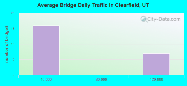
- 949,688Total average daily traffic
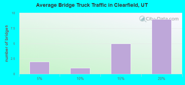
- 146,100Total average daily truck traffic
- National Bridge Inventory (NBI) Registered Bridges for Clearfield
- No street view available for this location
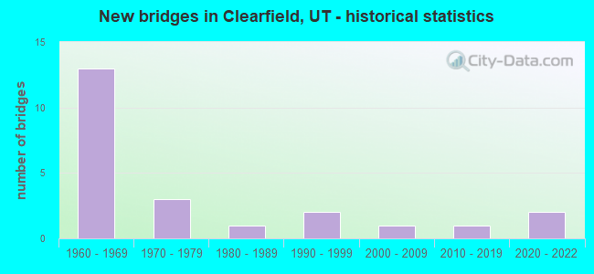
- New bridges - historical statistics
- 131960-1969
- 31970-1979
- 11980-1989
- 21990-1999
- 12000-2009
- 12010-2019
- 22020-2022
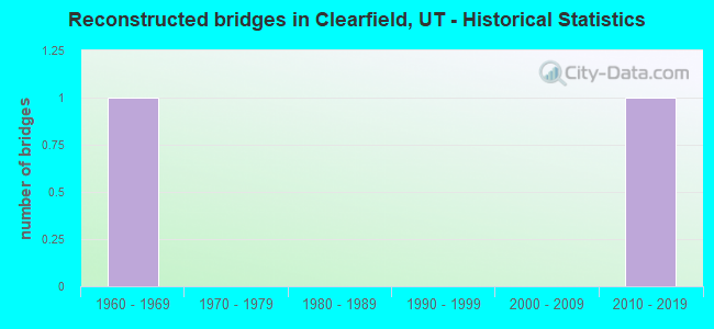
- Reconstructed bridges - Historical Statistics
- 11960-1969
- 01970-1979
- 01980-1989
- 01990-1999
- 02000-2009
- 12010-2019
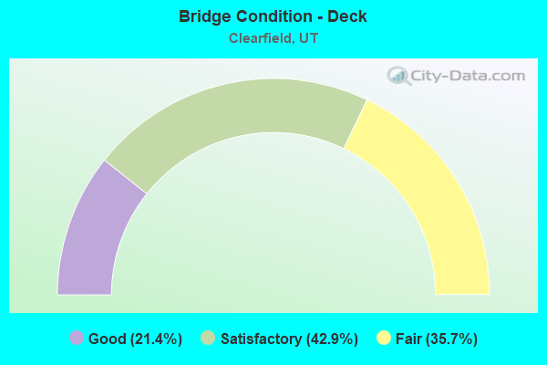
- Bridge Condition - Deck
- 21.4%Good
- 42.9%Satisfactory
- 35.7%Fair
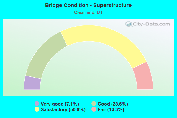
- Bridge Condition - Superstructure
- 7.1%Very good
- 28.6%Good
- 50.0%Satisfactory
- 14.3%Fair
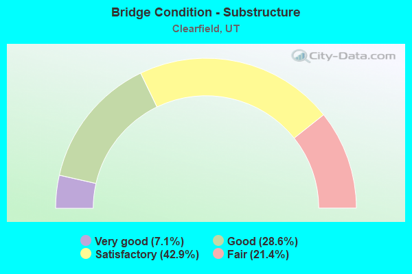
- Bridge Condition - Substructure
- 7.1%Very good
- 28.6%Good
- 42.9%Satisfactory
- 21.4%Fair
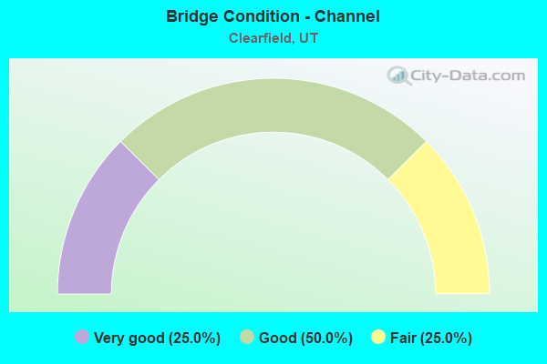
- Bridge Condition - Channel
- 25.0%Very good
- 50.0%Good
- 25.0%Fair
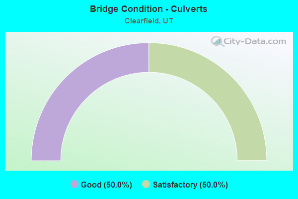
- Bridge Condition - Culverts
- 50.0%Good
- 50.0%Satisfactory
Find on map >> Show street view
Structure Number: 11004E, Location: 600 S.1000 E., CLEARFIELD (Lat: 41.104961, Lng: -112.003706), Route carried "on" structure: City street 1480, Year Built: 1965, Status: Open, Structure Length: 1.13m (3.71ft), Average Daily Traffic: 459 (year 2020), Average Future Daily Traffic: 574 (year 2040), Design Load: HS 20+Mod, Features Intersected: WEBER-DAVIS CANAL, Facility Carried by Structure: 1000 EAST STREET
Minimum Vertical Clearance: 30+ m (98+ ft), Kilometerpoint: 2.141, Lanes on structure: 2, Owner: City or Municipal Highway Agency, Approaching Roadway Width: 8.5m (27.9ft), Skew: 5 degrees, Material/Design: Concrete, Design/Construction: Culvert, Number Of Spans In Main Unit: 1, Length of Maximum Span: 10.4m (34.1ft), Curb or Sidewalk Widths: Left: 1.7m (5.6ft), Right: 0.0m
Condition: Channel: Good, Culverts: Good, Operating Rating: 32.4 metric tons, Method Used To Determine Operating Rating: Load and Resistance Factor Rating (LRFR) rating reported by rating factor(RF) method using HL-93 loadings, Inventory Rating: 21.7 metric tons, Method Used To Determine Inventory Rating: Load and Resistance Factor Rating (LRFR) rating reported by rating factor(RF) method using HL-93 loadings, Structural Evaluation: Equal to present minimum criteria, Waterway Adequacy: Equal to present minimum criteria, Approach Roadway Alignment: Superior to present desirable criteria, Designated Inspection Frequency: Every 23 months, Inspection Date: April 2020
Find on map >> Show street view
Structure Number: 11007F, Location: 350 E.300 N., CLEARFIELD (Lat: 41.118058, Lng: -112.020014), Route carried "on" structure: City street , Year Built: 1965, Status: Open, Structure Length: 0.98m (3.22ft), Average Daily Traffic: 1,008 (year 2020), Truck Traffic: 1%, Average Future Daily Traffic: 1,225 (year 2040), Design Load: HS 20+Mod, Features Intersected: WEBER-DAVIS CANAL, Facility Carried by Structure: 300 NORTH STREET
Minimum Vertical Clearance: 30+ m (98+ ft), Kilometerpoint: 0.034, Lanes on structure: 2, Owner: City or Municipal Highway Agency, Approaching Roadway Width: 9.8m (32.2ft), Skew: 4 degrees, Material/Design: Prestressed concrete, Design/Construction: Tee Beam, Number Of Spans In Main Unit: 1, Length of Maximum Span: 8.7m (28.5ft), Curb or Sidewalk Widths: Left: 1.2m (3.9ft), Right: 1.2m (3.9ft), Curb-To-Curb Width: 9.8m (32.2ft), Out-to-Out Width: 13.3m (43.6ft)
Condition: Deck: Satisfactory, Superstructure: Fair, Substructure: Satisfactory, Channel: Very good, Operating Rating: 32.4 metric tons, Method Used To Determine Operating Rating: Load and Resistance Factor Rating (LRFR) rating reported by rating factor(RF) method using HL-93 loadings, Inventory Rating: 20.7 metric tons, Method Used To Determine Inventory Rating: Load and Resistance Factor Rating (LRFR) rating reported by rating factor(RF) method using HL-93 loadings, Structural Evaluation: Somewhat better than minimum adequacy, Deck Geometry: Somewhat better than minimum adequacy, Waterway Adequacy: Equal to present minimum criteria, Approach Roadway Alignment: Equal to present desirable criteria, Designated Inspection Frequency: Every 24 months, Inspection Date: March 2020, Deck Structure Type: Concrete Precast Panels, Wearing Surface/Protective System: Wearing Surface: Bituminous
Find on map >> Show street view
Structure Number: 11009C, Location: 600 W. 800 N., CLEARFIELD (Lat: 41.125322, Lng: -112.035450), Route carried "on" structure: City street 1492, Year Built: 1985, Status: Open, Structure Length: 3.61m (11.84ft), Average Daily Traffic: 6,639 (year 2020), Average Future Daily Traffic: 8,299 (year 2040), Design Load: HS 20+Mod, Features Intersected: UPRR/Front Runner, Facility Carried by Structure: 800 NORTH STREET
Minimum Vertical Clearance: 30+ m (98+ ft), Kilometerpoint: 6.478, Lanes on structure: 2, Owner: City or Municipal Highway Agency, Approaching Roadway Width: 10.6m (34.8ft), Material/Design: Steel, Design/Construction: Stringer/Multi-beam, Number Of Spans In Main Unit: 1, Length of Maximum Span: 35.5m (116.5ft), Curb or Sidewalk Widths: Left: 0.0m, Right: 1.7m (5.6ft), Curb-To-Curb Width: 10.6m (34.8ft), Out-to-Out Width: 13.2m (43.3ft)
Condition: Deck: Satisfactory, Superstructure: Satisfactory, Substructure: Satisfactory, Operating Rating: 66.4 metric tons, Method Used To Determine Operating Rating: Load and Resistance Factor Rating (LRFR) rating reported by rating factor(RF) method using HL-93 loadings, Inventory Rating: 45.0 metric tons, Method Used To Determine Inventory Rating: Load Factor (LF) rating reported by rating factor (RF) method using MS18 loading, Structural Evaluation: Equal to present minimum criteria, Deck Geometry: Meets minimum limits, Underclear: Superior to present desirable criteria, Approach Roadway Alignment: Equal to present minimum criteria, Designated Inspection Frequency: Every 24 months, Inspection Date: March 2020, Deck Structure Type: Concrete Cast-file-Place, Wearing Surface/Protective System: Wearing Surface: Monolithic Concrete, Deck Protection: Epoxy Coated Reinforcing
Find on map >> Show street view
Structure Number: 11018F, Location: 260 E.BRUCE ST.CLEARFIELD (Lat: 41.120825, Lng: -112.022778), Route carried "on" structure: City street , Year Built: 1974, Status: Open, Structure Length: 1.32m (4.33ft), Average Daily Traffic: 1,008 (year 2020), Truck Traffic: 1%, Average Future Daily Traffic: 1,225 (year 2040), Design Load: HL 93, Features Intersected: WEBER-DAVIS CANAL, Facility Carried by Structure: BRUCE STREET
Minimum Vertical Clearance: 30+ m (98+ ft), Kilometerpoint: 0.055, Lanes on structure: 2, Owner: City or Municipal Highway Agency, Approaching Roadway Width: 8.8m (28.9ft), Material/Design: Prestressed concrete, Design/Construction: Tee Beam, Number Of Spans In Main Unit: 1, Length of Maximum Span: 11.1m (36.4ft), Curb or Sidewalk Widths: Left: 0.0m, Right: 1.1m (3.6ft), Curb-To-Curb Width: 8.8m (28.9ft), Out-to-Out Width: 10.9m (35.8ft)
Condition: Deck: Fair, Superstructure: Satisfactory, Substructure: Satisfactory, Channel: Fair, Operating Rating: 32.4 metric tons, Method Used To Determine Operating Rating: Load and Resistance Factor Rating (LRFR) rating reported by rating factor(RF) method using HL-93 loadings, Inventory Rating: 22.0 metric tons, Method Used To Determine Inventory Rating: Load and Resistance Factor Rating (LRFR) rating reported by rating factor(RF) method using HL-93 loadings, Structural Evaluation: Somewhat better than minimum adequacy, Deck Geometry: Somewhat better than minimum adequacy, Waterway Adequacy: Equal to present minimum criteria, Approach Roadway Alignment: Equal to present minimum criteria, Designated Inspection Frequency: Every 24 months, Inspection Date: March 2020, Deck Structure Type: Concrete Precast Panels, Wearing Surface/Protective System: Wearing Surface: Monolithic Concrete
Find on map >> Show street view
Structure Number: 11023C, Location: 200 W. CENTER, CLEARFIELD (Lat: 41.111600, Lng: -112.026050), Route carried "on" structure: City street , Year Built: 2000, Status: Open, Structure Length: 5.46m (17.91ft), Average Daily Traffic: 2,520 (year 2020), Truck Traffic: 5%, Average Future Daily Traffic: 3,062 (year 2040), Design Load: HS 25 or greater, Features Intersected: UNION PACIFIC RAILROAD, Facility Carried by Structure: 200 SOUTH STREET
Minimum Vertical Clearance: 30+ m (98+ ft), Kilometerpoint: 0.086, Lanes on structure: 2, Owner: City or Municipal Highway Agency, Approaching Roadway Width: 11.4m (37.4ft), Material/Design: Steel, Design/Construction: Stringer/Multi-beam, Number Of Spans In Main Unit: 1, Length of Maximum Span: 53.6m (175.9ft), Curb or Sidewalk Widths: Left: 2.1m (6.9ft), Right: 0.0m, Curb-To-Curb Width: 11.4m (37.4ft), Out-to-Out Width: 14.6m (47.9ft)
Condition: Deck: Satisfactory, Superstructure: Good, Substructure: Good, Operating Rating: 91.0 metric tons, Method Used To Determine Operating Rating: Load and Resistance Factor Rating (LRFR) rating reported by rating factor(RF) method using HL-93 loadings, Inventory Rating: 50.2 metric tons, Method Used To Determine Inventory Rating: Load and Resistance Factor Rating (LRFR) rating reported by rating factor(RF) method using HL-93 loadings, Structural Evaluation: Better than present minimum criteria, Deck Geometry: Somewhat better than minimum adequacy, Underclear: Superior to present desirable criteria, Approach Roadway Alignment: Meets minimum limits, Designated Inspection Frequency: Every 24 months, Inspection Date: April 2020, Deck Structure Type: Concrete Cast-file-Place, Wearing Surface/Protective System: Wearing Surface: Monolithic Concrete, Deck Protection: Epoxy Coated Reinforcing
Find on map >> Show street view
Structure Number: C1005, Location: W of State St. Clearfield (Lat: 41.103661, Lng: -112.021275), Route carried "on" structure: State highway 193, Year Built: 2013, Status: Open, Structure Length: 5.41m (17.75ft), Average Daily Traffic: 24,000 (year 2020), Truck Traffic: 10%, Average Future Daily Traffic: 30,000 (year 2040), Design Load: HL 93, Features Intersected: UPRR & UTA TRACKS
Minimum Vertical Clearance: 30+ m (98+ ft), Kilometerpoint: 5.614, Lanes on structure: 4, Owner: State Highway Agency, Approaching Roadway Width: 26.3m (86.3ft), Skew: 13 degrees, Material/Design: Steel, Design/Construction: Stringer/Multi-beam, Number Of Spans In Main Unit: 1, Length of Maximum Span: 53.1m (174.2ft), Curb or Sidewalk Widths: Left: 0.0m, Right: 2.4m (7.9ft), Curb-To-Curb Width: 26.3m (86.3ft), Out-to-Out Width: 30.1m (98.8ft)
Condition: Deck: Good, Superstructure: Very good, Substructure: Very good, Operating Rating: 58.0 metric tons, Method Used To Determine Operating Rating: Load and Resistance Factor Rating (LRFR) rating reported by rating factor(RF) method using HL-93 loadings, Inventory Rating: 35.0 metric tons, Method Used To Determine Inventory Rating: Load and Resistance Factor Rating (LRFR) rating reported by rating factor(RF) method using HL-93 loadings, Structural Evaluation: Equal to present desirable criteria, Deck Geometry: Superior to present desirable criteria, Underclear: Meets minimum limits, Approach Roadway Alignment: Equal to present desirable criteria, Designated Inspection Frequency: Every 24 months, Inspection Date: June 2021, Deck Structure Type: Concrete Precast Panels, Wearing Surface/Protective System: Wearing Surface: Latex Concrete, Deck Protection: Epoxy Coated Reinforcing
Find on map >> Show street view
Structure Number: E1901, Location: IN CLEARFIELD (Lat: 41.108278, Lng: -112.008253), Route carried "on" structure: Interstate 15, Year Built: 1964, Year Reconstructed: 1972, Status: Open, Structure Length: 1.04m (3.41ft), Average Daily Traffic: 114,229 (year 2020), Truck Traffic: 16%, Average Future Daily Traffic: 142,786 (year 2040), Design Load: HS 20+Mod, Features Intersected: DAVIS-WEBER CANAL
Minimum Vertical Clearance: 30+ m (98+ ft), Kilometerpoint: 538.787, Lanes on structure: 6, Base Highway Network: Yes, Owner: State Highway Agency, Approaching Roadway Width: 38.1m (125.0ft), Skew: 24 degrees, Material/Design: Concrete, Design/Construction: Culvert, Number Of Spans In Main Unit: 1, Length of Maximum Span: 10.3m (33.8ft), Curb-To-Curb Width: 38.1m (125.0ft), Out-to-Out Width: 47.1m (154.5ft)
Condition: Channel: Good, Culverts: Satisfactory, Operating Rating: 40.2 metric tons, Method Used To Determine Operating Rating: Load Factor (LF) rating reported by rating factor (RF) method using MS18 loading, Inventory Rating: 26.2 metric tons, Method Used To Determine Inventory Rating: Load Factor (LF) rating reported by rating factor (RF) method using MS18 loading, Structural Evaluation: Equal to present minimum criteria, Deck Geometry: Superior to present desirable criteria, Waterway Adequacy: Equal to present desirable criteria, Approach Roadway Alignment: Equal to present desirable criteria, Designated Inspection Frequency: Every 24 months, Inspection Date: June 2021
Find on map >> Show street view
Structure Number: F 33, Location: 300 NO.ST.in CLEARFIELD (Lat: 41.118075, Lng: -112.034917), Route carried "on" structure: State highway 1489, Year Built: 1974, Year Reconstructed: 2015, Status: Open, Structure Length: 28.93m (94.91ft), Average Daily Traffic: 9,777 (year 2020), Average Future Daily Traffic: 12,221 (year 2040), Design Load: HL 93, Features Intersected: CITY STREET AND UPRR, Facility Carried by Structure: SR-107
Minimum Vertical Clearance: 30+ m (98+ ft), Kilometerpoint: 4.101, Lanes on structure: 2, Lanes under structure: 2, Owner: City or Municipal Highway Agency, Approaching Roadway Width: 8.7m (28.5ft), Skew: 3 degrees, Material/Design: Prestressed concrete, Design/Construction: Stringer/Multi-beam, Number Of Spans In Main Unit: 9, Length of Maximum Span: 33.5m (109.9ft), Curb or Sidewalk Widths: Left: 0.0m, Right: 1.2m (3.9ft), Curb-To-Curb Width: 8.7m (28.5ft), Out-to-Out Width: 9.8m (32.2ft)
Condition: Deck: Fair, Superstructure: Fair, Substructure: Fair, Operating Rating: 32.4 metric tons, Method Used To Determine Operating Rating: Load Factor (LF) rating reported by rating factor (RF) method using MS18 loading, Inventory Rating: 20.1 metric tons, Method Used To Determine Inventory Rating: Load Factor (LF) rating reported by rating factor (RF) method using MS18 loading, Structural Evaluation: Somewhat better than minimum adequacy, Deck Geometry: Meets minimum limits, Underclear: Equal to present minimum criteria, Approach Roadway Alignment: Equal to present minimum criteria, Designated Inspection Frequency: Every 24 months, Inspection Date: May 2021, Deck Structure Type: Concrete Cast-file-Place, Wearing Surface/Protective System: Wearing Surface: Epoxy Overlay
Find on map >> Show street view
Structure Number: F 581, Location: SO.SIDE FREEPORT CENTER (Lat: 41.089119, Lng: -112.009314), Route carried "on" structure: State highway 108, Year Built: 1995, Status: Open, Structure Length: 5.33m (17.49ft), Average Daily Traffic: 38,628 (year 2020), Truck Traffic: 11%, Average Future Daily Traffic: 48,285 (year 2040), Design Load: HS 20+Mod, Features Intersected: UNION PACIFIC RAILROAD
Minimum Vertical Clearance: 30.18m (99.02ft), Kilometerpoint: 1.809, Lanes on structure: 4, Owner: State Highway Agency, Approaching Roadway Width: 26.2m (86.0ft), Skew: 3 degrees, Material/Design: Prestressed concrete, Design/Construction: Stringer/Multi-beam, Number Of Spans In Main Unit: 3, Length of Maximum Span: 22.3m (73.2ft), Curb or Sidewalk Widths: Left: 2.0m (6.6ft), Right: 2.0m (6.6ft), Curb-To-Curb Width: 26.2m (86.0ft), Out-to-Out Width: 31.3m (102.7ft)
Condition: Deck: Satisfactory, Superstructure: Good, Substructure: Good, Operating Rating: 57.3 metric tons, Method Used To Determine Operating Rating: Load and Resistance Factor Rating (LRFR) rating reported by rating factor(RF) method using HL-93 loadings, Inventory Rating: 37.6 metric tons, Method Used To Determine Inventory Rating: Load Factor (LF) rating reported by rating factor (RF) method using MS18 loading, Structural Evaluation: Better than present minimum criteria, Deck Geometry: Superior to present desirable criteria, Underclear: Equal to present desirable criteria, Approach Roadway Alignment: Equal to present desirable criteria, Designated Inspection Frequency: Every 24 months, Inspection Date: May 2021, Deck Structure Type: Concrete Cast-file-Place, Wearing Surface/Protective System: Wearing Surface: Epoxy Overlay, Deck Protection: Epoxy Coated Reinforcing
Find on map >> Show street view
Structure Number: F 582, Location: SO.SIDE FREEPORT CENTER (Lat: 41.089111, Lng: -112.012475), Route carried "on" structure: State highway 108, Year Built: 1995, Status: Open, Structure Length: 5.88m (19.29ft), Average Daily Traffic: 38,628 (year 2020), Truck Traffic: 11%, Average Future Daily Traffic: 48,285 (year 2040), Design Load: HS 20+Mod, Features Intersected: ABANDONED UPRR
Minimum Vertical Clearance: 30+ m (98+ ft), Kilometerpoint: 2.075, Lanes on structure: 4, Owner: State Highway Agency, Approaching Roadway Width: 26.2m (86.0ft), Skew: 23 degrees, Material/Design: Prestressed concrete continuous, Design/Construction: Stringer/Multi-beam, Number Of Spans In Main Unit: 3, Length of Maximum Span: 24.7m (81.0ft), Curb or Sidewalk Widths: Left: 2.0m (6.6ft), Right: 2.0m (6.6ft), Curb-To-Curb Width: 26.2m (86.0ft), Out-to-Out Width: 31.3m (102.7ft)
Condition: Deck: Satisfactory, Superstructure: Good, Substructure: Satisfactory, Operating Rating: 36.0 metric tons, Method Used To Determine Operating Rating: Load Factor (LF) rating reported by rating factor (RF) method using MS18 loading, Inventory Rating: 23.3 metric tons, Method Used To Determine Inventory Rating: Load Factor (LF) rating reported by rating factor (RF) method using MS18 loading, Structural Evaluation: Somewhat better than minimum adequacy, Deck Geometry: Superior to present desirable criteria, Approach Roadway Alignment: Equal to present desirable criteria, Designated Inspection Frequency: Every 24 months, Inspection Date: May 2021, Deck Structure Type: Concrete Cast-file-Place, Wearing Surface/Protective System: Wearing Surface: Monolithic Concrete, Deck Protection: Epoxy Coated Reinforcing
Find on map >> Show street view
Structure Number: 1D 719, Location: HAFB Intch (650 North) (Lat: 41.122819, Lng: -112.022678), Route carried "on" structure: Interstate 15, Year Built: 1966, Status: Open, Structure Length: 5.29m (17.36ft), Average Daily Traffic: 114,229 (year 2020), Truck Traffic: 16%, Average Future Daily Traffic: 142,786 (year 2040), Design Load: HS 20+Mod, Features Intersected: SR-103 W. GATE HILL AFB
Minimum Vertical Clearance: 30+ m (98+ ft), Kilometerpoint: 540.812, Lanes on structure: 3, Lanes under structure: 5, Base Highway Network: Yes, Owner: State Highway Agency, Approaching Roadway Width: 15.8m (51.8ft), Material/Design: Concrete continuous, Design/Construction: Tee Beam, Number Of Spans In Main Unit: 3, Length of Maximum Span: 23.9m (78.4ft), Curb-To-Curb Width: 15.8m (51.8ft), Out-to-Out Width: 16.8m (55.1ft)
Condition: Deck: Fair, Superstructure: Satisfactory, Substructure: Satisfactory, Operating Rating: 37.3 metric tons, Method Used To Determine Operating Rating: Load and Resistance Factor Rating (LRFR) rating reported by rating factor(RF) method using HL-93 loadings, Inventory Rating: 30.8 metric tons, Method Used To Determine Inventory Rating: Load Factor (LF) rating reported by rating factor (RF) method using MS18 loading, Structural Evaluation: Equal to present minimum criteria, Deck Geometry: Somewhat better than minimum adequacy, Underclear: High priority of corrective action, Approach Roadway Alignment: Equal to present desirable criteria, Designated Inspection Frequency: Every 18 months, Inspection Date: December 2021, Deck Structure Type: Concrete Cast-file-Place, Wearing Surface/Protective System: Wearing Surface: Bituminous, Membrane: Preformed Fabric
Find on map >> Show street view
Structure Number: 1D 747, Location: 800 E. 200 SO. CLEARFIELD (Lat: 41.110178, Lng: -112.009953), Route carried "on" structure: Interstate 15, Year Built: 1966, Status: Open, Structure Length: 3.99m (13.09ft), Average Daily Traffic: 114,229 (year 2020), Truck Traffic: 16%, Average Future Daily Traffic: 142,786 (year 2040), Design Load: HS 20+Mod, Features Intersected: 200 SOUTH STREET
Minimum Vertical Clearance: 30+ m (98+ ft), Kilometerpoint: 539.042, Lanes on structure: 4, Lanes under structure: 2, Base Highway Network: Yes, Owner: State Highway Agency, Approaching Roadway Width: 20.2m (66.3ft), Skew: 3 degrees, Material/Design: Concrete continuous, Design/Construction: Tee Beam, Number Of Spans In Main Unit: 3, Length of Maximum Span: 15.3m (50.2ft), Curb-To-Curb Width: 20.2m (66.3ft), Out-to-Out Width: 21.1m (69.2ft)
Condition: Deck: Satisfactory, Superstructure: Satisfactory, Substructure: Satisfactory, Operating Rating: 39.9 metric tons, Method Used To Determine Operating Rating: Load and Resistance Factor Rating (LRFR) rating reported by rating factor(RF) method using HL-93 loadings, Inventory Rating: 23.7 metric tons, Method Used To Determine Inventory Rating: Load Factor (LF) rating reported by rating factor (RF) method using MS18 loading, Structural Evaluation: Somewhat better than minimum adequacy, Deck Geometry: Equal to present minimum criteria, Underclear: Meets minimum limits, Approach Roadway Alignment: Equal to present desirable criteria, Designated Inspection Frequency: Every 24 months, Inspection Date: June 2021, Deck Structure Type: Concrete Cast-file-Place, Wearing Surface/Protective System: Wearing Surface: Bituminous, Membrane: Preformed Fabric
Find on map >> Show street view
Structure Number: 1F 63, Location: CLEARFIELD INT. (700 SO) (Lat: 41.102542, Lng: -112.002950), Route carried "on" structure: Interstate 15, Year Built: 1966, Status: Open, Structure Length: 6.20m (20.34ft), Average Daily Traffic: 108,894 (year 2020), Truck Traffic: 17%, Average Future Daily Traffic: 136,118 (year 2040), Design Load: HS 20+Mod, Features Intersected: SR-193 700 SO.CLEARFIELD
Minimum Vertical Clearance: 30+ m (98+ ft), Kilometerpoint: 538.010, Lanes on structure: 3, Lanes under structure: 4, Base Highway Network: Yes, Owner: State Highway Agency, Approaching Roadway Width: 15.8m (51.8ft), Skew: 3 degrees, Material/Design: Prestressed concrete, Design/Construction: Stringer/Multi-beam, Number Of Spans In Main Unit: 4, Length of Maximum Span: 17.7m (58.1ft), Curb-To-Curb Width: 15.8m (51.8ft), Out-to-Out Width: 16.8m (55.1ft)
Condition: Deck: Fair, Superstructure: Satisfactory, Substructure: Fair, Operating Rating: 35.3 metric tons, Method Used To Determine Operating Rating: Load and Resistance Factor Rating (LRFR) rating reported by rating factor(RF) method using HL-93 loadings, Inventory Rating: 19.8 metric tons, Method Used To Determine Inventory Rating: Load Factor (LF) rating reported by rating factor (RF) method using MS18 loading, Structural Evaluation: Somewhat better than minimum adequacy, Deck Geometry: Somewhat better than minimum adequacy, Underclear: High priority of corrective action, Approach Roadway Alignment: Equal to present desirable criteria, Designated Inspection Frequency: Every 24 months, Inspection Date: June 2021, Deck Structure Type: Concrete Cast-file-Place, Wearing Surface/Protective System: Wearing Surface: Bituminous, Membrane: Preformed Fabric
Find on map >> Show street view
Structure Number: 3D 719, Location: HAFB Intch (650 North) (Lat: 41.124267, Lng: -112.024433), Route carried "on" structure: Interstate 15, Year Built: 1966, Status: Open, Structure Length: 5.29m (17.36ft), Average Daily Traffic: 114,229 (year 2020), Truck Traffic: 16%, Average Future Daily Traffic: 142,786 (year 2040), Design Load: HS 20+Mod, Features Intersected: SR-103 W. GATE HILL AFB
Minimum Vertical Clearance: 30+ m (98+ ft), Kilometerpoint: 540.818, Lanes on structure: 3, Lanes under structure: 5, Base Highway Network: Yes, Owner: State Highway Agency, Approaching Roadway Width: 15.8m (51.8ft), Material/Design: Concrete continuous, Design/Construction: Tee Beam, Number Of Spans In Main Unit: 3, Length of Maximum Span: 23.9m (78.4ft), Curb-To-Curb Width: 15.8m (51.8ft), Out-to-Out Width: 16.8m (55.1ft)
Condition: Deck: Fair, Superstructure: Satisfactory, Substructure: Good, Operating Rating: 37.3 metric tons, Method Used To Determine Operating Rating: Load and Resistance Factor Rating (LRFR) rating reported by rating factor(RF) method using HL-93 loadings, Inventory Rating: 30.8 metric tons, Method Used To Determine Inventory Rating: Load Factor (LF) rating reported by rating factor (RF) method using MS18 loading, Structural Evaluation: Equal to present minimum criteria, Deck Geometry: Somewhat better than minimum adequacy, Underclear: High priority of corrective action, Approach Roadway Alignment: Equal to present desirable criteria, Designated Inspection Frequency: Every 18 months, Inspection Date: December 2021, Deck Structure Type: Concrete Cast-file-Place, Wearing Surface/Protective System: Wearing Surface: Bituminous, Membrane: Preformed Fabric
Find on map >> Show street view
Structure Number: 3F 63, Location: CLEARFIELD INT (700 SO) (Lat: 41.104436, Lng: -112.004997), Route carried "on" structure: Interstate 15, Year Built: 1966, Status: Open, Structure Length: 6.20m (20.34ft), Average Daily Traffic: 108,894 (year 2020), Truck Traffic: 17%, Average Future Daily Traffic: 136,118 (year 2040), Design Load: HS 20+Mod, Features Intersected: SR-193,700 SO.CLEARFIELD
Minimum Vertical Clearance: 30+ m (98+ ft), Kilometerpoint: 538.071, Lanes on structure: 3, Lanes under structure: 5, Base Highway Network: Yes, Owner: State Highway Agency, Approaching Roadway Width: 15.8m (51.8ft), Skew: 3 degrees, Material/Design: Prestressed concrete, Design/Construction: Stringer/Multi-beam, Number Of Spans In Main Unit: 4, Length of Maximum Span: 17.7m (58.1ft), Curb-To-Curb Width: 15.8m (51.8ft), Out-to-Out Width: 16.8m (55.1ft)
Condition: Deck: Good, Superstructure: Satisfactory, Substructure: Fair, Operating Rating: 36.9 metric tons, Method Used To Determine Operating Rating: Load and Resistance Factor Rating (LRFR) rating reported by rating factor(RF) method using HL-93 loadings, Inventory Rating: 32.4 metric tons, Method Used To Determine Inventory Rating: Load Factor (LF) rating reported by rating factor (RF) method using MS18 loading, Structural Evaluation: Somewhat better than minimum adequacy, Deck Geometry: Somewhat better than minimum adequacy, Underclear: High priority of corrective action, Approach Roadway Alignment: Equal to present desirable criteria, Designated Inspection Frequency: Every 24 months, Inspection Date: June 2021, Deck Structure Type: Concrete Cast-file-Place, Wearing Surface/Protective System: Wearing Surface: Bituminous, Membrane: Preformed Fabric
Find on map >> Show street view
Structure Number: 3F 901, Location: I-15 over 200 S (Lat: 41.110931, Lng: -112.011136), Route carried "on" structure: Interstate 15, Year Built: 2020, Status: Open, Structure Length: 2.53m (8.30ft), Average Daily Traffic: 114,229 (year 2020), Truck Traffic: 16%, Average Future Daily Traffic: 142,786 (year 2040), Design Load: HL 93, Features Intersected: 200 S
Minimum Vertical Clearance: 30+ m (98+ ft), Kilometerpoint: 538.654, Lanes on structure: 4, Lanes under structure: 2, Base Highway Network: Yes, Owner: State Highway Agency, Approaching Roadway Width: 21.5m (70.5ft), Skew: 3 degrees, Material/Design: Prestressed concrete, Design/Construction: Stringer/Multi-beam, Number Of Spans In Main Unit: 1, Length of Maximum Span: 24.0m (78.7ft), Curb-To-Curb Width: 21.5m (70.5ft), Out-to-Out Width: 22.3m (73.2ft)
Condition: Deck: Good, Superstructure: Good, Substructure: Good, Operating Rating: 45.4 metric tons, Method Used To Determine Operating Rating: Load and Resistance Factor Rating (LRFR) rating reported by rating factor(RF) method using HL-93 loadings, Inventory Rating: 35.6 metric tons, Method Used To Determine Inventory Rating: Load and Resistance Factor Rating (LRFR) rating reported by rating factor(RF) method using HL-93 loadings, Structural Evaluation: Better than present minimum criteria, Deck Geometry: Better than present minimum criteria, Underclear: Better than present minimum criteria, Approach Roadway Alignment: Equal to present desirable criteria, Designated Inspection Frequency: Every 24 months, Inspection Date: June 2021, Deck Structure Type: Concrete Cast-file-Place, Wearing Surface/Protective System: Wearing Surface: Epoxy Overlay, Deck Protection: Epoxy Coated Reinforcing
Find on map >> Show street view
Structure Number: F 33, Location: 300 NO.ST.in CLEARFIELD (Lat: 41.118075, Lng: -112.034917), Route carried "under" structure: City street , Year Built: 1974, Structure Length: 0. m, Average Daily Traffic: 50 (year 2020), Features Intersected: CITY STREET AND UPRR, Facility Carried by Structure: SR-107
Minimum Vertical Clearance: 4.25m (13.94ft), Kilometerpoint: 0.000, Lanes on structure: 2, Lanes under structure: 2, Material/Design: Prestressed concrete, Design/Construction: Stringer/Multi-beam, Length of Maximum Span: 33.5m (109.9ft)
Find on map >> Show street view
Structure Number: 1D 719, Location: HAFB Intch (650 North) (Lat: 41.122819, Lng: -112.022678), Route carried "under" structure: State highway 103, Year Built: 1966, Structure Length: 0. m, Average Daily Traffic: 16,363 (year 2020), Truck Traffic: 19%, Features Intersected: SR-103 W. GATE HILL AFB, Facility Carried by Structure: I-15 (SR-15) NBL
Minimum Vertical Clearance: 5.20m (17.06ft), Kilometerpoint: 0.225, Lanes on structure: 3, Lanes under structure: 5, Material/Design: Concrete continuous, Design/Construction: Tee Beam, Length of Maximum Span: 23.9m (78.4ft)
Find on map >> Show street view
Structure Number: 1D 747, Location: 800 E. 200 SO. CLEARFIELD (Lat: 41.110178, Lng: -112.009953), Route carried "under" structure: City street 1480, Year Built: 1966, Structure Length: 0. m, Average Daily Traffic: 459 (year 2020), Features Intersected: 200 SOUTH STREET, Facility Carried by Structure: I-15 (SR-15) NBL
Minimum Vertical Clearance: 4.82m (15.81ft), Kilometerpoint: 0.000, Lanes on structure: 4, Lanes under structure: 2, Material/Design: Concrete continuous, Design/Construction: Tee Beam, Length of Maximum Span: 15.3m (50.2ft)
Find on map >> Show street view
Structure Number: 1F 63, Location: CLEARFIELD INT. (700 SO) (Lat: 41.102542, Lng: -112.002950), Route carried "under" structure: State highway 193, Year Built: 1966, Structure Length: 0. m, Average Daily Traffic: 2,197 (year 2020), Truck Traffic: 10%, Features Intersected: SR-193 700 SO.CLEARFIELD, Facility Carried by Structure: I-15 (SR-15) NBL
Minimum Vertical Clearance: 4.90m (16.08ft), Kilometerpoint: 0.901, Lanes on structure: 3, Lanes under structure: 4, Material/Design: Prestressed concrete, Design/Construction: Stringer/Multi-beam, Length of Maximum Span: 17.7m (58.1ft)
Find on map >> Show street view
Structure Number: 3D 719, Location: HAFB Intch (650 North) (Lat: 41.124267, Lng: -112.024433), Route carried "under" structure: State highway 103, Year Built: 1966, Structure Length: 0. m, Average Daily Traffic: 16,363 (year 2020), Truck Traffic: 19%, Features Intersected: SR-103 W. GATE HILL AFB, Facility Carried by Structure: I-15 (SR-15) SBL
Minimum Vertical Clearance: 5.05m (16.57ft), Kilometerpoint: 0.177, Lanes on structure: 3, Lanes under structure: 5, Material/Design: Concrete continuous, Design/Construction: Tee Beam, Length of Maximum Span: 23.9m (78.4ft)
Find on map >> Show street view
Structure Number: 3F 63, Location: CLEARFIELD INT (700 SO) (Lat: 41.104436, Lng: -112.004997), Route carried "under" structure: State highway 193, Year Built: 1966, Structure Length: 0. m, Average Daily Traffic: 2,197 (year 2020), Truck Traffic: 10%, Features Intersected: SR-193,700 SO.CLEARFIELD, Facility Carried by Structure: I-15 (SR-15) SBL
Minimum Vertical Clearance: 5.13m (16.83ft), Kilometerpoint: 0.933, Lanes on structure: 3, Lanes under structure: 5, Material/Design: Prestressed concrete, Design/Construction: Stringer/Multi-beam, Length of Maximum Span: 17.7m (58.1ft)
Find on map >> Show street view
Structure Number: 3F 901, Location: I-15 over 200 S (Lat: 41.110931, Lng: -112.011136), Route carried "under" structure: City street 1480, Year Built: 2020, Structure Length: 0. m, Average Daily Traffic: 459 (year 2020), Features Intersected: 200 S, Facility Carried by Structure: I-15 SB
Minimum Vertical Clearance: 4.74m (15.55ft), Kilometerpoint: 0.000, Lanes on structure: 4, Lanes under structure: 2, Material/Design: Prestressed concrete, Design/Construction: Stringer/Multi-beam, Length of Maximum Span: 24.0m (78.7ft)