Bridge Statistics for Clifton Forge, Virginia (VA)
Condition, Traffic, Stress, Structural Evaluation, Project Costs
- National Bridge Inventory (NBI) Statistics
- 35Number of bridges
- 459ft / 140mTotal length
- $33,633,000Total costs
- 93,122Total average daily traffic
- 15,082Total average daily truck traffic
- National Bridge Inventory (NBI) Registered Bridges for Clifton Forge
- No street view available for this location
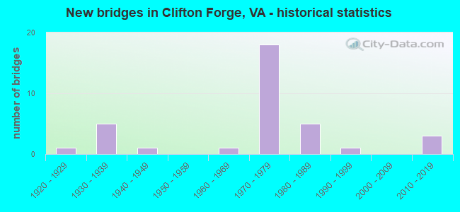
- New bridges - historical statistics
- 11920-1929
- 51930-1939
- 11940-1949
- 11960-1969
- 181970-1979
- 51980-1989
- 11990-1999
- 32010-2019


- Bridge Condition - Deck
- 5.3%Very good
- 47.4%Good
- 31.6%Satisfactory
- 15.8%Fair

- Bridge Condition - Superstructure
- 9.5%Very good
- 33.3%Good
- 38.1%Satisfactory
- 14.3%Fair
- 4.8%Poor

- Bridge Condition - Substructure
- 47.6%Good
- 28.6%Satisfactory
- 23.8%Fair

- Bridge Condition - Channel
- 31.8%Very good
- 31.8%Good
- 18.2%Satisfactory
- 9.1%Fair
- 9.1%Poor

- Bridge Condition - Culverts
- 16.7%Very good
- 16.7%Good
- 50.0%Satisfactory
- 16.7%Poor
Find on map >> Show street view
Structure Number: 935, Location: 0.01 TO 671 & 0.39 TO 627 (Lat: 37.820964, Lng: -79.798383), Route carried "on" structure: US 60, Year Built: 1942, Status: Open, Structure Length: 0.88m (2.89ft), Average Daily Traffic: 5,665 (year 2020), Truck Traffic: 5%, Average Future Daily Traffic: 6,461 (year 2040), Design Load: HS 20, Features Intersected: DRY RUN, Facility Carried by Structure: GRAFTON STREET
Minimum Vertical Clearance: 30+ m (98+ ft), Kilometerpoint: 22.140, Lanes on structure: 2, Owner: State Highway Agency, Approaching Roadway Width: 11.0m (36.1ft), Skew: 4 degrees, Material/Design: Concrete, Design/Construction: Culvert, Number Of Spans In Main Unit: 2, Length of Maximum Span: 3.0m (9.8ft)
Condition: Channel: Satisfactory, Culverts: Satisfactory, Operating Rating: 44.5 metric tons, Method Used To Determine Operating Rating: Load Factor (LF), Inventory Rating: 32.7 metric tons, Method Used To Determine Inventory Rating: Load Factor (LF), Structural Evaluation: Equal to present minimum criteria, Waterway Adequacy: Better than present minimum criteria, Approach Roadway Alignment: Equal to present desirable criteria, Length Of Structure Improvement: 0.88m (2.89ft), Designated Inspection Frequency: Every 24 months, Inspection Date: September 2020, Bridge Improvement Cost: $10,000, Roadway Improvement Cost: $10,000, Total Project Cost: $30,000 ( Estimate for 2014)
Find on map >> Show street view
Structure Number: 982, Location: 1.25 ECL CF - 1.75 RT 42 (Lat: 37.827014, Lng: -79.793294), Route carried "on" structure: Interstate 64, Year Built: 1971, Status: Open, Structure Length: 5.46m (17.91ft), Average Daily Traffic: 4,451 (year 2020), Truck Traffic: 24%, Average Future Daily Traffic: 6,231 (year 2040), Design Load: HS 20+Mod, Features Intersected: ROUTE 60 & 629
Minimum Vertical Clearance: 30+ m (98+ ft), Kilometerpoint: 44.650, Lanes on structure: 2, Lanes under structure: 4, Base Highway Network: Yes, Owner: State Highway Agency, Approaching Roadway Width: 11.3m (37.1ft), Skew: 1 degrees, Material/Design: Prestressed concrete, Design/Construction: Stringer/Multi-beam, Number Of Spans In Main Unit: 4, Length of Maximum Span: 15.2m (49.9ft), Curb or Sidewalk Widths: Left: 0.2m (0.7ft), Right: 0.2m (0.7ft), Curb-To-Curb Width: 12.0m (39.4ft), Out-to-Out Width: 13.0m (42.7ft)
Condition: Deck: Good, Superstructure: Good, Substructure: Good, Operating Rating: 84.4 metric tons, Method Used To Determine Operating Rating: Load and Resistance Factor (LRFR), Inventory Rating: 52.6 metric tons, Method Used To Determine Inventory Rating: Load and Resistance Factor (LRFR), Structural Evaluation: Better than present minimum criteria, Deck Geometry: Equal to present minimum criteria, Underclear: Equal to present desirable criteria, Approach Roadway Alignment: Equal to present desirable criteria, Designated Inspection Frequency: Every 24 months, Inspection Date: September 2020, Bridge Improvement Cost: $63,000, Roadway Improvement Cost: $6,000, Total Project Cost: $72,000 ( Estimate for 2014), Deck Structure Type: Concrete Cast-file-Place, Wearing Surface/Protective System: Wearing Surface: Latex Concrete
Find on map >> Show street view
Structure Number: 984, Location: 1.25 ECL CF - 1.75 RT 42 (Lat: 37.827200, Lng: -79.793231), Route carried "on" structure: Interstate 64, Year Built: 1971, Status: Open, Structure Length: 5.46m (17.91ft), Average Daily Traffic: 4,406 (year 2020), Truck Traffic: 24%, Average Future Daily Traffic: 6,168 (year 2040), Design Load: HS 20+Mod, Features Intersected: ROUTE 60 & ROUTE 629
Minimum Vertical Clearance: 30+ m (98+ ft), Kilometerpoint: 44.698, Lanes on structure: 2, Lanes under structure: 4, Base Highway Network: Yes, Owner: State Highway Agency, Approaching Roadway Width: 11.3m (37.1ft), Skew: 1 degrees, Material/Design: Prestressed concrete, Design/Construction: Stringer/Multi-beam, Number Of Spans In Main Unit: 4, Length of Maximum Span: 15.2m (49.9ft), Curb or Sidewalk Widths: Left: 0.2m (0.7ft), Right: 0.2m (0.7ft), Curb-To-Curb Width: 12.0m (39.4ft), Out-to-Out Width: 13.0m (42.7ft)
Condition: Deck: Good, Superstructure: Good, Substructure: Good, Operating Rating: 87.1 metric tons, Method Used To Determine Operating Rating: Load and Resistance Factor (LRFR), Inventory Rating: 55.3 metric tons, Method Used To Determine Inventory Rating: Load and Resistance Factor (LRFR), Structural Evaluation: Better than present minimum criteria, Deck Geometry: Equal to present minimum criteria, Underclear: Equal to present desirable criteria, Approach Roadway Alignment: Equal to present desirable criteria, Designated Inspection Frequency: Every 24 months, Inspection Date: September 2020, Bridge Improvement Cost: $63,000, Roadway Improvement Cost: $10,000, Total Project Cost: $78,000 ( Estimate for 2014), Deck Structure Type: Concrete Cast-file-Place, Wearing Surface/Protective System: Wearing Surface: Epoxy Overlay
Find on map >> Show street view
Structure Number: 99, Location: 0.22 RT 60 - 1.53 RT 42 (Lat: 37.826664, Lng: -79.789506), Route carried "on" structure: Interstate 64, Year Built: 1971, Status: Open, Structure Length: 3.95m (12.96ft), Average Daily Traffic: 4,451 (year 2020), Truck Traffic: 24%, Average Future Daily Traffic: 6,231 (year 2040), Design Load: HS 20+Mod, Features Intersected: WILSON CREEK
Minimum Vertical Clearance: 30+ m (98+ ft), Kilometerpoint: 45.020, Lanes on structure: 3, Base Highway Network: Yes, Owner: State Highway Agency, Approaching Roadway Width: 14.9m (48.9ft), Material/Design: Prestressed concrete, Design/Construction: Stringer/Multi-beam, Number Of Spans In Main Unit: 3, Length of Maximum Span: 13.1m (43.0ft), Curb-To-Curb Width: 15.8m (51.8ft), Out-to-Out Width: 17.1m (56.1ft)
Condition: Deck: Good, Superstructure: Good, Substructure: Good, Channel: Good, Operating Rating: 89.8 metric tons, Method Used To Determine Operating Rating: Load and Resistance Factor (LRFR), Inventory Rating: 55.3 metric tons, Method Used To Determine Inventory Rating: Load and Resistance Factor (LRFR), Structural Evaluation: Better than present minimum criteria, Deck Geometry: Somewhat better than minimum adequacy, Waterway Adequacy: Better than present minimum criteria, Approach Roadway Alignment: Equal to present desirable criteria, Length Of Structure Improvement: 3.96m (12.99ft), Designated Inspection Frequency: Every 24 months, Inspection Date: September 2020, Bridge Improvement Cost: $75,000, Roadway Improvement Cost: $10,000, Total Project Cost: $95,000 ( Estimate for 2014), Deck Structure Type: Concrete Cast-file-Place, Wearing Surface/Protective System: Wearing Surface: Epoxy Overlay
Find on map >> Show street view
Structure Number: 991, Location: 0.22 RT 60 - 1.53 RT 42 (Lat: 37.826847, Lng: -79.789475), Route carried "on" structure: Interstate 64, Year Built: 1971, Status: Open, Structure Length: 3.96m (12.99ft), Average Daily Traffic: 4,406 (year 2020), Truck Traffic: 24%, Average Future Daily Traffic: 6,168 (year 2040), Design Load: HS 20+Mod, Features Intersected: WILSON CREEK
Minimum Vertical Clearance: 30+ m (98+ ft), Kilometerpoint: 45.068, Lanes on structure: 3, Base Highway Network: Yes, Owner: State Highway Agency, Approaching Roadway Width: 14.9m (48.9ft), Material/Design: Prestressed concrete, Design/Construction: Stringer/Multi-beam, Number Of Spans In Main Unit: 3, Length of Maximum Span: 13.1m (43.0ft), Curb-To-Curb Width: 15.8m (51.8ft), Out-to-Out Width: 17.1m (56.1ft)
Condition: Deck: Good, Superstructure: Good, Substructure: Good, Channel: Good, Operating Rating: 89.8 metric tons, Method Used To Determine Operating Rating: Load and Resistance Factor (LRFR), Inventory Rating: 55.3 metric tons, Method Used To Determine Inventory Rating: Load and Resistance Factor (LRFR), Structural Evaluation: Better than present minimum criteria, Deck Geometry: Somewhat better than minimum adequacy, Waterway Adequacy: Better than present minimum criteria, Approach Roadway Alignment: Equal to present minimum criteria, Length Of Structure Improvement: 3.96m (12.99ft), Designated Inspection Frequency: Every 24 months, Inspection Date: September 2020, Bridge Improvement Cost: $75,000, Roadway Improvement Cost: $10,000, Total Project Cost: $96,000 ( Estimate for 2014), Deck Structure Type: Concrete Cast-file-Place, Wearing Surface/Protective System: Wearing Surface: Epoxy Overlay
Find on map >> Show street view
Structure Number: 992, Location: 0.34 TO 60 & 0.64 TO WCL (Lat: 37.812683, Lng: -79.846300), Route carried "on" structure: Interstate 64, Year Built: 1971, Status: Open, Structure Length: 19.80m (64.96ft), Average Daily Traffic: 5,750 (year 2020), Truck Traffic: 24%, Average Future Daily Traffic: 7,886 (year 2040), Design Load: HS 20+Mod, Features Intersected: JACKSON RIVER
Minimum Vertical Clearance: 30+ m (98+ ft), Kilometerpoint: 39.050, Lanes on structure: 3, Base Highway Network: Yes, Owner: State Highway Agency, Approaching Roadway Width: 11.3m (37.1ft), Material/Design: Steel continuous, Design/Construction: Stringer/Multi-beam, Number Of Spans In Main Unit: 3, Length of Maximum Span: 77.7m (254.9ft), Curb-To-Curb Width: 14.6m (47.9ft), Out-to-Out Width: 15.8m (51.8ft)
Condition: Deck: Satisfactory, Superstructure: Satisfactory, Substructure: Fair, Channel: Very good, Operating Rating: 78.0 metric tons, Method Used To Determine Operating Rating: Load and Resistance Factor (LRFR), Inventory Rating: 59.9 metric tons, Method Used To Determine Inventory Rating: Load and Resistance Factor (LRFR), Structural Evaluation: Somewhat better than minimum adequacy, Deck Geometry: Meets minimum limits, Waterway Adequacy: Equal to present desirable criteria, Approach Roadway Alignment: Equal to present desirable criteria, Length Of Structure Improvement: 19.81m (64.99ft), Designated Inspection Frequency: Every 24 months, Inspection Date: December 2020, Bridge Improvement Cost: $160,000, Roadway Improvement Cost: $20,000, Total Project Cost: $180,000, Deck Structure Type: Concrete Cast-file-Place, Wearing Surface/Protective System: Wearing Surface: Epoxy Overlay
Find on map >> Show street view
Structure Number: 993, Location: 0.34 TO 60 & 0.64 TO WCL (Lat: 37.812806, Lng: -79.846472), Route carried "on" structure: Interstate 64, Year Built: 1971, Status: Open, Structure Length: 19.80m (64.96ft), Average Daily Traffic: 4,650 (year 2020), Truck Traffic: 24%, Average Future Daily Traffic: 6,510 (year 2040), Design Load: HS 20+Mod, Features Intersected: JACKSON RIVER
Minimum Vertical Clearance: 30+ m (98+ ft), Kilometerpoint: 39.083, Lanes on structure: 2, Base Highway Network: Yes, Owner: State Highway Agency, Approaching Roadway Width: 11.3m (37.1ft), Material/Design: Steel continuous, Design/Construction: Stringer/Multi-beam, Number Of Spans In Main Unit: 3, Length of Maximum Span: 77.7m (254.9ft), Curb-To-Curb Width: 12.2m (40.0ft), Out-to-Out Width: 13.4m (44.0ft)
Condition: Deck: Satisfactory, Superstructure: Satisfactory, Substructure: Satisfactory, Channel: Very good, Operating Rating: 77.1 metric tons, Method Used To Determine Operating Rating: Load and Resistance Factor (LRFR), Inventory Rating: 59.0 metric tons, Method Used To Determine Inventory Rating: Load and Resistance Factor (LRFR), Structural Evaluation: Equal to present minimum criteria, Deck Geometry: Better than present minimum criteria, Waterway Adequacy: Equal to present desirable criteria, Approach Roadway Alignment: Equal to present desirable criteria, Length Of Structure Improvement: 19.81m (64.99ft), Designated Inspection Frequency: Every 24 months, Inspection Date: December 2020, Bridge Improvement Cost: $175,000, Roadway Improvement Cost: $25,000, Total Project Cost: $200,000, Deck Structure Type: Concrete Cast-file-Place, Wearing Surface/Protective System: Wearing Surface: Epoxy Overlay
Find on map >> Show street view
Structure Number: 1045, Location: 0.90 TO 1706 & 0.35 TO 60 (Lat: 37.812994, Lng: -79.799142), Route carried "on" structure: US 220, Year Built: 1987, Status: Open, Structure Length: 20.74m (68.04ft), Average Daily Traffic: 5,545 (year 2020), Truck Traffic: 7%, Average Future Daily Traffic: 6,467 (year 2040), Design Load: HS 20+Mod, Features Intersected: CSX & JACKSON RIVER, Facility Carried by Structure: MARKET AVENUE
Minimum Vertical Clearance: 30+ m (98+ ft), Kilometerpoint: 176.655, Lanes on structure: 2, Base Highway Network: Yes, Owner: State Highway Agency, Approaching Roadway Width: 13.0m (42.7ft), Skew: 9 degrees, Material/Design: Steel continuous, Design/Construction: Stringer/Multi-beam, Number Of Spans In Main Unit: 3, Number Of Approach Spans: 2, Length of Maximum Span: 51.8m (169.9ft), Curb-To-Curb Width: 13.0m (42.7ft), Out-to-Out Width: 14.0m (45.9ft)
Condition: Deck: Satisfactory, Superstructure: Satisfactory, Substructure: Satisfactory, Channel: Satisfactory, Operating Rating: 39.9 metric tons, Method Used To Determine Operating Rating: Load and Resistance Factor (LRFR), Inventory Rating: 30.8 metric tons, Method Used To Determine Inventory Rating: Load and Resistance Factor (LRFR), Structural Evaluation: Equal to present minimum criteria, Deck Geometry: Somewhat better than minimum adequacy, Underclear: Better than present minimum criteria, Waterway Adequacy: Equal to present desirable criteria, Approach Roadway Alignment: Better than present minimum criteria, Designated Inspection Frequency: Every 24 months, Inspection Date: January 2022, Deck Structure Type: Concrete Cast-file-Place, Wearing Surface/Protective System: Wearing Surface: Epoxy Overlay, Deck Protection: Epoxy Coated Reinforcing
Find on map >> Show street view
Structure Number: 1046, Location: 1.00 TO 1706 & 0.25 TO 60 (Lat: 37.815478, Lng: -79.799394), Route carried "on" structure: US 220, Year Built: 1987, Status: Open, Structure Length: 7.77m (25.49ft), Average Daily Traffic: 5,545 (year 2020), Truck Traffic: 7%, Average Future Daily Traffic: 6,467 (year 2040), Design Load: HS 20+Mod, Features Intersected: BUCKINGHAM BRANCH RWY, Facility Carried by Structure: MARKET AVENUE
Minimum Vertical Clearance: 30+ m (98+ ft), Kilometerpoint: 176.945, Lanes on structure: 2, Base Highway Network: Yes, Owner: State Highway Agency, Approaching Roadway Width: 7.3m (24.0ft), Skew: 4 degrees, Material/Design: Steel continuous, Design/Construction: Stringer/Multi-beam, Number Of Spans In Main Unit: 3, Length of Maximum Span: 32.3m (106.0ft), Curb-To-Curb Width: 13.0m (42.7ft), Out-to-Out Width: 14.0m (45.9ft)
Condition: Deck: Good, Superstructure: Satisfactory, Substructure: Satisfactory, Operating Rating: 49.0 metric tons, Method Used To Determine Operating Rating: Load and Resistance Factor (LRFR), Inventory Rating: 37.2 metric tons, Method Used To Determine Inventory Rating: Load and Resistance Factor (LRFR), Structural Evaluation: Equal to present minimum criteria, Deck Geometry: Somewhat better than minimum adequacy, Underclear: Better than present minimum criteria, Approach Roadway Alignment: Equal to present desirable criteria, Designated Inspection Frequency: Every 24 months, Inspection Date: January 2022, Deck Structure Type: Concrete Cast-file-Place, Wearing Surface/Protective System: Wearing Surface: Epoxy Overlay, Deck Protection: Epoxy Coated Reinforcing
Find on map >> Show street view
Structure Number: 1092, Location: 3.60 TO 703 & 2.00 TO 699 (Lat: 37.857928, Lng: -79.865208), Route carried "on" structure: County highway 606, Year Built: 1932, Status: Open, Structure Length: 1.35m (4.43ft), Average Daily Traffic: 196 (year 2020), Average Future Daily Traffic: 274 (year 2040), Design Load: HS 20, Features Intersected: PINEY BRANCH, Facility Carried by Structure: SULPHUR SPRING RD
Minimum Vertical Clearance: 30+ m (98+ ft), Kilometerpoint: 5.471, Lanes on structure: 2, Owner: State Highway Agency, Approaching Roadway Width: 5.5m (18.0ft), Skew: 4 degrees, Material/Design: Concrete, Design/Construction: Culvert, Number Of Spans In Main Unit: 3, Length of Maximum Span: 3.0m (9.8ft)
Condition: Channel: Fair, Culverts: Satisfactory, Operating Rating: 52.6 metric tons, Method Used To Determine Operating Rating: Field evaluation and documented engineering judgment, Inventory Rating: 30.8 metric tons, Method Used To Determine Inventory Rating: Field evaluation and documented engineering judgment, Structural Evaluation: Equal to present minimum criteria, Waterway Adequacy: Better than present minimum criteria, Approach Roadway Alignment: Better than present minimum criteria, Length Of Structure Improvement: 1.34m (4.40ft), Designated Inspection Frequency: Every 24 months, Inspection Date: August 2020, Bridge Improvement Cost: $30,000, Total Project Cost: $30,000
Find on map >> Show street view
Structure Number: 1148, Location: 0.85 RT 670 - 0.05 RT 671 (Lat: 37.819119, Lng: -79.797544), Route carried "on" structure: County highway 632, Year Built: 1932, Status: Open, Structure Length: 1.34m (4.40ft), Average Daily Traffic: 50 (year 2020), Average Future Daily Traffic: 55 (year 2040), Features Intersected: WILSON CREEK, Facility Carried by Structure: GOLF COURSE RD
Minimum Vertical Clearance: 30+ m (98+ ft), Kilometerpoint: 2.803, Lanes on structure: 1, Owner: State Highway Agency, Approaching Roadway Width: 2.7m (8.9ft), Material/Design: Concrete, Design/Construction: Tee Beam, Number Of Spans In Main Unit: 1, Length of Maximum Span: 13.4m (44.0ft), Curb or Sidewalk Widths: Left: 0.5m (1.6ft), Right: 0.5m (1.6ft), Curb-To-Curb Width: 4.5m (14.8ft), Out-to-Out Width: 5.5m (18.0ft)
Condition: Deck: Fair, Superstructure: Fair, Substructure: Fair, Channel: Fair, Operating Rating: 45.7 metric tons, Method Used To Determine Operating Rating: Field evaluation and documented engineering judgment, Inventory Rating: 32.7 metric tons, Method Used To Determine Inventory Rating: Field evaluation and documented engineering judgment, Structural Evaluation: Somewhat better than minimum adequacy, Deck Geometry: Equal to present minimum criteria, Waterway Adequacy: Equal to present minimum criteria, Approach Roadway Alignment: Somewhat better than minimum adequacy, Length Of Structure Improvement: 1.34m (4.40ft), Designated Inspection Frequency: Every 24 months, Inspection Date: September 2021, Bridge Improvement Cost: $150,000, Roadway Improvement Cost: $35,000, Total Project Cost: $215,000 ( Estimate for 2015), Deck Structure Type: Concrete Cast-file-Place, Wearing Surface/Protective System: Wearing Surface: Bituminous
Find on map >> Show street view
Structure Number: 1176, Location: 0.40 TO 632 & 0.10 TO 60 (Lat: 37.824647, Lng: -79.792644), Route carried "on" structure: County highway 670, Year Built: 1984, Status: Open, Structure Length: 1.71m (5.61ft), Average Daily Traffic: 1,113 (year 2020), Truck Traffic: 1%, Average Future Daily Traffic: 1,232 (year 2040), Design Load: HS 20+Mod, Features Intersected: WILSON CREEK, Facility Carried by Structure: LONGDALE FURNACERD
Minimum Vertical Clearance: 30+ m (98+ ft), Kilometerpoint: 0.161, Lanes on structure: 2, Owner: State Highway Agency, Approaching Roadway Width: 6.1m (20.0ft), Material/Design: Prestressed concrete, Design/Construction: Box Beam or Girders - Multiple, Number Of Spans In Main Unit: 1, Length of Maximum Span: 17.1m (56.1ft), Curb-To-Curb Width: 8.7m (28.5ft), Out-to-Out Width: 9.8m (32.2ft)
Condition: Deck: Good, Superstructure: Good, Substructure: Good, Channel: Very good, Operating Rating: 64.4 metric tons, Method Used To Determine Operating Rating: Load and Resistance Factor (LRFR), Inventory Rating: 49.9 metric tons, Method Used To Determine Inventory Rating: Load and Resistance Factor (LRFR), Structural Evaluation: Better than present minimum criteria, Deck Geometry: Somewhat better than minimum adequacy, Waterway Adequacy: Better than present minimum criteria, Approach Roadway Alignment: Equal to present minimum criteria, Designated Inspection Frequency: Every 24 months, Inspection Date: Febuary 2022, Deck Structure Type: Other, Wearing Surface/Protective System: Wearing Surface: Bituminous, Membrane: Epoxy, Deck Protection: Epoxy Coated Reinforcing
Find on map >> Show street view
Structure Number: 2523, Location: 12.73 TO 683& 1.07 TO ACL (Lat: 37.894311, Lng: -79.801681), Route carried "on" structure: County highway 629, Year Built: 1932, Status: Open, Structure Length: 0.64m (2.10ft), Average Daily Traffic: 392 (year 2020), Truck Traffic: 2%, Average Future Daily Traffic: 549 (year 2040), Design Load: HS 20, Features Intersected: WILSON CREEK, Facility Carried by Structure: DOUTHAT ROAD
Minimum Vertical Clearance: 30+ m (98+ ft), Kilometerpoint: 2.246, Lanes on structure: 2, Owner: State Highway Agency, Approaching Roadway Width: 4.9m (16.1ft), Material/Design: Steel, Design/Construction: Arch - Deck, Number Of Spans In Main Unit: 1, Length of Maximum Span: 6.4m (21.0ft), Curb-To-Curb Width: 6.3m (20.7ft), Out-to-Out Width: 7.4m (24.3ft)
Condition: Superstructure: Poor, Substructure: Fair, Channel: Poor, Operating Rating: 53.5 metric tons, Method Used To Determine Operating Rating: Field evaluation and documented engineering judgment, Inventory Rating: 31.8 metric tons, Method Used To Determine Inventory Rating: Field evaluation and documented engineering judgment, Structural Evaluation: Meets minimum limits, Deck Geometry: Meets minimum limits, Waterway Adequacy: Equal to present minimum criteria, Approach Roadway Alignment: Better than present minimum criteria, Length Of Structure Improvement: 0.76m (2.49ft), Designated Inspection Frequency: Every 12 months, Underwater Inspection Frequency: Every 60 months, Inspection Date: April 2021, Underwater Inspection Date: June 2019, Bridge Improvement Cost: $24,000, Roadway Improvement Cost: $7,000, Total Project Cost: $40,000 ( Estimate for 2015)
Find on map >> Show street view
Structure Number: 2524, Location: 13.55 TO 683 & .25 TO ACL (Lat: 37.884042, Lng: -79.806364), Route carried "on" structure: County highway 629, Year Built: 1932, Status: Open, Structure Length: 1.39m (4.56ft), Average Daily Traffic: 392 (year 2020), Truck Traffic: 2%, Average Future Daily Traffic: 549 (year 2040), Design Load: HS 20, Features Intersected: STONY CREEK, Facility Carried by Structure: DOUTHAT ROAD
Minimum Vertical Clearance: 30+ m (98+ ft), Kilometerpoint: 0.924, Lanes on structure: 2, Owner: State Highway Agency, Approaching Roadway Width: 4.9m (16.1ft), Skew: 4 degrees, Material/Design: Steel, Design/Construction: Arch - Deck, Number Of Spans In Main Unit: 1, Length of Maximum Span: 9.9m (32.5ft), Curb-To-Curb Width: 6.1m (20.0ft), Out-to-Out Width: 6.1m (20.0ft)
Condition: Superstructure: Fair, Substructure: Good, Channel: Good, Operating Rating: 49.0 metric tons, Method Used To Determine Operating Rating: Field evaluation and documented engineering judgment, Inventory Rating: 29.0 metric tons, Method Used To Determine Inventory Rating: Field evaluation and documented engineering judgment, Structural Evaluation: Somewhat better than minimum adequacy, Deck Geometry: Meets minimum limits, Waterway Adequacy: Better than present minimum criteria, Approach Roadway Alignment: Better than present minimum criteria, Length Of Structure Improvement: 1.10m (3.61ft), Designated Inspection Frequency: Every 24 months, Inspection Date: April 2020, Bridge Improvement Cost: $30,000, Roadway Improvement Cost: $5,000, Total Project Cost: $49,000 ( Estimate for 2014)
Find on map >> Show street view
Structure Number: 10763, Location: .23 FR 785- 2.40 TO 58ALT (Lat: 36.735117, Lng: -82.999842), Route carried "on" structure: US 421, Year Built: 1934, Year Reconstructed: 1995, Status: Open, Structure Length: 7.01m (23.00ft), Average Daily Traffic: 4,579 (year 2020), Truck Traffic: 5%, Average Future Daily Traffic: 5,037 (year 2040), Design Load: H 15, Features Intersected: POWELL RIVER
Minimum Vertical Clearance: 30+ m (98+ ft), Kilometerpoint: 16.529, Lanes on structure: 2, Owner: State Highway Agency, Approaching Roadway Width: 9.1m (29.9ft), Skew: 3 degrees, Material/Design: Steel continuous, Design/Construction: Stringer/Multi-beam, Number Of Spans In Main Unit: 2, Length of Maximum Span: 39.6m (129.9ft), Curb-To-Curb Width: 8.0m (26.2ft), Out-to-Out Width: 9.0m (29.5ft)
Condition: Deck: Good, Superstructure: Good, Substructure: Good, Channel: Satisfactory, Operating Rating: 65.3 metric tons, Method Used To Determine Operating Rating: Load and Resistance Factor (LRFR), Inventory Rating: 49.9 metric tons, Method Used To Determine Inventory Rating: Load and Resistance Factor (LRFR), Structural Evaluation: Better than present minimum criteria, Deck Geometry: High priority of corrective action, Waterway Adequacy: Equal to present desirable criteria, Approach Roadway Alignment: Equal to present desirable criteria, Length Of Structure Improvement: 7.68m (25.20ft), Designated Inspection Frequency: Every 24 months, Inspection Date: July 2021, Bridge Improvement Cost: $452,000, Roadway Improvement Cost: $50,000, Total Project Cost: $848,000 ( Estimate for 2015), Deck Structure Type: Concrete Cast-file-Place, Wearing Surface/Protective System: Wearing Surface: Epoxy Overlay, Deck Protection: Epoxy Coated Reinforcing
Find on map >> Show street view
Structure Number: 20104, Location: .1 JKSN ST & .3 TO N ACL (Lat: 37.829694, Lng: -79.820222), Route carried "on" structure: City street , Year Built: 1971, Status: Open, Structure Length: 7.31m (23.98ft), Average Daily Traffic: 550 (year 2018), Average Future Daily Traffic: 550 (year 2033), Design Load: HS 20+Mod, Features Intersected: ROUTE 64, Facility Carried by Structure: JEFFERSON AVE
Minimum Vertical Clearance: 30+ m (98+ ft), Kilometerpoint: 0.000, Lanes on structure: 2, Lanes under structure: 4, Owner: State Highway Agency, Approaching Roadway Width: 6.7m (22.0ft), Material/Design: Steel, Design/Construction: Stringer/Multi-beam, Number Of Spans In Main Unit: 5, Length of Maximum Span: 23.2m (76.1ft), Curb or Sidewalk Widths: Left: 1.5m (4.9ft), Right: 1.5m (4.9ft), Curb-To-Curb Width: 7.3m (24.0ft), Out-to-Out Width: 11.2m (36.7ft)
Condition: Deck: Satisfactory, Superstructure: Satisfactory, Substructure: Fair, Operating Rating: 71.7 metric tons, Method Used To Determine Operating Rating: Load and Resistance Factor (LRFR), Inventory Rating: 55.3 metric tons, Method Used To Determine Inventory Rating: Load and Resistance Factor (LRFR), Structural Evaluation: Somewhat better than minimum adequacy, Deck Geometry: Meets minimum limits, Underclear: Better than present minimum criteria, Approach Roadway Alignment: Better than present minimum criteria, Length Of Structure Improvement: 8.87m (29.10ft), Designated Inspection Frequency: Every 24 months, Inspection Date: October 2021, Bridge Improvement Cost: $150,000, Roadway Improvement Cost: $20,000, Total Project Cost: $190,000, Deck Structure Type: Concrete Cast-file-Place, Wearing Surface/Protective System: Wearing Surface: Epoxy Overlay
Find on map >> Show street view
Structure Number: 20107, Location: 0010COMME-AV 0010JEFFER-A (Lat: 37.816978, Lng: -79.824172), Route carried "on" structure: City street , Year Built: 1973, Status: Open, Structure Length: 2.35m (7.71ft), Average Daily Traffic: 1,332 (year 2020), Truck Traffic: 2%, Average Future Daily Traffic: 1,465 (year 2040), Design Load: HS 20+Mod, Features Intersected: SMITH CREEK, Facility Carried by Structure: CHURCH STREET
Minimum Vertical Clearance: 30+ m (98+ ft), Kilometerpoint: 0.000, Lanes on structure: 4, Owner: City or Municipal Highway Agency, Approaching Roadway Width: 13.4m (44.0ft), Material/Design: Steel, Design/Construction: Stringer/Multi-beam, Number Of Spans In Main Unit: 1, Length of Maximum Span: 23.5m (77.1ft), Curb or Sidewalk Widths: Left: 1.5m (4.9ft), Right: 1.5m (4.9ft), Curb-To-Curb Width: 13.4m (44.0ft), Out-to-Out Width: 17.3m (56.8ft)
Condition: Deck: Satisfactory, Superstructure: Satisfactory, Substructure: Good, Channel: Satisfactory, Operating Rating: 68.9 metric tons, Method Used To Determine Operating Rating: Load and Resistance Factor (LRFR), Inventory Rating: 53.5 metric tons, Method Used To Determine Inventory Rating: Load and Resistance Factor (LRFR), Structural Evaluation: Equal to present minimum criteria, Deck Geometry: High priority of replacement, Waterway Adequacy: Equal to present desirable criteria, Approach Roadway Alignment: Equal to present desirable criteria, Length Of Structure Improvement: 2.35m (7.71ft), Designated Inspection Frequency: Every 24 months, Inspection Date: January 2022, Bridge Improvement Cost: $10,000, Roadway Improvement Cost: $3,000, Total Project Cost: $15,000, Deck Structure Type: Concrete Cast-file-Place
Find on map >> Show street view
Structure Number: 20108, Location: 0018VULCAN AV0002COMME AV (Lat: 37.827422, Lng: -79.828583), Route carried "on" structure: City street , Year Built: 1972, Status: Closed, Structure Length: 1.31m (4.30ft), Average Daily Traffic: 200 (year 1981), Truck Traffic: 1%, Average Future Daily Traffic: 250 (year 2030), Design Load: HS 20+Mod, Features Intersected: SMITH CREEK, Facility Carried by Structure: VENUS WAY EXT.
Minimum Vertical Clearance: 30+ m (98+ ft), Kilometerpoint: 0.000, Lanes on structure: 2, Owner: City or Municipal Highway Agency, Approaching Roadway Width: 9.1m (29.9ft), Material/Design: Concrete, Design/Construction: Culvert, Number Of Spans In Main Unit: 4, Length of Maximum Span: 3.0m (9.8ft)
Condition: Channel: Poor, Culverts: Poor, Waterway Adequacy: Equal to present desirable criteria, Approach Roadway Alignment: Equal to present desirable criteria, Designated Inspection Frequency: Every 12 months, Inspection Date: January 2022, Bridge Improvement Cost: $3,000, Roadway Improvement Cost: $1,000, Total Project Cost: $5,000
Find on map >> Show street view
Structure Number: 20109, Location: 0.0COMMERCE-0.1VULCAN AVE (Lat: 37.822119, Lng: -79.825964), Route carried "on" structure: City street , Year Built: 1928, Status: Open, Structure Length: 1.10m (3.61ft), Average Daily Traffic: 1,200 (year 1981), Truck Traffic: 5%, Average Future Daily Traffic: 2,000 (year 2027), Design Load: HS 25 or greater, Features Intersected: SMITH CREEK, Facility Carried by Structure: LOWELL STREET
Minimum Vertical Clearance: 30+ m (98+ ft), Kilometerpoint: 0.000, Lanes on structure: 2, Owner: City or Municipal Highway Agency, Approaching Roadway Width: 9.1m (29.9ft), Material/Design: Wood or Timber, Design/Construction: Stringer/Multi-beam, Number Of Spans In Main Unit: 1, Length of Maximum Span: 11.0m (36.1ft), Curb or Sidewalk Widths: Left: 1.7m (5.6ft), Right: 1.7m (5.6ft), Curb-To-Curb Width: 8.2m (26.9ft), Out-to-Out Width: 12.2m (40.0ft)
Condition: Deck: Very good, Superstructure: Good, Substructure: Fair, Channel: Good, Operating Rating: 38.1 metric tons, Method Used To Determine Operating Rating: Load Factor (LF), Inventory Rating: 22.7 metric tons, Method Used To Determine Inventory Rating: Load Factor (LF), Structural Evaluation: Somewhat better than minimum adequacy, Deck Geometry: Meets minimum limits, Waterway Adequacy: Equal to present minimum criteria, Approach Roadway Alignment: Equal to present desirable criteria, Designated Inspection Frequency: Every 24 months, Inspection Date: January 2022, Deck Structure Type: Wood or Timber, Wearing Surface/Protective System: Wearing Surface: Bituminous
Find on map >> Show street view
Structure Number: 20111, Location: 0038220 0102WCL CL F (Lat: 37.815911, Lng: -79.825169), Route carried "on" structure: US 60, Year Built: 1967, Status: Open, Structure Length: 7.88m (25.85ft), Average Daily Traffic: 2,918 (year 2020), Truck Traffic: 2%, Average Future Daily Traffic: 4,087 (year 2040), Design Load: HS 20+Mod, Features Intersected: SMITH CREEK, Facility Carried by Structure: RIDGEWAY STREET
Minimum Vertical Clearance: 30+ m (98+ ft), Kilometerpoint: 24.730, Lanes on structure: 2, Owner: City or Municipal Highway Agency, Approaching Roadway Width: 13.1m (43.0ft), Skew: 1 degrees, Material/Design: Concrete, Design/Construction: Tee Beam, Number Of Spans In Main Unit: 6, Number Of Approach Spans: 2, Length of Maximum Span: 10.7m (35.1ft), Curb or Sidewalk Widths: Left: 2.6m (8.5ft), Right: 2.6m (8.5ft), Curb-To-Curb Width: 13.1m (43.0ft), Out-to-Out Width: 18.3m (60.0ft)
Condition: Deck: Fair, Superstructure: Satisfactory, Substructure: Satisfactory, Channel: Good, Operating Rating: 62.6 metric tons, Method Used To Determine Operating Rating: Load and Resistance Factor (LRFR), Inventory Rating: 48.1 metric tons, Method Used To Determine Inventory Rating: Load and Resistance Factor (LRFR), Structural Evaluation: Equal to present minimum criteria, Deck Geometry: Superior to present desirable criteria, Waterway Adequacy: Equal to present minimum criteria, Approach Roadway Alignment: Equal to present desirable criteria, Designated Inspection Frequency: Every 24 months, Inspection Date: January 2022, Bridge Improvement Cost: $8,000, Roadway Improvement Cost: $1,000, Total Project Cost: $10,000, Deck Structure Type: Concrete Cast-file-Place
Find on map >> Show street view
Structure Number: 20113, Location: 0.47 WCL CF - 1.08 ECL CF (Lat: 37.825036, Lng: -79.831886), Route carried "on" structure: Interstate 64, Year Built: 1971, Status: Open, Structure Length: 7.83m (25.69ft), Average Daily Traffic: 5,750 (year 2020), Truck Traffic: 24%, Average Future Daily Traffic: 7,788 (year 2040), Design Load: HS 20+Mod, Features Intersected: SIOUX AVENUE
Minimum Vertical Clearance: 30+ m (98+ ft), Kilometerpoint: 40.933, Lanes on structure: 2, Lanes under structure: 2, Base Highway Network: Yes, Owner: State Highway Agency, Approaching Roadway Width: 11.3m (37.1ft), Skew: 2 degrees, Material/Design: Steel, Design/Construction: Stringer/Multi-beam, Number Of Spans In Main Unit: 3, Length of Maximum Span: 26.2m (86.0ft), Curb-To-Curb Width: 12.2m (40.0ft), Out-to-Out Width: 13.4m (44.0ft)
Condition: Deck: Good, Superstructure: Satisfactory, Substructure: Satisfactory, Operating Rating: 65.3 metric tons, Method Used To Determine Operating Rating: Load and Resistance Factor (LRFR), Inventory Rating: 50.8 metric tons, Method Used To Determine Inventory Rating: Load and Resistance Factor (LRFR), Structural Evaluation: Equal to present minimum criteria, Deck Geometry: Better than present minimum criteria, Underclear: Equal to present minimum criteria, Approach Roadway Alignment: Equal to present desirable criteria, Designated Inspection Frequency: Every 24 months, Inspection Date: September 2020, Bridge Improvement Cost: $100,000, Roadway Improvement Cost: $20,000, Total Project Cost: $130,000 ( Estimate for 2014), Deck Structure Type: Concrete Cast-file-Place, Wearing Surface/Protective System: Wearing Surface: Epoxy Overlay
Find on map >> Show street view
Structure Number: 20121, Location: .50 TO WCF & 1.06 TO ECF (Lat: 37.825764, Lng: -79.831336), Route carried "on" structure: Interstate 64, Year Built: 1971, Status: Open, Structure Length: 0.76m (2.49ft), Average Daily Traffic: 10,400 (year 2020), Truck Traffic: 24%, Average Future Daily Traffic: 11,440 (year 2040), Design Load: HS 20, Features Intersected: EAST BRANCH
Minimum Vertical Clearance: 30+ m (98+ ft), Kilometerpoint: 40.981, Lanes on structure: 4, Base Highway Network: Yes, Owner: State Highway Agency, Approaching Roadway Width: 11.3m (37.1ft), Material/Design: Concrete, Design/Construction: Culvert, Number Of Spans In Main Unit: 3, Length of Maximum Span: 2.4m (7.9ft)
Condition: Channel: Very good, Culverts: Good, Operating Rating: 89.8 metric tons, Method Used To Determine Operating Rating: Field evaluation and documented engineering judgment, Inventory Rating: 88.9 metric tons, Method Used To Determine Inventory Rating: Field evaluation and documented engineering judgment, Structural Evaluation: Better than present minimum criteria, Waterway Adequacy: Equal to present desirable criteria, Approach Roadway Alignment: Equal to present desirable criteria, Length Of Structure Improvement: 0.52m (1.71ft), Designated Inspection Frequency: Every 24 months, Inspection Date: June 2020, Bridge Improvement Cost: $140,000, Roadway Improvement Cost: $70,000, Total Project Cost: $350,000 ( Estimate for 2014)
Find on map >> Show street view
Structure Number: 24583, Location: 0090NCL CLIF 002064 OVERP (Lat: 37.830639, Lng: -79.828258), Route carried "on" structure: City street , Year Built: 1994, Status: Open, Structure Length: 1.22m (4.00ft), Average Daily Traffic: 180 (year 1981), Truck Traffic: 1%, Average Future Daily Traffic: 200 (year 2027), Design Load: HS 20+Mod, Features Intersected: SMITH CREEK, Facility Carried by Structure: COMMERCIAL AVENUE
Minimum Vertical Clearance: 30+ m (98+ ft), Kilometerpoint: 0.000, Lanes on structure: 2, Owner: City or Municipal Highway Agency, Approaching Roadway Width: 6.1m (20.0ft), Material/Design: Prestressed concrete, Design/Construction: Slab, Number Of Spans In Main Unit: 1, Length of Maximum Span: 12.2m (40.0ft), Curb-To-Curb Width: 7.8m (25.6ft), Out-to-Out Width: 8.5m (27.9ft)
Condition: Deck: Fair, Superstructure: Fair, Substructure: Satisfactory, Channel: Good, Operating Rating: 35.4 metric tons, Method Used To Determine Operating Rating: Load Factor (LF), Inventory Rating: 20.9 metric tons, Method Used To Determine Inventory Rating: Load Factor (LF), Structural Evaluation: Somewhat better than minimum adequacy, Deck Geometry: Somewhat better than minimum adequacy, Waterway Adequacy: Equal to present minimum criteria, Approach Roadway Alignment: Meets minimum limits, Designated Inspection Frequency: Every 24 months, Inspection Date: January 2022, Deck Structure Type: Other, Wearing Surface/Protective System: Wearing Surface: Bituminous
Find on map >> Show street view
Structure Number: 27731, Location: .01 commercial-.01Ridgewa (Lat: 37.815778, Lng: -79.825139), Route carried "on" structure: Business City street 60, Year Built: 2012, Status: Open, Structure Length: 5.12m (16.80ft), Average Daily Traffic: 2,918 (year 2020), Truck Traffic: 3%, Average Future Daily Traffic: 4,087 (year 2040), Design Load: HS 20+Mod, Features Intersected: SMITH CREEK
Minimum Vertical Clearance: 30+ m (98+ ft), Kilometerpoint: 24.752, Lanes on structure: 4, Owner: City or Municipal Highway Agency, Approaching Roadway Width: 10.1m (33.1ft), Material/Design: Prestressed concrete, Design/Construction: Box Beam or Girders - Multiple, Number Of Spans In Main Unit: 5, Length of Maximum Span: 17.1m (56.1ft), Curb or Sidewalk Widths: Left: 3.1m (10.2ft), Right: 2.6m (8.5ft), Curb-To-Curb Width: 10.1m (33.1ft), Out-to-Out Width: 15.8m (51.8ft)
Condition: Deck: Satisfactory, Superstructure: Very good, Substructure: Good, Channel: Good, Operating Rating: 89.8 metric tons, Method Used To Determine Operating Rating: Load and Resistance Factor (LRFR), Inventory Rating: 69.9 metric tons, Method Used To Determine Inventory Rating: Load and Resistance Factor (LRFR), Structural Evaluation: Better than present minimum criteria, Deck Geometry: High priority of replacement, Waterway Adequacy: Superior to present desirable criteria, Approach Roadway Alignment: Equal to present desirable criteria, Length Of Structure Improvement: 7.62m (25.00ft), Designated Inspection Frequency: Every 24 months, Inspection Date: January 2021, Bridge Improvement Cost: $15,000,000, Roadway Improvement Cost: $15,000,000, Total Project Cost: $31,000,000, Deck Structure Type: Other, Wearing Surface/Protective System: Wearing Surface: Epoxy Overlay, Deck Protection: Epoxy Coated Reinforcing
Find on map >> Show street view
Structure Number: 29851, Location: 0.01 to 629 & 0.00 END (Lat: 37.895181, Lng: -79.825944), Route carried "on" structure: State highway 629, Year Built: 2011, Status: Open, Structure Length: 1.87m (6.14ft), Average Daily Traffic: 66 (year 2015), Average Future Daily Traffic: 74 (year 2040), Design Load: HL 93, Features Intersected: WILSON CREEK, Facility Carried by Structure: WHISPERING PINE RD
Minimum Vertical Clearance: 30.18m (99.02ft), Kilometerpoint: 0.000, Lanes on structure: 2, Owner: State Highway Agency, Approaching Roadway Width: 6.7m (22.0ft), Material/Design: Steel, Design/Construction: Stringer/Multi-beam, Number Of Spans In Main Unit: 1, Length of Maximum Span: 18.2m (59.7ft), Curb-To-Curb Width: 7.3m (24.0ft), Out-to-Out Width: 7.3m (24.0ft)
Condition: Deck: Good, Superstructure: Very good, Substructure: Good, Channel: Very good, Operating Rating: 58.2 metric tons, Method Used To Determine Operating Rating: Load and Resistance Factor (LRFR), Inventory Rating: 44.9 metric tons, Method Used To Determine Inventory Rating: Load and Resistance Factor (LRFR), Structural Evaluation: Better than present minimum criteria, Deck Geometry: Equal to present minimum criteria, Waterway Adequacy: Equal to present minimum criteria, Approach Roadway Alignment: Equal to present minimum criteria, Designated Inspection Frequency: Every 24 months, Inspection Date: March 2021, Deck Structure Type: Concrete Cast-file-Place
Find on map >> Show street view
Structure Number: 80803000001017, Location: OFF SR 606 (Lat: 37.851508, Lng: -79.846392), Route carried "on" structure: Federal lands road 587, Year Built: 1986, Status: Open, Structure Length: 0.88m (2.89ft), Average Daily Traffic: 50 (year 0000), Average Future Daily Traffic: 75 (year 2042), Features Intersected: SMITH CREEK, Facility Carried by Structure: FOREST ROAD
Minimum Vertical Clearance: 30+ m (98+ ft), Kilometerpoint: 0.720, Lanes on structure: 1, Owner: U.S. Forest Service, Approaching Roadway Width: 4.3m (14.1ft), Material/Design: Steel, Design/Construction: Culvert, Number Of Spans In Main Unit: 1, Length of Maximum Span: 8.8m (28.9ft)
Condition: Channel: Very good, Culverts: Satisfactory, Operating Rating: 32.7 metric tons, Method Used To Determine Operating Rating: Allowable Stress (AS), Inventory Rating: 18.2 metric tons, Method Used To Determine Inventory Rating: Allowable Stress (AS), Structural Evaluation: Somewhat better than minimum adequacy, Waterway Adequacy: Better than present minimum criteria, Approach Roadway Alignment: Equal to present desirable criteria, Designated Inspection Frequency: Every 24 months, Inspection Date: September 2020
Find on map >> Show street view
Structure Number: 80803000001037, Location: INTER SR 606 AND FDR 125 (Lat: 37.858039, Lng: -79.871911), Route carried "on" structure: Federal lands road 125, Year Built: 2010, Status: Open, Structure Length: 0.70m (2.30ft), Average Daily Traffic: 150 (year 1998), Average Future Daily Traffic: 225 (year 2042), Features Intersected: PINEY BRANCH TRIBUTARY, Facility Carried by Structure: FOREST HIGHWAY
Minimum Vertical Clearance: 30+ m (98+ ft), Kilometerpoint: 21.465, Lanes on structure: 1, Owner: U.S. Forest Service, Approaching Roadway Width: 3.7m (12.1ft), Material/Design: Steel, Design/Construction: Culvert, Number Of Spans In Main Unit: 1, Length of Maximum Span: 7.0m (23.0ft)
Condition: Channel: Very good, Culverts: Very good, Waterway Adequacy: Equal to present desirable criteria, Approach Roadway Alignment: Equal to present desirable criteria, Designated Inspection Frequency: Every 24 months, Inspection Date: September 2020
Find on map >> Show street view
Structure Number: 936, Location: 0.23 TO 627 & 0.17 TO 671 (Lat: 37.819239, Lng: -79.800183), Route carried "under" structure: US 220, Year Built: 1985, Structure Length: 0. m, Average Daily Traffic: 1,331 (year 2008), Truck Traffic: 2%, Features Intersected: RTE 220, Facility Carried by Structure: ROUTE 0060
Minimum Vertical Clearance: 5.94m (19.49ft), Kilometerpoint: 218.406, Lanes on structure: 2, Lanes under structure: 2, Material/Design: Steel, Design/Construction: Stringer/Multi-beam, Length of Maximum Span: 38.7m (127.0ft)
Find on map >> Show street view
Structure Number: 982, Location: 1.25 ECL CF - 1.75 RT 42 (Lat: 37.827014, Lng: -79.793294), Route carried "under" structure: County highway 629, Year Built: 1971, Structure Length: 0. m, Average Daily Traffic: 413 (year 2008), Truck Traffic: 1%, Features Intersected: ROUTE 60 & 629, Facility Carried by Structure: EBL ROUTE 0064
Minimum Vertical Clearance: 5.94m (19.49ft), Kilometerpoint: 6.999, Lanes on structure: 2, Lanes under structure: 4, Material/Design: Prestressed concrete, Design/Construction: Stringer/Multi-beam, Length of Maximum Span: 15.2m (49.9ft)
Find on map >> Show street view
Structure Number: 984, Location: 1.25 ECL CF - 1.75 RT 42 (Lat: 37.827200, Lng: -79.793231), Route carried "under" structure: County highway 629, Year Built: 1971, Structure Length: 0. m, Average Daily Traffic: 413 (year 2008), Truck Traffic: 1%, Features Intersected: ROUTE 60 & ROUTE 629, Facility Carried by Structure: WBL ROUTE 0064
Minimum Vertical Clearance: 5.41m (17.75ft), Kilometerpoint: 6.999, Lanes on structure: 2, Lanes under structure: 4, Material/Design: Prestressed concrete, Design/Construction: Stringer/Multi-beam, Length of Maximum Span: 15.2m (49.9ft)
Find on map >> Show street view
Structure Number: 20104, Location: .1 JKSN ST & .3 TO N ACL (Lat: 37.829694, Lng: -79.820222), Route carried "under" structure: Interstate , Year Built: 1971, Structure Length: 0. m, Average Daily Traffic: 12,000 (year 2018), Truck Traffic: 24%, Features Intersected: ROUTE 64, Facility Carried by Structure: JEFFERSON AVE
Minimum Vertical Clearance: 9.81m (32.19ft), Kilometerpoint: 40.611, Lanes on structure: 2, Lanes under structure: 4, Material/Design: Steel, Design/Construction: Stringer/Multi-beam, Length of Maximum Span: 23.2m (76.1ft)
Find on map >> Show street view
Structure Number: 20113, Location: 0.47 WCL CF - 1.08 ECL CF (Lat: 37.825036, Lng: -79.831886), Route carried "under" structure: City street 188, Year Built: 1971, Structure Length: 0. m, Average Daily Traffic: 580 (year 1994), Features Intersected: SIOUX AVENUE, Facility Carried by Structure: EBL ROUTE 0064
Minimum Vertical Clearance: 13.72m (45.01ft), Kilometerpoint: 1.448, Lanes on structure: 2, Lanes under structure: 2, Material/Design: Steel, Design/Construction: Stringer/Multi-beam, Length of Maximum Span: 26.2m (86.0ft)
Find on map >> Show street view
Structure Number: 20115, Location: 0.47 WCL CF - 1.08 ECL CF (Lat: 37.825181, Lng: -79.832036), Route carried "under" structure: City street 188, Year Built: 1971, Structure Length: 0. m, Average Daily Traffic: 580 (year 1994), Features Intersected: SIOUX AVENUE, Facility Carried by Structure: WBL ROUTE 0064
Minimum Vertical Clearance: 13.72m (45.01ft), Kilometerpoint: 1.480, Lanes on structure: 2, Lanes under structure: 2, Material/Design: Steel, Design/Construction: Stringer/Multi-beam, Length of Maximum Span: 25.8m (84.6ft)
Find on map >> Show street view
Structure Number: 20117, Location: 0.72 WCL CF - 0.83 ECL CF (Lat: 37.827733, Lng: -79.829764), Route carried "under" structure: City street , Year Built: 1971, Structure Length: 0. m, Average Daily Traffic: 250 (year 1994), Features Intersected: COMMERCIAL AV & SMITH CK, Facility Carried by Structure: EBL ROUTE 0064
Minimum Vertical Clearance: 22.86m (75.00ft), Kilometerpoint: 0.000, Lanes on structure: 2, Lanes under structure: 2, Material/Design: Steel continuous, Design/Construction: Stringer/Multi-beam, Length of Maximum Span: 73.6m (241.5ft)
Find on map >> Show street view
Structure Number: 20119, Location: .72 TO WACL & .83 TO EACL (Lat: 37.827906, Lng: -79.829886), Route carried "under" structure: City street , Year Built: 1971, Structure Length: 0. m, Average Daily Traffic: 250 (year 1994), Features Intersected: COMMERCIAL AV & SMITH CK, Facility Carried by Structure: WBL ROUTE 0064
Minimum Vertical Clearance: 22.86m (75.00ft), Kilometerpoint: 0.000, Lanes on structure: 2, Lanes under structure: 2, Material/Design: Steel continuous, Design/Construction: Stringer/Multi-beam, Length of Maximum Span: 73.4m (240.8ft)