Bridge Statistics for Clinton, Indiana (IN)
Condition, Traffic, Stress, Structural Evaluation, Project Costs
- National Bridge Inventory (NBI) Statistics
- 21Number of bridges
- 246ft / 74.6mTotal length
- $2,160,000Total costs
- 154,514Total average daily traffic
- 17,704Total average daily truck traffic
- National Bridge Inventory (NBI) Registered Bridges for Clinton
- No street view available for this location
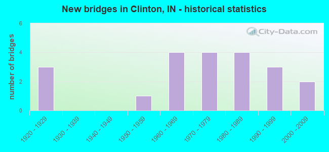
- New bridges - historical statistics
- 31920-1929
- 11950-1959
- 41960-1969
- 41970-1979
- 41980-1989
- 31990-1999
- 22000-2009

- Reconstructed bridges - Historical Statistics
- 31980-1989
- 01990-1999
- 12000-2009
- 22010-2019
- 12020-2022


- Bridge Condition - Deck
- 33.3%Good
- 44.4%Satisfactory
- 22.2%Fair

- Bridge Condition - Superstructure
- 5.3%Very good
- 47.4%Good
- 26.3%Satisfactory
- 21.1%Fair

- Bridge Condition - Substructure
- 21.1%Very good
- 31.6%Good
- 36.8%Satisfactory
- 5.3%Fair
- 5.3%Poor

- Bridge Condition - Channel
- 16.7%Very good
- 27.8%Good
- 33.3%Satisfactory
- 22.2%Fair
Find on map >> Show street view
Structure Number: 1784, Location: 01.15 E SR 43 (Lat: 39.168311, Lng: -86.660750), Route carried "on" structure: State highway 48, Year Built: 1987, Status: Open, Structure Length: 3.93m (12.89ft), Average Daily Traffic: 5,419 (year 2004), Truck Traffic: 10%, Average Future Daily Traffic: 9,109 (year 2033), Design Load: HS 20, Features Intersected: RICHLAND CREEK
Minimum Vertical Clearance: 30+ m (98+ ft), Kilometerpoint: 1.851, Lanes on structure: 2, Owner: State Highway Agency, Approaching Roadway Width: 13.4m (44.0ft), Skew: 4 degrees, Material/Design: Prestressed concrete continuous, Design/Construction: Stringer/Multi-beam, Number Of Spans In Main Unit: 3, Length of Maximum Span: 12.8m (42.0ft), Curb-To-Curb Width: 13.4m (44.0ft), Out-to-Out Width: 14.3m (46.9ft)
Condition: Deck: Fair, Superstructure: Good, Substructure: Good, Channel: Satisfactory, Operating Rating: 54.7 metric tons, Method Used To Determine Operating Rating: Load Factor (LF), Inventory Rating: 32.2 metric tons, Method Used To Determine Inventory Rating: Load Factor (LF), Structural Evaluation: Better than present minimum criteria, Deck Geometry: Equal to present minimum criteria, Waterway Adequacy: Better than present minimum criteria, Approach Roadway Alignment: Equal to present desirable criteria, Designated Inspection Frequency: Every 24 months, Inspection Date: November 2021, Deck Structure Type: Concrete Cast-file-Place, Wearing Surface/Protective System: Wearing Surface: Monolithic Concrete, Deck Protection: Epoxy Coated Reinforcing
Find on map >> Show street view
Structure Number: 2265, Location: 01.31 N SR 163 (Lat: 39.674689, Lng: -87.422211), Route carried "on" structure: State highway 63, Year Built: 1964, Year Reconstructed: 1985, Status: Open, Structure Length: 4.69m (15.39ft), Average Daily Traffic: 6,073 (year 2004), Truck Traffic: 5%, Average Future Daily Traffic: 8,557 (year 2032), Design Load: HS 20, Features Intersected: FEATHER CREEK
Minimum Vertical Clearance: 30+ m (98+ ft), Kilometerpoint: 7.805, Lanes on structure: 2, Base Highway Network: Yes (, Subroute: 1), Owner: State Highway Agency, Approaching Roadway Width: 11.6m (38.1ft), Material/Design: Concrete, Design/Construction: Stringer/Multi-beam, Number Of Spans In Main Unit: 4, Length of Maximum Span: 11.6m (38.1ft), Curb or Sidewalk Widths: Left: 0.1m (0.3ft), Right: 0.1m (0.3ft), Curb-To-Curb Width: 9.1m (29.9ft), Out-to-Out Width: 11.1m (36.4ft)
Condition: Deck: Satisfactory, Superstructure: Satisfactory, Substructure: Satisfactory, Channel: Very good, Operating Rating: 68.2 metric tons, Method Used To Determine Operating Rating: Load Factor (LF), Inventory Rating: 40.9 metric tons, Method Used To Determine Inventory Rating: Load Factor (LF), Structural Evaluation: Equal to present minimum criteria, Deck Geometry: High priority of replacement, Waterway Adequacy: Superior to present desirable criteria, Approach Roadway Alignment: Equal to present desirable criteria, Designated Inspection Frequency: Every 24 months, Inspection Date: January 2021, Deck Structure Type: Concrete Cast-file-Place, Wearing Surface/Protective System: Wearing Surface: Latex Concrete
Find on map >> Show street view
Structure Number: 22655, Location: 01.31 N SR 163 (Lat: 39.674819, Lng: -87.422411), Route carried "on" structure: State highway 63, Year Built: 1974, Year Reconstructed: 2012, Status: Open, Structure Length: 5.00m (16.40ft), Average Daily Traffic: 5,148 (year 2016), Truck Traffic: 17%, Average Future Daily Traffic: 8,557 (year 2032), Design Load: HS 20, Features Intersected: FEATHER CREEK
Minimum Vertical Clearance: 30+ m (98+ ft), Kilometerpoint: 7.805, Lanes on structure: 2, Base Highway Network: Yes (, Subroute: 1), Owner: State Highway Agency, Approaching Roadway Width: 11.6m (38.1ft), Material/Design: Steel continuous, Design/Construction: Stringer/Multi-beam, Number Of Spans In Main Unit: 2, Length of Maximum Span: 24.8m (81.4ft), Curb-To-Curb Width: 12.2m (40.0ft), Out-to-Out Width: 13.0m (42.7ft)
Condition: Deck: Satisfactory, Superstructure: Fair, Substructure: Good, Channel: Satisfactory, Operating Rating: 37.6 metric tons, Method Used To Determine Operating Rating: Load and Resistance Factor Rating (LRFR) rating reported by rating factor(RF) method using HL-93 loadings, Inventory Rating: 28.8 metric tons, Method Used To Determine Inventory Rating: Load and Resistance Factor Rating (LRFR) rating reported by rating factor(RF) method using HL-93 loadings, Structural Evaluation: Somewhat better than minimum adequacy, Deck Geometry: Better than present minimum criteria, Waterway Adequacy: Superior to present desirable criteria, Approach Roadway Alignment: Equal to present desirable criteria, Designated Inspection Frequency: Every 24 months, Inspection Date: January 2021, Deck Structure Type: Concrete Cast-file-Place, Wearing Surface/Protective System: Wearing Surface: Latex Concrete
Find on map >> Show street view
Structure Number: 22665, Location: 02.80 N SR 163 (Lat: 39.691681, Lng: -87.404800), Route carried "on" structure: State highway 63, Year Built: 1974, Year Reconstructed: 1988, Status: Open, Structure Length: 4.94m (16.21ft), Average Daily Traffic: 5,867 (year 2004), Truck Traffic: 10%, Average Future Daily Traffic: 8,126 (year 2034), Design Load: HS 20, Features Intersected: NORTON CREEK
Minimum Vertical Clearance: 30+ m (98+ ft), Kilometerpoint: 10.203, Lanes on structure: 2, Base Highway Network: Yes (, Subroute: 1), Owner: State Highway Agency, Approaching Roadway Width: 11.9m (39.0ft), Skew: 1 degrees, Material/Design: Steel continuous, Design/Construction: Stringer/Multi-beam, Number Of Spans In Main Unit: 3, Length of Maximum Span: 18.3m (60.0ft), Curb-To-Curb Width: 12.0m (39.4ft), Out-to-Out Width: 13.0m (42.7ft)
Condition: Deck: Satisfactory, Superstructure: Good, Substructure: Good, Channel: Good, Operating Rating: 42.8 metric tons, Method Used To Determine Operating Rating: Load and Resistance Factor Rating (LRFR) rating reported by rating factor(RF) method using HL-93 loadings, Inventory Rating: 33.0 metric tons, Method Used To Determine Inventory Rating: Load and Resistance Factor Rating (LRFR) rating reported by rating factor(RF) method using HL-93 loadings, Structural Evaluation: Better than present minimum criteria, Deck Geometry: Better than present minimum criteria, Waterway Adequacy: Better than present minimum criteria, Approach Roadway Alignment: Equal to present desirable criteria, Designated Inspection Frequency: Every 24 months, Inspection Date: January 2021, Deck Structure Type: Concrete Cast-file-Place, Wearing Surface/Protective System: Wearing Surface: Latex Concrete
Find on map >> Show street view
Structure Number: 2843, Location: 01.00 S US 41 (Lat: 39.656489, Lng: -87.394769), Route carried "on" structure: State highway 163, Year Built: 1964, Year Reconstructed: 2020, Status: Open, Structure Length: 32.72m (107.35ft), Average Daily Traffic: 6,850 (year 2018), Truck Traffic: 4%, Average Future Daily Traffic: 6,990 (year 2038), Design Load: HS 20, Features Intersected: WABASH RIVER
Minimum Vertical Clearance: 30+ m (98+ ft), Kilometerpoint: 12.633, Lanes on structure: 2, Owner: State Highway Agency, Approaching Roadway Width: 10.5m (34.4ft), Skew: 1 degrees, Material/Design: Steel continuous, Design/Construction: Stringer/Multi-beam, Number Of Spans In Main Unit: 5, Number Of Approach Spans: 4, Length of Maximum Span: 48.8m (160.1ft), Curb-To-Curb Width: 10.5m (34.4ft), Out-to-Out Width: 11.1m (36.4ft)
Condition: Deck: Good, Superstructure: Satisfactory, Substructure: Good, Channel: Satisfactory, Operating Rating: 48.6 metric tons, Method Used To Determine Operating Rating: Load Factor (LF), Inventory Rating: 28.4 metric tons, Method Used To Determine Inventory Rating: Load Factor (LF), Structural Evaluation: Equal to present minimum criteria, Deck Geometry: Meets minimum limits, Waterway Adequacy: Superior to present desirable criteria, Approach Roadway Alignment: Equal to present desirable criteria, Designated Inspection Frequency: Every 24 months, Underwater Inspection Frequency: Every 60 months, Inspection Date: April 2021, Underwater Inspection Date: October 2017, Deck Structure Type: Concrete Cast-file-Place, Wearing Surface/Protective System: Wearing Surface: Monolithic Concrete, Deck Protection: Epoxy Coated Reinforcing
Find on map >> Show street view
Structure Number: 3448, Location: 00.18 W SR 111 (Lat: 38.284319, Lng: -85.828089), Route carried "on" structure: Interstate 64, Year Built: 1960, Year Reconstructed: 1992, Status: Open, Structure Length: 4.76m (15.62ft), Average Daily Traffic: 65,848 (year 2004), Truck Traffic: 5%, Average Future Daily Traffic: 137,859 (year 2031), Design Load: HS 20+Mod, Features Intersected: SR 62X/SPRING STREET
Minimum Vertical Clearance: 30+ m (98+ ft), Kilometerpoint: 197.821, Lanes on structure: 8, Lanes under structure: 3, Base Highway Network: Yes (, Subroute: 1), Owner: State Highway Agency, Approaching Roadway Width: 36.5m (119.8ft), Skew: 21 degrees, Material/Design: Steel continuous, Design/Construction: Stringer/Multi-beam, Number Of Spans In Main Unit: 3, Length of Maximum Span: 21.5m (70.5ft), Curb-To-Curb Width: 36.5m (119.8ft), Out-to-Out Width: 38.1m (125.0ft)
Condition: Deck: Satisfactory, Superstructure: Satisfactory, Substructure: Satisfactory, Operating Rating: 53.5 metric tons, Method Used To Determine Operating Rating: Load and Resistance Factor Rating (LRFR) rating reported by rating factor(RF) method using HL-93 loadings, Inventory Rating: 41.1 metric tons, Method Used To Determine Inventory Rating: Load and Resistance Factor Rating (LRFR) rating reported by rating factor(RF) method using HL-93 loadings, Structural Evaluation: Equal to present minimum criteria, Deck Geometry: Better than present minimum criteria, Underclear: High priority of corrective action, Approach Roadway Alignment: Equal to present desirable criteria, Designated Inspection Frequency: Every 24 months, Other Special Inspection Frequency: Every 48 months, Inspection Date: November 2021, Other Special Inspection Date: August 2020, Deck Structure Type: Concrete Cast-file-Place, Wearing Surface/Protective System: Wearing Surface: Monolithic Concrete, Deck Protection: Epoxy Coated Reinforcing
Find on map >> Show street view
Structure Number: 3577, Location: 02.86 S SR 44 (Lat: 39.445719, Lng: -85.990808), Route carried "on" structure: Interstate 65, Year Built: 1970, Year Reconstructed: 2016, Status: Open, Structure Length: 2.49m (8.17ft), Average Daily Traffic: 19,065 (year 2015), Truck Traffic: 26%, Average Future Daily Traffic: 28,329 (year 2035), Design Load: HS 20+Mod, Features Intersected: AMITY DITCH
Minimum Vertical Clearance: 30+ m (98+ ft), Kilometerpoint: 139.498, Lanes on structure: 2, Base Highway Network: Yes (, Subroute: 1), Owner: State Highway Agency, Approaching Roadway Width: 12.8m (42.0ft), Skew: 3 degrees, Material/Design: Concrete continuous, Design/Construction: Slab, Number Of Spans In Main Unit: 3, Length of Maximum Span: 9.8m (32.2ft), Curb-To-Curb Width: 12.1m (39.7ft), Out-to-Out Width: 13.0m (42.7ft)
Condition: Deck: Satisfactory, Superstructure: Satisfactory, Substructure: Very good, Channel: Very good, Operating Rating: 50.9 metric tons, Method Used To Determine Operating Rating: Load and Resistance Factor Rating (LRFR) rating reported by rating factor(RF) method using HL-93 loadings, Inventory Rating: 39.2 metric tons, Method Used To Determine Inventory Rating: Load and Resistance Factor Rating (LRFR) rating reported by rating factor(RF) method using HL-93 loadings, Structural Evaluation: Equal to present minimum criteria, Deck Geometry: Equal to present minimum criteria, Waterway Adequacy: Superior to present desirable criteria, Approach Roadway Alignment: Equal to present desirable criteria, Designated Inspection Frequency: Every 24 months, Inspection Date: August 2020, Deck Structure Type: Concrete Cast-file-Place, Wearing Surface/Protective System: Wearing Surface: Latex Concrete
Find on map >> Show street view
Structure Number: 3578, Location: 02.86 S SR 44 (Lat: 39.445450, Lng: -85.990936), Route carried "on" structure: Interstate 65, Year Built: 1970, Year Reconstructed: 2016, Status: Open, Structure Length: 2.49m (8.17ft), Average Daily Traffic: 22,112 (year 2015), Truck Traffic: 26%, Average Future Daily Traffic: 32,856 (year 2035), Design Load: HS 20+Mod, Features Intersected: AMITY DITCH
Minimum Vertical Clearance: 30+ m (98+ ft), Kilometerpoint: 139.498, Lanes on structure: 2, Base Highway Network: Yes (, Subroute: 1), Owner: State Highway Agency, Approaching Roadway Width: 12.8m (42.0ft), Skew: 3 degrees, Material/Design: Concrete continuous, Design/Construction: Slab, Number Of Spans In Main Unit: 3, Length of Maximum Span: 9.8m (32.2ft), Curb-To-Curb Width: 12.1m (39.7ft), Out-to-Out Width: 13.0m (42.7ft)
Condition: Deck: Good, Superstructure: Good, Substructure: Very good, Channel: Very good, Operating Rating: 50.9 metric tons, Method Used To Determine Operating Rating: Load and Resistance Factor Rating (LRFR) rating reported by rating factor(RF) method using HL-93 loadings, Inventory Rating: 39.2 metric tons, Method Used To Determine Inventory Rating: Load and Resistance Factor Rating (LRFR) rating reported by rating factor(RF) method using HL-93 loadings, Structural Evaluation: Better than present minimum criteria, Deck Geometry: Equal to present minimum criteria, Waterway Adequacy: Superior to present desirable criteria, Approach Roadway Alignment: Equal to present desirable criteria, Designated Inspection Frequency: Every 24 months, Inspection Date: August 2020, Deck Structure Type: Concrete Cast-file-Place, Wearing Surface/Protective System: Wearing Surface: Latex Concrete
Find on map >> Show street view
Structure Number: 6100049, Location: 00.70 W of US 41 (Lat: 39.681161, Lng: -87.368269), Route carried "on" structure: County highway 108, Year Built: 2000, Status: Open, Structure Length: 0.91m (2.99ft), Average Daily Traffic: 5 (year 2018), Truck Traffic: 5%, Average Future Daily Traffic: 6 (year 2038), Features Intersected: LYFORD DIKE Ditch, Facility Carried by Structure: CR 610S
Minimum Vertical Clearance: 30+ m (98+ ft), Kilometerpoint: 0.000, Lanes on structure: 2, Owner: County Highway Agency, Approaching Roadway Width: 5.2m (17.1ft), Material/Design: Concrete, Design/Construction: Channel Beam, Number Of Spans In Main Unit: 1, Length of Maximum Span: 8.0m (26.2ft), Curb or Sidewalk Widths: Left: 0.3m (1.0ft), Right: 0.3m (1.0ft), Curb-To-Curb Width: 6.2m (20.3ft), Out-to-Out Width: 6.8m (22.3ft)
Condition: Deck: Satisfactory, Superstructure: Satisfactory, Substructure: Good, Channel: Satisfactory, Operating Rating: 66.3 metric tons, Method Used To Determine Operating Rating: Load Factor (LF), Inventory Rating: 39.7 metric tons, Method Used To Determine Inventory Rating: Load Factor (LF), Structural Evaluation: Equal to present minimum criteria, Deck Geometry: Somewhat better than minimum adequacy, Waterway Adequacy: High priority of corrective action, Approach Roadway Alignment: Equal to present desirable criteria, Designated Inspection Frequency: Every 24 months, Inspection Date: April 2020, Deck Structure Type: Concrete Precast Panels, Wearing Surface/Protective System: Wearing Surface: Gravel
Find on map >> Show street view
Structure Number: 830007, Location: 00.10 S of North St (Lat: 39.662469, Lng: -87.403981), Route carried "on" structure: City street , Year Built: 1927, Status: Posted for load, Structure Length: 1.36m (4.46ft), Average Daily Traffic: 249 (year 2017), Truck Traffic: 3%, Average Future Daily Traffic: 309 (year 2037), Features Intersected: FEATHER Creek, Facility Carried by Structure: 6th St
Minimum Vertical Clearance: 30+ m (98+ ft), Kilometerpoint: 0.000, Lanes on structure: 2, Owner: County Highway Agency, Approaching Roadway Width: 5.5m (18.0ft), Material/Design: Concrete, Design/Construction: Stringer/Multi-beam, Number Of Spans In Main Unit: 1, Length of Maximum Span: 12.1m (39.7ft), Curb-To-Curb Width: 5.1m (16.7ft), Out-to-Out Width: 6.6m (21.7ft)
Condition: Deck: Fair, Superstructure: Fair, Substructure: Satisfactory, Channel: Satisfactory, Operating Rating: 23.0 metric tons, Method Used To Determine Operating Rating: Load Factor (LF), Inventory Rating: 13.7 metric tons, Method Used To Determine Inventory Rating: Load Factor (LF), Structural Evaluation: Meets minimum limits, Deck Geometry: High priority of replacement, Waterway Adequacy: Better than present minimum criteria, Approach Roadway Alignment: Equal to present desirable criteria, Bridge Posting: Required (Relationship of Operating Rating to Maximum Legal Load: > 39.9% below), Length Of Structure Improvement: 2.29m (7.51ft), Designated Inspection Frequency: Every 24 months, Inspection Date: August 2021, Bridge Improvement Cost: $564,000, Roadway Improvement Cost: $169,000, Total Project Cost: $989,000 ( Estimate for 2021), Deck Structure Type: Concrete Cast-file-Place, Wearing Surface/Protective System: Wearing Surface: Bituminous
Find on map >> Show street view
Structure Number: 8300072, Location: 00.10 S of North St (Lat: 39.662319, Lng: -87.406781), Route carried "on" structure: City street , Year Built: 1982, Status: Open, Structure Length: 1.28m (4.20ft), Average Daily Traffic: 249 (year 2017), Truck Traffic: 3%, Average Future Daily Traffic: 309 (year 2037), Design Load: HS 20, Features Intersected: FEATHER Creek, Facility Carried by Structure: 8th St
Minimum Vertical Clearance: 30+ m (98+ ft), Kilometerpoint: 0.000, Lanes on structure: 2, Owner: County Highway Agency, Approaching Roadway Width: 6.7m (22.0ft), Material/Design: Prestressed concrete, Design/Construction: Box Beam or Girders - Multiple, Number Of Spans In Main Unit: 1, Length of Maximum Span: 12.1m (39.7ft), Curb-To-Curb Width: 8.0m (26.2ft), Out-to-Out Width: 8.1m (26.6ft)
Condition: Deck: Good, Superstructure: Good, Substructure: Satisfactory, Channel: Good, Operating Rating: 49.0 metric tons, Method Used To Determine Operating Rating: Load Factor (LF), Inventory Rating: 27.2 metric tons, Method Used To Determine Inventory Rating: Load Factor (LF), Structural Evaluation: Equal to present minimum criteria, Deck Geometry: Somewhat better than minimum adequacy, Waterway Adequacy: Equal to present minimum criteria, Approach Roadway Alignment: Equal to present desirable criteria, Designated Inspection Frequency: Every 24 months, Inspection Date: August 2021, Deck Structure Type: Concrete Precast Panels, Wearing Surface/Protective System: Wearing Surface: Bituminous
Find on map >> Show street view
Structure Number: 8300073, Location: 00.10 S of North St (Lat: 39.661739, Lng: -87.408269), Route carried "on" structure: City street , Year Built: 1997, Status: Open, Structure Length: 1.12m (3.67ft), Average Daily Traffic: 1,491 (year 2017), Truck Traffic: 7%, Average Future Daily Traffic: 1,852 (year 2037), Design Load: HS 20, Features Intersected: FEATHER Creek, Facility Carried by Structure: 9th St
Minimum Vertical Clearance: 30+ m (98+ ft), Kilometerpoint: 0.000, Lanes on structure: 2, Owner: County Highway Agency, Approaching Roadway Width: 11.3m (37.1ft), Skew: 3 degrees, Material/Design: Prestressed concrete, Design/Construction: Box Beam or Girders - Single/Spread, Number Of Spans In Main Unit: 1, Length of Maximum Span: 9.8m (32.2ft), Curb or Sidewalk Widths: Left: 1.6m (5.2ft), Right: 1.6m (5.2ft), Curb-To-Curb Width: 11.5m (37.7ft), Out-to-Out Width: 15.9m (52.2ft)
Condition: Deck: Satisfactory, Superstructure: Good, Substructure: Very good, Channel: Good, Operating Rating: 56.2 metric tons, Method Used To Determine Operating Rating: Load Factor (LF), Inventory Rating: 33.6 metric tons, Method Used To Determine Inventory Rating: Load Factor (LF), Structural Evaluation: Better than present minimum criteria, Deck Geometry: Equal to present minimum criteria, Waterway Adequacy: Better than present minimum criteria, Approach Roadway Alignment: Equal to present desirable criteria, Designated Inspection Frequency: Every 24 months, Inspection Date: August 2021, Deck Structure Type: Concrete Cast-file-Place, Wearing Surface/Protective System: Wearing Surface: Monolithic Concrete, Deck Protection: Epoxy Coated Reinforcing
Find on map >> Show street view
Structure Number: 8300074, Location: 00.10 N of SYCAMORE (Lat: 39.662489, Lng: -87.411069), Route carried "on" structure: City street , Year Built: 1929, Status: Posted for load, Structure Length: 0.69m (2.26ft), Average Daily Traffic: 249 (year 2017), Truck Traffic: 3%, Average Future Daily Traffic: 309 (year 2037), Features Intersected: LOST CREEK, Facility Carried by Structure: 11TH ST
Minimum Vertical Clearance: 30+ m (98+ ft), Kilometerpoint: 0.000, Lanes on structure: 2, Owner: County Highway Agency, Approaching Roadway Width: 5.2m (17.1ft), Material/Design: Concrete, Design/Construction: Slab, Number Of Spans In Main Unit: 1, Length of Maximum Span: 6.1m (20.0ft), Curb-To-Curb Width: 5.7m (18.7ft), Out-to-Out Width: 6.3m (20.7ft)
Condition: Deck: Fair, Superstructure: Fair, Substructure: Satisfactory, Channel: Fair, Operating Rating: 38.2 metric tons, Method Used To Determine Operating Rating: Load Factor (LF), Inventory Rating: 22.9 metric tons, Method Used To Determine Inventory Rating: Load Factor (LF), Structural Evaluation: Somewhat better than minimum adequacy, Deck Geometry: High priority of corrective action, Waterway Adequacy: Equal to present minimum criteria, Approach Roadway Alignment: Equal to present desirable criteria, Length Of Structure Improvement: 1.37m (4.49ft), Designated Inspection Frequency: Every 24 months, Inspection Date: August 2021, Bridge Improvement Cost: $322,000, Roadway Improvement Cost: $97,000, Total Project Cost: $565,000 ( Estimate for 2021), Deck Structure Type: Concrete Cast-file-Place, Wearing Surface/Protective System: Wearing Surface: Bituminous
Find on map >> Show street view
Structure Number: 8300075, Location: 00.10 N of SYCAMORE (Lat: 39.662119, Lng: -87.412469), Route carried "on" structure: City street , Year Built: 1929, Status: Posted for load, Structure Length: 0.73m (2.40ft), Average Daily Traffic: 249 (year 2017), Truck Traffic: 3%, Average Future Daily Traffic: 309 (year 2037), Features Intersected: LOST CREEK, Facility Carried by Structure: 12TH ST
Minimum Vertical Clearance: 30+ m (98+ ft), Kilometerpoint: 0.000, Lanes on structure: 2, Owner: County Highway Agency, Approaching Roadway Width: 4.9m (16.1ft), Skew: 4 degrees, Material/Design: Concrete, Design/Construction: Slab, Number Of Spans In Main Unit: 1, Length of Maximum Span: 6.1m (20.0ft), Curb-To-Curb Width: 5.8m (19.0ft), Out-to-Out Width: 6.4m (21.0ft)
Condition: Deck: Fair, Superstructure: Fair, Substructure: Fair, Channel: Fair, Operating Rating: 27.7 metric tons, Method Used To Determine Operating Rating: Load Factor (LF), Inventory Rating: 16.6 metric tons, Method Used To Determine Inventory Rating: Load Factor (LF), Structural Evaluation: Somewhat better than minimum adequacy, Deck Geometry: High priority of corrective action, Waterway Adequacy: Equal to present minimum criteria, Approach Roadway Alignment: Equal to present desirable criteria, Bridge Posting: Required (Relationship of Operating Rating to Maximum Legal Load: > 39.9% below), Length Of Structure Improvement: 1.46m (4.79ft), Designated Inspection Frequency: Every 24 months, Inspection Date: August 2021, Bridge Improvement Cost: $345,000, Roadway Improvement Cost: $104,000, Total Project Cost: $606,000 ( Estimate for 2021), Deck Structure Type: Concrete Cast-file-Place, Wearing Surface/Protective System: Wearing Surface: Bituminous
Find on map >> Show street view
Structure Number: 8300076, Location: 00.10 E of 6th St (Lat: 39.662650, Lng: -87.403389), Route carried "on" structure: City street , Year Built: 1982, Status: Open, Structure Length: 1.03m (3.38ft), Average Daily Traffic: 249 (year 2017), Truck Traffic: 3%, Average Future Daily Traffic: 309 (year 2037), Design Load: HS 20, Features Intersected: FEATHER CREEK, Facility Carried by Structure: NORTH ST
Minimum Vertical Clearance: 30+ m (98+ ft), Kilometerpoint: 0.000, Lanes on structure: 2, Owner: County Highway Agency, Approaching Roadway Width: 6.7m (22.0ft), Skew: 1 degrees, Material/Design: Prestressed concrete, Design/Construction: Box Beam or Girders - Multiple, Number Of Spans In Main Unit: 1, Length of Maximum Span: 9.1m (29.9ft), Curb or Sidewalk Widths: Left: 0.0m, Right: 1.3m (4.3ft), Curb-To-Curb Width: 8.0m (26.2ft), Out-to-Out Width: 9.5m (31.2ft)
Condition: Deck: Satisfactory, Superstructure: Good, Substructure: Poor, Channel: Fair, Operating Rating: 54.4 metric tons, Method Used To Determine Operating Rating: Load Factor (LF), Inventory Rating: 32.7 metric tons, Method Used To Determine Inventory Rating: Load Factor (LF), Structural Evaluation: Meets minimum limits, Deck Geometry: Somewhat better than minimum adequacy, Waterway Adequacy: Better than present minimum criteria, Approach Roadway Alignment: Equal to present desirable criteria, Designated Inspection Frequency: Every 24 months, Inspection Date: August 2021, Deck Structure Type: Concrete Precast Panels, Wearing Surface/Protective System: Wearing Surface: Bituminous
Find on map >> Show street view
Structure Number: 8300077, Location: 00.10 W of TOWNE St (Lat: 39.663700, Lng: -87.410061), Route carried "on" structure: City street , Year Built: 1988, Status: Open, Structure Length: 1.16m (3.81ft), Average Daily Traffic: 405 (year 2017), Truck Traffic: 3%, Average Future Daily Traffic: 503 (year 2037), Design Load: HS 20, Features Intersected: FEATHER Creek, Facility Carried by Structure: ANDERSON St
Minimum Vertical Clearance: 30+ m (98+ ft), Kilometerpoint: 0.000, Lanes on structure: 2, Owner: County Highway Agency, Approaching Roadway Width: 6.7m (22.0ft), Skew: 3 degrees, Material/Design: Prestressed concrete, Design/Construction: Box Beam or Girders - Multiple, Number Of Spans In Main Unit: 1, Length of Maximum Span: 10.1m (33.1ft), Curb-To-Curb Width: 8.0m (26.2ft), Out-to-Out Width: 8.0m (26.2ft)
Condition: Deck: Good, Superstructure: Good, Substructure: Satisfactory, Channel: Fair, Operating Rating: 55.3 metric tons, Method Used To Determine Operating Rating: Load Factor (LF), Inventory Rating: 33.6 metric tons, Method Used To Determine Inventory Rating: Load Factor (LF), Structural Evaluation: Equal to present minimum criteria, Deck Geometry: Somewhat better than minimum adequacy, Waterway Adequacy: Better than present minimum criteria, Approach Roadway Alignment: Equal to present desirable criteria, Designated Inspection Frequency: Every 24 months, Inspection Date: August 2021, Deck Structure Type: Concrete Precast Panels, Wearing Surface/Protective System: Wearing Surface: Bituminous
Find on map >> Show street view
Structure Number: 8300079, Location: 00.80 S SR 63 (Lat: 39.687939, Lng: -87.398969), Route carried "on" structure: City street 177, Year Built: 1950, Status: Open, Structure Length: 1.91m (6.27ft), Average Daily Traffic: 3,357 (year 2017), Truck Traffic: 6%, Average Future Daily Traffic: 4,169 (year 2037), Features Intersected: NORTON CREEK, Facility Carried by Structure: CR 350E
Minimum Vertical Clearance: 30+ m (98+ ft), Kilometerpoint: 0.000, Lanes on structure: 2, Owner: County Highway Agency, Approaching Roadway Width: 6.1m (20.0ft), Material/Design: Concrete, Design/Construction: Arch - Deck, Number Of Spans In Main Unit: 1, Length of Maximum Span: 17.5m (57.4ft), Curb-To-Curb Width: 9.8m (32.2ft), Out-to-Out Width: 10.7m (35.1ft)
Condition: Superstructure: Good, Substructure: Good, Channel: Satisfactory, Operating Rating: 44.4 metric tons, Method Used To Determine Operating Rating: Field evaluation and documented engineering judgment, Inventory Rating: 32.7 metric tons, Method Used To Determine Inventory Rating: Field evaluation and documented engineering judgment, Structural Evaluation: Better than present minimum criteria, Deck Geometry: Meets minimum limits, Waterway Adequacy: Better than present minimum criteria, Approach Roadway Alignment: Equal to present desirable criteria, Designated Inspection Frequency: Every 24 months, Inspection Date: August 2021, Deck Structure Type: Concrete Cast-file-Place, Wearing Surface/Protective System: Wearing Surface: Bituminous
Find on map >> Show street view
Structure Number: 830008, Location: 01.10 N of SR 163 (Lat: 39.672200, Lng: -87.399069), Route carried "on" structure: City street 177, Year Built: 1999, Status: Open, Structure Length: 1.87m (6.14ft), Average Daily Traffic: 3,357 (year 2017), Truck Traffic: 8%, Average Future Daily Traffic: 4,169 (year 2037), Design Load: HS 20, Features Intersected: FEATHER Creek, Facility Carried by Structure: CR 350E
Minimum Vertical Clearance: 30+ m (98+ ft), Kilometerpoint: 0.000, Lanes on structure: 2, Owner: County Highway Agency, Approaching Roadway Width: 6.7m (22.0ft), Skew: 3 degrees, Material/Design: Wood or Timber, Design/Construction: Slab, Number Of Spans In Main Unit: 3, Length of Maximum Span: 7.9m (25.9ft), Curb-To-Curb Width: 9.8m (32.2ft), Out-to-Out Width: 10.2m (33.5ft)
Condition: Deck: Good, Superstructure: Good, Substructure: Satisfactory, Channel: Good, Operating Rating: 66.7 metric tons, Method Used To Determine Operating Rating: Allowable Stress (AS), Inventory Rating: 48.3 metric tons, Method Used To Determine Inventory Rating: Allowable Stress (AS), Structural Evaluation: Equal to present minimum criteria, Deck Geometry: Meets minimum limits, Waterway Adequacy: Better than present minimum criteria, Approach Roadway Alignment: Equal to present desirable criteria, Designated Inspection Frequency: Every 24 months, Inspection Date: August 2021, Deck Structure Type: Wood or Timber, Wearing Surface/Protective System: Wearing Surface: Bituminous
Find on map >> Show street view
Structure Number: 830009, Location: 00.05 S OF NORTH STREET (Lat: 39.662289, Lng: -87.405381), Route carried "on" structure: County highway , Year Built: 2009, Status: Open, Structure Length: 1.51m (4.95ft), Average Daily Traffic: 374 (year 2017), Truck Traffic: 5%, Average Future Daily Traffic: 465 (year 2037), Design Load: HS 20, Features Intersected: FEATHER CREEK, Facility Carried by Structure: 7th STREET
Minimum Vertical Clearance: 30+ m (98+ ft), Kilometerpoint: 0.000, Lanes on structure: 2, Owner: County Highway Agency, Approaching Roadway Width: 7.0m (23.0ft), Material/Design: Steel, Design/Construction: Stringer/Multi-beam, Number Of Spans In Main Unit: 1, Length of Maximum Span: 14.9m (48.9ft), Curb-To-Curb Width: 7.2m (23.6ft), Out-to-Out Width: 7.3m (24.0ft)
Condition: Deck: Good, Superstructure: Very good, Substructure: Very good, Channel: Good, Operating Rating: 59.9 metric tons, Method Used To Determine Operating Rating: Load Factor (LF), Inventory Rating: 35.4 metric tons, Method Used To Determine Inventory Rating: Load Factor (LF), Structural Evaluation: Equal to present desirable criteria, Deck Geometry: Meets minimum limits, Waterway Adequacy: Equal to present minimum criteria, Approach Roadway Alignment: Equal to present desirable criteria, Designated Inspection Frequency: Every 24 months, Inspection Date: August 2021, Deck Structure Type: Corrugated Steel, Wearing Surface/Protective System: Wearing Surface: Bituminous
Find on map >> Show street view
Structure Number: 1507, Location: 01.91 S SR 163 (Lat: 39.633369, Lng: -87.370322), Route carried "under" structure: US 41, Year Built: 1991, Structure Length: 0. m, Average Daily Traffic: 1,458 (year 2006), Truck Traffic: 16%, Features Intersected: US 41, Facility Carried by Structure: CSX RR
Minimum Vertical Clearance: 5.01m (16.44ft), Kilometerpoint: 2.816, Lanes under structure: 2, Material/Design: Steel, Design/Construction: Girder and Floorbeam System, Length of Maximum Span: 35.4m (116.1ft)
Find on map >> Show street view
Structure Number: 2844, Location: 00.71 S US 41 (Lat: 39.657861, Lng: -87.390372), Route carried "under" structure: State highway 163, Year Built: 1968, Structure Length: 0. m, Average Daily Traffic: 6,440 (year 2009), Truck Traffic: 4%, Features Intersected: SR 163, Facility Carried by Structure: CSX RR
Minimum Vertical Clearance: 4.80m (15.75ft), Kilometerpoint: 0.467, Lanes under structure: 2, Material/Design: Steel, Design/Construction: Stringer/Multi-beam, Length of Maximum Span: 14.3m (46.9ft)