Bridge Statistics for Clintonville, Pennsylvania (PA)
Condition, Traffic, Stress, Structural Evaluation, Project Costs
- National Bridge Inventory (NBI) Statistics
- 22Number of bridges
- 171ft / 51.9mTotal length
- $4,137,000Total costs
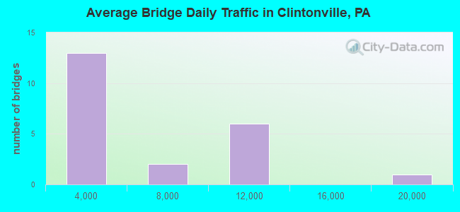
- 94,680Total average daily traffic
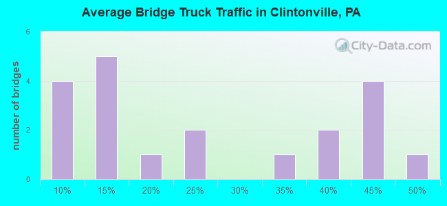
- 29,919Total average daily truck traffic
- National Bridge Inventory (NBI) Registered Bridges for Clintonville
- No street view available for this location
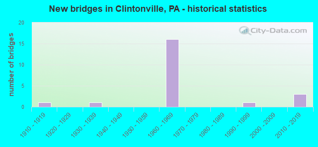
- New bridges - historical statistics
- 11910-1919
- 11930-1939
- 161960-1969
- 11990-1999
- 32010-2019
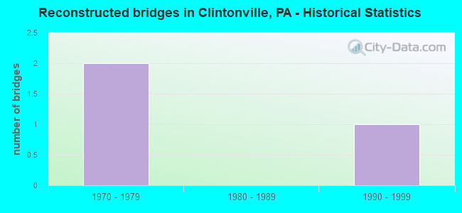
- Reconstructed bridges - Historical Statistics
- 21970-1979
- 01980-1989
- 11990-1999
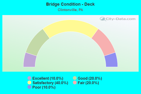
- Bridge Condition - Deck
- 10.0%Excellent
- 20.0%Good
- 40.0%Satisfactory
- 20.0%Fair
- 10.0%Poor
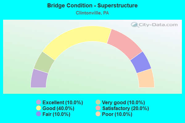
- Bridge Condition - Superstructure
- 10.0%Excellent
- 10.0%Very good
- 40.0%Good
- 20.0%Satisfactory
- 10.0%Fair
- 10.0%Poor
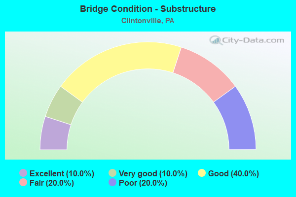
- Bridge Condition - Substructure
- 10.0%Excellent
- 10.0%Very good
- 40.0%Good
- 20.0%Fair
- 20.0%Poor
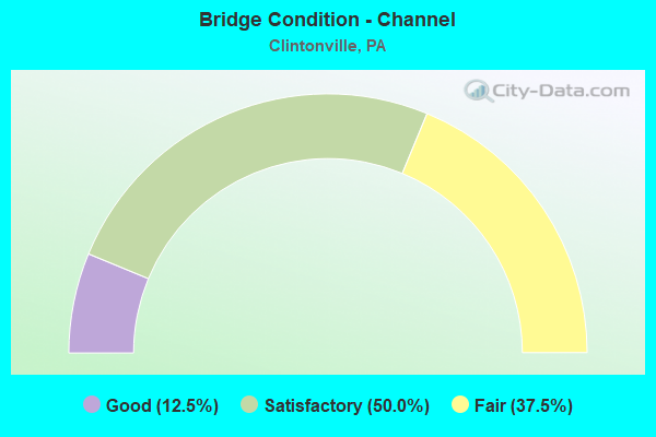
- Bridge Condition - Channel
- 12.5%Good
- 50.0%Satisfactory
- 37.5%Fair
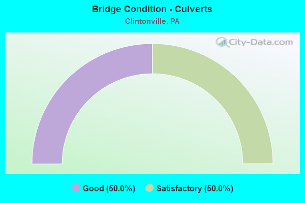
- Bridge Condition - Culverts
- 50.0%Good
- 50.0%Satisfactory
Find on map >> Show street view
Structure Number: 3371, Location: 100ft East of Rt 66 (Lat: 40.661944, Lng: -79.605908), Route carried "on" structure: City street , Year Built: 1999, Status: Open, Structure Length: 0.70m (2.30ft), Average Daily Traffic: 400 (year 2019), Truck Traffic: 9%, Average Future Daily Traffic: 560 (year 2039), Features Intersected: ELDER RUN, Facility Carried by Structure: T-413 FIREHALL RD
Minimum Vertical Clearance: 30+ m (98+ ft), Kilometerpoint: 0.000, Lanes on structure: 2, Owner: Town or Township Highway Agency, Approaching Roadway Width: 7.0m (23.0ft), Material/Design: Concrete, Design/Construction: Slab, Number Of Spans In Main Unit: 1, Length of Maximum Span: 6.4m (21.0ft), Curb-To-Curb Width: 7.4m (24.3ft), Out-to-Out Width: 7.9m (25.9ft)
Condition: Deck: Good, Superstructure: Good, Substructure: Good, Channel: Fair, Inventory Rating: 73.5 metric tons, Method Used To Determine Inventory Rating: Load Factor (LF), Structural Evaluation: Better than present minimum criteria, Deck Geometry: Somewhat better than minimum adequacy, Waterway Adequacy: Equal to present desirable criteria, Approach Roadway Alignment: Equal to present desirable criteria, Length Of Structure Improvement: 1.30m (4.27ft), Designated Inspection Frequency: Every 24 months, Inspection Date: April 2021, Wearing Surface/Protective System: Wearing Surface: Bituminous
Find on map >> Show street view
Structure Number: 18191, Location: FRANKLIN TOWNSHIP (Lat: 39.934447, Lng: -80.167450), Route carried "on" structure: State highway , Year Built: 1966, Status: Open, Structure Length: 7.92m (25.98ft), Average Daily Traffic: 268 (year 2019), Truck Traffic: 5%, Average Future Daily Traffic: 460 (year 2032), Design Load: HS 20+Mod, Features Intersected: SR 0079, Facility Carried by Structure: SR 1003
Minimum Vertical Clearance: 30.45m (99.90ft), Kilometerpoint: 4.968, Lanes on structure: 2, Lanes under structure: 8, Owner: State Highway Agency, Approaching Roadway Width: 6.7m (22.0ft), Skew: 3 degrees, Material/Design: Prestressed concrete, Design/Construction: Stringer/Multi-beam, Number Of Spans In Main Unit: 4, Length of Maximum Span: 24.4m (80.1ft), Curb or Sidewalk Widths: Left: 0.5m (1.6ft), Right: 0.5m (1.6ft), Curb-To-Curb Width: 8.5m (27.9ft), Out-to-Out Width: 10.2m (33.5ft)
Condition: Deck: Satisfactory, Superstructure: Satisfactory, Substructure: Fair, Operating Rating: 65.3 metric tons, Method Used To Determine Operating Rating: Load Factor (LF), Inventory Rating: 39.0 metric tons, Method Used To Determine Inventory Rating: Load Factor (LF), Structural Evaluation: Somewhat better than minimum adequacy, Deck Geometry: Equal to present minimum criteria, Underclear: Superior to present desirable criteria, Approach Roadway Alignment: Better than present minimum criteria, Length Of Structure Improvement: 8.70m (28.54ft), Designated Inspection Frequency: Every 24 months, Inspection Date: August 2020, Deck Structure Type: Concrete Cast-file-Place, Wearing Surface/Protective System: Wearing Surface: Bituminous
Find on map >> Show street view
Structure Number: 3371, Location: CLINTONVILLE BOROUGH (Lat: 41.196028, Lng: -79.885369), Route carried "on" structure: Interstate 80, Year Built: 1965, Status: Open, Structure Length: 0.94m (3.08ft), Average Daily Traffic: 17,285 (year 2020), Truck Traffic: 30%, Average Future Daily Traffic: 46,232 (year 2032), Design Load: HS 20+Mod, Features Intersected: OVER SCRUBGRASS CK TRIB
Minimum Vertical Clearance: 30+ m (98+ ft), Kilometerpoint: 9.292, Lanes on structure: 4, Base Highway Network: Yes, Owner: State Highway Agency, Approaching Roadway Width: 40.2m (131.9ft), Skew: 22 degrees, Material/Design: Concrete, Design/Construction: Culvert, Number Of Spans In Main Unit: 1, Length of Maximum Span: 9.4m (30.8ft)
Condition: Channel: Good, Culverts: Satisfactory, Operating Rating: 49.0 metric tons, Method Used To Determine Operating Rating: Field evaluation and documented engineering judgment, Inventory Rating: 32.7 metric tons, Method Used To Determine Inventory Rating: Field evaluation and documented engineering judgment, Structural Evaluation: Equal to present minimum criteria, Waterway Adequacy: Superior to present desirable criteria, Approach Roadway Alignment: Equal to present desirable criteria, Length Of Structure Improvement: 1.60m (5.25ft), Designated Inspection Frequency: Every 48 months, Inspection Date: July 2019
Find on map >> Show street view
Structure Number: 33711, Location: CLINTONVILLE BOROUGH (Lat: 41.180000, Lng: -79.881667), Route carried "on" structure: State highway , Year Built: 1965, Status: Open, Structure Length: 7.99m (26.21ft), Average Daily Traffic: 141 (year 2022), Truck Traffic: 6%, Average Future Daily Traffic: 225 (year 2032), Design Load: HS 20, Features Intersected: OVER SR 80,EB/WB, Facility Carried by Structure: SR 3101,PORTER RD
Minimum Vertical Clearance: 30+ m (98+ ft), Kilometerpoint: 0.000, Lanes on structure: 2, Lanes under structure: 8, Owner: State Highway Agency, Approaching Roadway Width: 5.5m (18.0ft), Skew: 3 degrees, Material/Design: Prestressed concrete, Design/Construction: Box Beam or Girders - Single/Spread, Number Of Spans In Main Unit: 5, Length of Maximum Span: 21.3m (69.9ft), Curb or Sidewalk Widths: Left: 0.5m (1.6ft), Right: 0.5m (1.6ft), Curb-To-Curb Width: 8.6m (28.2ft), Out-to-Out Width: 10.2m (33.5ft)
Condition: Deck: Good, Superstructure: Good, Substructure: Good, Operating Rating: 64.4 metric tons, Method Used To Determine Operating Rating: Load Factor (LF), Inventory Rating: 31.8 metric tons, Method Used To Determine Inventory Rating: Load Factor (LF), Structural Evaluation: Better than present minimum criteria, Deck Geometry: Equal to present minimum criteria, Underclear: Somewhat better than minimum adequacy, Approach Roadway Alignment: Better than present minimum criteria, Length Of Structure Improvement: 8.90m (29.20ft), Designated Inspection Frequency: Every 24 months, Inspection Date: September 2021, Bridge Improvement Cost: $24,000, Roadway Improvement Cost: $72,000, Total Project Cost: $329,000, Deck Structure Type: Concrete Cast-file-Place, Wearing Surface/Protective System: Wearing Surface: Monolithic Concrete
Find on map >> Show street view
Structure Number: 33712, Location: CLINTON TOWNSHIP (Lat: 41.192283, Lng: -79.844206), Route carried "on" structure: Interstate 80, Year Built: 1966, Year Reconstructed: 1982, Status: Open, Structure Length: 2.87m (9.42ft), Average Daily Traffic: 7,669 (year 2020), Truck Traffic: 40%, Average Future Daily Traffic: 15,357 (year 2032), Design Load: HS 20+Mod, Features Intersected: OVER T-388,COAL VALLEY
Minimum Vertical Clearance: 30+ m (98+ ft), Kilometerpoint: 13.350, Lanes on structure: 2, Lanes under structure: 2, Base Highway Network: Yes, Owner: State Highway Agency, Approaching Roadway Width: 11.6m (38.1ft), Skew: 11 degrees, Material/Design: Concrete, Design/Construction: Tee Beam, Number Of Spans In Main Unit: 3, Length of Maximum Span: 10.4m (34.1ft), Curb or Sidewalk Widths: Left: 0.2m (0.7ft), Right: 0.2m (0.7ft), Curb-To-Curb Width: 12.2m (40.0ft), Out-to-Out Width: 14.0m (45.9ft)
Condition: Deck: Satisfactory, Superstructure: Good, Substructure: Good, Operating Rating: 79.8 metric tons, Method Used To Determine Operating Rating: Load Factor (LF), Inventory Rating: 49.0 metric tons, Method Used To Determine Inventory Rating: Load Factor (LF), Structural Evaluation: Better than present minimum criteria, Deck Geometry: Better than present minimum criteria, Underclear: Somewhat better than minimum adequacy, Approach Roadway Alignment: Equal to present desirable criteria, Length Of Structure Improvement: 3.60m (11.81ft), Designated Inspection Frequency: Every 24 months, Inspection Date: July 2021, Wearing Surface/Protective System: Wearing Surface: Bituminous, Membrane: Preformed Fabric
Find on map >> Show street view
Structure Number: 33713, Location: SCRUBGRASS TOWNSHIP (Lat: 41.192600, Lng: -79.844197), Route carried "on" structure: Interstate 80, Year Built: 1966, Year Reconstructed: 1982, Status: Open, Structure Length: 3.11m (10.20ft), Average Daily Traffic: 9,634 (year 2020), Truck Traffic: 38%, Average Future Daily Traffic: 17,147 (year 2032), Design Load: HS 20+Mod, Features Intersected: OVER T-388,COAL VALLEY
Minimum Vertical Clearance: 30+ m (98+ ft), Kilometerpoint: 13.317, Lanes on structure: 2, Lanes under structure: 2, Base Highway Network: Yes, Owner: State Highway Agency, Approaching Roadway Width: 11.6m (38.1ft), Skew: 11 degrees, Material/Design: Concrete, Design/Construction: Tee Beam, Number Of Spans In Main Unit: 3, Length of Maximum Span: 10.4m (34.1ft), Curb or Sidewalk Widths: Left: 0.2m (0.7ft), Right: 0.2m (0.7ft), Curb-To-Curb Width: 12.2m (40.0ft), Out-to-Out Width: 14.0m (45.9ft)
Condition: Deck: Satisfactory, Superstructure: Good, Substructure: Good, Operating Rating: 79.8 metric tons, Method Used To Determine Operating Rating: Load Factor (LF), Inventory Rating: 49.0 metric tons, Method Used To Determine Inventory Rating: Load Factor (LF), Structural Evaluation: Better than present minimum criteria, Deck Geometry: Better than present minimum criteria, Underclear: Equal to present minimum criteria, Approach Roadway Alignment: Equal to present desirable criteria, Length Of Structure Improvement: 3.10m (10.17ft), Designated Inspection Frequency: Every 48 months, Inspection Date: July 2021, Wearing Surface/Protective System: Wearing Surface: Bituminous
Find on map >> Show street view
Structure Number: 33726, Location: CLINTON TOWNSHIP (Lat: 41.198936, Lng: -79.901064), Route carried "on" structure: State highway 208, Year Built: 1965, Status: Open, Structure Length: 11.73m (38.48ft), Average Daily Traffic: 1,304 (year 2020), Truck Traffic: 10%, Average Future Daily Traffic: 1,866 (year 2032), Design Load: HS 20, Features Intersected: OVER SR 80,EB/WB
Minimum Vertical Clearance: 30+ m (98+ ft), Kilometerpoint: 8.134, Lanes on structure: 2, Lanes under structure: 8, Owner: State Highway Agency, Approaching Roadway Width: 8.8m (28.9ft), Skew: 5 degrees, Material/Design: Prestressed concrete, Design/Construction: Stringer/Multi-beam, Number Of Spans In Main Unit: 5, Length of Maximum Span: 30.2m (99.1ft), Curb-To-Curb Width: 9.1m (29.9ft), Out-to-Out Width: 10.8m (35.4ft)
Condition: Deck: Fair, Superstructure: Satisfactory, Substructure: Poor, Operating Rating: 74.4 metric tons, Method Used To Determine Operating Rating: Load Factor (LF), Inventory Rating: 16.3 metric tons, Method Used To Determine Inventory Rating: Load Factor (LF), Structural Evaluation: Meets minimum limits, Deck Geometry: Somewhat better than minimum adequacy, Underclear: Somewhat better than minimum adequacy, Approach Roadway Alignment: Equal to present minimum criteria, Length Of Structure Improvement: 12.70m (41.67ft), Designated Inspection Frequency: Every 24 months, Other Special Inspection Frequency: Every 12 months, Inspection Date: September 2021, Other Special Inspection Date: September 2021, Bridge Improvement Cost: $106,000, Roadway Improvement Cost: $311,000, Total Project Cost: $1,428,000, Deck Structure Type: Concrete Cast-file-Place, Wearing Surface/Protective System: Wearing Surface: Bituminous, Membrane: Preformed Fabric
Find on map >> Show street view
Structure Number: 33727, Location: CLINTONVILLE BOROUGH (Lat: 41.199000, Lng: -79.883725), Route carried "on" structure: State highway 208, Year Built: 1933, Year Reconstructed: 1997, Status: Open, Structure Length: 2.71m (8.89ft), Average Daily Traffic: 1,304 (year 2020), Truck Traffic: 10%, Average Future Daily Traffic: 1,866 (year 2032), Design Load: HS 20, Features Intersected: OVER LITTLE SCRUBGRASS
Minimum Vertical Clearance: 30+ m (98+ ft), Kilometerpoint: 9.999, Lanes on structure: 2, Owner: State Highway Agency, Approaching Roadway Width: 8.5m (27.9ft), Material/Design: Steel, Design/Construction: Girder and Floorbeam System, Number Of Spans In Main Unit: 1, Length of Maximum Span: 26.2m (86.0ft), Curb or Sidewalk Widths: Left: 0.2m (0.7ft), Right: 0.2m (0.7ft), Curb-To-Curb Width: 7.0m (23.0ft), Out-to-Out Width: 8.5m (27.9ft)
Condition: Deck: Fair, Superstructure: Poor, Substructure: Fair, Channel: Satisfactory, Operating Rating: 45.4 metric tons, Method Used To Determine Operating Rating: Load Factor (LF), Inventory Rating: 27.2 metric tons, Method Used To Determine Inventory Rating: Load Factor (LF), Structural Evaluation: Meets minimum limits, Deck Geometry: High priority of corrective action, Waterway Adequacy: Superior to present desirable criteria, Approach Roadway Alignment: Equal to present desirable criteria, Bridge Posting: Required (Relationship of Operating Rating to Maximum Legal Load: 0.1 - 9.9% below), Length Of Structure Improvement: 2.70m (8.86ft), Designated Inspection Frequency: Every 24 months, Critical Feature Inspection Frequency: Every 12 months, Other Special Inspection Frequency: Every 12 months, Inspection Date: October 2021, Critical Feature Inspection Date: October 2021, Other Special Inspection Date: October 2021, Bridge Improvement Cost: $7,000, Roadway Improvement Cost: $22,000, Total Project Cost: $99,000, Deck Structure Type: Concrete Cast-file-Place, Wearing Surface/Protective System: Wearing Surface: Bituminous, Membrane: Preformed Fabric
Find on map >> Show street view
Structure Number: 33739, Location: CLINTON TOWNSHIP (Lat: 41.189792, Lng: -79.868931), Route carried "on" structure: State highway 308, Year Built: 1965, Status: Open, Structure Length: 7.04m (23.10ft), Average Daily Traffic: 1,819 (year 2022), Truck Traffic: 13%, Average Future Daily Traffic: 1,987 (year 2032), Design Load: HS 20, Features Intersected: OVER SR 80,EB/WB
Minimum Vertical Clearance: 30+ m (98+ ft), Kilometerpoint: 1.616, Lanes on structure: 2, Lanes under structure: 8, Owner: State Highway Agency, Approaching Roadway Width: 9.4m (30.8ft), Skew: 1 degrees, Material/Design: Prestressed concrete, Design/Construction: Box Beam or Girders - Multiple, Number Of Spans In Main Unit: 2, Number Of Approach Spans: 2, Length of Maximum Span: 24.4m (80.1ft), Curb or Sidewalk Widths: Left: 0.5m (1.6ft), Right: 0.5m (1.6ft), Curb-To-Curb Width: 9.1m (29.9ft), Out-to-Out Width: 11.0m (36.1ft)
Condition: Deck: Satisfactory, Superstructure: Very good, Substructure: Very good, Operating Rating: 88.9 metric tons, Method Used To Determine Operating Rating: Load Factor (LF), Inventory Rating: 39.0 metric tons, Method Used To Determine Inventory Rating: Load Factor (LF), Structural Evaluation: Equal to present desirable criteria, Deck Geometry: Somewhat better than minimum adequacy, Underclear: Superior to present desirable criteria, Approach Roadway Alignment: Equal to present desirable criteria, Length Of Structure Improvement: 7.00m (22.97ft), Designated Inspection Frequency: Every 24 months, Inspection Date: August 2021, Bridge Improvement Cost: $42,000, Roadway Improvement Cost: $123,000, Total Project Cost: $564,000, Deck Structure Type: Concrete Cast-file-Place, Wearing Surface/Protective System: Wearing Surface: Bituminous, Membrane: Preformed Fabric
Find on map >> Show street view
Structure Number: 3374, Location: CLINTON TOWNSHIP (Lat: 41.210672, Lng: -79.880061), Route carried "on" structure: State highway 308, Year Built: 1968, Status: Open, Structure Length: 1.40m (4.59ft), Average Daily Traffic: 1,068 (year 2021), Truck Traffic: 14%, Average Future Daily Traffic: 1,589 (year 2032), Design Load: HS 20, Features Intersected: OVER SCRUBGRASS CREEK
Minimum Vertical Clearance: 30+ m (98+ ft), Kilometerpoint: 3.911, Lanes on structure: 2, Owner: State Highway Agency, Approaching Roadway Width: 8.8m (28.9ft), Material/Design: Concrete, Design/Construction: Culvert, Number Of Spans In Main Unit: 1, Length of Maximum Span: 14.0m (45.9ft)
Condition: Channel: Satisfactory, Culverts: Satisfactory, Operating Rating: 89.8 metric tons, Method Used To Determine Operating Rating: Field evaluation and documented engineering judgment, Inventory Rating: 89.8 metric tons, Method Used To Determine Inventory Rating: Field evaluation and documented engineering judgment, Structural Evaluation: Equal to present minimum criteria, Waterway Adequacy: Superior to present desirable criteria, Approach Roadway Alignment: Equal to present desirable criteria, Length Of Structure Improvement: 2.00m (6.56ft), Designated Inspection Frequency: Every 48 months, Inspection Date: October 2019, Bridge Improvement Cost: $110,000, Roadway Improvement Cost: $323,000, Total Project Cost: $1,483,000
Find on map >> Show street view
Structure Number: 33869, Location: CLINTON TOWNSHIP (Lat: 41.228283, Lng: -79.858506), Route carried "on" structure: City street 7204, Year Built: 1915, Status: Posted for load, Structure Length: 2.13m (6.99ft), Average Daily Traffic: 50 (year 2015), Average Future Daily Traffic: 70 (year 2035), Design Load: H 15, Features Intersected: OVER BR. SCRUBGRASS CK., Facility Carried by Structure: T-380,PHIPPS ROAD
Minimum Vertical Clearance: 30+ m (98+ ft), Kilometerpoint: 0.000, Lanes on structure: 1, Owner: Town or Township Highway Agency, Approaching Roadway Width: 2.7m (8.9ft), Material/Design: Steel, Design/Construction: Stringer/Multi-beam, Number Of Spans In Main Unit: 2, Length of Maximum Span: 10.7m (35.1ft), Curb or Sidewalk Widths: Left: 0.2m (0.7ft), Right: 0.2m (0.7ft), Curb-To-Curb Width: 4.2m (13.8ft), Out-to-Out Width: 4.9m (16.1ft)
Condition: Deck: Poor, Superstructure: Fair, Substructure: Poor, Channel: Fair, Operating Rating: 19.1 metric tons, Method Used To Determine Operating Rating: Load Factor (LF), Inventory Rating: 10.9 metric tons, Method Used To Determine Inventory Rating: Load Factor (LF), Structural Evaluation: Meets minimum limits, Deck Geometry: Somewhat better than minimum adequacy, Waterway Adequacy: Superior to present desirable criteria, Approach Roadway Alignment: Somewhat better than minimum adequacy, Bridge Posting: Required (Relationship of Operating Rating to Maximum Legal Load: > 39.9% below), Length Of Structure Improvement: 2.10m (6.89ft), Designated Inspection Frequency: Every 24 months, Other Special Inspection Frequency: Every 12 months, Inspection Date: June 2020, Other Special Inspection Date: June 2021, Bridge Improvement Cost: $17,000, Roadway Improvement Cost: $115,000, Total Project Cost: $234,000, Deck Structure Type: Concrete Cast-file-Place, Wearing Surface/Protective System: Wearing Surface: Bituminous
Find on map >> Show street view
Structure Number: 48018, Location: 1.1 MI W SR 308 Inter. (Lat: 41.140669, Lng: -79.905181), Route carried "on" structure: State highway 58, Year Built: 2013, Status: Open, Structure Length: 0.73m (2.40ft), Average Daily Traffic: 734 (year 2022), Truck Traffic: 19%, Average Future Daily Traffic: 919 (year 2032), Design Load: HL 93, Features Intersected: TRIB TO BLACKS CREEK
Minimum Vertical Clearance: 30+ m (98+ ft), Kilometerpoint: 10.752, Lanes on structure: 2, Owner: State Highway Agency, Approaching Roadway Width: 7.3m (24.0ft), Material/Design: Concrete, Design/Construction: Culvert, Number Of Spans In Main Unit: 1, Length of Maximum Span: 6.7m (22.0ft), Curb-To-Curb Width: 8.5m (27.9ft), Out-to-Out Width: 9.4m (30.8ft)
Condition: Channel: Satisfactory, Culverts: Good, Operating Rating: 53.5 metric tons, Method Used To Determine Operating Rating: Assigned ratings based on Load and Resistance Factor Design (LRFD) reported by rating factor (RF) using HL93 loadings, Inventory Rating: 33.7 metric tons, Method Used To Determine Inventory Rating: Assigned ratings based on Load and Resistance Factor Design (LRFD) reported by rating factor (RF) using HL93 loadings, Structural Evaluation: Better than present minimum criteria, Deck Geometry: Somewhat better than minimum adequacy, Waterway Adequacy: Equal to present minimum criteria, Approach Roadway Alignment: Equal to present desirable criteria, Designated Inspection Frequency: Every 48 months, Inspection Date: January 2019, Wearing Surface/Protective System: Wearing Surface: Bituminous, Membrane: Preformed Fabric, Deck Protection: Epoxy Coated Reinforcing
Find on map >> Show street view
Structure Number: 48066, Location: 0.5 MI E SR 308 INTER. (Lat: 41.142642, Lng: -79.874386), Route carried "on" structure: State highway 58, Year Built: 2013, Status: Open, Structure Length: 0.70m (2.30ft), Average Daily Traffic: 860 (year 2020), Truck Traffic: 10%, Average Future Daily Traffic: 1,235 (year 2032), Design Load: HL 93, Features Intersected: MURRIN RUN
Minimum Vertical Clearance: 30+ m (98+ ft), Kilometerpoint: 13.676, Lanes on structure: 2, Owner: State Highway Agency, Approaching Roadway Width: 6.7m (22.0ft), Skew: 1 degrees, Material/Design: Concrete, Design/Construction: Culvert, Number Of Spans In Main Unit: 1, Length of Maximum Span: 6.4m (21.0ft), Curb-To-Curb Width: 8.5m (27.9ft), Out-to-Out Width: 9.4m (30.8ft)
Condition: Channel: Fair, Culverts: Good, Operating Rating: 54.8 metric tons, Method Used To Determine Operating Rating: Assigned ratings based on Load and Resistance Factor Design (LRFD) reported by rating factor (RF) using HL93 loadings, Inventory Rating: 34.3 metric tons, Method Used To Determine Inventory Rating: Assigned ratings based on Load and Resistance Factor Design (LRFD) reported by rating factor (RF) using HL93 loadings, Structural Evaluation: Better than present minimum criteria, Deck Geometry: Somewhat better than minimum adequacy, Waterway Adequacy: Equal to present minimum criteria, Approach Roadway Alignment: Equal to present desirable criteria, Designated Inspection Frequency: Every 48 months, Underwater Inspection Frequency: Every 60 months, Inspection Date: April 2019, Underwater Inspection Date: September 2018, Wearing Surface/Protective System: Wearing Surface: Bituminous, Membrane: Preformed Fabric, Deck Protection: Epoxy Coated Reinforcing
Find on map >> Show street view
Structure Number: 57094, Location: ATHENS TOWNSHIP (Lat: 41.250556, Lng: -79.897667), Route carried "on" structure: State highway , Year Built: 2019, Status: Open, Structure Length: 1.92m (6.30ft), Average Daily Traffic: 173 (year 2019), Truck Traffic: 9%, Average Future Daily Traffic: 211 (year 2039), Design Load: HL 93, Features Intersected: OVER FEDERAL RUN, Facility Carried by Structure: SR 1007,BROWN HILL
Minimum Vertical Clearance: 30+ m (98+ ft), Kilometerpoint: 6.941, Lanes on structure: 2, Owner: State Highway Agency, Approaching Roadway Width: 7.3m (24.0ft), Material/Design: Prestressed concrete, Design/Construction: Box Beam or Girders - Single/Spread, Number Of Spans In Main Unit: 1, Length of Maximum Span: 18.3m (60.0ft), Curb or Sidewalk Widths: Left: 0.2m (0.7ft), Right: 0.2m (0.7ft), Curb-To-Curb Width: 7.4m (24.3ft), Out-to-Out Width: 8.4m (27.6ft)
Condition: Deck: Excellent, Superstructure: Excellent, Substructure: Excellent, Channel: Satisfactory, Operating Rating: 45.7 metric tons, Method Used To Determine Operating Rating: Assigned ratings based on Load and Resistance Factor Design (LRFD) reported by rating factor (RF) using HL93 loadings, Inventory Rating: 35.3 metric tons, Method Used To Determine Inventory Rating: Assigned ratings based on Load and Resistance Factor Design (LRFD) reported by rating factor (RF) using HL93 loadings, Structural Evaluation: Superior to present desirable criteria, Deck Geometry: Somewhat better than minimum adequacy, Waterway Adequacy: Better than present minimum criteria, Approach Roadway Alignment: Equal to present desirable criteria, Designated Inspection Frequency: Every 24 months, Inspection Date: September 2021, Deck Structure Type: Concrete Cast-file-Place, Wearing Surface/Protective System: Wearing Surface: Bituminous, Membrane: Preformed Fabric, Deck Protection: Epoxy Coated Reinforcing
Find on map >> Show street view
Structure Number: 33711, Location: CLINTONVILLE BOROUGH (Lat: 41.180000, Lng: -79.881667), Route carried "under" structure: Interstate 80, Year Built: 1965, Structure Length: 0. m, Average Daily Traffic: 8,507 (year 2020), Truck Traffic: 40%, Features Intersected: OVER SR 80,EB/WB, Facility Carried by Structure: SR 3101,PORTER RD
Minimum Vertical Clearance: 5.56m (18.24ft), Kilometerpoint: 10.081, Lanes on structure: 2, Lanes under structure: 4, Material/Design: Prestressed concrete, Design/Construction: Box Beam or Girders - Single/Spread, Length of Maximum Span: 21.3m (69.9ft)
Find on map >> Show street view
Structure Number: 33711, Location: CLINTONVILLE BOROUGH (Lat: 41.180000, Lng: -79.881667), Route carried "under" structure: Interstate 80, Year Built: 1965, Structure Length: 0. m, Average Daily Traffic: 8,778 (year 2020), Truck Traffic: 20%, Features Intersected: OVER SR 80,EB/WB, Facility Carried by Structure: SR 3101,PORTER RD
Minimum Vertical Clearance: 5.31m (17.42ft), Kilometerpoint: 10.124, Lanes on structure: 2, Lanes under structure: 4, Material/Design: Prestressed concrete, Design/Construction: Box Beam or Girders - Single/Spread, Length of Maximum Span: 21.3m (69.9ft)
Find on map >> Show street view
Structure Number: 33712, Location: CLINTON TOWNSHIP (Lat: 41.192283, Lng: -79.844206), Route carried "under" structure: City street T388, Year Built: 1966, Structure Length: 0. m, Average Daily Traffic: 49 (year 2003), Truck Traffic: 49%, Features Intersected: OVER T-388,COAL VALLEY, Facility Carried by Structure: SR 80,EB
Minimum Vertical Clearance: 4.38m (14.37ft), Kilometerpoint: 0.000, Lanes on structure: 2, Lanes under structure: 2, Material/Design: Concrete, Design/Construction: Tee Beam, Length of Maximum Span: 10.4m (34.1ft)
Find on map >> Show street view
Structure Number: 33713, Location: SCRUBGRASS TOWNSHIP (Lat: 41.192600, Lng: -79.844197), Route carried "under" structure: City street T388, Year Built: 1966, Structure Length: 0. m, Average Daily Traffic: 49 (year 2003), Features Intersected: OVER T-388,COAL VALLEY, Facility Carried by Structure: SR 80,WB
Minimum Vertical Clearance: 4.44m (14.57ft), Kilometerpoint: 0.000, Lanes on structure: 2, Lanes under structure: 2, Material/Design: Concrete, Design/Construction: Tee Beam, Length of Maximum Span: 10.4m (34.1ft)
Find on map >> Show street view
Structure Number: 33726, Location: CLINTON TOWNSHIP (Lat: 41.198936, Lng: -79.901064), Route carried "under" structure: Interstate 80, Year Built: 1965, Structure Length: 0. m, Average Daily Traffic: 8,778 (year 2020), Truck Traffic: 20%, Features Intersected: OVER SR 80,EB/WB, Facility Carried by Structure: SR 208
Minimum Vertical Clearance: 6.02m (19.75ft), Kilometerpoint: 8.462, Lanes on structure: 2, Lanes under structure: 4, Material/Design: Prestressed concrete, Design/Construction: Stringer/Multi-beam, Length of Maximum Span: 30.2m (99.1ft)
Find on map >> Show street view
Structure Number: 33726, Location: CLINTON TOWNSHIP (Lat: 41.198936, Lng: -79.901064), Route carried "under" structure: Interstate 80, Year Built: 1965, Structure Length: 0. m, Average Daily Traffic: 8,507 (year 2020), Truck Traffic: 40%, Features Intersected: OVER SR 80,EB/WB, Facility Carried by Structure: SR 208
Minimum Vertical Clearance: 4.98m (16.34ft), Kilometerpoint: 7.688, Lanes on structure: 2, Lanes under structure: 4, Material/Design: Prestressed concrete, Design/Construction: Stringer/Multi-beam, Length of Maximum Span: 30.2m (99.1ft)
Find on map >> Show street view
Structure Number: 33739, Location: CLINTON TOWNSHIP (Lat: 41.189792, Lng: -79.868931), Route carried "under" structure: Interstate 80, Year Built: 1965, Structure Length: 0. m, Average Daily Traffic: 7,669 (year 2020), Truck Traffic: 40%, Features Intersected: OVER SR 80,EB/WB, Facility Carried by Structure: SR 308
Minimum Vertical Clearance: 5.33m (17.49ft), Kilometerpoint: 10.911, Lanes on structure: 2, Lanes under structure: 4, Material/Design: Prestressed concrete, Design/Construction: Box Beam or Girders - Multiple, Length of Maximum Span: 24.4m (80.1ft)
Find on map >> Show street view
Structure Number: 33739, Location: CLINTON TOWNSHIP (Lat: 41.189792, Lng: -79.868931), Route carried "under" structure: Interstate 80, Year Built: 1965, Structure Length: 0. m, Average Daily Traffic: 9,634 (year 2020), Truck Traffic: 38%, Features Intersected: OVER SR 80,EB/WB, Facility Carried by Structure: SR 308
Minimum Vertical Clearance: 5.54m (18.18ft), Kilometerpoint: 10.887, Lanes on structure: 2, Lanes under structure: 4, Material/Design: Prestressed concrete, Design/Construction: Box Beam or Girders - Multiple, Length of Maximum Span: 24.4m (80.1ft)