Bridge Statistics for Clio, Michigan (MI)
Condition, Traffic, Stress, Structural Evaluation, Project Costs
- National Bridge Inventory (NBI) Statistics
- 22Number of bridges
- 177ft / 53.7mTotal length
- $205,000Total costs
- 492,358Total average daily traffic
- 59,285Total average daily truck traffic
- National Bridge Inventory (NBI) Registered Bridges for Clio
- No street view available for this location
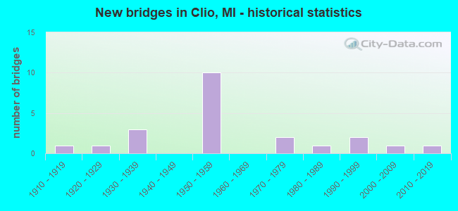
- New bridges - historical statistics
- 11910-1919
- 11920-1929
- 31930-1939
- 101950-1959
- 21970-1979
- 11980-1989
- 21990-1999
- 12000-2009
- 12010-2019

- Reconstructed bridges - Historical Statistics
- 11960-1969
- 01970-1979
- 01980-1989
- 41990-1999
- 02000-2009
- 12010-2019


- Bridge Condition - Deck
- 12.5%Very good
- 18.8%Good
- 37.5%Satisfactory
- 31.3%Fair

- Bridge Condition - Superstructure
- 31.3%Very good
- 12.5%Good
- 25.0%Satisfactory
- 25.0%Fair
- 6.3%Poor

- Bridge Condition - Substructure
- 31.3%Very good
- 31.3%Satisfactory
- 31.3%Fair
- 6.3%Serious

- Bridge Condition - Channel
- 7.7%Very good
- 46.2%Good
- 30.8%Satisfactory
- 7.7%Fair
- 7.7%Poor
Find on map >> Show street view
Structure Number: 262, Location: APPROX 1/4MI S OF 128TH A (Lat: 42.613753, Lng: -85.692292), Route carried "on" structure: County highway , Year Built: 1973, Status: Open, Structure Length: 0.69m (2.26ft), Average Daily Traffic: 70 (year 2002), Truck Traffic: 7%, Average Future Daily Traffic: 140 (year 2022), Design Load: H 20, Features Intersected: MILLER CREEK, Facility Carried by Structure: 15TH STREET
Minimum Vertical Clearance: 30.48m (100.00ft), Kilometerpoint: 0.534, Lanes on structure: 2, Owner: County Highway Agency, Approaching Roadway Width: 5.5m (18.0ft), Skew: 1 degrees, Material/Design: Steel, Design/Construction: Culvert, Number Of Spans In Main Unit: 2, Length of Maximum Span: 2.9m (9.5ft)
Condition: Channel: Satisfactory, Culverts: Satisfactory, Operating Rating: 21.7 metric tons, Method Used To Determine Operating Rating: Load Factor (LF) rating reported by rating factor (RF) method using MS18 loading, Inventory Rating: 13.0 metric tons, Method Used To Determine Inventory Rating: Load Factor (LF) rating reported by rating factor (RF) method using MS18 loading, Structural Evaluation: Meets minimum limits, Waterway Adequacy: Equal to present minimum criteria, Approach Roadway Alignment: Somewhat better than minimum adequacy, Designated Inspection Frequency: Every 24 months, Inspection Date: May 2021
Find on map >> Show street view
Structure Number: 2489, Location: 5.0 MI S OF SAGINAW COL (Lat: 43.151297, Lng: -83.763308), Route carried "on" structure: Interstate 75, Year Built: 1958, Year Reconstructed: 2002, Status: Open, Structure Length: 4.47m (14.67ft), Average Daily Traffic: 35,031 (year 2007), Truck Traffic: 12%, Average Future Daily Traffic: 38,951 (year 2018), Design Load: HS 20, Features Intersected: BRENT RUN CREEK
Minimum Vertical Clearance: 30.48m (100.00ft), Kilometerpoint: 37.023, Lanes on structure: 3, Base Highway Network: Yes (Inventory Route: 149, Subroute: 4), Owner: State Highway Agency, Approaching Roadway Width: 32.4m (106.3ft), Skew: 12 degrees, Material/Design: Prestressed concrete, Design/Construction: Stringer/Multi-beam, Number Of Spans In Main Unit: 3, Length of Maximum Span: 15.3m (50.2ft), Curb-To-Curb Width: 24.9m (81.7ft), Out-to-Out Width: 25.9m (85.0ft)
Condition: Deck: Good, Superstructure: Very good, Substructure: Satisfactory, Channel: Good, Operating Rating: 54.1 metric tons, Method Used To Determine Operating Rating: Load Factor (LF) rating reported by rating factor (RF) method using MS18 loading, Inventory Rating: 32.4 metric tons, Method Used To Determine Inventory Rating: Load Factor (LF) rating reported by rating factor (RF) method using MS18 loading, Structural Evaluation: Equal to present minimum criteria, Deck Geometry: Superior to present desirable criteria, Waterway Adequacy: Equal to present desirable criteria, Approach Roadway Alignment: Somewhat better than minimum adequacy, Designated Inspection Frequency: Every 24 months, Inspection Date: September 2020, Deck Structure Type: Concrete Cast-file-Place, Wearing Surface/Protective System: Wearing Surface: Monolithic Concrete, Deck Protection: Epoxy Coated Reinforcing
Find on map >> Show street view
Structure Number: 249, Location: 5.0 MI S OF SAGINAW COL (Lat: 43.151403, Lng: -83.763647), Route carried "on" structure: Interstate 75, Year Built: 1958, Year Reconstructed: 2001, Status: Open, Structure Length: 4.47m (14.67ft), Average Daily Traffic: 35,031 (year 2007), Truck Traffic: 12%, Average Future Daily Traffic: 38,951 (year 2018), Design Load: HS 20, Features Intersected: BRENT RUN CREEK
Minimum Vertical Clearance: 30.48m (100.00ft), Kilometerpoint: 36.833, Lanes on structure: 3, Base Highway Network: Yes (Inventory Route: 150, Subroute: 7), Owner: State Highway Agency, Approaching Roadway Width: 32.4m (106.3ft), Skew: 12 degrees, Material/Design: Prestressed concrete, Design/Construction: Stringer/Multi-beam, Number Of Spans In Main Unit: 3, Length of Maximum Span: 15.3m (50.2ft), Curb-To-Curb Width: 21.1m (69.2ft), Out-to-Out Width: 22.0m (72.2ft)
Condition: Deck: Satisfactory, Superstructure: Very good, Substructure: Satisfactory, Channel: Good, Operating Rating: 54.4 metric tons, Method Used To Determine Operating Rating: Load Factor (LF) rating reported by rating factor (RF) method using MS18 loading, Inventory Rating: 32.7 metric tons, Method Used To Determine Inventory Rating: Load Factor (LF) rating reported by rating factor (RF) method using MS18 loading, Structural Evaluation: Equal to present minimum criteria, Deck Geometry: Superior to present desirable criteria, Waterway Adequacy: Equal to present desirable criteria, Approach Roadway Alignment: Somewhat better than minimum adequacy, Designated Inspection Frequency: Every 24 months, Inspection Date: September 2020, Deck Structure Type: Concrete Cast-file-Place, Wearing Surface/Protective System: Wearing Surface: Monolithic Concrete, Deck Protection: Epoxy Coated Reinforcing
Find on map >> Show street view
Structure Number: 2492, Location: 0.4 MI N OF M-57 (Lat: 43.183175, Lng: -83.768658), Route carried "on" structure: Interstate 75, Year Built: 1958, Year Reconstructed: 2004, Status: Open, Structure Length: 4.11m (13.48ft), Average Daily Traffic: 28,043 (year 2007), Truck Traffic: 15%, Average Future Daily Traffic: 65,715 (year 2018), Design Load: HS 20, Features Intersected: PINE RUN CREEK
Minimum Vertical Clearance: 30.48m (100.00ft), Kilometerpoint: 40.412, Lanes on structure: 4, Base Highway Network: Yes (Inventory Route: 150, Subroute: 7), Owner: State Highway Agency, Approaching Roadway Width: 17.9m (58.7ft), Skew: 13 degrees, Material/Design: Concrete, Design/Construction: Tee Beam, Number Of Spans In Main Unit: 3, Length of Maximum Span: 13.7m (44.9ft), Curb-To-Curb Width: 24.1m (79.1ft), Out-to-Out Width: 24.6m (80.7ft)
Condition: Deck: Satisfactory, Superstructure: Fair, Substructure: Fair, Channel: Good, Operating Rating: 47.6 metric tons, Method Used To Determine Operating Rating: Load Factor (LF) rating reported by rating factor (RF) method using MS18 loading, Inventory Rating: 28.5 metric tons, Method Used To Determine Inventory Rating: Load Factor (LF) rating reported by rating factor (RF) method using MS18 loading, Structural Evaluation: Somewhat better than minimum adequacy, Deck Geometry: Superior to present desirable criteria, Waterway Adequacy: Equal to present desirable criteria, Approach Roadway Alignment: Equal to present minimum criteria, Designated Inspection Frequency: Every 24 months, Inspection Date: October 2020, Deck Structure Type: Concrete Cast-file-Place, Wearing Surface/Protective System: Wearing Surface: Latex Concrete
Find on map >> Show street view
Structure Number: 251, Location: 2.1 MI S OF M-57 (Lat: 43.148314, Lng: -83.763347), Route carried "on" structure: County highway 2584, Year Built: 1958, Status: Open, Structure Length: 7.56m (24.80ft), Average Daily Traffic: 2,145 (year 1996), Truck Traffic: 3%, Average Future Daily Traffic: 3,900 (year 2016), Design Load: H 15, Features Intersected: I-75, Facility Carried by Structure: DODGE RD
Minimum Vertical Clearance: 30.48m (100.00ft), Kilometerpoint: 7.991, Lanes on structure: 2, Lanes under structure: 6, Owner: State Highway Agency, Approaching Roadway Width: 12.2m (40.0ft), Material/Design: Steel, Design/Construction: Stringer/Multi-beam, Number Of Spans In Main Unit: 4, Length of Maximum Span: 21.2m (69.6ft), Curb-To-Curb Width: 9.1m (29.9ft), Out-to-Out Width: 10.1m (33.1ft)
Condition: Deck: Fair, Superstructure: Satisfactory, Substructure: Satisfactory, Operating Rating: 62.9 metric tons, Method Used To Determine Operating Rating: Load Factor (LF) rating reported by rating factor (RF) method using MS18 loading, Inventory Rating: 37.6 metric tons, Method Used To Determine Inventory Rating: Load Factor (LF) rating reported by rating factor (RF) method using MS18 loading, Structural Evaluation: Equal to present minimum criteria, Deck Geometry: Meets minimum limits, Underclear: High priority of corrective action, Approach Roadway Alignment: Somewhat better than minimum adequacy, Designated Inspection Frequency: Every 24 months, Inspection Date: June 2020, Deck Structure Type: Concrete Cast-file-Place, Wearing Surface/Protective System: Wearing Surface: Epoxy Overlay
Find on map >> Show street view
Structure Number: 2511, Location: 1.0 MI S OF M-57 (Lat: 43.162800, Lng: -83.768017), Route carried "on" structure: County highway , Year Built: 1958, Year Reconstructed: 2003, Status: Open, Structure Length: 6.68m (21.92ft), Average Daily Traffic: 2,400 (year 1996), Truck Traffic: 3%, Average Future Daily Traffic: 4,300 (year 2016), Design Load: H 15, Features Intersected: I-75, Facility Carried by Structure: WILSON RD
Minimum Vertical Clearance: 30.48m (100.00ft), Kilometerpoint: 7.757, Lanes on structure: 2, Lanes under structure: 6, Owner: State Highway Agency, Approaching Roadway Width: 8.5m (27.9ft), Skew: 1 degrees, Material/Design: Steel, Design/Construction: Stringer/Multi-beam, Number Of Spans In Main Unit: 4, Length of Maximum Span: 21.8m (71.5ft), Curb-To-Curb Width: 9.1m (29.9ft), Out-to-Out Width: 10.1m (33.1ft)
Condition: Deck: Fair, Superstructure: Good, Substructure: Very good, Operating Rating: 45.3 metric tons, Method Used To Determine Operating Rating: Load Factor (LF), Inventory Rating: 27.1 metric tons, Method Used To Determine Inventory Rating: Load Factor (LF), Structural Evaluation: Equal to present minimum criteria, Deck Geometry: Meets minimum limits, Underclear: Meets minimum limits, Approach Roadway Alignment: Equal to present minimum criteria, Designated Inspection Frequency: Every 24 months, Inspection Date: June 2020, Deck Structure Type: Concrete Cast-file-Place, Wearing Surface/Protective System: Wearing Surface: Epoxy Overlay
Find on map >> Show street view
Structure Number: 2512, Location: AT M-57 (Lat: 43.177592, Lng: -83.768614), Route carried "on" structure: State highway 57, Year Built: 1998, Status: Open, Structure Length: 7.84m (25.72ft), Average Daily Traffic: 20,432 (year 2007), Truck Traffic: 3%, Average Future Daily Traffic: 17,773 (year 2018), Design Load: HS 25 or greater, Features Intersected: I-75
Minimum Vertical Clearance: 30.48m (100.00ft), Kilometerpoint: 13.173, Lanes on structure: 5, Lanes under structure: 6, Owner: State Highway Agency, Approaching Roadway Width: 23.4m (76.8ft), Material/Design: Prestressed concrete, Design/Construction: Box Beam or Girders - Multiple, Number Of Spans In Main Unit: 4, Length of Maximum Span: 29.2m (95.8ft), Curb or Sidewalk Widths: Left: 2.4m (7.9ft), Right: 0.0m, Curb-To-Curb Width: 24.6m (80.7ft), Out-to-Out Width: 28.3m (92.8ft)
Condition: Deck: Good, Superstructure: Satisfactory, Substructure: Satisfactory, Operating Rating: 60.3 metric tons, Method Used To Determine Operating Rating: Load Factor (LF) rating reported by rating factor (RF) method using MS18 loading, Inventory Rating: 30.5 metric tons, Method Used To Determine Inventory Rating: Load Factor (LF) rating reported by rating factor (RF) method using MS18 loading, Structural Evaluation: Equal to present minimum criteria, Deck Geometry: Superior to present desirable criteria, Underclear: High priority of corrective action, Approach Roadway Alignment: Equal to present minimum criteria, Designated Inspection Frequency: Every 24 months, Inspection Date: June 2020, Deck Structure Type: Concrete Cast-file-Place, Wearing Surface/Protective System: Wearing Surface: Epoxy Overlay, Deck Protection: Epoxy Coated Reinforcing
Find on map >> Show street view
Structure Number: 2514, Location: 2.0 MI N OF M-57 (Lat: 43.206297, Lng: -83.768867), Route carried "on" structure: County highway , Year Built: 1959, Status: Open, Structure Length: 6.28m (20.60ft), Average Daily Traffic: 1,000 (year 1996), Truck Traffic: 2%, Average Future Daily Traffic: 1,800 (year 2016), Design Load: H 15, Features Intersected: I-75, Facility Carried by Structure: LAKE RD
Minimum Vertical Clearance: 30.48m (100.00ft), Kilometerpoint: 3.695, Lanes on structure: 2, Lanes under structure: 6, Owner: State Highway Agency, Approaching Roadway Width: 8.5m (27.9ft), Material/Design: Steel, Design/Construction: Stringer/Multi-beam, Number Of Spans In Main Unit: 4, Length of Maximum Span: 21.3m (69.9ft), Curb-To-Curb Width: 7.9m (25.9ft), Out-to-Out Width: 10.2m (33.5ft)
Condition: Deck: Satisfactory, Superstructure: Satisfactory, Substructure: Satisfactory, Operating Rating: 50.5 metric tons, Method Used To Determine Operating Rating: Load Factor (LF) rating reported by rating factor (RF) method using MS18 loading, Inventory Rating: 30.5 metric tons, Method Used To Determine Inventory Rating: Load Factor (LF) rating reported by rating factor (RF) method using MS18 loading, Structural Evaluation: Equal to present minimum criteria, Deck Geometry: Somewhat better than minimum adequacy, Underclear: High priority of corrective action, Approach Roadway Alignment: Equal to present minimum criteria, Designated Inspection Frequency: Every 24 months, Inspection Date: June 2020, Deck Structure Type: Concrete Cast-file-Place, Wearing Surface/Protective System: Wearing Surface: Epoxy Overlay
Find on map >> Show street view
Structure Number: 262, Location: IN CLIO (Lat: 43.177422, Lng: -83.732333), Route carried "on" structure: State highway 57, Year Built: 1915, Year Reconstructed: 1960, Status: Open, Structure Length: 0.91m (2.99ft), Average Daily Traffic: 14,723 (year 2007), Truck Traffic: 4%, Average Future Daily Traffic: 16,768 (year 2018), Design Load: H 15, Features Intersected: PINE RUN CREEK
Minimum Vertical Clearance: 30.48m (100.00ft), Kilometerpoint: 16.123, Lanes on structure: 2, Base Highway Network: Yes (Inventory Route: 149, Subroute: 3), Owner: State Highway Agency, Approaching Roadway Width: 14.0m (45.9ft), Material/Design: Concrete, Design/Construction: Arch - Deck, Number Of Spans In Main Unit: 1, Length of Maximum Span: 9.1m (29.9ft), Curb or Sidewalk Widths: Left: 1.5m (4.9ft), Right: 1.5m (4.9ft), Curb-To-Curb Width: 14.0m (45.9ft), Out-to-Out Width: 17.8m (58.4ft)
Condition: Deck: Fair, Superstructure: Fair, Substructure: Fair, Channel: Satisfactory, Operating Rating: 40.5 metric tons, Method Used To Determine Operating Rating: Field evaluation and documented engineering judgment, Inventory Rating: 24.3 metric tons, Method Used To Determine Inventory Rating: Field evaluation and documented engineering judgment, Structural Evaluation: Somewhat better than minimum adequacy, Deck Geometry: Superior to present desirable criteria, Waterway Adequacy: Equal to present desirable criteria, Approach Roadway Alignment: Equal to present desirable criteria, Length Of Structure Improvement: 0.91m (2.99ft), Designated Inspection Frequency: Every 24 months, Inspection Date: July 2020, Bridge Improvement Cost: $45,000, Roadway Improvement Cost: $3,000, Total Project Cost: $35,000, Deck Structure Type: Concrete Cast-file-Place, Wearing Surface/Protective System: Wearing Surface: Bituminous
Find on map >> Show street view
Structure Number: 2811, Location: 2250 FT EAST OF CLIO ROAD (Lat: 43.155669, Lng: -83.725617), Route carried "on" structure: ServiceCounty highway , Year Built: 1973, Status: Posted for load, Structure Length: 0.73m (2.40ft), Average Daily Traffic: 174 (year 2018), Truck Traffic: 2%, Average Future Daily Traffic: 314 (year 2038), Design Load: HS 20+Mod, Features Intersected: BENJAMIN RUN CREEK, Facility Carried by Structure: BINGHAM ROAD
Minimum Vertical Clearance: 30.48m (100.00ft), Kilometerpoint: 0.710, Lanes on structure: 2, Owner: County Highway Agency, Approaching Roadway Width: 9.1m (29.9ft), Material/Design: Wood or Timber, Design/Construction: Slab, Number Of Spans In Main Unit: 1, Length of Maximum Span: 6.7m (22.0ft), Curb-To-Curb Width: 10.1m (33.1ft), Out-to-Out Width: 11.0m (36.1ft)
Condition: Deck: Satisfactory, Superstructure: Satisfactory, Substructure: Fair, Channel: Fair, Operating Rating: 14.9 metric tons, Method Used To Determine Operating Rating: Allowable Stress (AS) rating reported by rating factor (RF) method using MS18 loading, Inventory Rating: 10.7 metric tons, Method Used To Determine Inventory Rating: Allowable Stress (AS) rating reported by rating factor (RF) method using MS18 loading, Structural Evaluation: High priority of corrective action, Deck Geometry: Better than present minimum criteria, Waterway Adequacy: Somewhat better than minimum adequacy, Approach Roadway Alignment: Better than present minimum criteria, Bridge Posting: Required (Relationship of Operating Rating to Maximum Legal Load: > 39.9% below), Designated Inspection Frequency: Every 24 months, Inspection Date: November 2020, Deck Structure Type: Wood or Timber, Wearing Surface/Protective System: Wearing Surface: Bituminous
Find on map >> Show street view
Structure Number: 2812, Location: 1350 FT EAST OF CLIO RD (Lat: 43.162836, Lng: -83.729367), Route carried "on" structure: Alternate County highway , Year Built: 2008, Status: Open, Structure Length: 1.58m (5.18ft), Average Daily Traffic: 3,762 (year 2018), Truck Traffic: 5%, Average Future Daily Traffic: 6,795 (year 2038), Design Load: HS 20, Features Intersected: BENJAMIN RUN, Facility Carried by Structure: WILSON ROAD
Minimum Vertical Clearance: 30.48m (100.00ft), Kilometerpoint: 10.902, Lanes on structure: 2, Owner: County Highway Agency, Approaching Roadway Width: 8.5m (27.9ft), Material/Design: Prestressed concrete, Design/Construction: Box Beam or Girders - Multiple, Number Of Spans In Main Unit: 1, Length of Maximum Span: 14.6m (47.9ft), Curb-To-Curb Width: 10.4m (34.1ft), Out-to-Out Width: 11.5m (37.7ft)
Condition: Deck: Very good, Superstructure: Very good, Substructure: Very good, Channel: Good, Operating Rating: 97.2 metric tons, Method Used To Determine Operating Rating: Load Factor (LF) rating reported by rating factor (RF) method using MS18 loading, Inventory Rating: 64.8 metric tons, Method Used To Determine Inventory Rating: Load Factor (LF) rating reported by rating factor (RF) method using MS18 loading, Structural Evaluation: Equal to present desirable criteria, Deck Geometry: Somewhat better than minimum adequacy, Waterway Adequacy: Better than present minimum criteria, Approach Roadway Alignment: Equal to present minimum criteria, Designated Inspection Frequency: Every 24 months, Inspection Date: November 2020, Deck Structure Type: Concrete Cast-file-Place, Wearing Surface/Protective System: Wearing Surface: Monolithic Concrete, Deck Protection: Epoxy Coated Reinforcing
Find on map >> Show street view
Structure Number: 2813, Location: 1750 FT WEST OF LINDEN RD (Lat: 43.191839, Lng: -83.780647), Route carried "on" structure: County highway , Year Built: 2016, Status: Open, Structure Length: 2.19m (7.19ft), Average Daily Traffic: 1,631 (year 2009), Truck Traffic: 2%, Average Future Daily Traffic: 2,946 (year 2029), Design Load: H 20, Features Intersected: PINE RUN, Facility Carried by Structure: FARRAND ROAD
Minimum Vertical Clearance: 30.48m (100.00ft), Kilometerpoint: 6.829, Lanes on structure: 2, Owner: County Highway Agency, Approaching Roadway Width: 11.0m (36.1ft), Skew: 2 degrees, Material/Design: Prestressed concrete, Design/Construction: Box Beam or Girders - Multiple, Number Of Spans In Main Unit: 1, Length of Maximum Span: 21.3m (69.9ft), Curb-To-Curb Width: 9.1m (29.9ft), Out-to-Out Width: 10.1m (33.1ft)
Condition: Deck: Very good, Superstructure: Very good, Substructure: Very good, Channel: Very good, Operating Rating: 54.8 metric tons, Method Used To Determine Operating Rating: Load and Resistance Factor Rating (LRFR) rating reported by rating factor(RF) method using HL-93 loadings, Inventory Rating: 37.9 metric tons, Method Used To Determine Inventory Rating: Load and Resistance Factor Rating (LRFR) rating reported by rating factor(RF) method using HL-93 loadings, Structural Evaluation: Equal to present desirable criteria, Deck Geometry: Somewhat better than minimum adequacy, Waterway Adequacy: Equal to present desirable criteria, Approach Roadway Alignment: Equal to present desirable criteria, Designated Inspection Frequency: Every 24 months, Inspection Date: November 2020, Deck Structure Type: Concrete Cast-file-Place, Wearing Surface/Protective System: Deck Protection: Epoxy Coated Reinforcing
Find on map >> Show street view
Structure Number: 2815, Location: INT OF WILSON & WEBSTER (Lat: 43.162792, Lng: -83.793536), Route carried "on" structure: County highway , Year Built: 1938, Year Reconstructed: 2015, Status: Open, Structure Length: 1.23m (4.04ft), Average Daily Traffic: 1,795 (year 2009), Truck Traffic: 3%, Average Future Daily Traffic: 3,242 (year 2029), Design Load: Greater than HL93, Features Intersected: BRENT RUN, Facility Carried by Structure: WILSON ROAD
Minimum Vertical Clearance: 30.48m (100.00ft), Kilometerpoint: 5.683, Lanes on structure: 2, Owner: County Highway Agency, Approaching Roadway Width: 11.0m (36.1ft), Skew: 2 degrees, Material/Design: Prestressed concrete, Design/Construction: Box Beam or Girders - Multiple, Number Of Spans In Main Unit: 1, Length of Maximum Span: 11.9m (39.0ft), Curb-To-Curb Width: 11.0m (36.1ft), Out-to-Out Width: 12.0m (39.4ft)
Condition: Deck: Good, Superstructure: Very good, Substructure: Very good, Channel: Good, Operating Rating: 76.8 metric tons, Method Used To Determine Operating Rating: Load and Resistance Factor Rating (LRFR) rating reported by rating factor(RF) method using HL-93 loadings, Inventory Rating: 59.3 metric tons, Method Used To Determine Inventory Rating: Load and Resistance Factor Rating (LRFR) rating reported by rating factor(RF) method using HL-93 loadings, Structural Evaluation: Equal to present desirable criteria, Deck Geometry: Equal to present minimum criteria, Waterway Adequacy: Better than present minimum criteria, Approach Roadway Alignment: Better than present minimum criteria, Designated Inspection Frequency: Every 24 months, Inspection Date: September 2021, Deck Structure Type: Concrete Cast-file-Place, Wearing Surface/Protective System: Deck Protection: Epoxy Coated Reinforcing
Find on map >> Show street view
Structure Number: 2817, Location: 2500 FT SOUTH OF WILSON (Lat: 43.155736, Lng: -83.773956), Route carried "on" structure: County highway , Year Built: 1931, Status: Open, Structure Length: 0.94m (3.08ft), Average Daily Traffic: 4,149 (year 2018), Truck Traffic: 5%, Average Future Daily Traffic: 7,493 (year 2038), Design Load: HS 20+Mod, Features Intersected: BRENT RUN, Facility Carried by Structure: LINDEN ROAD
Minimum Vertical Clearance: 30.48m (100.00ft), Kilometerpoint: 42.593, Lanes on structure: 2, Owner: County Highway Agency, Approaching Roadway Width: 9.1m (29.9ft), Material/Design: Concrete, Design/Construction: Tee Beam, Number Of Spans In Main Unit: 1, Length of Maximum Span: 8.8m (28.9ft), Curb-To-Curb Width: 9.1m (29.9ft), Out-to-Out Width: 9.8m (32.2ft)
Condition: Deck: Fair, Superstructure: Poor, Substructure: Serious, Channel: Poor, Operating Rating: 34.7 metric tons, Method Used To Determine Operating Rating: Load Factor (LF) rating reported by rating factor (RF) method using MS18 loading, Inventory Rating: 20.7 metric tons, Method Used To Determine Inventory Rating: Load Factor (LF) rating reported by rating factor (RF) method using MS18 loading, Structural Evaluation: High priority of corrective action, Deck Geometry: Meets minimum limits, Waterway Adequacy: Equal to present desirable criteria, Approach Roadway Alignment: Equal to present desirable criteria, Bridge Posting: Required (Relationship of Operating Rating to Maximum Legal Load: 30.0 - 39.9% below), Length Of Structure Improvement: 1.77m (5.81ft), Designated Inspection Frequency: Every 12 months, Inspection Date: November 2021, Bridge Improvement Cost: $136,000, Roadway Improvement Cost: $14,000, Total Project Cost: $170,000, Deck Structure Type: Concrete Cast-file-Place, Wearing Surface/Protective System: Wearing Surface: Bituminous
Find on map >> Show street view
Structure Number: 2818, Location: INTER OF LINDEN & FIELD (Lat: 43.184669, Lng: -83.774367), Route carried "on" structure: County highway , Year Built: 1929, Status: Posted for load, Structure Length: 1.00m (3.28ft), Average Daily Traffic: 5,320 (year 2017), Truck Traffic: 5%, Average Future Daily Traffic: 9,609 (year 2037), Design Load: HS 20+Mod, Features Intersected: PINE RUN, Facility Carried by Structure: LINDEN ROAD
Minimum Vertical Clearance: 30.48m (100.00ft), Kilometerpoint: 45.807, Lanes on structure: 2, Owner: County Highway Agency, Approaching Roadway Width: 10.1m (33.1ft), Material/Design: Concrete, Design/Construction: Tee Beam, Number Of Spans In Main Unit: 1, Length of Maximum Span: 9.1m (29.9ft), Curb-To-Curb Width: 9.1m (29.9ft), Out-to-Out Width: 9.8m (32.2ft)
Condition: Deck: Satisfactory, Superstructure: Fair, Substructure: Fair, Channel: Satisfactory, Operating Rating: 27.2 metric tons, Method Used To Determine Operating Rating: Load Factor (LF) rating reported by rating factor (RF) method using MS18 loading, Inventory Rating: 16.2 metric tons, Method Used To Determine Inventory Rating: Load Factor (LF) rating reported by rating factor (RF) method using MS18 loading, Structural Evaluation: Meets minimum limits, Deck Geometry: High priority of corrective action, Waterway Adequacy: Equal to present desirable criteria, Approach Roadway Alignment: Equal to present desirable criteria, Bridge Posting: Required (Relationship of Operating Rating to Maximum Legal Load: > 39.9% below), Designated Inspection Frequency: Every 12 months, Inspection Date: November 2021, Deck Structure Type: Concrete Cast-file-Place, Wearing Surface/Protective System: Wearing Surface: Bituminous
Find on map >> Show street view
Structure Number: 2819, Location: 1700 FT NORTH OF VIENNA (Lat: 43.182364, Lng: -83.754269), Route carried "on" structure: County highway , Year Built: 1937, Status: Open, Structure Length: 0.97m (3.18ft), Average Daily Traffic: 4,394 (year 2009), Truck Traffic: 5%, Average Future Daily Traffic: 7,936 (year 2029), Design Load: HS 20+Mod, Features Intersected: PINE RUN, Facility Carried by Structure: JENNINGS ROAD
Minimum Vertical Clearance: 30.48m (100.00ft), Kilometerpoint: 3.768, Lanes on structure: 2, Owner: County Highway Agency, Approaching Roadway Width: 6.1m (20.0ft), Skew: 3 degrees, Material/Design: Concrete, Design/Construction: Tee Beam, Number Of Spans In Main Unit: 1, Length of Maximum Span: 9.4m (30.8ft), Curb-To-Curb Width: 9.1m (29.9ft), Out-to-Out Width: 11.4m (37.4ft)
Condition: Deck: Fair, Superstructure: Fair, Substructure: Fair, Channel: Satisfactory, Operating Rating: 59.9 metric tons, Method Used To Determine Operating Rating: Load Factor (LF) rating reported by rating factor (RF) method using MS18 loading, Inventory Rating: 36.0 metric tons, Method Used To Determine Inventory Rating: Load Factor (LF) rating reported by rating factor (RF) method using MS18 loading, Structural Evaluation: Somewhat better than minimum adequacy, Deck Geometry: Meets minimum limits, Waterway Adequacy: Somewhat better than minimum adequacy, Approach Roadway Alignment: Equal to present desirable criteria, Designated Inspection Frequency: Every 24 months, Inspection Date: November 2020, Deck Structure Type: Concrete Cast-file-Place, Wearing Surface/Protective System: Wearing Surface: Bituminous
Find on map >> Show street view
Structure Number: 2821, Location: IN CLIO (Lat: 43.180022, Lng: -83.734614), Route carried "on" structure: City street 2002, Year Built: 1980, Status: Posted for load, Structure Length: 2.01m (6.59ft), Average Daily Traffic: 9,900 (year 1998), Truck Traffic: 2%, Average Future Daily Traffic: 12,870 (year 2018), Design Load: HS 20+Mod, Features Intersected: PINE RUN CREEK, Facility Carried by Structure: MILL STREET
Minimum Vertical Clearance: 30.48m (100.00ft), Kilometerpoint: 15.724, Lanes on structure: 3, Owner: City or Municipal Highway Agency, Approaching Roadway Width: 14.6m (47.9ft), Material/Design: Prestressed concrete, Design/Construction: Stringer/Multi-beam, Number Of Spans In Main Unit: 1, Length of Maximum Span: 18.2m (59.7ft), Curb or Sidewalk Widths: Left: 1.5m (4.9ft), Right: 1.5m (4.9ft), Curb-To-Curb Width: 14.6m (47.9ft), Out-to-Out Width: 18.2m (59.7ft)
Condition: Deck: Satisfactory, Superstructure: Good, Substructure: Very good, Channel: Good, Operating Rating: 39.9 metric tons, Method Used To Determine Operating Rating: Load Factor (LF) rating reported by rating factor (RF) method using MS18 loading, Inventory Rating: 24.0 metric tons, Method Used To Determine Inventory Rating: Load Factor (LF) rating reported by rating factor (RF) method using MS18 loading, Structural Evaluation: Somewhat better than minimum adequacy, Deck Geometry: Somewhat better than minimum adequacy, Waterway Adequacy: Superior to present desirable criteria, Approach Roadway Alignment: Equal to present desirable criteria, Bridge Posting: Required (Relationship of Operating Rating to Maximum Legal Load: 20.0 - 29.9% below), Designated Inspection Frequency: Every 24 months, Inspection Date: September 2020, Deck Structure Type: Concrete Cast-file-Place, Wearing Surface/Protective System: Wearing Surface: Monolithic Concrete, Deck Protection: Epoxy Coated Reinforcing
Find on map >> Show street view
Structure Number: 251, Location: 2.1 MI S OF M-57 (Lat: 43.148314, Lng: -83.763347), Route carried "under" structure: Interstate 75, Year Built: 1958, Structure Length: 0. m, Average Daily Traffic: 70,062 (year 2007), Truck Traffic: 12%, Features Intersected: I-75, Facility Carried by Structure: DODGE RD
Minimum Vertical Clearance: 5.23m (17.16ft), Kilometerpoint: 36.691, Lanes on structure: 2, Lanes under structure: 6, Material/Design: Steel, Design/Construction: Stringer/Multi-beam, Length of Maximum Span: 21.2m (69.6ft)
Find on map >> Show street view
Structure Number: 2511, Location: 1.0 MI S OF M-57 (Lat: 43.162800, Lng: -83.768017), Route carried "under" structure: Interstate 75, Year Built: 1958, Structure Length: 0. m, Average Daily Traffic: 70,062 (year 2007), Truck Traffic: 12%, Features Intersected: I-75, Facility Carried by Structure: WILSON RD
Minimum Vertical Clearance: 5.61m (18.41ft), Kilometerpoint: 38.362, Lanes on structure: 2, Lanes under structure: 6, Material/Design: Steel, Design/Construction: Stringer/Multi-beam, Length of Maximum Span: 21.8m (71.5ft)
Find on map >> Show street view
Structure Number: 2512, Location: AT M-57 (Lat: 43.177592, Lng: -83.768614), Route carried "under" structure: Interstate 75, Year Built: 1998, Structure Length: 0. m, Average Daily Traffic: 70,062 (year 2007), Truck Traffic: 15%, Features Intersected: I-75, Facility Carried by Structure: M-57 (VIENNA RD)
Minimum Vertical Clearance: 5.03m (16.50ft), Kilometerpoint: 40.008, Lanes on structure: 5, Lanes under structure: 6, Material/Design: Prestressed concrete, Design/Construction: Box Beam or Girders - Multiple, Length of Maximum Span: 29.2m (95.8ft)
Find on map >> Show street view
Structure Number: 2513, Location: 1.0 MI N OF M-57 (Lat: 43.191797, Lng: -83.768775), Route carried "under" structure: Interstate 75, Year Built: 1958, Structure Length: 0. m, Average Daily Traffic: 56,086 (year 2007), Truck Traffic: 15%, Features Intersected: I-75, Facility Carried by Structure: FARRAND RD
Minimum Vertical Clearance: 5.11m (16.77ft), Kilometerpoint: 41.585, Lanes on structure: 2, Lanes under structure: 4, Material/Design: Steel, Design/Construction: Stringer/Multi-beam, Length of Maximum Span: 21.3m (69.9ft)
Find on map >> Show street view
Structure Number: 2514, Location: 2.0 MI N OF M-57 (Lat: 43.206297, Lng: -83.768867), Route carried "under" structure: Interstate 75, Year Built: 1959, Structure Length: 0. m, Average Daily Traffic: 56,086 (year 2007), Truck Traffic: 15%, Features Intersected: I-75, Facility Carried by Structure: LAKE RD
Minimum Vertical Clearance: 4.57m (14.99ft), Kilometerpoint: 43.195, Lanes on structure: 2, Lanes under structure: 6, Material/Design: Steel, Design/Construction: Stringer/Multi-beam, Length of Maximum Span: 21.3m (69.9ft)