Bridge Statistics for Clive, Iowa (IA)
Condition, Traffic, Stress, Structural Evaluation, Project Costs
- National Bridge Inventory (NBI) Statistics
- 14Number of bridges
- 256ft / 78.0mTotal length
- 228,899Total average daily traffic
- 20,516Total average daily truck traffic
- National Bridge Inventory (NBI) Registered Bridges for Clive
- No street view available for this location
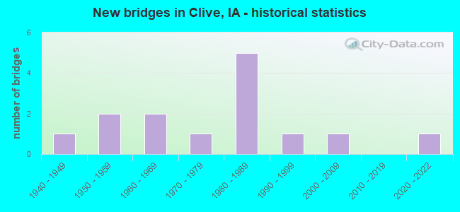
- New bridges - historical statistics
- 11940-1949
- 21950-1959
- 21960-1969
- 11970-1979
- 51980-1989
- 11990-1999
- 12000-2009
- 12020-2022
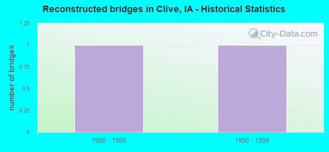
- Reconstructed bridges - Historical Statistics
- 11980-1989
- 11990-1999
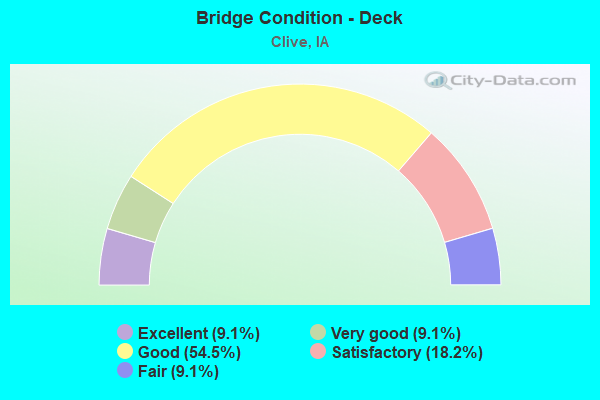
- Bridge Condition - Deck
- 9.1%Excellent
- 9.1%Very good
- 54.5%Good
- 18.2%Satisfactory
- 9.1%Fair
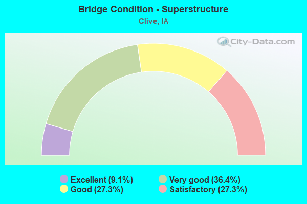
- Bridge Condition - Superstructure
- 9.1%Excellent
- 36.4%Very good
- 27.3%Good
- 27.3%Satisfactory
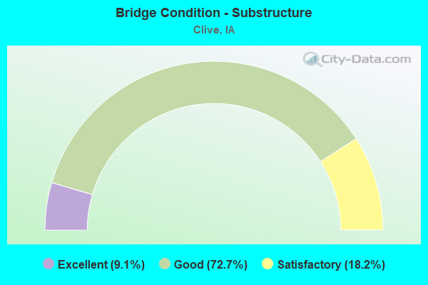
- Bridge Condition - Substructure
- 9.1%Excellent
- 72.7%Good
- 18.2%Satisfactory
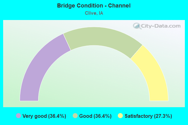
- Bridge Condition - Channel
- 36.4%Very good
- 36.4%Good
- 27.3%Satisfactory
Find on map >> Show street view
Structure Number: 2401, Location: 079253300 (Lat: 41.610061, Lng: -93.774956), Route carried "on" structure: City street , Year Built: 1988, Status: Open, Structure Length: 10.11m (33.17ft), Average Daily Traffic: 6,100 (year 2012), Average Future Daily Traffic: 6,100 (year 2041), Design Load: H 20, Features Intersected: WALNUT CREEK, Facility Carried by Structure: NW 114TH ST
Minimum Vertical Clearance: 30+ m (98+ ft), Kilometerpoint: 1.194, Lanes on structure: 2, Owner: City or Municipal Highway Agency, Approaching Roadway Width: 9.1m (29.9ft), Skew: 4 degrees, Material/Design: Prestressed concrete, Design/Construction: Stringer/Multi-beam, Number Of Spans In Main Unit: 4, Length of Maximum Span: 24.8m (81.4ft), Curb or Sidewalk Widths: Left: 1.2m (3.9ft), Right: 0.0m, Curb-To-Curb Width: 9.1m (29.9ft), Out-to-Out Width: 11.6m (38.1ft)
Condition: Deck: Fair, Superstructure: Satisfactory, Substructure: Good, Channel: Good, Operating Rating: 59.5 metric tons, Method Used To Determine Operating Rating: Load Factor (LF), Inventory Rating: 35.6 metric tons, Method Used To Determine Inventory Rating: Load Factor (LF), Structural Evaluation: Equal to present minimum criteria, Deck Geometry: Meets minimum limits, Waterway Adequacy: Equal to present desirable criteria, Approach Roadway Alignment: Equal to present minimum criteria, Designated Inspection Frequency: Every 24 months, Inspection Date: May 2021, Deck Structure Type: Concrete Cast-file-Place, Wearing Surface/Protective System: Wearing Surface: Monolithic Concrete
Find on map >> Show street view
Structure Number: 2411, Location: 079253502 (Lat: 41.602017, Lng: -93.736186), Route carried "on" structure: City street , Year Built: 1970, Status: Open, Structure Length: 5.07m (16.63ft), Average Daily Traffic: 26,100 (year 2016), Average Future Daily Traffic: 26,100 (year 2041), Design Load: HS 20, Features Intersected: WALNUT CREEK, Facility Carried by Structure: NW 86TH ST
Minimum Vertical Clearance: 30+ m (98+ ft), Kilometerpoint: 0.175, Lanes on structure: 4, Base Highway Network: Yes, Owner: City or Municipal Highway Agency, Approaching Roadway Width: 14.6m (47.9ft), Material/Design: Prestressed concrete, Design/Construction: Stringer/Multi-beam, Number Of Spans In Main Unit: 3, Length of Maximum Span: 21.0m (68.9ft), Curb or Sidewalk Widths: Left: 1.5m (4.9ft), Right: 0.0m, Curb-To-Curb Width: 14.6m (47.9ft), Out-to-Out Width: 17.4m (57.1ft)
Condition: Deck: Satisfactory, Superstructure: Satisfactory, Substructure: Good, Channel: Satisfactory, Operating Rating: 51.1 metric tons, Method Used To Determine Operating Rating: Load Factor (LF), Inventory Rating: 30.6 metric tons, Method Used To Determine Inventory Rating: Load Factor (LF), Structural Evaluation: Equal to present minimum criteria, Deck Geometry: High priority of replacement, Waterway Adequacy: Equal to present minimum criteria, Approach Roadway Alignment: Equal to present minimum criteria, Length Of Structure Improvement: 19.90m (65.29ft), Designated Inspection Frequency: Every 24 months, Inspection Date: May 2021, Bridge Improvement Cost: $568,000, Roadway Improvement Cost: $60,000, Deck Structure Type: Concrete Cast-file-Place, Wearing Surface/Protective System: Wearing Surface: Monolithic Concrete
Find on map >> Show street view
Structure Number: 12491, Location: At jct. I-35/80 (Lat: 41.600447, Lng: -93.777314), Route carried "on" structure: City street , Year Built: 1984, Year Reconstructed: 2004, Status: Open, Structure Length: 7.16m (23.49ft), Average Daily Traffic: 30,700 (year 2016), Average Future Daily Traffic: 30,700 (year 2040), Design Load: HS 20, Features Intersected: I-35 & I-80, Facility Carried by Structure: W UNIVERSITY
Minimum Vertical Clearance: 30+ m (98+ ft), Kilometerpoint: 5.245, Lanes on structure: 5, Lanes under structure: 8, Owner: State Highway Agency, Approaching Roadway Width: 24.1m (79.1ft), Material/Design: Steel continuous, Design/Construction: Stringer/Multi-beam, Number Of Spans In Main Unit: 2, Length of Maximum Span: 35.7m (117.1ft), Curb-To-Curb Width: 23.8m (78.1ft), Out-to-Out Width: 27.7m (90.9ft)
Condition: Deck: Good, Superstructure: Good, Substructure: Good, Operating Rating: 78.3 metric tons, Method Used To Determine Operating Rating: Load Factor (LF), Inventory Rating: 47.0 metric tons, Method Used To Determine Inventory Rating: Load Factor (LF), Structural Evaluation: Better than present minimum criteria, Deck Geometry: Better than present minimum criteria, Underclear: Equal to present minimum criteria, Approach Roadway Alignment: Equal to present desirable criteria, Designated Inspection Frequency: Every 24 months, Inspection Date: March 2020, Deck Structure Type: Concrete Cast-file-Place, Wearing Surface/Protective System: Wearing Surface: Monolithic Concrete, Deck Protection: Epoxy Coated Reinforcing
Find on map >> Show street view
Structure Number: 1952, Location: 0.6 mi. N of jct. SR L51 (Lat: 42.633808, Lng: -95.631225), Route carried "on" structure: State highway 31, Year Built: 1949, Status: Open, Structure Length: 0.91m (2.99ft), Average Daily Traffic: 1,070 (year 2020), Truck Traffic: 23%, Average Future Daily Traffic: 1,070 (year 2040), Design Load: H 20, Features Intersected: STREAM
Minimum Vertical Clearance: 30+ m (98+ ft), Kilometerpoint: 55.725, Lanes on structure: 2, Base Highway Network: Yes, Owner: State Highway Agency, Approaching Roadway Width: 11.0m (36.1ft), Skew: 4 degrees, Material/Design: Concrete continuous, Design/Construction: Culvert, Number Of Spans In Main Unit: 2, Length of Maximum Span: 4.3m (14.1ft)
Condition: Channel: Satisfactory, Culverts: Satisfactory, Operating Rating: 24.5 metric tons, Method Used To Determine Operating Rating: Field evaluation and documented engineering judgment, Inventory Rating: 18.1 metric tons, Method Used To Determine Inventory Rating: Field evaluation and documented engineering judgment, Structural Evaluation: Somewhat better than minimum adequacy, Waterway Adequacy: Equal to present desirable criteria, Approach Roadway Alignment: Better than present minimum criteria, Designated Inspection Frequency: Every 24 months, Inspection Date: November 2020
Find on map >> Show street view
Structure Number: 4039, Location: 1.1 MI W OF W JCT IA 28 (Lat: 41.614725, Lng: -93.726697), Route carried "on" structure: US 6, Year Built: 1969, Status: Open, Structure Length: 3.14m (10.30ft), Average Daily Traffic: 18,000 (year 2020), Truck Traffic: 2%, Average Future Daily Traffic: 18,000 (year 2040), Design Load: HS 20, Features Intersected: N. WALNUT CREEK&BIKE PAT
Minimum Vertical Clearance: 30+ m (98+ ft), Kilometerpoint: 218.494, Lanes on structure: 4, Base Highway Network: Yes, Owner: State Highway Agency, Approaching Roadway Width: 14.6m (47.9ft), Skew: 20 degrees, Material/Design: Concrete continuous, Design/Construction: Slab, Number Of Spans In Main Unit: 3, Length of Maximum Span: 11.9m (39.0ft), Curb-To-Curb Width: 17.1m (56.1ft), Out-to-Out Width: 24.2m (79.4ft)
Condition: Deck: Good, Superstructure: Good, Substructure: Satisfactory, Channel: Good, Operating Rating: 85.2 metric tons, Method Used To Determine Operating Rating: Load Factor (LF), Inventory Rating: 51.1 metric tons, Method Used To Determine Inventory Rating: Load Factor (LF), Structural Evaluation: Equal to present minimum criteria, Deck Geometry: Somewhat better than minimum adequacy, Waterway Adequacy: Equal to present minimum criteria, Approach Roadway Alignment: Equal to present desirable criteria, Designated Inspection Frequency: Every 24 months, Inspection Date: March 2020, Deck Structure Type: Concrete Cast-file-Place, Wearing Surface/Protective System: Wearing Surface: Low Slump Concrete
Find on map >> Show street view
Structure Number: 4128, Location: 0.3 MI. W OF JCT. 6 (Lat: 41.610700, Lng: -93.776689), Route carried "on" structure: Interstate 80, Year Built: 1958, Year Reconstructed: 1988, Status: Open, Structure Length: 12.62m (41.40ft), Average Daily Traffic: 46,350 (year 2020), Truck Traffic: 17%, Average Future Daily Traffic: 46,350 (year 2041), Design Load: HS 20, Features Intersected: WALNUT CREEK
Minimum Vertical Clearance: 30+ m (98+ ft), Kilometerpoint: 200.357, Lanes on structure: 4, Base Highway Network: Yes, Owner: State Highway Agency, Approaching Roadway Width: 22.9m (75.1ft), Material/Design: Steel continuous, Design/Construction: Stringer/Multi-beam, Number Of Spans In Main Unit: 6, Length of Maximum Span: 22.6m (74.1ft), Curb-To-Curb Width: 22.7m (74.5ft), Out-to-Out Width: 23.6m (77.4ft)
Condition: Deck: Good, Superstructure: Satisfactory, Substructure: Satisfactory, Channel: Good, Operating Rating: 57.0 metric tons, Method Used To Determine Operating Rating: Load Factor (LF), Inventory Rating: 34.2 metric tons, Method Used To Determine Inventory Rating: Load Factor (LF), Structural Evaluation: Equal to present minimum criteria, Deck Geometry: Superior to present desirable criteria, Waterway Adequacy: Equal to present minimum criteria, Approach Roadway Alignment: Equal to present desirable criteria, Designated Inspection Frequency: Every 24 months, Inspection Date: October 2021, Deck Structure Type: Concrete Cast-file-Place, Wearing Surface/Protective System: Wearing Surface: Low Slump Concrete
Find on map >> Show street view
Structure Number: 4666, Location: 0.7 mi. S of N jct IA 471 (Lat: 42.311592, Lng: -95.130933), Route carried "on" structure: State highway 175, Year Built: 1967, Status: Open, Structure Length: 5.18m (16.99ft), Average Daily Traffic: 1,740 (year 2020), Truck Traffic: 15%, Average Future Daily Traffic: 1,740 (year 2041), Design Load: HS 20, Features Intersected: BOYER RIVER
Minimum Vertical Clearance: 30+ m (98+ ft), Kilometerpoint: 113.188, Lanes on structure: 2, Base Highway Network: Yes, Owner: State Highway Agency, Approaching Roadway Width: 7.3m (24.0ft), Material/Design: Prestressed concrete, Design/Construction: Stringer/Multi-beam, Number Of Spans In Main Unit: 3, Length of Maximum Span: 17.4m (57.1ft), Curb-To-Curb Width: 9.1m (29.9ft), Out-to-Out Width: 10.8m (35.4ft)
Condition: Deck: Satisfactory, Superstructure: Very good, Substructure: Good, Channel: Satisfactory, Operating Rating: 66.0 metric tons, Method Used To Determine Operating Rating: Load Factor (LF), Inventory Rating: 25.5 metric tons, Method Used To Determine Inventory Rating: Load Factor (LF), Structural Evaluation: Equal to present minimum criteria, Deck Geometry: Somewhat better than minimum adequacy, Waterway Adequacy: Equal to present minimum criteria, Approach Roadway Alignment: Equal to present desirable criteria, Designated Inspection Frequency: Every 24 months, Inspection Date: October 2021, Deck Structure Type: Concrete Cast-file-Place, Wearing Surface/Protective System: Wearing Surface: Low Slump Concrete
Find on map >> Show street view
Structure Number: 50406, Location: 079253400 (Lat: 41.609428, Lng: -93.755542), Route carried "on" structure: City street , Year Built: 1988, Status: Open, Structure Length: 7.65m (25.10ft), Average Daily Traffic: 3,800 (year 2016), Average Future Daily Traffic: 3,800 (year 2041), Design Load: HS 20, Features Intersected: WALNUT CREEK, Facility Carried by Structure: NB NW 100TH ST
Minimum Vertical Clearance: 30+ m (98+ ft), Kilometerpoint: 1.122, Lanes on structure: 2, Owner: City or Municipal Highway Agency, Approaching Roadway Width: 19.8m (65.0ft), Skew: 10 degrees, Material/Design: Prestressed concrete, Design/Construction: Stringer/Multi-beam, Number Of Spans In Main Unit: 3, Length of Maximum Span: 26.4m (86.6ft), Curb-To-Curb Width: 7.3m (24.0ft), Out-to-Out Width: 8.3m (27.2ft)
Condition: Deck: Good, Superstructure: Very good, Substructure: Good, Channel: Good, Operating Rating: 64.6 metric tons, Method Used To Determine Operating Rating: Load Factor (LF), Inventory Rating: 38.7 metric tons, Method Used To Determine Inventory Rating: Load Factor (LF), Structural Evaluation: Better than present minimum criteria, Deck Geometry: High priority of replacement, Waterway Adequacy: Equal to present desirable criteria, Approach Roadway Alignment: Better than present minimum criteria, Designated Inspection Frequency: Every 24 months, Inspection Date: May 2021, Deck Structure Type: Concrete Cast-file-Place, Wearing Surface/Protective System: Wearing Surface: Monolithic Concrete
Find on map >> Show street view
Structure Number: 50411, Location: 079253400 (Lat: 41.610108, Lng: -93.755703), Route carried "on" structure: City street , Year Built: 1988, Status: Open, Structure Length: 7.65m (25.10ft), Average Daily Traffic: 3,400 (year 2016), Average Future Daily Traffic: 3,400 (year 2041), Design Load: HS 20, Features Intersected: WALNUT CREEK, Facility Carried by Structure: SB NW 100TH ST
Minimum Vertical Clearance: 30+ m (98+ ft), Kilometerpoint: 0.526, Lanes on structure: 2, Owner: City or Municipal Highway Agency, Approaching Roadway Width: 19.8m (65.0ft), Skew: 10 degrees, Material/Design: Prestressed concrete, Design/Construction: Stringer/Multi-beam, Number Of Spans In Main Unit: 3, Length of Maximum Span: 26.4m (86.6ft), Curb or Sidewalk Widths: Left: 1.5m (4.9ft), Right: 0.0m, Curb-To-Curb Width: 7.3m (24.0ft), Out-to-Out Width: 10.1m (33.1ft)
Condition: Deck: Good, Superstructure: Very good, Substructure: Good, Channel: Very good, Operating Rating: 64.6 metric tons, Method Used To Determine Operating Rating: Load Factor (LF), Inventory Rating: 38.7 metric tons, Method Used To Determine Inventory Rating: Load Factor (LF), Structural Evaluation: Better than present minimum criteria, Deck Geometry: High priority of replacement, Waterway Adequacy: Equal to present desirable criteria, Approach Roadway Alignment: Better than present minimum criteria, Designated Inspection Frequency: Every 24 months, Inspection Date: May 2021, Deck Structure Type: Concrete Cast-file-Place, Wearing Surface/Protective System: Wearing Surface: Monolithic Concrete
Find on map >> Show street view
Structure Number: 504415, Location: 079253200 (Lat: 41.613247, Lng: -93.792558), Route carried "on" structure: City street , Year Built: 1998, Status: Open, Structure Length: 7.54m (24.74ft), Average Daily Traffic: 7,500 (year 2016), Average Future Daily Traffic: 7,500 (year 2041), Design Load: HS 20, Features Intersected: WALNUT CREEK, Facility Carried by Structure: NW 128TH ST SB
Minimum Vertical Clearance: 30+ m (98+ ft), Kilometerpoint: 0.206, Lanes on structure: 2, Owner: City or Municipal Highway Agency, Approaching Roadway Width: 10.4m (34.1ft), Material/Design: Prestressed concrete, Design/Construction: Stringer/Multi-beam, Number Of Spans In Main Unit: 3, Length of Maximum Span: 25.0m (82.0ft), Curb or Sidewalk Widths: Left: 1.5m (4.9ft), Right: 0.0m, Curb-To-Curb Width: 9.6m (31.5ft), Out-to-Out Width: 12.3m (40.4ft)
Condition: Deck: Good, Superstructure: Good, Substructure: Good, Channel: Very good, Operating Rating: 67.7 metric tons, Method Used To Determine Operating Rating: Load Factor (LF), Inventory Rating: 40.5 metric tons, Method Used To Determine Inventory Rating: Load Factor (LF), Structural Evaluation: Better than present minimum criteria, Deck Geometry: Meets minimum limits, Waterway Adequacy: Better than present minimum criteria, Approach Roadway Alignment: Equal to present minimum criteria, Designated Inspection Frequency: Every 24 months, Inspection Date: May 2021, Deck Structure Type: Concrete Cast-file-Place, Wearing Surface/Protective System: Wearing Surface: Integral Concrete
Find on map >> Show street view
Structure Number: 50485, Location: 079253200 (Lat: 41.612633, Lng: -93.792956), Route carried "on" structure: City street , Year Built: 2007, Status: Open, Structure Length: 7.54m (24.74ft), Average Daily Traffic: 7,300 (year 2016), Average Future Daily Traffic: 7,300 (year 2041), Design Load: HS 20, Features Intersected: WALNUT CREEK, Facility Carried by Structure: NW 128TH ST NB
Minimum Vertical Clearance: 30+ m (98+ ft), Kilometerpoint: 1.381, Lanes on structure: 2, Owner: City or Municipal Highway Agency, Approaching Roadway Width: 15.2m (49.9ft), Material/Design: Prestressed concrete, Design/Construction: Stringer/Multi-beam, Number Of Spans In Main Unit: 3, Length of Maximum Span: 25.0m (82.0ft), Curb or Sidewalk Widths: Left: 0.0m, Right: 1.5m (4.9ft), Curb-To-Curb Width: 9.8m (32.2ft), Out-to-Out Width: 12.5m (41.0ft)
Condition: Deck: Very good, Superstructure: Very good, Substructure: Good, Channel: Very good, Operating Rating: 67.7 metric tons, Method Used To Determine Operating Rating: Load Factor (LF), Inventory Rating: 40.5 metric tons, Method Used To Determine Inventory Rating: Load Factor (LF), Structural Evaluation: Better than present minimum criteria, Deck Geometry: Meets minimum limits, Waterway Adequacy: Better than present minimum criteria, Approach Roadway Alignment: Equal to present minimum criteria, Designated Inspection Frequency: Every 24 months, Inspection Date: May 2021, Deck Structure Type: Concrete Cast-file-Place, Wearing Surface/Protective System: Wearing Surface: Monolithic Concrete
Find on map >> Show street view
Structure Number: 505665, Location: 079262200 (Lat: 41.634094, Lng: -93.862311), Route carried "on" structure: City street , Year Built: 2020, Status: Open, Structure Length: 3.38m (11.09ft), Average Daily Traffic: 289 (year 2021), Average Future Daily Traffic: 289 (year 2041), Design Load: HL 93, Features Intersected: LITTLE WALNUT CREEK, Facility Carried by Structure: WESTGATE PARKWAY
Minimum Vertical Clearance: 30+ m (98+ ft), Kilometerpoint: 0.550, Lanes on structure: 2, Owner: City or Municipal Highway Agency, Approaching Roadway Width: 7.9m (25.9ft), Skew: 1 degrees, Material/Design: Concrete continuous, Design/Construction: Slab, Number Of Spans In Main Unit: 3, Length of Maximum Span: 13.1m (43.0ft), Curb or Sidewalk Widths: Left: 2.4m (7.9ft), Right: 1.5m (4.9ft), Curb-To-Curb Width: 9.1m (29.9ft), Out-to-Out Width: 14.6m (47.9ft)
Condition: Deck: Excellent, Superstructure: Excellent, Substructure: Excellent, Channel: Very good, Operating Rating: 42.1 metric tons, Method Used To Determine Operating Rating: Assigned ratings based on Load and Resistance Factor Design (LRFD) reported by rating factor (RF) using HL93 loadings, Inventory Rating: 32.4 metric tons, Method Used To Determine Inventory Rating: Assigned ratings based on Load and Resistance Factor Design (LRFD) reported by rating factor (RF) using HL93 loadings, Structural Evaluation: Equal to present desirable criteria, Deck Geometry: Equal to present minimum criteria, Waterway Adequacy: Equal to present desirable criteria, Approach Roadway Alignment: Equal to present desirable criteria, Designated Inspection Frequency: Every 24 months, Inspection Date: May 2021, Deck Structure Type: Concrete Cast-file-Place, Wearing Surface/Protective System: Wearing Surface: Monolithic Concrete, Deck Protection: Epoxy Coated Reinforcing
Find on map >> Show street view
Structure Number: 12491, Location: At jct. I-35/80 (Lat: 41.600447, Lng: -93.777314), Route carried "under" structure: Interstate 35, Year Built: 1984, Structure Length: 0. m, Average Daily Traffic: 62,200 (year 2020), Truck Traffic: 18%, Features Intersected: I-35 & I-80, Facility Carried by Structure: W UNIVERSITY
Minimum Vertical Clearance: 30+ m (98+ ft), Kilometerpoint: 117.881, Lanes on structure: 5, Lanes under structure: 8, Material/Design: Steel continuous, Design/Construction: Stringer/Multi-beam, Length of Maximum Span: 35.7m (117.1ft)
Find on map >> Show street view
Structure Number: 413, Location: AT JUNCTION WITH US 6 (Lat: 41.614653, Lng: -93.776697), Route carried "under" structure: US 6, Year Built: 1958, Structure Length: 0. m, Average Daily Traffic: 14,350 (year 2020), Truck Traffic: 4%, Features Intersected: US 6, Facility Carried by Structure: I 35 NB I 80 EB
Minimum Vertical Clearance: 30+ m (98+ ft), Kilometerpoint: 214.318, Lanes on structure: 3, Lanes under structure: 6, Material/Design: Steel continuous, Design/Construction: Stringer/Multi-beam, Length of Maximum Span: 14.6m (47.9ft)