Bridge Statistics for Coal Grove, Ohio (OH)
Condition, Traffic, Stress, Structural Evaluation, Project Costs
- National Bridge Inventory (NBI) Statistics
- 22Number of bridges
- 561ft / 171mTotal length
- $166,000Total costs
- 191,675Total average daily traffic
- 13,797Total average daily truck traffic
- National Bridge Inventory (NBI) Registered Bridges for Coal Grove
- No street view available for this location
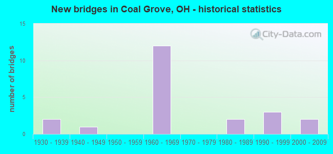
- New bridges - historical statistics
- 21930-1939
- 11940-1949
- 121960-1969
- 21980-1989
- 31990-1999
- 22000-2009

- Reconstructed bridges - Historical Statistics
- 11980-1989
- 01990-1999
- 12000-2009


- Bridge Condition - Deck
- 7.1%Very good
- 28.6%Good
- 50.0%Satisfactory
- 7.1%Fair
- 7.1%Poor

- Bridge Condition - Superstructure
- 7.1%Very good
- 14.3%Good
- 42.9%Satisfactory
- 28.6%Fair
- 7.1%Poor

- Bridge Condition - Substructure
- 42.9%Good
- 35.7%Satisfactory
- 7.1%Fair
- 14.3%Poor

- Bridge Condition - Channel
- 12.5%Very good
- 12.5%Good
- 37.5%Satisfactory
- 25.0%Fair
- 12.5%Poor
Find on map >> Show street view
Structure Number: 4400755, Location: 0.5 MI W OF SR 243 (Lat: 38.509269, Lng: -82.653169), Route carried "on" structure: City street WDLND, Year Built: 1962, Status: Posted for load, Structure Length: 6.49m (21.29ft), Average Daily Traffic: 100 (year 1990), Average Future Daily Traffic: 29,946 (year 2010), Design Load: HS 20, Features Intersected: US 52 EB & WB, Facility Carried by Structure: WOODLAND CEM ROAD
Minimum Vertical Clearance: 30+ m (98+ ft), Kilometerpoint: 0.000, Lanes on structure: 2, Lanes under structure: 4, Owner: State Highway Agency, Approaching Roadway Width: 7.9m (25.9ft), Skew: 1 degrees, Material/Design: Steel continuous, Design/Construction: Stringer/Multi-beam, Number Of Spans In Main Unit: 4, Length of Maximum Span: 17.4m (57.1ft), Curb or Sidewalk Widths: Left: 0.7m (2.3ft), Right: 1.5m (4.9ft), Curb-To-Curb Width: 7.3m (24.0ft), Out-to-Out Width: 10.2m (33.5ft)
Condition: Deck: Satisfactory, Superstructure: Fair, Substructure: Satisfactory, Operating Rating: 35.6 metric tons, Method Used To Determine Operating Rating: Load Factor (LF) rating reported by rating factor (RF) method using MS18 loading, Inventory Rating: 19.4 metric tons, Method Used To Determine Inventory Rating: Load Factor (LF) rating reported by rating factor (RF) method using MS18 loading, Structural Evaluation: Somewhat better than minimum adequacy, Deck Geometry: Equal to present minimum criteria, Underclear: High priority of corrective action, Approach Roadway Alignment: Equal to present desirable criteria, Bridge Posting: Required (Relationship of Operating Rating to Maximum Legal Load: 20.0 - 29.9% below), Designated Inspection Frequency: Every 12 months, Inspection Date: November 2021, Deck Structure Type: Concrete Cast-file-Place, Wearing Surface/Protective System: Wearing Surface: Monolithic Concrete
Find on map >> Show street view
Structure Number: 4400879, Location: .36 MI E OF SR 243 (Lat: 38.495831, Lng: -82.648300), Route carried "on" structure: US 52, Year Built: 1967, Status: Open, Structure Length: 3.14m (10.30ft), Average Daily Traffic: 13,870 (year 2015), Truck Traffic: 7%, Average Future Daily Traffic: 19,252 (year 2035), Design Load: HS 20, Features Intersected: MEMORIAL STREET
Minimum Vertical Clearance: 30+ m (98+ ft), Kilometerpoint: 16.866, Lanes on structure: 2, Lanes under structure: 2, Base Highway Network: Yes, Owner: State Highway Agency, Approaching Roadway Width: 12.2m (40.0ft), Skew: 2 degrees, Material/Design: Steel continuous, Design/Construction: Stringer/Multi-beam, Number Of Spans In Main Unit: 3, Length of Maximum Span: 11.9m (39.0ft), Curb-To-Curb Width: 11.5m (37.7ft), Out-to-Out Width: 12.8m (42.0ft)
Condition: Deck: Good, Superstructure: Satisfactory, Substructure: Good, Operating Rating: 42.1 metric tons, Method Used To Determine Operating Rating: Allowable Stress (AS) rating reported by rating factor (RF) method using MS18 loading, Inventory Rating: 32.4 metric tons, Method Used To Determine Inventory Rating: Allowable Stress (AS) rating reported by rating factor (RF) method using MS18 loading, Structural Evaluation: Equal to present minimum criteria, Deck Geometry: Somewhat better than minimum adequacy, Underclear: Meets minimum limits, Approach Roadway Alignment: Equal to present desirable criteria, Designated Inspection Frequency: Every 12 months, Inspection Date: November 2021, Deck Structure Type: Concrete Cast-file-Place, Wearing Surface/Protective System: Wearing Surface: Integral Concrete
Find on map >> Show street view
Structure Number: 4400909, Location: .36 MI E OF SR 243 (Lat: 38.495711, Lng: -82.648500), Route carried "on" structure: US 52, Year Built: 1967, Status: Open, Structure Length: 3.14m (10.30ft), Average Daily Traffic: 13,870 (year 2015), Truck Traffic: 7%, Average Future Daily Traffic: 19,252 (year 2035), Design Load: HS 20, Features Intersected: MEMORIAL STREET
Minimum Vertical Clearance: 30+ m (98+ ft), Kilometerpoint: 16.866, Lanes on structure: 2, Lanes under structure: 2, Base Highway Network: Yes, Owner: State Highway Agency, Approaching Roadway Width: 12.2m (40.0ft), Skew: 2 degrees, Material/Design: Steel continuous, Design/Construction: Stringer/Multi-beam, Number Of Spans In Main Unit: 3, Length of Maximum Span: 11.9m (39.0ft), Curb-To-Curb Width: 11.5m (37.7ft), Out-to-Out Width: 12.8m (42.0ft)
Condition: Deck: Good, Superstructure: Satisfactory, Substructure: Good, Operating Rating: 42.1 metric tons, Method Used To Determine Operating Rating: Allowable Stress (AS) rating reported by rating factor (RF) method using MS18 loading, Inventory Rating: 32.4 metric tons, Method Used To Determine Inventory Rating: Allowable Stress (AS) rating reported by rating factor (RF) method using MS18 loading, Structural Evaluation: Equal to present minimum criteria, Deck Geometry: Somewhat better than minimum adequacy, Underclear: Meets minimum limits, Approach Roadway Alignment: Equal to present desirable criteria, Length Of Structure Improvement: 0.61m (2.00ft), Designated Inspection Frequency: Every 12 months, Inspection Date: November 2021, Bridge Improvement Cost: $120,000, Roadway Improvement Cost: $10,000, Total Project Cost: $130,000, Deck Structure Type: Concrete Cast-file-Place, Wearing Surface/Protective System: Wearing Surface: Integral Concrete
Find on map >> Show street view
Structure Number: 4400933, Location: .72 MI E OF SR 243 (Lat: 38.491319, Lng: -82.644911), Route carried "on" structure: US 52, Year Built: 1967, Status: Open, Structure Length: 3.02m (9.91ft), Average Daily Traffic: 13,870 (year 2015), Truck Traffic: 7%, Average Future Daily Traffic: 19,252 (year 2035), Design Load: HS 20, Features Intersected: LANE STREET
Minimum Vertical Clearance: 30+ m (98+ ft), Kilometerpoint: 17.445, Lanes on structure: 2, Lanes under structure: 2, Base Highway Network: Yes, Owner: State Highway Agency, Approaching Roadway Width: 12.2m (40.0ft), Material/Design: Concrete continuous, Design/Construction: Slab, Number Of Spans In Main Unit: 3, Length of Maximum Span: 11.3m (37.1ft), Curb-To-Curb Width: 11.6m (38.1ft), Out-to-Out Width: 12.8m (42.0ft)
Condition: Deck: Good, Superstructure: Good, Substructure: Good, Operating Rating: 42.1 metric tons, Method Used To Determine Operating Rating: Allowable Stress (AS) rating reported by rating factor (RF) method using MS18 loading, Inventory Rating: 32.4 metric tons, Method Used To Determine Inventory Rating: Allowable Stress (AS) rating reported by rating factor (RF) method using MS18 loading, Structural Evaluation: Better than present minimum criteria, Deck Geometry: Equal to present minimum criteria, Underclear: Meets minimum limits, Approach Roadway Alignment: Equal to present desirable criteria, Designated Inspection Frequency: Every 24 months, Inspection Date: November 2021, Deck Structure Type: Concrete Cast-file-Place, Wearing Surface/Protective System: Wearing Surface: Integral Concrete
Find on map >> Show street view
Structure Number: 4400968, Location: .72 MI E OF SR 243 (Lat: 38.491200, Lng: -82.645069), Route carried "on" structure: US 52, Year Built: 1967, Status: Open, Structure Length: 3.02m (9.91ft), Average Daily Traffic: 13,870 (year 2015), Truck Traffic: 7%, Average Future Daily Traffic: 19,252 (year 2035), Design Load: HS 20, Features Intersected: LANE STREET
Minimum Vertical Clearance: 30+ m (98+ ft), Kilometerpoint: 17.445, Lanes on structure: 2, Lanes under structure: 2, Base Highway Network: Yes, Owner: State Highway Agency, Approaching Roadway Width: 12.2m (40.0ft), Material/Design: Concrete continuous, Design/Construction: Slab, Number Of Spans In Main Unit: 3, Length of Maximum Span: 11.3m (37.1ft), Curb-To-Curb Width: 11.6m (38.1ft), Out-to-Out Width: 12.8m (42.0ft)
Condition: Deck: Good, Superstructure: Good, Substructure: Good, Operating Rating: 42.1 metric tons, Method Used To Determine Operating Rating: Allowable Stress (AS) rating reported by rating factor (RF) method using MS18 loading, Inventory Rating: 32.4 metric tons, Method Used To Determine Inventory Rating: Allowable Stress (AS) rating reported by rating factor (RF) method using MS18 loading, Structural Evaluation: Better than present minimum criteria, Deck Geometry: Equal to present minimum criteria, Underclear: Meets minimum limits, Approach Roadway Alignment: Equal to present desirable criteria, Designated Inspection Frequency: Every 24 months, Inspection Date: November 2021, Deck Structure Type: Concrete Cast-file-Place, Wearing Surface/Protective System: Wearing Surface: Integral Concrete
Find on map >> Show street view
Structure Number: 4400992, Location: 12th ST BRIDGE OV/ OHIO R (Lat: 38.485650, Lng: -82.639789), Route carried "on" structure: State highway 652, Year Built: 1930, Year Reconstructed: 1986, Status: Posted for load, Structure Length: 69.37m (227.59ft), Average Daily Traffic: 11,984 (year 2019), Truck Traffic: 9%, Average Future Daily Traffic: 16,633 (year 2039), Design Load: H 15, Features Intersected: US 52 NS RR OHIO RIVER
Minimum Vertical Clearance: 4.57m (14.99ft), Kilometerpoint: 18.186, Lanes on structure: 2, Lanes under structure: 2, Base Highway Network: Yes, Owner: State Highway Agency, Approaching Roadway Width: 8.5m (27.9ft), Navigation Control: Yes ( Vertical Clearance: 24.4m (80.1ft), Horizontal Clearance: 213.4m (700.1ft)), Material/Design: Steel, Design/Construction: Truss - Thru, Number Of Spans In Main Unit: 5, Number Of Approach Spans: 10, Length of Maximum Span: 225.2m (738.8ft), Curb or Sidewalk Widths: Left: 0.0m, Right: 1.5m (4.9ft), Curb-To-Curb Width: 7.6m (24.9ft), Out-to-Out Width: 8.5m (27.9ft)
Condition: Deck: Satisfactory, Superstructure: Fair, Substructure: Satisfactory, Channel: Very good, Structural Evaluation: Somewhat better than minimum adequacy, Deck Geometry: High priority of replacement, Underclear: High priority of corrective action, Waterway Adequacy: Equal to present desirable criteria, Approach Roadway Alignment: Equal to present minimum criteria, Bridge Posting: Required (Relationship of Operating Rating to Maximum Legal Load: > 39.9% below), Designated Inspection Frequency: Every 24 months, Critical Feature Inspection Frequency: Every 24 months, Underwater Inspection Frequency: Every 60 months, Inspection Date: September 2021, Critical Feature Inspection Date: September 2021, Underwater Inspection Date: December 2020, Deck Structure Type: Concrete Cast-file-Place, Wearing Surface/Protective System: Wearing Surface: Monolithic Concrete, Membrane: Epoxy, Deck Protection: Other
Find on map >> Show street view
Structure Number: 4401018, Location: 13th ST BRIDGE OV/ OHIO R (Lat: 38.485419, Lng: -82.639331), Route carried "on" structure: State highway 652, Year Built: 1985, Status: Posted for load, Structure Length: 70.53m (231.40ft), Average Daily Traffic: 11,984 (year 2019), Truck Traffic: 9%, Average Future Daily Traffic: 16,633 (year 2039), Design Load: HS 20, Features Intersected: US 52 NS RR OHIO RIVER
Minimum Vertical Clearance: 30+ m (98+ ft), Kilometerpoint: 18.218, Lanes on structure: 3, Lanes under structure: 2, Base Highway Network: Yes, Owner: State Highway Agency, Approaching Roadway Width: 13.4m (44.0ft), Navigation Control: Yes ( Vertical Clearance: 21.0m (68.9ft), Horizontal Clearance: 220.1m (722.1ft)), Material/Design: Steel, Design/Construction: Truss - Thru, Number Of Spans In Main Unit: 3, Number Of Approach Spans: 6, Length of Maximum Span: 225.6m (740.2ft), Curb-To-Curb Width: 13.4m (44.0ft), Out-to-Out Width: 14.4m (47.2ft)
Condition: Deck: Satisfactory, Superstructure: Satisfactory, Substructure: Satisfactory, Channel: Good, Structural Evaluation: Equal to present minimum criteria, Deck Geometry: Somewhat better than minimum adequacy, Underclear: High priority of corrective action, Waterway Adequacy: Equal to present desirable criteria, Approach Roadway Alignment: Equal to present desirable criteria, Bridge Posting: Required (Relationship of Operating Rating to Maximum Legal Load: 30.0 - 39.9% below), Designated Inspection Frequency: Every 24 months, Critical Feature Inspection Frequency: Every 24 months, Underwater Inspection Frequency: Every 60 months, Inspection Date: September 2021, Critical Feature Inspection Date: September 2021, Underwater Inspection Date: December 2020, Deck Structure Type: Concrete Cast-file-Place, Wearing Surface/Protective System: Wearing Surface: Monolithic Concrete
Find on map >> Show street view
Structure Number: 4403185, Location: OVER US 52 (Lat: 38.500461, Lng: -82.650889), Route carried "on" structure: State highway 243, Year Built: 1962, Status: Open, Structure Length: 6.22m (20.41ft), Average Daily Traffic: 6,141 (year 2015), Truck Traffic: 8%, Average Future Daily Traffic: 8,524 (year 2035), Design Load: H 20, Features Intersected: US ROUTE 52
Minimum Vertical Clearance: 30+ m (98+ ft), Kilometerpoint: 0.306, Lanes on structure: 4, Lanes under structure: 4, Owner: State Highway Agency, Approaching Roadway Width: 21.3m (69.9ft), Skew: 21 degrees, Material/Design: Steel continuous, Design/Construction: Stringer/Multi-beam, Number Of Spans In Main Unit: 4, Length of Maximum Span: 18.0m (59.1ft), Curb or Sidewalk Widths: Left: 0.7m (2.3ft), Right: 0.7m (2.3ft), Curb-To-Curb Width: 18.0m (59.1ft), Out-to-Out Width: 20.3m (66.6ft)
Condition: Deck: Satisfactory, Superstructure: Satisfactory, Substructure: Satisfactory, Operating Rating: 42.1 metric tons, Method Used To Determine Operating Rating: Allowable Stress (AS) rating reported by rating factor (RF) method using MS18 loading, Inventory Rating: 32.4 metric tons, Method Used To Determine Inventory Rating: Allowable Stress (AS) rating reported by rating factor (RF) method using MS18 loading, Structural Evaluation: Equal to present minimum criteria, Deck Geometry: Somewhat better than minimum adequacy, Underclear: High priority of corrective action, Approach Roadway Alignment: Better than present minimum criteria, Designated Inspection Frequency: Every 12 months, Inspection Date: June 2021, Deck Structure Type: Concrete Cast-file-Place, Wearing Surface/Protective System: Wearing Surface: Integral Concrete
Find on map >> Show street view
Structure Number: 4403223, Location: 0.2MI E OF COAL GROVE (Lat: 38.499189, Lng: -82.622861), Route carried "on" structure: State highway 243, Year Built: 1990, Status: Open, Structure Length: 1.10m (3.61ft), Average Daily Traffic: 4,041 (year 2015), Truck Traffic: 5%, Average Future Daily Traffic: 5,609 (year 2035), Design Load: HS 20, Features Intersected: LITTLE ICE CREEK
Minimum Vertical Clearance: 30+ m (98+ ft), Kilometerpoint: 2.849, Lanes on structure: 2, Owner: State Highway Agency, Approaching Roadway Width: 10.4m (34.1ft), Skew: 2 degrees, Material/Design: Prestressed concrete, Design/Construction: Box Beam or Girders - Multiple, Number Of Spans In Main Unit: 1, Length of Maximum Span: 10.7m (35.1ft), Curb-To-Curb Width: 10.4m (34.1ft), Out-to-Out Width: 10.4m (34.1ft)
Condition: Deck: Very good, Superstructure: Very good, Substructure: Good, Channel: Satisfactory, Operating Rating: 42.1 metric tons, Method Used To Determine Operating Rating: Load Factor (LF) rating reported by rating factor (RF) method using MS18 loading, Inventory Rating: 32.4 metric tons, Method Used To Determine Inventory Rating: Load Factor (LF) rating reported by rating factor (RF) method using MS18 loading, Structural Evaluation: Better than present minimum criteria, Deck Geometry: Somewhat better than minimum adequacy, Waterway Adequacy: Equal to present desirable criteria, Approach Roadway Alignment: Equal to present minimum criteria, Designated Inspection Frequency: Every 24 months, Inspection Date: June 2021, Deck Structure Type: Concrete Cast-file-Place, Wearing Surface/Protective System: Wearing Surface: Bituminous, Membrane: Preformed Fabric, Deck Protection: Epoxy Coated Reinforcing
Find on map >> Show street view
Structure Number: 4440056, Location: 6 FT W OF TWP RD 145 (Lat: 38.533389, Lng: -82.587131), Route carried "on" structure: County highway C0052, Year Built: 1940, Status: Posted for load, Structure Length: 0.79m (2.59ft), Average Daily Traffic: 127 (year 2015), Truck Traffic: 8%, Average Future Daily Traffic: 176 (year 2035), Features Intersected: TURKEY FORK CREEK, Facility Carried by Structure: COUNTY ROAD 52
Minimum Vertical Clearance: 30+ m (98+ ft), Kilometerpoint: 5.520, Lanes on structure: 2, Owner: County Highway Agency, Approaching Roadway Width: 8.8m (28.9ft), Skew: 2 degrees, Material/Design: Concrete, Design/Construction: Slab, Number Of Spans In Main Unit: 1, Length of Maximum Span: 7.0m (23.0ft), Curb or Sidewalk Widths: Left: 0.2m (0.7ft), Right: 0.2m (0.7ft), Curb-To-Curb Width: 7.7m (25.3ft), Out-to-Out Width: 8.2m (26.9ft)
Condition: Deck: Poor, Superstructure: Poor, Substructure: Poor, Channel: Fair, Operating Rating: 29.2 metric tons, Method Used To Determine Operating Rating: Load Factor (LF) rating reported by rating factor (RF) method using MS18 loading, Inventory Rating: 16.2 metric tons, Method Used To Determine Inventory Rating: Load Factor (LF) rating reported by rating factor (RF) method using MS18 loading, Structural Evaluation: Meets minimum limits, Deck Geometry: Somewhat better than minimum adequacy, Waterway Adequacy: Better than present minimum criteria, Approach Roadway Alignment: Equal to present minimum criteria, Bridge Posting: Required (Relationship of Operating Rating to Maximum Legal Load: 20.0 - 29.9% below), Length Of Structure Improvement: 0.91m (2.99ft), Designated Inspection Frequency: Every 12 months, Inspection Date: December 2021, Bridge Improvement Cost: $30,000, Roadway Improvement Cost: $3,000, Total Project Cost: $36,000, Deck Structure Type: Concrete Cast-file-Place, Wearing Surface/Protective System: Wearing Surface: Bituminous
Find on map >> Show street view
Structure Number: 4445481, Location: 0.05 MILES SOUTH OF CR 52 (Lat: 38.526200, Lng: -82.605711), Route carried "on" structure: County highway T0111, Year Built: 2005, Status: Open, Structure Length: 1.59m (5.22ft), Average Daily Traffic: 105 (year 2015), Truck Traffic: 8%, Average Future Daily Traffic: 146 (year 2035), Design Load: HS 20, Features Intersected: ICE CREEK, Facility Carried by Structure: TOWNSHIP ROAD 111
Minimum Vertical Clearance: 30+ m (98+ ft), Kilometerpoint: 0.080, Lanes on structure: 2, Owner: County Highway Agency, Approaching Roadway Width: 5.5m (18.0ft), Material/Design: Steel, Design/Construction: Stringer/Multi-beam, Number Of Spans In Main Unit: 1, Length of Maximum Span: 15.2m (49.9ft), Curb-To-Curb Width: 6.7m (22.0ft), Out-to-Out Width: 6.7m (22.0ft)
Condition: Deck: Satisfactory, Superstructure: Satisfactory, Substructure: Poor, Channel: Poor, Operating Rating: 51.8 metric tons, Method Used To Determine Operating Rating: Allowable Stress (AS) rating reported by rating factor (RF) method using MS18 loading, Inventory Rating: 35.6 metric tons, Method Used To Determine Inventory Rating: Allowable Stress (AS) rating reported by rating factor (RF) method using MS18 loading, Structural Evaluation: Meets minimum limits, Deck Geometry: Meets minimum limits, Waterway Adequacy: Equal to present minimum criteria, Approach Roadway Alignment: Equal to present minimum criteria, Designated Inspection Frequency: Every 12 months, Inspection Date: December 2021, Deck Structure Type: Wood or Timber, Wearing Surface/Protective System: Wearing Surface: Bituminous
Find on map >> Show street view
Structure Number: 4448847, Location: INT WITH TWP RD 274S (Lat: 38.536789, Lng: -82.586100), Route carried "on" structure: County highway TO145, Year Built: 2004, Status: Open, Structure Length: 0.79m (2.59ft), Average Daily Traffic: 209 (year 2015), Truck Traffic: 7%, Average Future Daily Traffic: 290 (year 2038), Design Load: HS 20, Features Intersected: TURKEY FORK CREEK, Facility Carried by Structure: TURKEY FORK ROAD
Minimum Vertical Clearance: 30+ m (98+ ft), Kilometerpoint: 0.354, Lanes on structure: 2, Owner: County Highway Agency, Approaching Roadway Width: 4.6m (15.1ft), Skew: 3 degrees, Material/Design: Concrete, Design/Construction: Tee Beam, Number Of Spans In Main Unit: 1, Length of Maximum Span: 7.6m (24.9ft), Curb-To-Curb Width: 6.5m (21.3ft), Out-to-Out Width: 6.5m (21.3ft)
Condition: Deck: Satisfactory, Superstructure: Satisfactory, Substructure: Good, Channel: Satisfactory, Operating Rating: 97.2 metric tons, Method Used To Determine Operating Rating: Load Factor (LF) rating reported by rating factor (RF) method using MS18 loading, Inventory Rating: 90.7 metric tons, Method Used To Determine Inventory Rating: Load Factor (LF) rating reported by rating factor (RF) method using MS18 loading, Structural Evaluation: Equal to present minimum criteria, Deck Geometry: Meets minimum limits, Waterway Adequacy: Equal to present minimum criteria, Approach Roadway Alignment: Somewhat better than minimum adequacy, Designated Inspection Frequency: Every 12 months, Inspection Date: December 2021, Deck Structure Type: Concrete Cast-file-Place, Wearing Surface/Protective System: Wearing Surface: Bituminous
Find on map >> Show street view
Structure Number: 4458176, Location: 0.68 MI N US 52 (Lat: 38.487881, Lng: -82.618800), Route carried "on" structure: County highway T0268, Year Built: 1993, Year Reconstructed: 2000, Status: Posted for load, Structure Length: 0.91m (2.99ft), Average Daily Traffic: 851 (year 2015), Truck Traffic: 5%, Average Future Daily Traffic: 1,181 (year 2038), Features Intersected: BRANCH OF LITTLE ICE CR, Facility Carried by Structure: HOG BACK ROAD
Minimum Vertical Clearance: 30+ m (98+ ft), Kilometerpoint: 1.094, Lanes on structure: 1, Owner: County Highway Agency, Approaching Roadway Width: 5.5m (18.0ft), Skew: 1 degrees, Material/Design: Steel, Design/Construction: Stringer/Multi-beam, Number Of Spans In Main Unit: 1, Length of Maximum Span: 8.5m (27.9ft), Curb-To-Curb Width: 4.3m (14.1ft), Out-to-Out Width: 4.3m (14.1ft)
Condition: Deck: Fair, Superstructure: Fair, Substructure: Fair, Channel: Fair, Operating Rating: 35.6 metric tons, Method Used To Determine Operating Rating: Allowable Stress (AS) rating reported by rating factor (RF) method using MS18 loading, Inventory Rating: 25.9 metric tons, Method Used To Determine Inventory Rating: Allowable Stress (AS) rating reported by rating factor (RF) method using MS18 loading, Structural Evaluation: Somewhat better than minimum adequacy, Deck Geometry: High priority of replacement, Waterway Adequacy: Equal to present minimum criteria, Approach Roadway Alignment: Equal to present minimum criteria, Bridge Posting: Required (Relationship of Operating Rating to Maximum Legal Load: 0.1 - 9.9% below), Designated Inspection Frequency: Every 12 months, Inspection Date: December 2021, Deck Structure Type: Wood or Timber, Wearing Surface/Protective System: Wearing Surface: Bituminous
Find on map >> Show street view
Structure Number: 445918, Location: 275 FT S OF ST RT 243 (Lat: 38.494961, Lng: -82.619381), Route carried "on" structure: County highway T0296, Year Built: 1997, Status: Open, Structure Length: 0.76m (2.49ft), Average Daily Traffic: 983 (year 2015), Truck Traffic: 5%, Average Future Daily Traffic: 1,364 (year 2035), Design Load: HS 20, Features Intersected: LITTLE ICE CREEK, Facility Carried by Structure: ROAGUE ROAD
Minimum Vertical Clearance: 30+ m (98+ ft), Kilometerpoint: 0.676, Lanes on structure: 2, Owner: County Highway Agency, Approaching Roadway Width: 4.9m (16.1ft), Skew: 2 degrees, Material/Design: Steel, Design/Construction: Stringer/Multi-beam, Number Of Spans In Main Unit: 1, Length of Maximum Span: 7.0m (23.0ft), Curb-To-Curb Width: 5.8m (19.0ft), Out-to-Out Width: 5.8m (19.0ft)
Condition: Deck: Satisfactory, Superstructure: Fair, Substructure: Satisfactory, Channel: Satisfactory, Operating Rating: 48.6 metric tons, Method Used To Determine Operating Rating: Allowable Stress (AS) rating reported by rating factor (RF) method using MS18 loading, Inventory Rating: 32.4 metric tons, Method Used To Determine Inventory Rating: Allowable Stress (AS) rating reported by rating factor (RF) method using MS18 loading, Structural Evaluation: Somewhat better than minimum adequacy, Deck Geometry: High priority of replacement, Waterway Adequacy: Equal to present minimum criteria, Approach Roadway Alignment: Equal to present minimum criteria, Designated Inspection Frequency: Every 12 months, Inspection Date: December 2021, Deck Structure Type: Wood or Timber, Wearing Surface/Protective System: Wearing Surface: Bituminous
Find on map >> Show street view
Structure Number: 4400755, Location: 0.5 MI W OF SR 243 (Lat: 38.509269, Lng: -82.653169), Route carried "under" structure: US 52, Year Built: 1962, Structure Length: 0. m, Average Daily Traffic: 21,575 (year 2015), Truck Traffic: 7%, Features Intersected: WOODLAND CEMETERY ROAD, Facility Carried by Structure: WOODLAND CEM ROAD
Minimum Vertical Clearance: 5.97m (19.59ft), Kilometerpoint: 15.273, Lanes on structure: 2, Lanes under structure: 4, Material/Design: Steel continuous, Design/Construction: Stringer/Multi-beam, Length of Maximum Span: 17.4m (57.1ft)
Find on map >> Show street view
Structure Number: 4400879, Location: .36 MI E OF SR 243 (Lat: 38.495831, Lng: -82.648300), Route carried "under" structure: City street MEMRL, Year Built: 1967, Structure Length: 0. m, Average Daily Traffic: 100 (year 1970), Features Intersected: US 52, Facility Carried by Structure: US 52
Minimum Vertical Clearance: 4.34m (14.24ft), Kilometerpoint: 0.000, Lanes on structure: 2, Lanes under structure: 2, Material/Design: Steel continuous, Design/Construction: Stringer/Multi-beam, Length of Maximum Span: 11.9m (39.0ft)
Find on map >> Show street view
Structure Number: 4400909, Location: .36 MI E OF SR 243 (Lat: 38.495711, Lng: -82.648500), Route carried "under" structure: City street MEMRL, Year Built: 1967, Structure Length: 0. m, Average Daily Traffic: 100 (year 1970), Features Intersected: US 52, Facility Carried by Structure: US 52
Minimum Vertical Clearance: 4.90m (16.08ft), Kilometerpoint: 0.000, Lanes on structure: 2, Lanes under structure: 2, Material/Design: Steel continuous, Design/Construction: Stringer/Multi-beam, Length of Maximum Span: 11.9m (39.0ft)
Find on map >> Show street view
Structure Number: 4400933, Location: .72 MI E OF SR 243 (Lat: 38.491319, Lng: -82.644911), Route carried "under" structure: City street LANE, Year Built: 1967, Structure Length: 0. m, Average Daily Traffic: 385 (year 2015), Truck Traffic: 5%, Features Intersected: US 52, Facility Carried by Structure: US 52
Minimum Vertical Clearance: 4.40m (14.44ft), Kilometerpoint: 0.000, Lanes on structure: 2, Lanes under structure: 2, Material/Design: Concrete continuous, Design/Construction: Slab, Length of Maximum Span: 11.3m (37.1ft)
Find on map >> Show street view
Structure Number: 4400968, Location: .72 MI E OF SR 243 (Lat: 38.491200, Lng: -82.645069), Route carried "under" structure: City street LANE, Year Built: 1967, Structure Length: 0. m, Average Daily Traffic: 385 (year 2015), Truck Traffic: 5%, Features Intersected: US 52, Facility Carried by Structure: US 52
Minimum Vertical Clearance: 4.47m (14.67ft), Kilometerpoint: 0.000, Lanes on structure: 2, Lanes under structure: 2, Material/Design: Concrete continuous, Design/Construction: Slab, Length of Maximum Span: 11.3m (37.1ft)
Find on map >> Show street view
Structure Number: 4400992, Location: 12th ST BRIDGE OV/ OHIO R (Lat: 38.485650, Lng: -82.639789), Route carried "under" structure: US 52, Year Built: 1930, Structure Length: 0. m, Average Daily Traffic: 26,234 (year 2015), Truck Traffic: 7%, Features Intersected: 12TH ST BRDG ASHLAND
Minimum Vertical Clearance: 4.44m (14.57ft), Kilometerpoint: 18.186, Lanes on structure: 2, Lanes under structure: 2, Material/Design: Steel, Design/Construction: Truss - Thru, Length of Maximum Span: 225.2m (738.8ft)
Find on map >> Show street view
Structure Number: 4401018, Location: 13th ST BRIDGE OV/ OHIO R (Lat: 38.485419, Lng: -82.639331), Route carried "under" structure: US 52, Year Built: 1985, Structure Length: 0. m, Average Daily Traffic: 26,234 (year 2015), Truck Traffic: 7%, Features Intersected: 13TH ST BRDG ASHLAND
Minimum Vertical Clearance: 7.11m (23.33ft), Kilometerpoint: 18.218, Lanes on structure: 3, Lanes under structure: 2, Material/Design: Steel, Design/Construction: Truss - Thru, Length of Maximum Span: 225.6m (740.2ft)
Find on map >> Show street view
Structure Number: 4403185, Location: OVER US 52 (Lat: 38.500461, Lng: -82.650889), Route carried "under" structure: US 52, Year Built: 1962, Structure Length: 0. m, Average Daily Traffic: 24,657 (year 2015), Truck Traffic: 7%, Features Intersected: SR 243, Facility Carried by Structure: SR 243
Minimum Vertical Clearance: 4.80m (15.75ft), Kilometerpoint: 16.287, Lanes on structure: 4, Lanes under structure: 4, Material/Design: Steel continuous, Design/Construction: Stringer/Multi-beam, Length of Maximum Span: 18.0m (59.1ft)