Bridge Statistics for Coalville, Iowa (IA)
Condition, Traffic, Stress, Structural Evaluation, Project Costs
- National Bridge Inventory (NBI) Statistics
- 11Number of bridges
- 246ft / 74.6mTotal length
- 38,600Total average daily traffic
- 7,905Total average daily truck traffic
- National Bridge Inventory (NBI) Registered Bridges for Coalville
- No street view available for this location
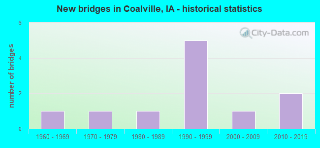
- New bridges - historical statistics
- 11960-1969
- 11970-1979
- 11980-1989
- 51990-1999
- 12000-2009
- 22010-2019


- Bridge Condition - Deck
- 33.3%Very good
- 50.0%Good
- 16.7%Fair

- Bridge Condition - Superstructure
- 33.3%Very good
- 50.0%Good
- 16.7%Satisfactory

- Bridge Condition - Substructure
- 33.3%Very good
- 50.0%Good
- 16.7%Satisfactory

- Bridge Condition - Channel
- 25.0%Very good
- 37.5%Good
- 25.0%Satisfactory
- 12.5%Fair

- Bridge Condition - Culverts
- 25.0%Excellent
- 25.0%Good
- 25.0%Satisfactory
- 25.0%Fair
Find on map >> Show street view
Structure Number: 342531, Location: 088280304 (Lat: 42.465856, Lng: -94.106944), Route carried "on" structure: County highway , Year Built: 2000, Status: Open, Structure Length: 1.01m (3.31ft), Average Daily Traffic: 30 (year 2019), Average Future Daily Traffic: 30 (year 2041), Design Load: HS 20, Features Intersected: HOLIDAY CREEK, Facility Carried by Structure: FM
Minimum Vertical Clearance: 30+ m (98+ ft), Kilometerpoint: 18.219, Lanes on structure: 2, Owner: County Highway Agency, Approaching Roadway Width: 8.8m (28.9ft), Material/Design: Concrete, Design/Construction: Slab, Number Of Spans In Main Unit: 1, Length of Maximum Span: 10.1m (33.1ft), Curb-To-Curb Width: 8.5m (27.9ft), Out-to-Out Width: 8.6m (28.2ft)
Condition: Deck: Good, Superstructure: Good, Substructure: Good, Channel: Very good, Operating Rating: 54.0 metric tons, Method Used To Determine Operating Rating: Load Factor (LF), Inventory Rating: 32.3 metric tons, Method Used To Determine Inventory Rating: Load Factor (LF), Structural Evaluation: Better than present minimum criteria, Deck Geometry: Better than present minimum criteria, Waterway Adequacy: Better than present minimum criteria, Approach Roadway Alignment: Better than present minimum criteria, Length Of Structure Improvement: 3.30m (10.83ft), Designated Inspection Frequency: Every 24 months, Inspection Date: November 2021, Bridge Improvement Cost: $15,000, Roadway Improvement Cost: $2,000, Deck Structure Type: Concrete Precast Panels, Wearing Surface/Protective System: Wearing Surface: Monolithic Concrete
Find on map >> Show street view
Structure Number: 342536, Location: 088280512 (Lat: 42.464192, Lng: -94.127886), Route carried "on" structure: County highway , Year Built: 2010, Status: Open, Structure Length: 3.75m (12.30ft), Average Daily Traffic: 7,600 (year 2019), Truck Traffic: 11%, Average Future Daily Traffic: 7,600 (year 2041), Design Load: HL 93, Features Intersected: QUARRY HAUL RD, Facility Carried by Structure: QUAIL AVE
Minimum Vertical Clearance: 30+ m (98+ ft), Kilometerpoint: 19.216, Lanes on structure: 2, Lanes under structure: 2, Base Highway Network: Yes, Owner: County Highway Agency, Approaching Roadway Width: 8.5m (27.9ft), Material/Design: Concrete continuous, Design/Construction: Slab, Number Of Spans In Main Unit: 3, Length of Maximum Span: 14.3m (46.9ft), Curb-To-Curb Width: 13.4m (44.0ft), Out-to-Out Width: 14.3m (46.9ft)
Condition: Deck: Very good, Superstructure: Very good, Substructure: Very good, Operating Rating: 55.7 metric tons, Method Used To Determine Operating Rating: Load and Resistance Factor Rating (LRFR) rating reported by rating factor(RF) method using HL-93 loadings, Inventory Rating: 43.1 metric tons, Method Used To Determine Inventory Rating: Load and Resistance Factor Rating (LRFR) rating reported by rating factor(RF) method using HL-93 loadings, Structural Evaluation: Equal to present desirable criteria, Deck Geometry: Equal to present minimum criteria, Approach Roadway Alignment: Equal to present desirable criteria, Designated Inspection Frequency: Every 24 months, Inspection Date: November 2021, Deck Structure Type: Concrete Cast-file-Place, Wearing Surface/Protective System: Wearing Surface: Monolithic Concrete, Deck Protection: Epoxy Coated Reinforcing
Find on map >> Show street view
Structure Number: 342561, Location: 088281007 (Lat: 42.448742, Lng: -94.102033), Route carried "on" structure: County highway , Year Built: 1974, Status: Open, Structure Length: 0.73m (2.40ft), Average Daily Traffic: 540 (year 2019), Truck Traffic: 13%, Average Future Daily Traffic: 540 (year 2041), Design Load: HS 20, Features Intersected: HOLIDAY CREEK, Facility Carried by Structure: FM
Minimum Vertical Clearance: 30+ m (98+ ft), Kilometerpoint: 5.544, Lanes on structure: 2, Owner: County Highway Agency, Approaching Roadway Width: 9.8m (32.2ft), Material/Design: Concrete, Design/Construction: Culvert, Number Of Spans In Main Unit: 1, Length of Maximum Span: 7.3m (24.0ft)
Condition: Channel: Fair, Culverts: Fair, Operating Rating: 44.1 metric tons, Method Used To Determine Operating Rating: Assigned rating based on Load Factor Design (LFD) reported in metric tons, Inventory Rating: 32.7 metric tons, Method Used To Determine Inventory Rating: Assigned rating based on Load Factor Design (LFD) reported in metric tons, Structural Evaluation: Somewhat better than minimum adequacy, Waterway Adequacy: Equal to present desirable criteria, Approach Roadway Alignment: Equal to present desirable criteria, Length Of Structure Improvement: 2.40m (7.87ft), Designated Inspection Frequency: Every 24 months, Inspection Date: November 2021, Bridge Improvement Cost: $15,000, Roadway Improvement Cost: $2,000
Find on map >> Show street view
Structure Number: 342581, Location: 088281706 (Lat: 42.438581, Lng: -94.141092), Route carried "on" structure: County highway , Year Built: 1965, Status: Open, Structure Length: 0.82m (2.69ft), Average Daily Traffic: 200 (year 2019), Average Future Daily Traffic: 200 (year 2041), Design Load: H 20, Features Intersected: SMALL STREAM, Facility Carried by Structure: FM
Minimum Vertical Clearance: 30+ m (98+ ft), Kilometerpoint: 1.798, Lanes on structure: 2, Owner: County Highway Agency, Approaching Roadway Width: 10.1m (33.1ft), Skew: 1 degrees, Material/Design: Concrete continuous, Design/Construction: Culvert, Number Of Spans In Main Unit: 2, Length of Maximum Span: 3.7m (12.1ft)
Condition: Channel: Satisfactory, Culverts: Satisfactory, Operating Rating: 56.2 metric tons, Method Used To Determine Operating Rating: Load Factor (LF), Inventory Rating: 33.7 metric tons, Method Used To Determine Inventory Rating: Load Factor (LF), Structural Evaluation: Equal to present minimum criteria, Waterway Adequacy: Equal to present minimum criteria, Approach Roadway Alignment: Better than present minimum criteria, Length Of Structure Improvement: 2.70m (8.86ft), Designated Inspection Frequency: Every 48 months, Inspection Date: November 2021, Bridge Improvement Cost: $15,000, Roadway Improvement Cost: $2,000
Find on map >> Show street view
Structure Number: 342591, Location: 088281714 (Lat: 42.431472, Lng: -94.132422), Route carried "on" structure: County highway , Year Built: 1995, Status: Open, Structure Length: 14.51m (47.60ft), Average Daily Traffic: 1,750 (year 2019), Truck Traffic: 9%, Average Future Daily Traffic: 1,750 (year 2040), Design Load: HS 20, Features Intersected: DES MOINES RIVER, Facility Carried by Structure: FM
Minimum Vertical Clearance: 30+ m (98+ ft), Kilometerpoint: 24.618, Lanes on structure: 2, Owner: County Highway Agency, Approaching Roadway Width: 9.8m (32.2ft), Skew: 1 degrees, Material/Design: Prestressed concrete, Design/Construction: Stringer/Multi-beam, Number Of Spans In Main Unit: 5, Length of Maximum Span: 39.9m (130.9ft), Curb or Sidewalk Widths: Left: 1.8m (5.9ft), Right: 0.0m, Curb-To-Curb Width: 9.1m (29.9ft), Out-to-Out Width: 12.2m (40.0ft)
Condition: Deck: Very good, Superstructure: Very good, Substructure: Very good, Channel: Good, Operating Rating: 71.2 metric tons, Method Used To Determine Operating Rating: Load Factor (LF), Inventory Rating: 42.6 metric tons, Method Used To Determine Inventory Rating: Load Factor (LF), Structural Evaluation: Equal to present desirable criteria, Deck Geometry: Somewhat better than minimum adequacy, Waterway Adequacy: Equal to present desirable criteria, Approach Roadway Alignment: Equal to present minimum criteria, Length Of Structure Improvement: 47.60m (156.17ft), Designated Inspection Frequency: Every 24 months, Inspection Date: November 2020, Bridge Improvement Cost: $17,000, Roadway Improvement Cost: $5,000, Deck Structure Type: Concrete Cast-file-Place, Wearing Surface/Protective System: Wearing Surface: Monolithic Concrete, Deck Protection: Epoxy Coated Reinforcing
Find on map >> Show street view
Structure Number: 342631, Location: 088282804 (Lat: 42.403008, Lng: -94.116475), Route carried "on" structure: County highway , Year Built: 2019, Status: Open, Structure Length: 1.07m (3.51ft), Average Daily Traffic: 80 (year 2019), Average Future Daily Traffic: 80 (year 2040), Design Load: HL 93, Features Intersected: PRAIRIE CREEK, Facility Carried by Structure: OSCEOLA AVE
Minimum Vertical Clearance: 30+ m (98+ ft), Kilometerpoint: 2.163, Lanes on structure: 2, Owner: County Highway Agency, Approaching Roadway Width: 8.5m (27.9ft), Skew: 3 degrees, Material/Design: Concrete, Design/Construction: Culvert, Number Of Spans In Main Unit: 2, Length of Maximum Span: 4.9m (16.1ft)
Condition: Channel: Very good, Culverts: Excellent, Operating Rating: 49.6 metric tons, Method Used To Determine Operating Rating: Load and Resistance Factor Rating (LRFR) rating reported by rating factor(RF) method using HL-93 loadings, Inventory Rating: 38.2 metric tons, Method Used To Determine Inventory Rating: Load and Resistance Factor Rating (LRFR) rating reported by rating factor(RF) method using HL-93 loadings, Structural Evaluation: Superior to present desirable criteria, Waterway Adequacy: Equal to present desirable criteria, Approach Roadway Alignment: Equal to present minimum criteria, Designated Inspection Frequency: Every 24 months, Inspection Date: November 2020
Find on map >> Show street view
Structure Number: 605748, Location: 3.1 mi. E of US 169 (Lat: 42.450486, Lng: -94.124078), Route carried "on" structure: County highway , Year Built: 1990, Status: Open, Structure Length: 10.76m (35.30ft), Average Daily Traffic: 5,500 (year 2019), Truck Traffic: 9%, Average Future Daily Traffic: 5,500 (year 2040), Design Load: HS 20, Features Intersected: US 20, Facility Carried by Structure: P59 (QUAIL AVE)
Minimum Vertical Clearance: 30+ m (98+ ft), Kilometerpoint: 17.513, Lanes on structure: 2, Lanes under structure: 5, Owner: State Highway Agency, Approaching Roadway Width: 19.5m (64.0ft), Skew: 2 degrees, Material/Design: Steel continuous, Design/Construction: Stringer/Multi-beam, Number Of Spans In Main Unit: 4, Length of Maximum Span: 35.7m (117.1ft), Curb-To-Curb Width: 18.3m (60.0ft), Out-to-Out Width: 19.3m (63.3ft)
Condition: Deck: Good, Superstructure: Good, Substructure: Good, Operating Rating: 61.6 metric tons, Method Used To Determine Operating Rating: Load Factor (LF), Inventory Rating: 36.9 metric tons, Method Used To Determine Inventory Rating: Load Factor (LF), Structural Evaluation: Better than present minimum criteria, Deck Geometry: Superior to present desirable criteria, Underclear: Superior to present desirable criteria, Approach Roadway Alignment: Equal to present desirable criteria, Designated Inspection Frequency: Every 24 months, Inspection Date: May 2020, Deck Structure Type: Concrete Cast-file-Place, Wearing Surface/Protective System: Wearing Surface: Monolithic Concrete, Deck Protection: Epoxy Coated Reinforcing
Find on map >> Show street view
Structure Number: 60575, Location: 1.0 mi. E of SR P39 (Lat: 42.449564, Lng: -94.102689), Route carried "on" structure: US 20, Year Built: 1986, Status: Open, Structure Length: 0.73m (2.40ft), Average Daily Traffic: 8,900 (year 2020), Truck Traffic: 25%, Average Future Daily Traffic: 8,900 (year 2041), Design Load: HS 20, Features Intersected: HOLLIDAY CREEK
Minimum Vertical Clearance: 30+ m (98+ ft), Kilometerpoint: 191.531, Lanes on structure: 6, Base Highway Network: Yes, Owner: State Highway Agency, Approaching Roadway Width: 24.4m (80.1ft), Skew: 20 degrees, Material/Design: Concrete, Design/Construction: Culvert, Number Of Spans In Main Unit: 1, Length of Maximum Span: 7.3m (24.0ft)
Condition: Channel: Satisfactory, Culverts: Good, Operating Rating: 44.1 metric tons, Method Used To Determine Operating Rating: No rating analysis performed, Inventory Rating: 32.7 metric tons, Method Used To Determine Inventory Rating: No rating analysis performed, Structural Evaluation: Better than present minimum criteria, Waterway Adequacy: Equal to present minimum criteria, Approach Roadway Alignment: Equal to present desirable criteria, Designated Inspection Frequency: Every 24 months, Inspection Date: July 2021
Find on map >> Show street view
Structure Number: 606085, Location: 2.6 MI. E OF JCT. US 169 (Lat: 42.447661, Lng: -94.136003), Route carried "on" structure: US 20, Year Built: 1990, Status: Open, Structure Length: 20.60m (67.59ft), Average Daily Traffic: 3,900 (year 2020), Truck Traffic: 29%, Average Future Daily Traffic: 3,900 (year 2040), Design Load: HS 20, Features Intersected: DES MOINES RIVER
Minimum Vertical Clearance: 30+ m (98+ ft), Kilometerpoint: 188.725, Lanes on structure: 2, Base Highway Network: Yes, Owner: State Highway Agency, Approaching Roadway Width: 12.2m (40.0ft), Skew: 2 degrees, Material/Design: Steel continuous, Design/Construction: Stringer/Multi-beam, Number Of Spans In Main Unit: 5, Length of Maximum Span: 44.8m (147.0ft), Curb-To-Curb Width: 12.2m (40.0ft), Out-to-Out Width: 13.2m (43.3ft)
Condition: Deck: Good, Superstructure: Good, Substructure: Satisfactory, Channel: Good, Operating Rating: 45.9 metric tons, Method Used To Determine Operating Rating: Load Factor (LF), Inventory Rating: 27.6 metric tons, Method Used To Determine Inventory Rating: Load Factor (LF), Structural Evaluation: Equal to present minimum criteria, Deck Geometry: Better than present minimum criteria, Waterway Adequacy: Superior to present desirable criteria, Approach Roadway Alignment: Equal to present desirable criteria, Designated Inspection Frequency: Every 24 months, Underwater Inspection Frequency: Every 48 months, Inspection Date: May 2020, Underwater Inspection Date: May 2018, Deck Structure Type: Concrete Cast-file-Place, Wearing Surface/Protective System: Wearing Surface: Monolithic Concrete, Deck Protection: Epoxy Coated Reinforcing
Find on map >> Show street view
Structure Number: 60609, Location: 2.6 mi. E of US 169 (Lat: 42.448542, Lng: -94.133769), Route carried "on" structure: US 20, Year Built: 1990, Status: Open, Structure Length: 20.60m (67.59ft), Average Daily Traffic: 3,900 (year 2020), Truck Traffic: 29%, Average Future Daily Traffic: 3,900 (year 2040), Design Load: HS 20, Features Intersected: DES MOINES RIVER
Minimum Vertical Clearance: 30+ m (98+ ft), Kilometerpoint: 294.267, Lanes on structure: 2, Owner: State Highway Agency, Approaching Roadway Width: 12.2m (40.0ft), Skew: 2 degrees, Material/Design: Steel continuous, Design/Construction: Stringer/Multi-beam, Number Of Spans In Main Unit: 5, Length of Maximum Span: 44.8m (147.0ft), Curb-To-Curb Width: 12.2m (40.0ft), Out-to-Out Width: 13.2m (43.3ft)
Condition: Deck: Fair, Superstructure: Satisfactory, Substructure: Good, Channel: Good, Operating Rating: 45.9 metric tons, Method Used To Determine Operating Rating: Load Factor (LF), Inventory Rating: 27.6 metric tons, Method Used To Determine Inventory Rating: Load Factor (LF), Structural Evaluation: Equal to present minimum criteria, Deck Geometry: Better than present minimum criteria, Waterway Adequacy: Superior to present desirable criteria, Approach Roadway Alignment: Equal to present desirable criteria, Designated Inspection Frequency: Every 24 months, Inspection Date: May 2020, Deck Structure Type: Concrete Cast-file-Place, Wearing Surface/Protective System: Wearing Surface: Monolithic Concrete, Deck Protection: Epoxy Coated Reinforcing
Find on map >> Show street view
Structure Number: 605748, Location: 3.1 mi. E of US 169 (Lat: 42.450486, Lng: -94.124078), Route carried "under" structure: US 20, Year Built: 1990, Structure Length: 0. m, Average Daily Traffic: 6,200 (year 2020), Truck Traffic: 30%, Features Intersected: US 20, Facility Carried by Structure: P59 (QUAIL AVE)
Minimum Vertical Clearance: 30+ m (98+ ft), Kilometerpoint: 189.767, Lanes on structure: 2, Lanes under structure: 5, Material/Design: Steel continuous, Design/Construction: Stringer/Multi-beam, Length of Maximum Span: 35.7m (117.1ft)