Bridge Statistics for Cobleskill, New York (NY)
Condition, Traffic, Stress, Structural Evaluation, Project Costs
- National Bridge Inventory (NBI) Statistics
- 46Number of bridges
- 318ft / 97.4mTotal length
- $63,683,000Total costs
- 122,653Total average daily traffic
- 13,655Total average daily truck traffic
- National Bridge Inventory (NBI) Registered Bridges for Cobleskill
- No street view available for this location
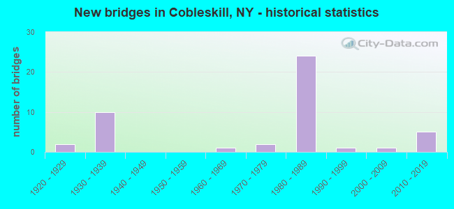
- New bridges - historical statistics
- 21920-1929
- 101930-1939
- 11960-1969
- 21970-1979
- 241980-1989
- 11990-1999
- 12000-2009
- 52010-2019

- Reconstructed bridges - Historical Statistics
- 21990-1999
- 22000-2009


- Bridge Condition - Deck
- 10.7%Excellent
- 17.9%Very good
- 39.3%Good
- 14.3%Satisfactory
- 14.3%Fair
- 3.6%Poor

- Bridge Condition - Superstructure
- 6.9%Excellent
- 13.8%Very good
- 58.6%Good
- 6.9%Satisfactory
- 10.3%Fair
- 3.4%Poor

- Bridge Condition - Substructure
- 13.8%Excellent
- 10.3%Very good
- 48.3%Good
- 10.3%Satisfactory
- 13.8%Fair
- 3.4%Poor

- Bridge Condition - Channel
- 20.0%Very good
- 35.0%Good
- 15.0%Satisfactory
- 20.0%Fair
- 10.0%Poor

- Bridge Condition - Culverts
- 50.0%Good
- 50.0%Satisfactory
Find on map >> Show street view
Structure Number: 100408, Location: 0.1 MI S OF COBLESKILL (Lat: 42.667308, Lng: -74.503167), Route carried "on" structure: State highway 7, Year Built: 1992, Status: Open, Structure Length: 5.67m (18.60ft), Average Daily Traffic: 6,117 (year 2020), Truck Traffic: 6%, Average Future Daily Traffic: 7,430 (year 2040), Design Load: HS 20, Features Intersected: COBLESKILL CREEK
Minimum Vertical Clearance: 30+ m (98+ ft), Kilometerpoint: 13.017, Lanes on structure: 2, Base Highway Network: Yes, Owner: State Highway Agency, Approaching Roadway Width: 11.6m (38.1ft), Skew: 3 degrees, Material/Design: Steel, Design/Construction: Stringer/Multi-beam, Number Of Spans In Main Unit: 1, Length of Maximum Span: 56.0m (183.7ft), Curb-To-Curb Width: 11.6m (38.1ft), Out-to-Out Width: 12.2m (40.0ft)
Condition: Deck: Good, Superstructure: Good, Substructure: Very good, Channel: Good, Operating Rating: 48.1 metric tons, Method Used To Determine Operating Rating: Load Factor (LF), Inventory Rating: 29.0 metric tons, Method Used To Determine Inventory Rating: Load Factor (LF), Structural Evaluation: Better than present minimum criteria, Deck Geometry: Somewhat better than minimum adequacy, Waterway Adequacy: Equal to present minimum criteria, Approach Roadway Alignment: Equal to present desirable criteria, Length Of Structure Improvement: 5.66m (18.57ft), Designated Inspection Frequency: Every 24 months, Inspection Date: September 2020, Bridge Improvement Cost: $1,740,000, Roadway Improvement Cost: $1,019,000, Total Project Cost: $2,760,000 ( Estimate for 2021), Deck Structure Type: Concrete Cast-file-Place, Wearing Surface/Protective System: Wearing Surface: Integral Concrete, Deck Protection: Epoxy Coated Reinforcing
Find on map >> Show street view
Structure Number: 100409, Location: IN COBLESKILL (Lat: 42.676039, Lng: -74.493092), Route carried "on" structure: State highway 7, Year Built: 2011, Status: Open, Structure Length: 2.62m (8.60ft), Average Daily Traffic: 6,117 (year 2020), Truck Traffic: 6%, Average Future Daily Traffic: 7,430 (year 2040), Design Load: HL 93, Features Intersected: NORFOLK SOUTHERN
Minimum Vertical Clearance: 30+ m (98+ ft), Kilometerpoint: 14.401, Lanes on structure: 2, Base Highway Network: Yes, Owner: State Highway Agency, Approaching Roadway Width: 9.4m (30.8ft), Skew: 6 degrees, Material/Design: Concrete, Design/Construction: Frame, Number Of Spans In Main Unit: 1, Length of Maximum Span: 24.7m (81.0ft), Curb or Sidewalk Widths: Left: 1.5m (4.9ft), Right: 1.5m (4.9ft), Curb-To-Curb Width: 9.6m (31.5ft), Out-to-Out Width: 16.6m (54.5ft)
Condition: Deck: Very good, Superstructure: Very good, Substructure: Very good, Operating Rating: 61.7 metric tons, Method Used To Determine Operating Rating: Load Factor (LF), Inventory Rating: 36.3 metric tons, Method Used To Determine Inventory Rating: Load Factor (LF), Structural Evaluation: Equal to present desirable criteria, Deck Geometry: High priority of corrective action, Underclear: Meets minimum limits, Approach Roadway Alignment: Equal to present desirable criteria, Length Of Structure Improvement: 2.62m (8.60ft), Designated Inspection Frequency: Every 24 months, Inspection Date: August 2021, Bridge Improvement Cost: $2,270,000, Roadway Improvement Cost: $1,329,000, Total Project Cost: $3,599,000 ( Estimate for 2021), Wearing Surface/Protective System: Wearing Surface: Bituminous, Membrane: Preformed Fabric
Find on map >> Show street view
Structure Number: 10041, Location: IN VILLAGE OF COBLESKILL (Lat: 42.677608, Lng: -74.487053), Route carried "on" structure: State highway 7, Year Built: 2000, Status: Open, Structure Length: 0.76m (2.49ft), Average Daily Traffic: 6,117 (year 2020), Truck Traffic: 6%, Average Future Daily Traffic: 7,430 (year 2040), Design Load: HS 25 or greater, Features Intersected: MILL CREEK
Minimum Vertical Clearance: 30+ m (98+ ft), Kilometerpoint: 15.012, Lanes on structure: 2, Base Highway Network: Yes, Owner: State Highway Agency, Approaching Roadway Width: 12.5m (41.0ft), Material/Design: Concrete, Design/Construction: Culvert, Number Of Spans In Main Unit: 1, Length of Maximum Span: 7.4m (24.3ft), Curb or Sidewalk Widths: Left: 1.5m (4.9ft), Right: 1.5m (4.9ft), Curb-To-Curb Width: 12.2m (40.0ft), Out-to-Out Width: 15.9m (52.2ft)
Condition: Channel: Good, Culverts: Good, Operating Rating: 81.6 metric tons, Method Used To Determine Operating Rating: Load Factor (LF), Inventory Rating: 49.0 metric tons, Method Used To Determine Inventory Rating: Load Factor (LF), Structural Evaluation: Better than present minimum criteria, Deck Geometry: Somewhat better than minimum adequacy, Waterway Adequacy: Somewhat better than minimum adequacy, Approach Roadway Alignment: Equal to present desirable criteria, Length Of Structure Improvement: 0.76m (2.49ft), Designated Inspection Frequency: Every 24 months, Inspection Date: September 2020, Bridge Improvement Cost: $215,000, Roadway Improvement Cost: $126,000, Total Project Cost: $341,000 ( Estimate for 2021)
Find on map >> Show street view
Structure Number: 100412, Location: AT COBLESKILL (Lat: 42.680194, Lng: -74.467489), Route carried "on" structure: State highway 7, Year Built: 1937, Year Reconstructed: 2005, Status: Open, Structure Length: 4.63m (15.19ft), Average Daily Traffic: 9,607 (year 2017), Truck Traffic: 5%, Average Future Daily Traffic: 11,670 (year 2040), Design Load: HS 20, Features Intersected: COBLESKILL CREEK
Minimum Vertical Clearance: 4.46m (14.63ft), Kilometerpoint: 16.621, Lanes on structure: 2, Base Highway Network: Yes, Owner: State Highway Agency, Approaching Roadway Width: 7.9m (25.9ft), Material/Design: Steel, Design/Construction: Truss - Thru, Number Of Spans In Main Unit: 1, Length of Maximum Span: 44.0m (144.4ft), Curb or Sidewalk Widths: Left: 1.5m (4.9ft), Right: 0.0m, Curb-To-Curb Width: 8.5m (27.9ft), Out-to-Out Width: 9.3m (30.5ft)
Condition: Deck: Good, Superstructure: Satisfactory, Substructure: Satisfactory, Channel: Satisfactory, Operating Rating: 48.1 metric tons, Method Used To Determine Operating Rating: Load Factor (LF), Inventory Rating: 28.1 metric tons, Method Used To Determine Inventory Rating: Load Factor (LF), Structural Evaluation: Equal to present minimum criteria, Deck Geometry: High priority of replacement, Waterway Adequacy: Meets minimum limits, Approach Roadway Alignment: Equal to present desirable criteria, Length Of Structure Improvement: 4.63m (15.19ft), Designated Inspection Frequency: Every 24 months, Critical Feature Inspection Frequency: Every 24 months, Inspection Date: November 2020, Critical Feature Inspection Date: November 2020, Bridge Improvement Cost: $3,236,000, Roadway Improvement Cost: $1,895,000, Total Project Cost: $5,132,000 ( Estimate for 2021), Deck Structure Type: Concrete Cast-file-Place, Wearing Surface/Protective System: Wearing Surface: Integral Concrete, Deck Protection: Epoxy Coated Reinforcing
Find on map >> Show street view
Structure Number: 103828, Location: .1 MI N JCT SH 145 & SH 1 (Lat: 42.680417, Lng: -74.488997), Route carried "on" structure: State highway 145, Year Built: 1989, Status: Open, Structure Length: 1.25m (4.10ft), Average Daily Traffic: 2,389 (year 2018), Truck Traffic: 6%, Average Future Daily Traffic: 2,902 (year 2040), Design Load: HS 20, Features Intersected: MILL CREEK
Minimum Vertical Clearance: 30+ m (98+ ft), Kilometerpoint: 36.396, Lanes on structure: 2, Base Highway Network: Yes, Owner: State Highway Agency, Approaching Roadway Width: 8.5m (27.9ft), Skew: 6 degrees, Material/Design: Prestressed concrete, Design/Construction: Box Beam or Girders - Multiple, Number Of Spans In Main Unit: 1, Length of Maximum Span: 12.4m (40.7ft), Curb or Sidewalk Widths: Left: 1.5m (4.9ft), Right: 1.5m (4.9ft), Curb-To-Curb Width: 8.5m (27.9ft), Out-to-Out Width: 12.2m (40.0ft)
Condition: Deck: Fair, Superstructure: Good, Substructure: Good, Channel: Good, Operating Rating: 71.7 metric tons, Method Used To Determine Operating Rating: Load Factor (LF), Inventory Rating: 38.1 metric tons, Method Used To Determine Inventory Rating: Load Factor (LF), Structural Evaluation: Better than present minimum criteria, Deck Geometry: Meets minimum limits, Waterway Adequacy: Equal to present desirable criteria, Approach Roadway Alignment: Equal to present desirable criteria, Length Of Structure Improvement: 1.28m (4.20ft), Designated Inspection Frequency: Every 24 months, Inspection Date: June 2020, Bridge Improvement Cost: $861,000, Roadway Improvement Cost: $504,000, Total Project Cost: $1,365,000 ( Estimate for 2021), Wearing Surface/Protective System: Wearing Surface: Monolithic Concrete
Find on map >> Show street view
Structure Number: 10702, Location: 2 MILES SW OF COBLESKILL (Lat: 42.654453, Lng: -74.509253), Route carried "on" structure: Other road 992L, Year Built: 1980, Status: Open, Structure Length: 7.56m (24.80ft), Average Daily Traffic: 2,321 (year 2017), Truck Traffic: 7%, Average Future Daily Traffic: 2,871 (year 2040), Design Load: HS 20, Features Intersected: 88I 88I95071068WB, RTE I
Minimum Vertical Clearance: 30+ m (98+ ft), Kilometerpoint: 0.032, Lanes on structure: 3, Lanes under structure: 4, Base Highway Network: Yes, Owner: State Highway Agency, Approaching Roadway Width: 15.8m (51.8ft), Skew: 22 degrees, Material/Design: Steel, Design/Construction: Stringer/Multi-beam, Number Of Spans In Main Unit: 2, Length of Maximum Span: 36.8m (120.7ft), Curb-To-Curb Width: 15.5m (50.9ft), Out-to-Out Width: 16.5m (54.1ft)
Condition: Deck: Good, Superstructure: Good, Substructure: Good, Operating Rating: 99.8 metric tons, Method Used To Determine Operating Rating: Load Factor (LF), Inventory Rating: 59.9 metric tons, Method Used To Determine Inventory Rating: Load Factor (LF), Structural Evaluation: Better than present minimum criteria, Deck Geometry: Equal to present minimum criteria, Underclear: Equal to present minimum criteria, Approach Roadway Alignment: Equal to present desirable criteria, Length Of Structure Improvement: 7.55m (24.77ft), Designated Inspection Frequency: Every 24 months, Inspection Date: July 2021, Bridge Improvement Cost: $3,259,000, Roadway Improvement Cost: $1,908,000, Total Project Cost: $5,167,000 ( Estimate for 2021), Deck Structure Type: Concrete Cast-file-Place, Wearing Surface/Protective System: Wearing Surface: Integral Concrete, Deck Protection: Epoxy Coated Reinforcing
Find on map >> Show street view
Structure Number: 1070211, Location: 2 MILES SW OF COBLESKILL (Lat: 42.658281, Lng: -74.502844), Route carried "on" structure: Interstate 88, Year Built: 1980, Status: Open, Structure Length: 4.30m (14.11ft), Average Daily Traffic: 4,506 (year 2009), Truck Traffic: 28%, Design Load: HS 20+Mod, Features Intersected: W FULTON RD CR 4
Minimum Vertical Clearance: 30+ m (98+ ft), Kilometerpoint: 11.697, Lanes on structure: 2, Lanes under structure: 2, Base Highway Network: Yes, Owner: State Highway Agency, Approaching Roadway Width: 12.2m (40.0ft), Skew: 1 degrees, Material/Design: Steel, Design/Construction: Stringer/Multi-beam, Number Of Spans In Main Unit: 1, Length of Maximum Span: 41.4m (135.8ft), Curb-To-Curb Width: 12.6m (41.3ft), Out-to-Out Width: 13.5m (44.3ft)
Condition: Deck: Satisfactory, Superstructure: Good, Substructure: Good, Operating Rating: 66.1 metric tons, Method Used To Determine Operating Rating: Load and Resistance Factor Rating (LRFR) rating reported by rating factor(RF) method using HL-93 loadings, Inventory Rating: 50.9 metric tons, Method Used To Determine Inventory Rating: Load and Resistance Factor Rating (LRFR) rating reported by rating factor(RF) method using HL-93 loadings, Structural Evaluation: Better than present minimum criteria, Deck Geometry: Better than present minimum criteria, Underclear: Superior to present desirable criteria, Approach Roadway Alignment: Equal to present desirable criteria, Length Of Structure Improvement: 4.29m (14.07ft), Designated Inspection Frequency: Every 24 months, Inspection Date: May 2021, Bridge Improvement Cost: $1,641,000, Roadway Improvement Cost: $961,000, Total Project Cost: $2,603,000 ( Estimate for 2021), Deck Structure Type: Concrete Cast-file-Place, Wearing Surface/Protective System: Wearing Surface: Epoxy Overlay, Deck Protection: Epoxy Coated Reinforcing
Find on map >> Show street view
Structure Number: 1070212, Location: 2 MILES SW OF COBLESKILL (Lat: 42.657981, Lng: -74.502669), Route carried "on" structure: Interstate 88, Year Built: 1980, Status: Open, Structure Length: 4.30m (14.11ft), Average Daily Traffic: 4,770 (year 2019), Truck Traffic: 24%, Average Future Daily Traffic: 6,274 (year 2040), Design Load: HS 20+Mod, Features Intersected: W FULTON RD CR 4
Minimum Vertical Clearance: 30+ m (98+ ft), Kilometerpoint: 11.681, Lanes on structure: 2, Lanes under structure: 2, Base Highway Network: Yes, Owner: State Highway Agency, Approaching Roadway Width: 12.2m (40.0ft), Skew: 1 degrees, Material/Design: Steel, Design/Construction: Stringer/Multi-beam, Number Of Spans In Main Unit: 1, Length of Maximum Span: 41.4m (135.8ft), Curb-To-Curb Width: 12.5m (41.0ft), Out-to-Out Width: 13.5m (44.3ft)
Condition: Deck: Satisfactory, Superstructure: Good, Substructure: Good, Operating Rating: 66.1 metric tons, Method Used To Determine Operating Rating: Load and Resistance Factor Rating (LRFR) rating reported by rating factor(RF) method using HL-93 loadings, Inventory Rating: 50.9 metric tons, Method Used To Determine Inventory Rating: Load and Resistance Factor Rating (LRFR) rating reported by rating factor(RF) method using HL-93 loadings, Structural Evaluation: Better than present minimum criteria, Deck Geometry: Better than present minimum criteria, Underclear: Superior to present desirable criteria, Approach Roadway Alignment: Equal to present desirable criteria, Length Of Structure Improvement: 4.29m (14.07ft), Designated Inspection Frequency: Every 24 months, Inspection Date: May 2021, Bridge Improvement Cost: $1,710,000, Roadway Improvement Cost: $1,001,000, Total Project Cost: $2,711,000 ( Estimate for 2021), Deck Structure Type: Concrete Cast-file-Place, Wearing Surface/Protective System: Wearing Surface: Epoxy Overlay, Deck Protection: Epoxy Coated Reinforcing
Find on map >> Show street view
Structure Number: 107022, Location: 2 MI SW OF COBLESKILL (Lat: 42.657050, Lng: -74.511233), Route carried "on" structure: Alternate State highway 7, Year Built: 1979, Status: Open, Structure Length: 0.76m (2.49ft), Average Daily Traffic: 4,838 (year 2019), Truck Traffic: 6%, Average Future Daily Traffic: 5,877 (year 2040), Design Load: HS 20, Features Intersected: MICKLE CREEK
Minimum Vertical Clearance: 30+ m (98+ ft), Kilometerpoint: 11.633, Lanes on structure: 2, Base Highway Network: Yes, Owner: State Highway Agency, Approaching Roadway Width: 17.7m (58.1ft), Material/Design: Concrete, Design/Construction: Culvert, Number Of Spans In Main Unit: 1, Length of Maximum Span: 6.7m (22.0ft), Curb-To-Curb Width: 17.7m (58.1ft), Out-to-Out Width: 18.3m (60.0ft)
Condition: Channel: Good, Culverts: Satisfactory, Operating Rating: 52.8 metric tons, Method Used To Determine Operating Rating: Load and Resistance Factor Rating (LRFR) rating reported by rating factor(RF) method using HL-93 loadings, Inventory Rating: 40.8 metric tons, Method Used To Determine Inventory Rating: Load and Resistance Factor Rating (LRFR) rating reported by rating factor(RF) method using HL-93 loadings, Structural Evaluation: Equal to present minimum criteria, Deck Geometry: Superior to present desirable criteria, Waterway Adequacy: Somewhat better than minimum adequacy, Approach Roadway Alignment: Equal to present desirable criteria, Length Of Structure Improvement: 0.76m (2.49ft), Designated Inspection Frequency: Every 24 months, Inspection Date: May 2021, Bridge Improvement Cost: $524,000, Roadway Improvement Cost: $307,000, Total Project Cost: $830,000 ( Estimate for 2021)
Find on map >> Show street view
Structure Number: 1070971, Location: 3.8 MI S JCT I88 & SH 145 (Lat: 42.667917, Lng: -74.489436), Route carried "on" structure: Interstate 88, Year Built: 1980, Status: Open, Structure Length: 5.18m (16.99ft), Average Daily Traffic: 628 (year 2016), Truck Traffic: 5%, Average Future Daily Traffic: 634 (year 2039), Design Load: HS 20, Features Intersected: CR1-MINERL SPR RD
Minimum Vertical Clearance: 30+ m (98+ ft), Kilometerpoint: 0.965, Lanes on structure: 2, Lanes under structure: 2, Base Highway Network: Yes, Owner: State Highway Agency, Approaching Roadway Width: 12.8m (42.0ft), Skew: 4 degrees, Material/Design: Steel, Design/Construction: Stringer/Multi-beam, Number Of Spans In Main Unit: 1, Length of Maximum Span: 49.9m (163.7ft), Curb-To-Curb Width: 12.5m (41.0ft), Out-to-Out Width: 13.4m (44.0ft)
Condition: Deck: Excellent, Superstructure: Good, Substructure: Good, Inventory Rating: 65.3 metric tons, Method Used To Determine Inventory Rating: Load Factor (LF), Structural Evaluation: Better than present minimum criteria, Deck Geometry: Better than present minimum criteria, Underclear: Equal to present minimum criteria, Approach Roadway Alignment: Equal to present desirable criteria, Length Of Structure Improvement: 5.18m (16.99ft), Designated Inspection Frequency: Every 24 months, Inspection Date: August 2020, Bridge Improvement Cost: $2,008,000, Roadway Improvement Cost: $1,176,000, Total Project Cost: $3,184,000 ( Estimate for 2021), Deck Structure Type: Concrete Cast-file-Place, Wearing Surface/Protective System: Wearing Surface: Integral Concrete, Deck Protection: Epoxy Coated Reinforcing
Find on map >> Show street view
Structure Number: 1070972, Location: 1.2 MI S JCT SH 10 & SH 1 (Lat: 42.667844, Lng: -74.488828), Route carried "on" structure: Interstate 88, Year Built: 1980, Status: Open, Structure Length: 4.18m (13.71ft), Average Daily Traffic: 4,770 (year 2019), Truck Traffic: 24%, Average Future Daily Traffic: 6,274 (year 2040), Design Load: HS 20, Features Intersected: CR1-MINERL SPR RD
Minimum Vertical Clearance: 30+ m (98+ ft), Kilometerpoint: 13.258, Lanes on structure: 2, Lanes under structure: 2, Base Highway Network: Yes, Owner: State Highway Agency, Approaching Roadway Width: 12.8m (42.0ft), Skew: 4 degrees, Material/Design: Steel, Design/Construction: Stringer/Multi-beam, Number Of Spans In Main Unit: 1, Length of Maximum Span: 39.9m (130.9ft), Curb-To-Curb Width: 12.5m (41.0ft), Out-to-Out Width: 13.4m (44.0ft)
Condition: Deck: Excellent, Superstructure: Good, Substructure: Good, Inventory Rating: 73.5 metric tons, Method Used To Determine Inventory Rating: Load Factor (LF), Structural Evaluation: Better than present minimum criteria, Deck Geometry: Better than present minimum criteria, Underclear: Equal to present minimum criteria, Approach Roadway Alignment: Equal to present desirable criteria, Length Of Structure Improvement: 4.17m (13.68ft), Designated Inspection Frequency: Every 24 months, Inspection Date: August 2020, Bridge Improvement Cost: $1,720,000, Roadway Improvement Cost: $1,007,000, Total Project Cost: $2,727,000 ( Estimate for 2021), Deck Structure Type: Concrete Cast-file-Place, Wearing Surface/Protective System: Wearing Surface: Epoxy Overlay, Deck Protection: Epoxy Coated Reinforcing
Find on map >> Show street view
Structure Number: 1070981, Location: 3.2 MI W JCT I88 & SH 145 (Lat: 42.671750, Lng: -74.481453), Route carried "on" structure: Interstate 88, Year Built: 1980, Status: Open, Structure Length: 3.78m (12.40ft), Average Daily Traffic: 4,506 (year 2009), Truck Traffic: 28%, Design Load: HS 20, Features Intersected: SOUTH GRAND ST
Minimum Vertical Clearance: 30+ m (98+ ft), Kilometerpoint: 14.014, Lanes on structure: 2, Lanes under structure: 2, Base Highway Network: Yes, Owner: State Highway Agency, Approaching Roadway Width: 12.2m (40.0ft), Material/Design: Steel, Design/Construction: Stringer/Multi-beam, Number Of Spans In Main Unit: 1, Length of Maximum Span: 36.2m (118.8ft), Curb-To-Curb Width: 12.6m (41.3ft), Out-to-Out Width: 13.5m (44.3ft)
Condition: Deck: Good, Superstructure: Good, Substructure: Good, Inventory Rating: 64.4 metric tons, Method Used To Determine Inventory Rating: Load Factor (LF), Structural Evaluation: Better than present minimum criteria, Deck Geometry: Better than present minimum criteria, Underclear: Superior to present desirable criteria, Approach Roadway Alignment: Equal to present desirable criteria, Length Of Structure Improvement: 3.77m (12.37ft), Designated Inspection Frequency: Every 24 months, Inspection Date: September 2020, Bridge Improvement Cost: $1,433,000, Roadway Improvement Cost: $839,000, Total Project Cost: $2,272,000 ( Estimate for 2021), Deck Structure Type: Concrete Cast-file-Place, Wearing Surface/Protective System: Wearing Surface: Integral Concrete, Deck Protection: Epoxy Coated Reinforcing
Find on map >> Show street view
Structure Number: 1070982, Location: 3.2 MI W JCT I88 & SH 145 (Lat: 42.671419, Lng: -74.481239), Route carried "on" structure: Interstate 88, Year Built: 1980, Status: Open, Structure Length: 3.29m (10.79ft), Average Daily Traffic: 4,770 (year 2019), Truck Traffic: 24%, Average Future Daily Traffic: 6,274 (year 2040), Design Load: HS 20, Features Intersected: SOUTH GRAND ST
Minimum Vertical Clearance: 30+ m (98+ ft), Kilometerpoint: 14.014, Lanes on structure: 2, Lanes under structure: 2, Base Highway Network: Yes, Owner: State Highway Agency, Approaching Roadway Width: 12.2m (40.0ft), Material/Design: Steel, Design/Construction: Stringer/Multi-beam, Number Of Spans In Main Unit: 1, Length of Maximum Span: 31.3m (102.7ft), Curb-To-Curb Width: 12.6m (41.3ft), Out-to-Out Width: 13.5m (44.3ft)
Condition: Deck: Good, Superstructure: Good, Substructure: Satisfactory, Inventory Rating: 64.4 metric tons, Method Used To Determine Inventory Rating: Load Factor (LF), Structural Evaluation: Equal to present minimum criteria, Deck Geometry: Better than present minimum criteria, Underclear: Equal to present minimum criteria, Approach Roadway Alignment: Equal to present desirable criteria, Length Of Structure Improvement: 3.29m (10.79ft), Designated Inspection Frequency: Every 24 months, Inspection Date: September 2020, Bridge Improvement Cost: $1,302,000, Roadway Improvement Cost: $763,000, Total Project Cost: $2,065,000 ( Estimate for 2021), Deck Structure Type: Concrete Cast-file-Place, Wearing Surface/Protective System: Wearing Surface: Integral Concrete, Deck Protection: Epoxy Coated Reinforcing
Find on map >> Show street view
Structure Number: 1070991, Location: 1.9 MI W JCT I88&RTE 145 (Lat: 42.673047, Lng: -74.454986), Route carried "on" structure: Interstate 88, Year Built: 1980, Status: Open, Structure Length: 6.28m (20.60ft), Average Daily Traffic: 4,506 (year 2009), Truck Traffic: 28%, Average Future Daily Traffic: 6,308 (year 2029), Design Load: HS 20, Features Intersected: BORST NOBLE ROAD, BORST
Minimum Vertical Clearance: 30+ m (98+ ft), Kilometerpoint: 16.219, Lanes on structure: 2, Lanes under structure: 2, Base Highway Network: Yes, Owner: State Highway Agency, Approaching Roadway Width: 11.6m (38.1ft), Skew: 3 degrees, Material/Design: Steel continuous, Design/Construction: Stringer/Multi-beam, Number Of Spans In Main Unit: 2, Length of Maximum Span: 30.4m (99.7ft), Curb-To-Curb Width: 12.5m (41.0ft), Out-to-Out Width: 13.4m (44.0ft)
Condition: Deck: Good, Superstructure: Good, Substructure: Good, Channel: Good, Operating Rating: 90.7 metric tons, Method Used To Determine Operating Rating: Load Factor (LF), Inventory Rating: 54.4 metric tons, Method Used To Determine Inventory Rating: Load Factor (LF), Structural Evaluation: Better than present minimum criteria, Deck Geometry: Better than present minimum criteria, Underclear: Meets minimum limits, Waterway Adequacy: Meets minimum limits, Approach Roadway Alignment: Equal to present desirable criteria, Length Of Structure Improvement: 6.27m (20.57ft), Designated Inspection Frequency: Every 24 months, Inspection Date: June 2020, Bridge Improvement Cost: $2,238,000, Roadway Improvement Cost: $1,310,000, Total Project Cost: $3,548,000 ( Estimate for 2021), Deck Structure Type: Concrete Cast-file-Place, Wearing Surface/Protective System: Wearing Surface: Epoxy Overlay, Deck Protection: Epoxy Coated Reinforcing
Find on map >> Show street view
Structure Number: 1070992, Location: 1.9MI W JCT I88 & RTE 145 (Lat: 42.672683, Lng: -74.454728), Route carried "on" structure: Interstate 88, Year Built: 1980, Status: Open, Structure Length: 6.25m (20.51ft), Average Daily Traffic: 4,770 (year 2019), Truck Traffic: 24%, Average Future Daily Traffic: 6,274 (year 2040), Design Load: HS 20, Features Intersected: BORST NOBLE ROAD, BORST
Minimum Vertical Clearance: 30+ m (98+ ft), Kilometerpoint: 16.235, Lanes on structure: 2, Lanes under structure: 2, Base Highway Network: Yes, Owner: State Highway Agency, Approaching Roadway Width: 11.6m (38.1ft), Skew: 3 degrees, Material/Design: Steel continuous, Design/Construction: Stringer/Multi-beam, Number Of Spans In Main Unit: 2, Length of Maximum Span: 30.4m (99.7ft), Curb-To-Curb Width: 12.5m (41.0ft), Out-to-Out Width: 13.4m (44.0ft)
Condition: Deck: Good, Superstructure: Good, Substructure: Good, Channel: Satisfactory, Operating Rating: 89.8 metric tons, Method Used To Determine Operating Rating: Load Factor (LF), Inventory Rating: 53.5 metric tons, Method Used To Determine Inventory Rating: Load Factor (LF), Structural Evaluation: Better than present minimum criteria, Deck Geometry: Better than present minimum criteria, Underclear: Meets minimum limits, Waterway Adequacy: Meets minimum limits, Approach Roadway Alignment: Equal to present desirable criteria, Length Of Structure Improvement: 6.24m (20.47ft), Designated Inspection Frequency: Every 24 months, Inspection Date: June 2020, Bridge Improvement Cost: $2,191,000, Roadway Improvement Cost: $1,283,000, Total Project Cost: $3,473,000 ( Estimate for 2021), Deck Structure Type: Concrete Cast-file-Place, Wearing Surface/Protective System: Wearing Surface: Epoxy Overlay, Deck Protection: Epoxy Coated Reinforcing
Find on map >> Show street view
Structure Number: 1071001, Location: JCT I88 & RTE145 (Lat: 42.678922, Lng: -74.418633), Route carried "on" structure: Interstate 88, Year Built: 1980, Status: Open, Structure Length: 5.49m (18.01ft), Average Daily Traffic: 4,506 (year 2009), Truck Traffic: 28%, Average Future Daily Traffic: 6,308 (year 2029), Design Load: HS 20, Features Intersected: RTE 145
Minimum Vertical Clearance: 30+ m (98+ ft), Kilometerpoint: 19.308, Lanes on structure: 2, Lanes under structure: 3, Base Highway Network: Yes, Owner: State Highway Agency, Approaching Roadway Width: 12.8m (42.0ft), Skew: 3 degrees, Material/Design: Steel, Design/Construction: Stringer/Multi-beam, Number Of Spans In Main Unit: 1, Length of Maximum Span: 53.0m (173.9ft), Curb-To-Curb Width: 12.5m (41.0ft), Out-to-Out Width: 13.4m (44.0ft)
Condition: Deck: Very good, Superstructure: Good, Substructure: Good, Operating Rating: 90.7 metric tons, Method Used To Determine Operating Rating: Load Factor (LF), Inventory Rating: 54.4 metric tons, Method Used To Determine Inventory Rating: Load Factor (LF), Structural Evaluation: Better than present minimum criteria, Deck Geometry: Better than present minimum criteria, Underclear: Equal to present minimum criteria, Approach Roadway Alignment: Equal to present desirable criteria, Length Of Structure Improvement: 5.48m (17.98ft), Designated Inspection Frequency: Every 24 months, Inspection Date: September 2020, Bridge Improvement Cost: $2,067,000, Roadway Improvement Cost: $1,211,000, Total Project Cost: $3,278,000 ( Estimate for 2021), Deck Structure Type: Concrete Cast-file-Place, Wearing Surface/Protective System: Wearing Surface: Epoxy Overlay, Deck Protection: Epoxy Coated Reinforcing
Find on map >> Show street view
Structure Number: 1071002, Location: JCT I88 & RTE145 (Lat: 42.678658, Lng: -74.418197), Route carried "on" structure: Interstate 88, Year Built: 1980, Status: Open, Structure Length: 4.88m (16.01ft), Average Daily Traffic: 4,770 (year 2019), Truck Traffic: 24%, Average Future Daily Traffic: 6,274 (year 2040), Design Load: HS 20, Features Intersected: RTE 145
Minimum Vertical Clearance: 30+ m (98+ ft), Kilometerpoint: 19.292, Lanes on structure: 2, Lanes under structure: 3, Base Highway Network: Yes, Owner: State Highway Agency, Approaching Roadway Width: 12.8m (42.0ft), Skew: 3 degrees, Material/Design: Steel, Design/Construction: Stringer/Multi-beam, Number Of Spans In Main Unit: 1, Length of Maximum Span: 46.9m (153.9ft), Curb-To-Curb Width: 12.5m (41.0ft), Out-to-Out Width: 13.4m (44.0ft)
Condition: Deck: Good, Superstructure: Good, Substructure: Good, Operating Rating: 83.5 metric tons, Method Used To Determine Operating Rating: Load Factor (LF), Inventory Rating: 49.9 metric tons, Method Used To Determine Inventory Rating: Load Factor (LF), Structural Evaluation: Better than present minimum criteria, Deck Geometry: Better than present minimum criteria, Underclear: Equal to present minimum criteria, Approach Roadway Alignment: Equal to present desirable criteria, Length Of Structure Improvement: 4.87m (15.98ft), Designated Inspection Frequency: Every 24 months, Inspection Date: September 2020, Bridge Improvement Cost: $1,925,000, Roadway Improvement Cost: $1,127,000, Total Project Cost: $3,053,000 ( Estimate for 2021), Deck Structure Type: Concrete Cast-file-Place, Wearing Surface/Protective System: Wearing Surface: Epoxy Overlay, Deck Protection: Epoxy Coated Reinforcing
Find on map >> Show street view
Structure Number: 107998, Location: 145 145 95031239 (Lat: 42.697789, Lng: -74.499750), Route carried "on" structure: State highway 145, Year Built: 2017, Status: Open, Structure Length: 0.76m (2.49ft), Average Daily Traffic: 2,389 (year 2018), Truck Traffic: 6%, Average Future Daily Traffic: 2,902 (year 2040), Design Load: HL 93, Features Intersected: MILL CREEK
Minimum Vertical Clearance: 32.69m (107.25ft), Kilometerpoint: 38.552, Lanes on structure: 2, Owner: State Highway Agency, Approaching Roadway Width: 9.1m (29.9ft), Skew: 3 degrees, Material/Design: Concrete, Design/Construction: Frame, Number Of Spans In Main Unit: 1, Length of Maximum Span: 7.0m (23.0ft), Curb-To-Curb Width: 9.1m (29.9ft), Out-to-Out Width: 10.1m (33.1ft)
Condition: Superstructure: Excellent, Substructure: Excellent, Channel: Very good, Operating Rating: 76.2 metric tons, Method Used To Determine Operating Rating: Load Factor (LF), Inventory Rating: 45.4 metric tons, Method Used To Determine Inventory Rating: Load Factor (LF), Structural Evaluation: Superior to present desirable criteria, Deck Geometry: Meets minimum limits, Waterway Adequacy: Somewhat better than minimum adequacy, Approach Roadway Alignment: Equal to present desirable criteria, Length Of Structure Improvement: 0.76m (2.49ft), Designated Inspection Frequency: Every 24 months, Inspection Date: April 2020, Bridge Improvement Cost: $188,000, Roadway Improvement Cost: $110,000, Total Project Cost: $297,000 ( Estimate for 2021), Wearing Surface/Protective System: Wearing Surface: Bituminous, Membrane: Other
Find on map >> Show street view
Structure Number: 22285, Location: 3 MI EAST OF COBLESKILL (Lat: 42.686889, Lng: -74.425789), Route carried "on" structure: Other road , Year Built: 2018, Status: Open, Structure Length: 3.66m (12.01ft), Truck Traffic: 7%, Features Intersected: COBLESKILL CREEK, Facility Carried by Structure: SHADY TREE LANE
Minimum Vertical Clearance: 30+ m (98+ ft), Kilometerpoint: 1.062, Lanes on structure: 2, Owner: County Highway Agency, Approaching Roadway Width: 9.1m (29.9ft), Skew: 1 degrees, Material/Design: Steel, Design/Construction: Truss - Thru, Number Of Spans In Main Unit: 1, Length of Maximum Span: 36.3m (119.1ft), Curb-To-Curb Width: 9.1m (29.9ft), Out-to-Out Width: 10.1m (33.1ft)
Condition: Deck: Excellent, Superstructure: Excellent, Substructure: Excellent, Channel: Very good, Operating Rating: 98.4 metric tons, Method Used To Determine Operating Rating: Field evaluation and documented engineering judgment, Inventory Rating: 40.8 metric tons, Method Used To Determine Inventory Rating: Field evaluation and documented engineering judgment, Structural Evaluation: Superior to present desirable criteria, Deck Geometry: Better than present minimum criteria, Waterway Adequacy: Somewhat better than minimum adequacy, Approach Roadway Alignment: Meets minimum limits, Length Of Structure Improvement: 3.65m (11.98ft), Designated Inspection Frequency: Every 24 months, Critical Feature Inspection Frequency: Every 24 months, Inspection Date: August 2021, Critical Feature Inspection Date: August 2021, Bridge Improvement Cost: $2,681,000, Roadway Improvement Cost: $1,570,000, Total Project Cost: $4,252,000 ( Estimate for 2021), Deck Structure Type: Concrete Cast-file-Place, Wearing Surface/Protective System: Wearing Surface: Integral Concrete, Deck Protection: Epoxy Coated Reinforcing
Find on map >> Show street view
Structure Number: 222862, Location: 2.0 MI SW OF COBLESKILL (Lat: 42.668281, Lng: -74.521300), Route carried "on" structure: Other road , Year Built: 1974, Year Reconstructed: 2014, Status: Open, Structure Length: 1.65m (5.41ft), Average Daily Traffic: 92 (year 2017), Truck Traffic: 5%, Average Future Daily Traffic: 129 (year 2037), Design Load: HS 20, Features Intersected: WEST CREEK, Facility Carried by Structure: PATRICK ROAD
Minimum Vertical Clearance: 30+ m (98+ ft), Kilometerpoint: 0.547, Lanes on structure: 1, Owner: County Highway Agency, Approaching Roadway Width: 4.3m (14.1ft), Material/Design: Steel, Design/Construction: Stringer/Multi-beam, Number Of Spans In Main Unit: 1, Length of Maximum Span: 16.1m (52.8ft), Curb-To-Curb Width: 4.7m (15.4ft), Out-to-Out Width: 4.9m (16.1ft)
Condition: Deck: Very good, Superstructure: Very good, Substructure: Satisfactory, Channel: Satisfactory, Operating Rating: 50.8 metric tons, Method Used To Determine Operating Rating: Load Factor (LF), Inventory Rating: 29.9 metric tons, Method Used To Determine Inventory Rating: Load Factor (LF), Structural Evaluation: Equal to present minimum criteria, Deck Geometry: Better than present minimum criteria, Waterway Adequacy: Meets minimum limits, Approach Roadway Alignment: Meets minimum limits, Length Of Structure Improvement: 1.64m (5.38ft), Designated Inspection Frequency: Every 24 months, Inspection Date: June 2020, Bridge Improvement Cost: $271,000, Roadway Improvement Cost: $158,000, Total Project Cost: $429,000 ( Estimate for 2021), Deck Structure Type: Wood or Timber, Wearing Surface/Protective System: Wearing Surface: Wood or Timber
Find on map >> Show street view
Structure Number: 226354, Location: VILLAGE OF COBLESKILL (Lat: 42.675700, Lng: -74.485153), Route carried "on" structure: Other road , Year Built: 1924, Status: Open, Structure Length: 0.85m (2.79ft), Average Daily Traffic: 1,403 (year 2017), Truck Traffic: 3%, Average Future Daily Traffic: 1,964 (year 2037), Features Intersected: MILL CREEK, Facility Carried by Structure: MAC ARTHUR AVENUE
Minimum Vertical Clearance: 30+ m (98+ ft), Kilometerpoint: 0.885, Lanes on structure: 2, Owner: County Highway Agency, Approaching Roadway Width: 6.1m (20.0ft), Material/Design: Concrete, Design/Construction: Slab, Number Of Spans In Main Unit: 1, Length of Maximum Span: 7.6m (24.9ft), Curb or Sidewalk Widths: Left: 0.4m (1.3ft), Right: 1.4m (4.6ft), Curb-To-Curb Width: 6.5m (21.3ft), Out-to-Out Width: 9.1m (29.9ft)
Condition: Deck: Fair, Superstructure: Fair, Substructure: Fair, Channel: Fair, Operating Rating: 50.6 metric tons, Method Used To Determine Operating Rating: Field evaluation and documented engineering judgment, Inventory Rating: 21.2 metric tons, Method Used To Determine Inventory Rating: Field evaluation and documented engineering judgment, Structural Evaluation: Somewhat better than minimum adequacy, Deck Geometry: High priority of replacement, Waterway Adequacy: Equal to present desirable criteria, Approach Roadway Alignment: Equal to present minimum criteria, Length Of Structure Improvement: 0.85m (2.79ft), Designated Inspection Frequency: Every 24 months, Inspection Date: April 2020, Bridge Improvement Cost: $215,000, Roadway Improvement Cost: $126,000, Total Project Cost: $340,000 ( Estimate for 2021), Wearing Surface/Protective System: Wearing Surface: Bituminous
Find on map >> Show street view
Structure Number: 226355, Location: VILLAGE OF COBLESKILL (Lat: 42.676378, Lng: -74.485433), Route carried "on" structure: Other road , Year Built: 1924, Status: Open, Structure Length: 0.83m (2.72ft), Average Daily Traffic: 131 (year 2020), Truck Traffic: 7%, Average Future Daily Traffic: 183 (year 2040), Features Intersected: MILL CREEK, Facility Carried by Structure: RAILROAD AVENUE
Minimum Vertical Clearance: 30+ m (98+ ft), Kilometerpoint: 0.016, Lanes on structure: 2, Owner: County Highway Agency, Approaching Roadway Width: 4.6m (15.1ft), Material/Design: Concrete, Design/Construction: Slab, Number Of Spans In Main Unit: 1, Length of Maximum Span: 7.6m (24.9ft), Curb-To-Curb Width: 4.9m (16.1ft), Out-to-Out Width: 6.1m (20.0ft)
Condition: Deck: Fair, Superstructure: Fair, Substructure: Fair, Channel: Fair, Operating Rating: 48.9 metric tons, Method Used To Determine Operating Rating: Field evaluation and documented engineering judgment, Inventory Rating: 14.2 metric tons, Method Used To Determine Inventory Rating: Field evaluation and documented engineering judgment, Structural Evaluation: Meets minimum limits, Deck Geometry: High priority of replacement, Waterway Adequacy: Equal to present desirable criteria, Approach Roadway Alignment: Somewhat better than minimum adequacy, Length Of Structure Improvement: 0.83m (2.72ft), Designated Inspection Frequency: Every 24 months, Inspection Date: April 2020, Bridge Improvement Cost: $212,000, Roadway Improvement Cost: $124,000, Total Project Cost: $336,000 ( Estimate for 2021), Wearing Surface/Protective System: Wearing Surface: Bituminous
Find on map >> Show street view
Structure Number: 226378, Location: VILLAGE OF COBLESKILL (Lat: 42.679583, Lng: -74.488225), Route carried "on" structure: Other road , Year Built: 1968, Status: Open, Structure Length: 0.85m (2.79ft), Average Daily Traffic: 112 (year 2017), Truck Traffic: 1%, Average Future Daily Traffic: 157 (year 2037), Features Intersected: MILL CREEK, Facility Carried by Structure: CLINTON CIRCLE
Minimum Vertical Clearance: 30+ m (98+ ft), Kilometerpoint: 0.032, Lanes on structure: 2, Owner: County Highway Agency, Approaching Roadway Width: 9.1m (29.9ft), Skew: 1 degrees, Material/Design: Prestressed concrete, Design/Construction: Box Beam or Girders - Multiple, Number Of Spans In Main Unit: 1, Length of Maximum Span: 7.9m (25.9ft), Curb or Sidewalk Widths: Left: 1.5m (4.9ft), Right: 1.6m (5.2ft), Curb-To-Curb Width: 9.0m (29.5ft), Out-to-Out Width: 12.2m (40.0ft)
Condition: Deck: Poor, Superstructure: Poor, Substructure: Poor, Channel: Poor, Operating Rating: 75.9 metric tons, Method Used To Determine Operating Rating: Field evaluation and documented engineering judgment, Inventory Rating: 19.6 metric tons, Method Used To Determine Inventory Rating: Field evaluation and documented engineering judgment, Structural Evaluation: Meets minimum limits, Deck Geometry: Equal to present minimum criteria, Waterway Adequacy: Equal to present desirable criteria, Approach Roadway Alignment: Equal to present desirable criteria, Length Of Structure Improvement: 0.85m (2.79ft), Designated Inspection Frequency: Every 12 months, Inspection Date: March 2021, Bridge Improvement Cost: $345,000, Roadway Improvement Cost: $202,000, Total Project Cost: $548,000 ( Estimate for 2021), Wearing Surface/Protective System: Wearing Surface: Bituminous, Membrane: Other
Find on map >> Show street view
Structure Number: 226379, Location: VILLAGE OF COBLESKILL (Lat: 42.676622, Lng: -74.484533), Route carried "on" structure: Other road , Year Built: 1930, Year Reconstructed: 2002, Status: Open, Structure Length: 1.40m (4.59ft), Average Daily Traffic: 131 (year 2020), Truck Traffic: 7%, Average Future Daily Traffic: 183 (year 2040), Design Load: HS 25 or greater, Features Intersected: SOUTH GRAND ST, Facility Carried by Structure: RAILROAD AVENUE
Minimum Vertical Clearance: 30+ m (98+ ft), Kilometerpoint: 0.129, Lanes on structure: 2, Lanes under structure: 2, Owner: County Highway Agency, Approaching Roadway Width: 5.2m (17.1ft), Material/Design: Steel, Design/Construction: Stringer/Multi-beam, Number Of Spans In Main Unit: 1, Length of Maximum Span: 13.7m (44.9ft), Curb-To-Curb Width: 6.2m (20.3ft), Out-to-Out Width: 6.5m (21.3ft)
Condition: Deck: Very good, Superstructure: Very good, Substructure: Good, Operating Rating: 60.8 metric tons, Method Used To Determine Operating Rating: Allowable Stress (AS), Inventory Rating: 45.4 metric tons, Method Used To Determine Inventory Rating: Allowable Stress (AS), Structural Evaluation: Better than present minimum criteria, Deck Geometry: Meets minimum limits, Underclear: High priority of corrective action, Approach Roadway Alignment: Equal to present minimum criteria, Length Of Structure Improvement: 1.40m (4.59ft), Designated Inspection Frequency: Every 24 months, Inspection Date: April 2020, Bridge Improvement Cost: $399,000, Roadway Improvement Cost: $234,000, Total Project Cost: $633,000 ( Estimate for 2021), Deck Structure Type: Wood or Timber, Wearing Surface/Protective System: Wearing Surface: Bituminous, Membrane: Other
Find on map >> Show street view
Structure Number: 322851, Location: VILLAGE OF COBLESKILL (Lat: 42.672553, Lng: -74.481967), Route carried "on" structure: Other road , Year Built: 1989, Status: Open, Structure Length: 4.18m (13.71ft), Average Daily Traffic: 1,942 (year 2016), Truck Traffic: 4%, Average Future Daily Traffic: 2,402 (year 2040), Design Load: HS 20, Features Intersected: COBLESKILL CREEK, Facility Carried by Structure: SOUTH GRAND ST
Minimum Vertical Clearance: 30+ m (98+ ft), Kilometerpoint: 0.370, Lanes on structure: 2, Owner: County Highway Agency, Approaching Roadway Width: 9.1m (29.9ft), Skew: 1 degrees, Material/Design: Steel, Design/Construction: Stringer/Multi-beam, Number Of Spans In Main Unit: 1, Length of Maximum Span: 41.1m (134.8ft), Curb-To-Curb Width: 9.1m (29.9ft), Out-to-Out Width: 9.8m (32.2ft)
Condition: Deck: Satisfactory, Superstructure: Good, Substructure: Very good, Channel: Good, Inventory Rating: 62.6 metric tons, Method Used To Determine Inventory Rating: Load Factor (LF), Structural Evaluation: Better than present minimum criteria, Deck Geometry: Somewhat better than minimum adequacy, Waterway Adequacy: Equal to present desirable criteria, Approach Roadway Alignment: Equal to present desirable criteria, Length Of Structure Improvement: 4.17m (13.68ft), Designated Inspection Frequency: Every 24 months, Inspection Date: April 2020, Bridge Improvement Cost: $1,044,000, Roadway Improvement Cost: $612,000, Total Project Cost: $1,656,000 ( Estimate for 2021), Deck Structure Type: Concrete Cast-file-Place, Wearing Surface/Protective System: Wearing Surface: Integral Concrete, Deck Protection: Epoxy Coated Reinforcing
Find on map >> Show street view
Structure Number: 335495, Location: HAMLET OF VINTONTON (Lat: 42.609686, Lng: -74.474306), Route carried "on" structure: County highway , Year Built: 1939, Status: Open, Structure Length: 1.28m (4.20ft), Average Daily Traffic: 234 (year 2019), Truck Traffic: 8%, Average Future Daily Traffic: 328 (year 2039), Features Intersected: HOUSE CREEK, Facility Carried by Structure: WEST FULTON RD C4
Minimum Vertical Clearance: 30+ m (98+ ft), Kilometerpoint: 11.537, Lanes on structure: 2, Owner: County Highway Agency, Approaching Roadway Width: 5.2m (17.1ft), Skew: 5 degrees, Material/Design: Steel, Design/Construction: Stringer/Multi-beam, Number Of Spans In Main Unit: 1, Length of Maximum Span: 12.5m (41.0ft), Curb-To-Curb Width: 6.7m (22.0ft), Out-to-Out Width: 7.8m (25.6ft)
Condition: Deck: Satisfactory, Superstructure: Good, Substructure: Good, Channel: Good, Operating Rating: 36.3 metric tons, Method Used To Determine Operating Rating: Load Factor (LF), Inventory Rating: 21.8 metric tons, Method Used To Determine Inventory Rating: Load Factor (LF), Structural Evaluation: Equal to present minimum criteria, Deck Geometry: Meets minimum limits, Waterway Adequacy: Somewhat better than minimum adequacy, Approach Roadway Alignment: Somewhat better than minimum adequacy, Length Of Structure Improvement: 1.28m (4.20ft), Designated Inspection Frequency: Every 24 months, Inspection Date: October 2020, Bridge Improvement Cost: $669,000, Roadway Improvement Cost: $392,000, Total Project Cost: $1,060,000 ( Estimate for 2021), Deck Structure Type: Concrete Cast-file-Place, Wearing Surface/Protective System: Wearing Surface: Bituminous
Find on map >> Show street view
Structure Number: 335496, Location: 5.1 MI S OF COBLESKILL (Lat: 42.626547, Lng: -74.467008), Route carried "on" structure: County highway , Year Built: 1939, Status: Open, Structure Length: 1.28m (4.20ft), Average Daily Traffic: 234 (year 2019), Truck Traffic: 8%, Average Future Daily Traffic: 328 (year 2039), Features Intersected: HOUSE CREEK, Facility Carried by Structure: WEST FULTON ROAD
Minimum Vertical Clearance: 30+ m (98+ ft), Kilometerpoint: 13.564, Lanes on structure: 2, Owner: County Highway Agency, Approaching Roadway Width: 5.2m (17.1ft), Skew: 5 degrees, Material/Design: Steel, Design/Construction: Stringer/Multi-beam, Number Of Spans In Main Unit: 1, Length of Maximum Span: 11.5m (37.7ft), Curb-To-Curb Width: 6.7m (22.0ft), Out-to-Out Width: 7.8m (25.6ft)
Condition: Deck: Good, Superstructure: Good, Substructure: Good, Channel: Poor, Operating Rating: 38.1 metric tons, Method Used To Determine Operating Rating: Load Factor (LF), Inventory Rating: 22.7 metric tons, Method Used To Determine Inventory Rating: Load Factor (LF), Structural Evaluation: Equal to present minimum criteria, Deck Geometry: Meets minimum limits, Waterway Adequacy: Meets minimum limits, Approach Roadway Alignment: Meets minimum limits, Length Of Structure Improvement: 1.28m (4.20ft), Designated Inspection Frequency: Every 24 months, Inspection Date: June 2020, Bridge Improvement Cost: $449,000, Roadway Improvement Cost: $263,000, Total Project Cost: $713,000 ( Estimate for 2021), Deck Structure Type: Concrete Cast-file-Place, Wearing Surface/Protective System: Wearing Surface: Bituminous
Find on map >> Show street view
Structure Number: 335504, Location: 3 MI E OF COBLESKILL (Lat: 42.687742, Lng: -74.426025), Route carried "on" structure: County highway , Year Built: 1937, Status: Open, Structure Length: 1.37m (4.49ft), Average Daily Traffic: 318 (year 2020), Truck Traffic: 6%, Average Future Daily Traffic: 386 (year 2040), Design Load: H 15, Features Intersected: TRB COBLESKILL CK, Facility Carried by Structure: BARNERVILLE ROAD
Minimum Vertical Clearance: 30+ m (98+ ft), Kilometerpoint: 4.650, Lanes on structure: 2, Owner: County Highway Agency, Approaching Roadway Width: 6.1m (20.0ft), Skew: 3 degrees, Material/Design: Steel, Design/Construction: Stringer/Multi-beam, Number Of Spans In Main Unit: 1, Length of Maximum Span: 12.8m (42.0ft), Curb or Sidewalk Widths: Left: 0.7m (2.3ft), Right: 0.7m (2.3ft), Curb-To-Curb Width: 6.7m (22.0ft), Out-to-Out Width: 9.1m (29.9ft)
Condition: Deck: Fair, Superstructure: Fair, Substructure: Fair, Channel: Fair, Operating Rating: 51.7 metric tons, Method Used To Determine Operating Rating: Load Factor (LF), Inventory Rating: 30.8 metric tons, Method Used To Determine Inventory Rating: Load Factor (LF), Structural Evaluation: Somewhat better than minimum adequacy, Deck Geometry: Meets minimum limits, Waterway Adequacy: Equal to present desirable criteria, Approach Roadway Alignment: Equal to present minimum criteria, Length Of Structure Improvement: 1.37m (4.49ft), Designated Inspection Frequency: Every 24 months, Inspection Date: March 2020, Bridge Improvement Cost: $375,000, Roadway Improvement Cost: $220,000, Total Project Cost: $595,000 ( Estimate for 2021), Deck Structure Type: Concrete Cast-file-Place, Wearing Surface/Protective System: Wearing Surface: Bituminous
Find on map >> Show street view
Structure Number: 335505, Location: VILLAGE OF COBLESKILL (Lat: 42.677339, Lng: -74.486006), Route carried "on" structure: City street , Year Built: 1931, Year Reconstructed: 1995, Status: Open, Structure Length: 0.91m (2.99ft), Truck Traffic: 7%, Features Intersected: MILL CREEK, Facility Carried by Structure: PARK PLACE
Minimum Vertical Clearance: 30+ m (98+ ft), Kilometerpoint: 0.097, Lanes on structure: 2, Owner: County Highway Agency, Approaching Roadway Width: 7.0m (23.0ft), Material/Design: Wood or Timber, Design/Construction: Slab, Number Of Spans In Main Unit: 1, Length of Maximum Span: 8.2m (26.9ft), Curb or Sidewalk Widths: Left: 0.0m, Right: 1.3m (4.3ft), Curb-To-Curb Width: 7.0m (23.0ft), Out-to-Out Width: 8.6m (28.2ft)
Condition: Deck: Good, Superstructure: Satisfactory, Substructure: Fair, Channel: Fair, Operating Rating: 96.2 metric tons, Method Used To Determine Operating Rating: Allowable Stress (AS), Inventory Rating: 68.9 metric tons, Method Used To Determine Inventory Rating: Allowable Stress (AS), Structural Evaluation: Somewhat better than minimum adequacy, Deck Geometry: Somewhat better than minimum adequacy, Waterway Adequacy: Meets minimum limits, Approach Roadway Alignment: Meets minimum limits, Length Of Structure Improvement: 0.91m (2.99ft), Designated Inspection Frequency: Every 24 months, Inspection Date: March 2021, Bridge Improvement Cost: $335,000, Roadway Improvement Cost: $196,000, Total Project Cost: $531,000 ( Estimate for 2021), Wearing Surface/Protective System: Wearing Surface: Bituminous, Membrane: Other
Find on map >> Show street view
Structure Number: 335509, Location: 2 MI SW OF COBLESKILL (Lat: 42.662872, Lng: -74.511806), Route carried "on" structure: County highway , Year Built: 2011, Status: Open, Structure Length: 3.99m (13.09ft), Average Daily Traffic: 1,777 (year 2014), Truck Traffic: 3%, Average Future Daily Traffic: 2,488 (year 2034), Design Load: HS 25 or greater, Features Intersected: WEST CREEK, Facility Carried by Structure: CR23A WARNERVILLE
Minimum Vertical Clearance: 30+ m (98+ ft), Kilometerpoint: 0.531, Lanes on structure: 2, Owner: County Highway Agency, Approaching Roadway Width: 10.4m (34.1ft), Skew: 5 degrees, Material/Design: Prestressed concrete, Design/Construction: Box Beam or Girders - Multiple, Number Of Spans In Main Unit: 1, Length of Maximum Span: 36.6m (120.1ft), Curb-To-Curb Width: 10.4m (34.1ft), Out-to-Out Width: 11.4m (37.4ft)
Condition: Deck: Very good, Superstructure: Very good, Substructure: Excellent, Channel: Very good, Inventory Rating: 78.9 metric tons, Method Used To Determine Inventory Rating: Load Factor (LF), Structural Evaluation: Equal to present desirable criteria, Deck Geometry: Equal to present minimum criteria, Waterway Adequacy: Equal to present minimum criteria, Approach Roadway Alignment: Equal to present desirable criteria, Length Of Structure Improvement: 3.99m (13.09ft), Designated Inspection Frequency: Every 24 months, Inspection Date: September 2021, Bridge Improvement Cost: $1,626,000, Roadway Improvement Cost: $952,000, Total Project Cost: $2,578,000 ( Estimate for 2021), Deck Structure Type: Concrete Cast-file-Place, Wearing Surface/Protective System: Wearing Surface: Integral Concrete, Deck Protection: Epoxy Coated Reinforcing
Find on map >> Show street view
Structure Number: 33551, Location: 1.7 mi SW of Cobleskill (Lat: 42.660194, Lng: -74.507556), Route carried "on" structure: County highway , Year Built: 2011, Status: Open, Structure Length: 3.17m (10.40ft), Average Daily Traffic: 1,777 (year 2014), Truck Traffic: 3%, Average Future Daily Traffic: 2,488 (year 2034), Design Load: HS 25 or greater, Features Intersected: COBLESKILL CREEK, Facility Carried by Structure: CR23A WARNERVILLE
Minimum Vertical Clearance: 30+ m (98+ ft), Kilometerpoint: 0.016, Lanes on structure: 2, Owner: County Highway Agency, Approaching Roadway Width: 10.4m (34.1ft), Material/Design: Prestressed concrete, Design/Construction: Box Beam or Girders - Multiple, Number Of Spans In Main Unit: 1, Length of Maximum Span: 30.5m (100.1ft), Curb-To-Curb Width: 10.4m (34.1ft), Out-to-Out Width: 11.4m (37.4ft)
Condition: Deck: Good, Superstructure: Good, Substructure: Excellent, Channel: Very good, Inventory Rating: 53.5 metric tons, Method Used To Determine Inventory Rating: Load Factor (LF), Structural Evaluation: Better than present minimum criteria, Deck Geometry: Equal to present minimum criteria, Waterway Adequacy: Equal to present minimum criteria, Approach Roadway Alignment: Equal to present desirable criteria, Length Of Structure Improvement: 3.16m (10.37ft), Designated Inspection Frequency: Every 24 months, Inspection Date: September 2021, Bridge Improvement Cost: $1,013,000, Roadway Improvement Cost: $593,000, Total Project Cost: $1,607,000 ( Estimate for 2021), Deck Structure Type: Concrete Cast-file-Place, Wearing Surface/Protective System: Wearing Surface: Integral Concrete, Deck Protection: Epoxy Coated Reinforcing
Find on map >> Show street view
Structure Number: 10702, Location: 2 MILES SW OF COBLESKILL (Lat: 42.654453, Lng: -74.509253), Route carried "under" structure: Interstate 88, Year Built: 1980, Structure Length: 0. m, Average Daily Traffic: 6,227 (year 2008), Features Intersected: 88I 88I95071068WB, RTE I, Facility Carried by Structure: RTE 992L
Minimum Vertical Clearance: 5.72m (18.77ft), Kilometerpoint: 0.290, Lanes on structure: 3, Lanes under structure: 2, Material/Design: Steel, Design/Construction: Stringer/Multi-beam, Length of Maximum Span: 36.8m (120.7ft)
Find on map >> Show street view
Structure Number: 1070211, Location: 2 MILES SW OF COBLESKILL (Lat: 42.658281, Lng: -74.502844), Route carried "under" structure: Alternate County highway , Year Built: 1980, Structure Length: 0. m, Features Intersected: W FULTON RD CR 4, Facility Carried by Structure: RTE I88
Minimum Vertical Clearance: 5.79m (19.00ft), Kilometerpoint: 0.000, Lanes on structure: 2, Lanes under structure: 2, Material/Design: Steel, Design/Construction: Stringer/Multi-beam, Length of Maximum Span: 41.4m (135.8ft)
Find on map >> Show street view
Structure Number: 1070212, Location: 2 MILES SW OF COBLESKILL (Lat: 42.657981, Lng: -74.502669), Route carried "under" structure: Alternate County highway , Year Built: 1980, Structure Length: 0. m, Features Intersected: W FULTON RD CR 4, Facility Carried by Structure: RTE I88
Minimum Vertical Clearance: 6.05m (19.85ft), Kilometerpoint: 0.000, Lanes on structure: 2, Lanes under structure: 2, Material/Design: Steel, Design/Construction: Stringer/Multi-beam, Length of Maximum Span: 41.4m (135.8ft)
Find on map >> Show street view
Structure Number: 1070971, Location: 3.8 MI S JCT I88 & SH 145 (Lat: 42.667917, Lng: -74.489436), Route carried "under" structure: County highway , Year Built: 1980, Structure Length: 0. m, Average Daily Traffic: 525 (year 2016), Truck Traffic: 5%, Features Intersected: CR1-MINERL SPR RD, Facility Carried by Structure: RTE I88
Minimum Vertical Clearance: 6.91m (22.67ft), Kilometerpoint: 0.965, Lanes on structure: 2, Lanes under structure: 2, Material/Design: Steel, Design/Construction: Stringer/Multi-beam, Length of Maximum Span: 49.9m (163.7ft)
Find on map >> Show street view
Structure Number: 1070972, Location: 1.2 MI S JCT SH 10 & SH 1 (Lat: 42.667844, Lng: -74.488828), Route carried "under" structure: County highway , Year Built: 1980, Structure Length: 0. m, Average Daily Traffic: 525 (year 2016), Truck Traffic: 5%, Features Intersected: CR1-MINERL SPR RD, Facility Carried by Structure: RTE I88
Minimum Vertical Clearance: 4.95m (16.24ft), Kilometerpoint: 1.480, Lanes on structure: 2, Lanes under structure: 2, Material/Design: Steel, Design/Construction: Stringer/Multi-beam, Length of Maximum Span: 39.9m (130.9ft)
Find on map >> Show street view
Structure Number: 1070981, Location: 3.2 MI W JCT I88 & SH 145 (Lat: 42.671750, Lng: -74.481453), Route carried "under" structure: Alternate Other road , Year Built: 1980, Structure Length: 0. m, Average Daily Traffic: 971 (year 2016), Truck Traffic: 4%, Features Intersected: SOUTH GRAND ST, Facility Carried by Structure: RTE I88
Minimum Vertical Clearance: 6.05m (19.85ft), Kilometerpoint: 0.241, Lanes on structure: 2, Lanes under structure: 2, Material/Design: Steel, Design/Construction: Stringer/Multi-beam, Length of Maximum Span: 36.2m (118.8ft)
Find on map >> Show street view
Structure Number: 1070982, Location: 3.2 MI W JCT I88 & SH 145 (Lat: 42.671419, Lng: -74.481239), Route carried "under" structure: Alternate Other road , Year Built: 1980, Structure Length: 0. m, Average Daily Traffic: 971 (year 2016), Truck Traffic: 4%, Features Intersected: SOUTH GRAND ST, Facility Carried by Structure: RTE I88
Minimum Vertical Clearance: 4.74m (15.55ft), Kilometerpoint: 0.000, Lanes on structure: 2, Lanes under structure: 2, Material/Design: Steel, Design/Construction: Stringer/Multi-beam, Length of Maximum Span: 31.3m (102.7ft)
Find on map >> Show street view
Structure Number: 1070991, Location: 1.9 MI W JCT I88&RTE 145 (Lat: 42.673047, Lng: -74.454986), Route carried "under" structure: Other road , Year Built: 1980, Structure Length: 0. m, Features Intersected: BORST NOBLE ROAD, BORST, Facility Carried by Structure: RTE I88
Minimum Vertical Clearance: 7.26m (23.82ft), Kilometerpoint: 0.000, Lanes on structure: 2, Lanes under structure: 2, Material/Design: Steel continuous, Design/Construction: Stringer/Multi-beam, Length of Maximum Span: 30.4m (99.7ft)
Find on map >> Show street view
Structure Number: 1070992, Location: 1.9MI W JCT I88 & RTE 145 (Lat: 42.672683, Lng: -74.454728), Route carried "under" structure: Other road , Year Built: 1980, Structure Length: 0. m, Features Intersected: BORST NOBLE ROAD, BORST, Facility Carried by Structure: RTE I88
Minimum Vertical Clearance: 5.79m (19.00ft), Kilometerpoint: 0.000, Lanes on structure: 2, Lanes under structure: 2, Material/Design: Steel continuous, Design/Construction: Stringer/Multi-beam, Length of Maximum Span: 30.4m (99.7ft)
Find on map >> Show street view
Structure Number: 1071001, Location: JCT I88 & RTE145 (Lat: 42.678922, Lng: -74.418633), Route carried "under" structure: State highway 145, Year Built: 1980, Structure Length: 0. m, Average Daily Traffic: 3,840 (year 1980), Features Intersected: RTE 145, Facility Carried by Structure: RTE I88
Minimum Vertical Clearance: 6.83m (22.41ft), Kilometerpoint: 62.590, Lanes on structure: 2, Lanes under structure: 3, Material/Design: Steel, Design/Construction: Stringer/Multi-beam, Length of Maximum Span: 53.0m (173.9ft)
Find on map >> Show street view
Structure Number: 1071002, Location: JCT I88 & RTE145 (Lat: 42.678658, Lng: -74.418197), Route carried "under" structure: State highway 145, Year Built: 1980, Structure Length: 0. m, Average Daily Traffic: 3,840 (year 1980), Features Intersected: RTE 145, Facility Carried by Structure: RTE I88
Minimum Vertical Clearance: 4.52m (14.83ft), Kilometerpoint: 62.558, Lanes on structure: 2, Lanes under structure: 3, Material/Design: Steel, Design/Construction: Stringer/Multi-beam, Length of Maximum Span: 46.9m (153.9ft)
Find on map >> Show street view
Structure Number: 226379, Location: VILLAGE OF COBLESKILL (Lat: 42.676622, Lng: -74.484533), Route carried "under" structure: Spur Other road , Year Built: 1930, Structure Length: 0. m, Average Daily Traffic: 35 (year 2009), Features Intersected: SOUTH GRAND ST, Facility Carried by Structure: RAILROAD AVENUE
Minimum Vertical Clearance: 3.99m (13.09ft), Kilometerpoint: 0.000, Lanes on structure: 2, Lanes under structure: 2, Material/Design: Steel, Design/Construction: Stringer/Multi-beam, Length of Maximum Span: 13.7m (44.9ft)
Find on map >> Show street view
Structure Number: 700411, Location: AT COBLESKILL (Lat: 42.680528, Lng: -74.469769), Route carried "under" structure: State highway 7, Year Built: 1938, Structure Length: 0. m, Average Daily Traffic: 13,252 (year 2009), Features Intersected: RTE 7, Facility Carried by Structure: NORFOLK SOUTHERN M
Minimum Vertical Clearance: 4.34m (14.24ft), Kilometerpoint: 16.492, Lanes under structure: 2, Material/Design: Steel, Design/Construction: Girder and Floorbeam System, Length of Maximum Span: 20.1m (65.9ft)
Find on map >> Show street view
Structure Number: 77146, Location: AT HOWE CAVERNS (Lat: 42.693903, Lng: -74.410011), Route carried "under" structure: County highway , Year Built: 1930, Structure Length: 0. m, Average Daily Traffic: 356 (year 2020), Truck Traffic: 9%, Features Intersected: CR9-BARNERVLLE RD, Facility Carried by Structure: DELAWARE & HUDSON
Minimum Vertical Clearance: 4.26m (13.98ft), Kilometerpoint: 1.303, Lanes under structure: 2, Material/Design: Steel, Design/Construction: Girder and Floorbeam System, Length of Maximum Span: 14.0m (45.9ft)
Find on map >> Show street view
Structure Number: 771465, Location: VILLAGE OF COBLESKILL (Lat: 42.676539, Lng: -74.484481), Route carried "under" structure: Other road , Year Built: 1930, Structure Length: 0. m, Average Daily Traffic: 1,563 (year 2020), Truck Traffic: 5%, Features Intersected: S. GRAND STREET, Facility Carried by Structure: DELAWARE & HUDSON
Minimum Vertical Clearance: 3.60m (11.81ft), Kilometerpoint: 0.821, Lanes under structure: 2, Material/Design: Steel, Design/Construction: Stringer/Multi-beam, Length of Maximum Span: 14.0m (45.9ft)