Bridge Statistics for Cockeysville, Maryland (MD)
Condition, Traffic, Stress, Structural Evaluation, Project Costs
- National Bridge Inventory (NBI) Statistics
- 39Number of bridges
- 282ft / 86.1mTotal length
- $1,785,000Total costs
- 604,580Total average daily traffic
- 23,229Total average daily truck traffic
- National Bridge Inventory (NBI) Registered Bridges for Cockeysville
- No street view available for this location
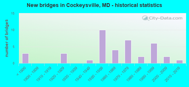
- New bridges - historical statistics
- 3Before 1900
- 31920-1929
- 11940-1949
- 101950-1959
- 41960-1969
- 71970-1979
- 21980-1989
- 61990-1999
- 22000-2009
- 12010-2019
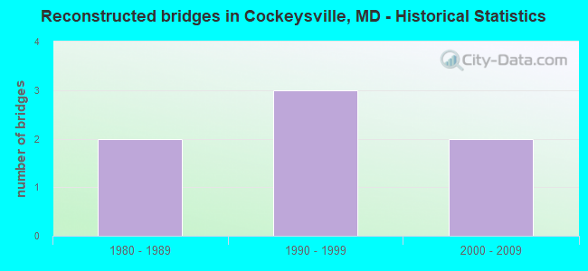
- Reconstructed bridges - Historical Statistics
- 21980-1989
- 31990-1999
- 22000-2009
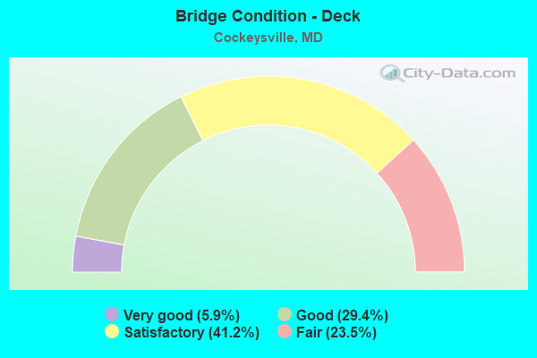
- Bridge Condition - Deck
- 5.9%Very good
- 29.4%Good
- 41.2%Satisfactory
- 23.5%Fair
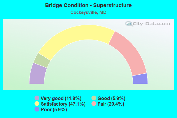
- Bridge Condition - Superstructure
- 11.8%Very good
- 5.9%Good
- 47.1%Satisfactory
- 29.4%Fair
- 5.9%Poor
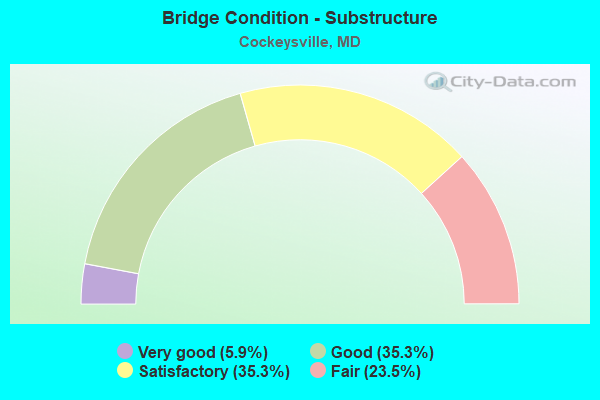
- Bridge Condition - Substructure
- 5.9%Very good
- 35.3%Good
- 35.3%Satisfactory
- 23.5%Fair
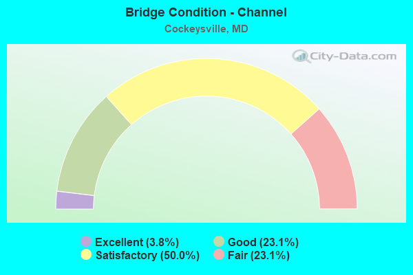
- Bridge Condition - Channel
- 3.8%Excellent
- 23.1%Good
- 50.0%Satisfactory
- 23.1%Fair
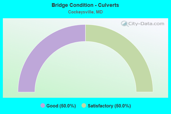
- Bridge Condition - Culverts
- 50.0%Good
- 50.0%Satisfactory
Find on map >> Show street view
Structure Number: 10000003004301, Location: 0.11 M N OF RAILROAD AVE (Lat: 39.485308, Lng: -76.645653), Route carried "on" structure: State highway 45, Year Built: 1990, Status: Open, Structure Length: 4.30m (14.11ft), Average Daily Traffic: 30,482 (year 2009), Truck Traffic: 8%, Average Future Daily Traffic: 33,047 (year 2026), Design Load: HS 20, Features Intersected: BEAVERDAM RUN
Minimum Vertical Clearance: 30+ m (98+ ft), Kilometerpoint: 13.564, Lanes on structure: 5, Base Highway Network: Yes, Owner: State Highway Agency, Approaching Roadway Width: 18.0m (59.1ft), Material/Design: Steel continuous, Design/Construction: Stringer/Multi-beam, Number Of Spans In Main Unit: 3, Length of Maximum Span: 14.0m (45.9ft), Curb or Sidewalk Widths: Left: 1.5m (4.9ft), Right: 1.5m (4.9ft), Curb-To-Curb Width: 17.7m (58.1ft), Out-to-Out Width: 21.7m (71.2ft)
Condition: Deck: Good, Superstructure: Good, Substructure: Good, Channel: Good, Operating Rating: 69.8 metric tons, Method Used To Determine Operating Rating: Load Factor (LF), Inventory Rating: 41.7 metric tons, Method Used To Determine Inventory Rating: Load Factor (LF), Structural Evaluation: Better than present minimum criteria, Deck Geometry: High priority of replacement, Waterway Adequacy: Equal to present desirable criteria, Approach Roadway Alignment: Equal to present desirable criteria, Length Of Structure Improvement: 4.30m (14.11ft), Designated Inspection Frequency: Every 24 months, Inspection Date: July 2021, Bridge Improvement Cost: $603,000, Roadway Improvement Cost: $60,000, Total Project Cost: $663,000, Deck Structure Type: Concrete Cast-file-Place, Wearing Surface/Protective System: Wearing Surface: Monolithic Concrete, Deck Protection: Epoxy Coated Reinforcing
Find on map >> Show street view
Structure Number: 10000003035701, Location: 0.83 MI S OF BEAVERDAM RD (Lat: 39.470306, Lng: -76.662364), Route carried "on" structure: Ramp State highway 83, Year Built: 1991, Status: Open, Structure Length: 11.34m (37.20ft), Average Daily Traffic: 15,300 (year 2006), Truck Traffic: 5%, Average Future Daily Traffic: 17,641 (year 2026), Design Load: HS 25 or greater, Features Intersected: IS 83
Minimum Vertical Clearance: 30+ m (98+ ft), Kilometerpoint: 0.209, Lanes on structure: 1, Lanes under structure: 6, Base Highway Network: Yes, Owner: State Highway Agency, Approaching Roadway Width: 8.2m (26.9ft), Skew: 4 degrees, Material/Design: Steel continuous, Design/Construction: Stringer/Multi-beam, Number Of Spans In Main Unit: 2, Length of Maximum Span: 59.7m (195.9ft), Curb-To-Curb Width: 8.2m (26.9ft), Out-to-Out Width: 9.4m (30.8ft)
Condition: Deck: Good, Superstructure: Very good, Substructure: Good, Inventory Rating: 73.0 metric tons, Method Used To Determine Inventory Rating: Load Factor (LF), Structural Evaluation: Better than present minimum criteria, Deck Geometry: Superior to present desirable criteria, Underclear: Somewhat better than minimum adequacy, Approach Roadway Alignment: Equal to present desirable criteria, Designated Inspection Frequency: Every 24 months, Inspection Date: January 2020, Deck Structure Type: Concrete Cast-file-Place, Wearing Surface/Protective System: Wearing Surface: Monolithic Concrete, Deck Protection: Epoxy Coated Reinforcing
Find on map >> Show street view
Structure Number: 10000003037601, Location: 1.7 MI. E. OF YORK ROAD (Lat: 39.501278, Lng: -76.623686), Route carried "on" structure: State highway 145, Year Built: 2000, Status: Open, Structure Length: 20.54m (67.39ft), Average Daily Traffic: 10,100 (year 2007), Truck Traffic: 6%, Average Future Daily Traffic: 12,800 (year 2027), Design Load: HS 25 or greater, Features Intersected: GUNPOWDER FALLS
Minimum Vertical Clearance: 6.40m (21.00ft), Kilometerpoint: 2.845, Lanes on structure: 2, Owner: State Highway Agency, Approaching Roadway Width: 9.8m (32.2ft), Material/Design: Steel, Design/Construction: Arch - Thru, Number Of Spans In Main Unit: 1, Number Of Approach Spans: 7, Length of Maximum Span: 157.9m (518.0ft), Curb or Sidewalk Widths: Left: 0.5m (1.6ft), Right: 0.5m (1.6ft), Curb-To-Curb Width: 11.0m (36.1ft), Out-to-Out Width: 11.9m (39.0ft)
Condition: Deck: Satisfactory, Superstructure: Satisfactory, Substructure: Satisfactory, Channel: Excellent, Operating Rating: 83.9 metric tons, Method Used To Determine Operating Rating: Allowable Stress (AS), Inventory Rating: 50.3 metric tons, Method Used To Determine Inventory Rating: Allowable Stress (AS), Structural Evaluation: Equal to present minimum criteria, Deck Geometry: Meets minimum limits, Waterway Adequacy: Superior to present desirable criteria, Approach Roadway Alignment: Equal to present desirable criteria, Designated Inspection Frequency: Every 24 months, Critical Feature Inspection Frequency: Every 24 months, Inspection Date: March 2020, Critical Feature Inspection Date: March 2020, Deck Structure Type: Concrete Cast-file-Place, Wearing Surface/Protective System: Wearing Surface: Monolithic Concrete, Deck Protection: Epoxy Coated Reinforcing
Find on map >> Show street view
Structure Number: 200000B-001701, Location: 0.5 MI S OF SPARKS RD (Lat: 39.533997, Lng: -76.616600), Route carried "on" structure: County highway 235, Year Built: 1879, Year Reconstructed: 2006, Status: Posted for load, Structure Length: 2.90m (9.51ft), Average Daily Traffic: 2,665 (year 2021), Truck Traffic: 5%, Average Future Daily Traffic: 3,047 (year 2041), Features Intersected: CARROLL BRANCH, Facility Carried by Structure: CARROLL RD
Minimum Vertical Clearance: 4.57m (14.99ft), Kilometerpoint: 4.618, Lanes on structure: 1, Owner: County Highway Agency, Approaching Roadway Width: 4.6m (15.1ft), Material/Design: Aluminum, Iron, Design/Construction: Truss - Thru, Number Of Spans In Main Unit: 1, Length of Maximum Span: 28.0m (91.9ft), Curb-To-Curb Width: 4.4m (14.4ft), Out-to-Out Width: 5.0m (16.4ft)
Condition: Deck: Satisfactory, Superstructure: Fair, Substructure: Fair, Channel: Good, Operating Rating: 38.5 metric tons, Method Used To Determine Operating Rating: Load Factor (LF), Inventory Rating: 23.1 metric tons, Method Used To Determine Inventory Rating: Load Factor (LF), Structural Evaluation: Somewhat better than minimum adequacy, Deck Geometry: High priority of replacement, Waterway Adequacy: Better than present minimum criteria, Approach Roadway Alignment: Equal to present minimum criteria, Designated Inspection Frequency: Every 24 months, Critical Feature Inspection Frequency: Every 12 months, Other Special Inspection Frequency: Every 12 months, Inspection Date: December 2021, Critical Feature Inspection Date: December 2021, Other Special Inspection Date: December 2021, Deck Structure Type: Wood or Timber, Wearing Surface/Protective System: Wearing Surface: Wood or Timber
Find on map >> Show street view
Structure Number: 200000B-001801, Location: 0.5 MI E OF YORK RD (Lat: 39.539822, Lng: -76.639428), Route carried "on" structure: County highway 239, Year Built: 1888, Year Reconstructed: 1990, Status: Posted for load, Structure Length: 5.43m (17.81ft), Average Daily Traffic: 1,100 (year 2013), Truck Traffic: 5%, Average Future Daily Traffic: 2,200 (year 2035), Design Load: H 20, Features Intersected: GUNPOWDER FALLS, Facility Carried by Structure: SPARKS ROAD
Minimum Vertical Clearance: 4.27m (14.01ft), Kilometerpoint: 0.805, Lanes on structure: 1, Owner: County Highway Agency, Approaching Roadway Width: 4.6m (15.1ft), Material/Design: Steel, Design/Construction: Arch - Thru, Number Of Spans In Main Unit: 1, Length of Maximum Span: 53.3m (174.9ft), Curb-To-Curb Width: 4.6m (15.1ft), Out-to-Out Width: 5.0m (16.4ft)
Condition: Deck: Fair, Superstructure: Poor, Substructure: Fair, Channel: Fair, Operating Rating: 38.5 metric tons, Method Used To Determine Operating Rating: Load Factor (LF), Inventory Rating: 23.1 metric tons, Method Used To Determine Inventory Rating: Load Factor (LF), Structural Evaluation: Meets minimum limits, Deck Geometry: High priority of replacement, Waterway Adequacy: Equal to present minimum criteria, Approach Roadway Alignment: Equal to present minimum criteria, Designated Inspection Frequency: Every 24 months, Critical Feature Inspection Frequency: Every 24 months, Other Special Inspection Frequency: Every 12 months, Inspection Date: Febuary 2020, Critical Feature Inspection Date: Febuary 2020, Other Special Inspection Date: March 2021, Deck Structure Type: Open Grating
Find on map >> Show street view
Structure Number: 200000B-001901, Location: 1 MI E OF YORK RD (Lat: 39.549769, Lng: -76.636217), Route carried "on" structure: County highway 237, Year Built: 1976, Year Reconstructed: 1997, Status: Posted for load, Structure Length: 3.23m (10.60ft), Average Daily Traffic: 364 (year 2018), Truck Traffic: 5%, Average Future Daily Traffic: 817 (year 2039), Design Load: H 20, Features Intersected: GUNPOWDER FALLS, Facility Carried by Structure: GLENCOE ROAD
Minimum Vertical Clearance: 30+ m (98+ ft), Kilometerpoint: 3.009, Lanes on structure: 1, Owner: County Highway Agency, Approaching Roadway Width: 6.1m (20.0ft), Material/Design: Steel, Design/Construction: Truss - Thru, Number Of Spans In Main Unit: 1, Length of Maximum Span: 30.8m (101.0ft), Curb-To-Curb Width: 4.1m (13.5ft), Out-to-Out Width: 5.0m (16.4ft)
Condition: Deck: Fair, Superstructure: Fair, Substructure: Fair, Channel: Satisfactory, Operating Rating: 40.4 metric tons, Method Used To Determine Operating Rating: Load Factor (LF), Inventory Rating: 24.0 metric tons, Method Used To Determine Inventory Rating: Load Factor (LF), Structural Evaluation: Somewhat better than minimum adequacy, Deck Geometry: High priority of replacement, Waterway Adequacy: Equal to present minimum criteria, Approach Roadway Alignment: Equal to present minimum criteria, Length Of Structure Improvement: 3.08m (10.10ft), Designated Inspection Frequency: Every 24 months, Critical Feature Inspection Frequency: Every 24 months, Inspection Date: January 2020, Critical Feature Inspection Date: January 2020, Bridge Improvement Cost: $11,000, Roadway Improvement Cost: $4,000, Total Project Cost: $15,000, Deck Structure Type: Steel plate, Wearing Surface/Protective System: Wearing Surface: Other
Find on map >> Show street view
Structure Number: 200000B-002801, Location: 1.3 MI N OF SHAWAN RD (Lat: 39.510586, Lng: -76.676825), Route carried "on" structure: County highway 195, Year Built: 1988, Status: Open, Structure Length: 1.61m (5.28ft), Average Daily Traffic: 2,360 (year 2017), Truck Traffic: 5%, Average Future Daily Traffic: 3,649 (year 2039), Features Intersected: WESTERN RUN, Facility Carried by Structure: WESTERN RUN ROAD
Minimum Vertical Clearance: 30+ m (98+ ft), Kilometerpoint: 2.269, Lanes on structure: 1, Owner: County Highway Agency, Approaching Roadway Width: 4.3m (14.1ft), Material/Design: Steel, Design/Construction: Truss - Thru, Number Of Spans In Main Unit: 1, Length of Maximum Span: 15.5m (50.9ft), Curb-To-Curb Width: 4.1m (13.5ft), Out-to-Out Width: 4.8m (15.7ft)
Condition: Deck: Fair, Superstructure: Satisfactory, Substructure: Good, Channel: Satisfactory, Operating Rating: 44.0 metric tons, Method Used To Determine Operating Rating: Load Factor (LF), Inventory Rating: 26.3 metric tons, Method Used To Determine Inventory Rating: Load Factor (LF), Structural Evaluation: Equal to present minimum criteria, Deck Geometry: High priority of replacement, Waterway Adequacy: Equal to present minimum criteria, Approach Roadway Alignment: High priority of corrective action, Length Of Structure Improvement: 1.55m (5.09ft), Designated Inspection Frequency: Every 24 months, Critical Feature Inspection Frequency: Every 24 months, Inspection Date: July 2021, Critical Feature Inspection Date: July 2021, Bridge Improvement Cost: $26,000, Total Project Cost: $26,000, Deck Structure Type: Steel plate, Wearing Surface/Protective System: Wearing Surface: Other
Find on map >> Show street view
Structure Number: 200000B-002901, Location: 0.3 MI S WESTERN RUN RD (Lat: 39.526286, Lng: -76.715586), Route carried "on" structure: County highway 194, Year Built: 1893, Year Reconstructed: 2011, Status: Posted for load, Structure Length: 3.54m (11.61ft), Average Daily Traffic: 3,082 (year 2014), Truck Traffic: 5%, Average Future Daily Traffic: 3,400 (year 2034), Design Load: HS 15, Features Intersected: WESTERN RUN, Facility Carried by Structure: CUBA ROAD
Minimum Vertical Clearance: 30+ m (98+ ft), Kilometerpoint: 0.676, Lanes on structure: 1, Owner: County Highway Agency, Approaching Roadway Width: 4.6m (15.1ft), Material/Design: Aluminum, Iron, Design/Construction: Truss - Thru, Number Of Spans In Main Unit: 1, Length of Maximum Span: 34.1m (111.9ft), Curb-To-Curb Width: 4.3m (14.1ft), Out-to-Out Width: 4.7m (15.4ft)
Condition: Deck: Satisfactory, Superstructure: Fair, Substructure: Satisfactory, Channel: Good, Operating Rating: 24.9 metric tons, Method Used To Determine Operating Rating: Load Factor (LF), Inventory Rating: 15.0 metric tons, Method Used To Determine Inventory Rating: Load Factor (LF), Structural Evaluation: Meets minimum limits, Deck Geometry: High priority of replacement, Waterway Adequacy: Equal to present desirable criteria, Approach Roadway Alignment: High priority of corrective action, Bridge Posting: Required (Relationship of Operating Rating to Maximum Legal Load: > 39.9% below), Designated Inspection Frequency: Every 12 months, Critical Feature Inspection Frequency: Every 12 months, Inspection Date: August 2021, Critical Feature Inspection Date: August 2021, Deck Structure Type: Wood or Timber
Find on map >> Show street view
Structure Number: 200000B-003201, Location: 0.5 MI N OF BELFAST ROAD (Lat: 39.554528, Lng: -76.664883), Route carried "on" structure: County highway 212, Year Built: 1978, Status: Open, Structure Length: 2.59m (8.50ft), Average Daily Traffic: 1,329 (year 2021), Truck Traffic: 5%, Average Future Daily Traffic: 2,658 (year 2041), Design Load: HS 20, Features Intersected: PINEY CREEK, Facility Carried by Structure: ENSOR MILL ROAD
Minimum Vertical Clearance: 30+ m (98+ ft), Kilometerpoint: 1.110, Lanes on structure: 2, Owner: County Highway Agency, Approaching Roadway Width: 8.5m (27.9ft), Skew: 5 degrees, Material/Design: Steel, Design/Construction: Stringer/Multi-beam, Number Of Spans In Main Unit: 1, Length of Maximum Span: 24.4m (80.1ft), Curb or Sidewalk Widths: Left: 0.3m (1.0ft), Right: 0.3m (1.0ft), Curb-To-Curb Width: 8.5m (27.9ft), Out-to-Out Width: 9.1m (29.9ft)
Condition: Deck: Good, Superstructure: Satisfactory, Substructure: Good, Channel: Satisfactory, Operating Rating: 80.3 metric tons, Method Used To Determine Operating Rating: Load Factor (LF), Inventory Rating: 48.1 metric tons, Method Used To Determine Inventory Rating: Load Factor (LF), Structural Evaluation: Equal to present minimum criteria, Deck Geometry: Somewhat better than minimum adequacy, Waterway Adequacy: Better than present minimum criteria, Approach Roadway Alignment: Equal to present minimum criteria, Designated Inspection Frequency: Every 24 months, Inspection Date: December 2021, Deck Structure Type: Concrete Cast-file-Place, Wearing Surface/Protective System: Wearing Surface: Monolithic Concrete
Find on map >> Show street view
Structure Number: 200000B-009001, Location: 0.1 MI N COCKEYSVILLE RD (Lat: 39.479511, Lng: -76.654792), Route carried "on" structure: County highway 434, Year Built: 1976, Status: Open, Structure Length: 3.51m (11.52ft), Average Daily Traffic: 26,480 (year 2021), Truck Traffic: 5%, Average Future Daily Traffic: 34,640 (year 2040), Design Load: HS 20, Features Intersected: BEAVER DAM RUN, Facility Carried by Structure: BEAVER DAM ROAD
Minimum Vertical Clearance: 30+ m (98+ ft), Kilometerpoint: 3.636, Lanes on structure: 4, Owner: County Highway Agency, Approaching Roadway Width: 14.6m (47.9ft), Skew: 2 degrees, Material/Design: Steel continuous, Design/Construction: Stringer/Multi-beam, Number Of Spans In Main Unit: 2, Length of Maximum Span: 16.8m (55.1ft), Curb or Sidewalk Widths: Left: 1.5m (4.9ft), Right: 1.5m (4.9ft), Curb-To-Curb Width: 14.6m (47.9ft), Out-to-Out Width: 18.3m (60.0ft)
Condition: Deck: Satisfactory, Superstructure: Satisfactory, Substructure: Satisfactory, Channel: Satisfactory, Operating Rating: 66.2 metric tons, Method Used To Determine Operating Rating: Load Factor (LF), Inventory Rating: 39.5 metric tons, Method Used To Determine Inventory Rating: Load Factor (LF), Structural Evaluation: Equal to present minimum criteria, Deck Geometry: High priority of replacement, Waterway Adequacy: Better than present minimum criteria, Approach Roadway Alignment: Better than present minimum criteria, Designated Inspection Frequency: Every 24 months, Inspection Date: July 2021, Bridge Improvement Cost: $21,000, Roadway Improvement Cost: $4,000, Total Project Cost: $25,000, Deck Structure Type: Concrete Cast-file-Place, Wearing Surface/Protective System: Wearing Surface: Monolithic Concrete
Find on map >> Show street view
Structure Number: 200000B-009101, Location: 0.3 MI S OF SHAWAN ROAD (Lat: 39.495231, Lng: -76.681786), Route carried "on" structure: County highway 434, Year Built: 1952, Year Reconstructed: 2002, Status: Posted for load, Structure Length: 1.55m (5.09ft), Average Daily Traffic: 6,911 (year 2021), Truck Traffic: 5%, Average Future Daily Traffic: 10,176 (year 2041), Design Load: H 20, Features Intersected: OREGON BRANCH, Facility Carried by Structure: BEAVER DAM ROAD
Minimum Vertical Clearance: 30+ m (98+ ft), Kilometerpoint: 0.499, Lanes on structure: 2, Owner: County Highway Agency, Approaching Roadway Width: 7.3m (24.0ft), Skew: 2 degrees, Material/Design: Steel, Design/Construction: Stringer/Multi-beam, Number Of Spans In Main Unit: 1, Length of Maximum Span: 13.7m (44.9ft), Curb or Sidewalk Widths: Left: 0.9m (3.0ft), Right: 0.9m (3.0ft), Curb-To-Curb Width: 8.5m (27.9ft), Out-to-Out Width: 11.0m (36.1ft)
Condition: Deck: Satisfactory, Superstructure: Fair, Substructure: Satisfactory, Channel: Satisfactory, Operating Rating: 59.9 metric tons, Method Used To Determine Operating Rating: Load Factor (LF), Inventory Rating: 35.8 metric tons, Method Used To Determine Inventory Rating: Load Factor (LF), Structural Evaluation: Somewhat better than minimum adequacy, Deck Geometry: High priority of replacement, Waterway Adequacy: Equal to present minimum criteria, Approach Roadway Alignment: Equal to present desirable criteria, Designated Inspection Frequency: Every 24 months, Inspection Date: August 2021, Deck Structure Type: Concrete Cast-file-Place, Wearing Surface/Protective System: Wearing Surface: Monolithic Concrete
Find on map >> Show street view
Structure Number: 200000B-013001, Location: 0.7 MI E OF FALLS RD (Lat: 39.494783, Lng: -76.696942), Route carried "on" structure: County highway 438, Year Built: 1920, Year Reconstructed: 1986, Status: Posted for load, Structure Length: 1.07m (3.51ft), Average Daily Traffic: 22,397 (year 2020), Truck Traffic: 5%, Average Future Daily Traffic: 25,098 (year 2042), Features Intersected: TRIBUTARY OF OREGON BRAN, Facility Carried by Structure: SHAWAN ROAD
Minimum Vertical Clearance: 30+ m (98+ ft), Kilometerpoint: 1.046, Lanes on structure: 2, Owner: County Highway Agency, Approaching Roadway Width: 9.1m (29.9ft), Skew: 2 degrees, Material/Design: Concrete, Design/Construction: Slab, Number Of Spans In Main Unit: 2, Length of Maximum Span: 5.2m (17.1ft), Curb-To-Curb Width: 9.1m (29.9ft), Out-to-Out Width: 9.8m (32.2ft)
Condition: Deck: Fair, Superstructure: Fair, Substructure: Satisfactory, Channel: Satisfactory, Operating Rating: 23.1 metric tons, Method Used To Determine Operating Rating: Load Factor (LF), Inventory Rating: 13.6 metric tons, Method Used To Determine Inventory Rating: Load Factor (LF), Structural Evaluation: High priority of replacement, Deck Geometry: High priority of corrective action, Waterway Adequacy: Equal to present minimum criteria, Approach Roadway Alignment: Equal to present minimum criteria, Bridge Posting: Required (Relationship of Operating Rating to Maximum Legal Load: 20.0 - 29.9% below), Length Of Structure Improvement: 1.83m (6.00ft), Designated Inspection Frequency: Every 24 months, Other Special Inspection Frequency: Every 12 months, Inspection Date: January 2020, Other Special Inspection Date: January 2021, Bridge Improvement Cost: $960,000, Roadway Improvement Cost: $96,000, Total Project Cost: $1,056,000, Deck Structure Type: Concrete Cast-file-Place, Wearing Surface/Protective System: Wearing Surface: Bituminous
Find on map >> Show street view
Structure Number: 200000B-019301, Location: 0.4 MI S OF QUAKER BOTTOM (Lat: 39.516117, Lng: -76.657861), Route carried "on" structure: County highway 201, Year Built: 2010, Status: Open, Structure Length: 1.02m (3.35ft), Average Daily Traffic: 276 (year 2018), Truck Traffic: 5%, Average Future Daily Traffic: 337 (year 2038), Design Load: HS 25 or greater, Features Intersected: BRANCH OF WESTERN RUN, Facility Carried by Structure: THORNTON MILL ROAD
Minimum Vertical Clearance: 30+ m (98+ ft), Kilometerpoint: 1.931, Lanes on structure: 2, Owner: County Highway Agency, Approaching Roadway Width: 5.5m (18.0ft), Skew: 2 degrees, Material/Design: Concrete, Design/Construction: Box Beam or Girders - Multiple, Number Of Spans In Main Unit: 1, Length of Maximum Span: 9.1m (29.9ft), Curb-To-Curb Width: 7.6m (24.9ft), Out-to-Out Width: 8.6m (28.2ft)
Condition: Deck: Very good, Superstructure: Very good, Substructure: Very good, Channel: Satisfactory, Operating Rating: 68.0 metric tons, Method Used To Determine Operating Rating: Load Factor (LF), Inventory Rating: 40.8 metric tons, Method Used To Determine Inventory Rating: Load Factor (LF), Structural Evaluation: Equal to present desirable criteria, Deck Geometry: Somewhat better than minimum adequacy, Waterway Adequacy: Superior to present desirable criteria, Approach Roadway Alignment: Equal to present minimum criteria, Designated Inspection Frequency: Every 24 months, Inspection Date: May 2021, Deck Structure Type: Concrete Cast-file-Place, Wearing Surface/Protective System: Wearing Surface: Other, Deck Protection: Epoxy Coated Reinforcing
Find on map >> Show street view
Structure Number: 200000B-019501, Location: 0.29 MI E OF CARROLL ROAD (Lat: 39.554097, Lng: -76.594700), Route carried "on" structure: County highway 216, Year Built: 1922, Status: Open, Structure Length: 0.82m (2.69ft), Average Daily Traffic: 425 (year 2021), Truck Traffic: 5%, Average Future Daily Traffic: 529 (year 2041), Features Intersected: CARROLL BRANCH, Facility Carried by Structure: CORBETT ROAD
Minimum Vertical Clearance: 30+ m (98+ ft), Kilometerpoint: 6.903, Lanes on structure: 1, Owner: County Highway Agency, Approaching Roadway Width: 5.2m (17.1ft), Skew: 4 degrees, Material/Design: Concrete, Design/Construction: Tee Beam, Number Of Spans In Main Unit: 1, Length of Maximum Span: 7.3m (24.0ft), Curb-To-Curb Width: 5.2m (17.1ft), Out-to-Out Width: 6.0m (19.7ft)
Condition: Deck: Good, Superstructure: Satisfactory, Substructure: Satisfactory, Channel: Fair, Operating Rating: 67.1 metric tons, Method Used To Determine Operating Rating: Load Factor (LF), Inventory Rating: 39.9 metric tons, Method Used To Determine Inventory Rating: Load Factor (LF), Structural Evaluation: Equal to present minimum criteria, Deck Geometry: High priority of replacement, Waterway Adequacy: Equal to present minimum criteria, Approach Roadway Alignment: Equal to present desirable criteria, Designated Inspection Frequency: Every 24 months, Inspection Date: December 2021, Deck Structure Type: Concrete Cast-file-Place, Wearing Surface/Protective System: Wearing Surface: Bituminous
Find on map >> Show street view
Structure Number: 200000B-026602, Location: 0.17 MI W OF MD 45 (Lat: 39.481667, Lng: -76.647000), Route carried "on" structure: County highway 422, Year Built: 1949, Status: Open, Structure Length: 0.70m (2.30ft), Average Daily Traffic: 5,918 (year 2021), Truck Traffic: 5%, Average Future Daily Traffic: 9,960 (year 2041), Design Load: HS 20, Features Intersected: TRIBUTARY OF BEAVERDAM R, Facility Carried by Structure: COCKEYSVILLE ROAD
Minimum Vertical Clearance: 30+ m (98+ ft), Kilometerpoint: 0.692, Lanes on structure: 2, Owner: County Highway Agency, Approaching Roadway Width: 12.8m (42.0ft), Material/Design: Concrete, Design/Construction: Culvert, Length of Maximum Span: 6.1m (20.0ft), Curb or Sidewalk Widths: Left: 0.6m (2.0ft), Right: 0.7m (2.3ft), Curb-To-Curb Width: 12.7m (41.7ft), Out-to-Out Width: 14.8m (48.6ft)
Condition: Channel: Satisfactory, Culverts: Satisfactory, Operating Rating: 41.7 metric tons, Method Used To Determine Operating Rating: Load Factor (LF), Inventory Rating: 24.9 metric tons, Method Used To Determine Inventory Rating: Load Factor (LF), Structural Evaluation: Equal to present minimum criteria, Deck Geometry: Somewhat better than minimum adequacy, Waterway Adequacy: Better than present minimum criteria, Approach Roadway Alignment: Equal to present desirable criteria, Designated Inspection Frequency: Every 24 months, Inspection Date: December 2021
Find on map >> Show street view
Structure Number: 200000B-032602, Location: 0.2 MI E. OF IS83,EXIT 24 (Lat: 39.547658, Lng: -76.663431), Route carried "on" structure: County highway 197, Year Built: 1953, Status: Open, Structure Length: 1.33m (4.36ft), Average Daily Traffic: 4,183 (year 2020), Truck Traffic: 10%, Average Future Daily Traffic: 5,104 (year 2040), Design Load: H 20, Features Intersected: PINEY CREEK, Facility Carried by Structure: BELFAST ROAD
Minimum Vertical Clearance: 30+ m (98+ ft), Kilometerpoint: 3.057, Lanes on structure: 2, Owner: County Highway Agency, Approaching Roadway Width: 7.3m (24.0ft), Material/Design: Concrete, Design/Construction: Culvert, Length of Maximum Span: 6.4m (21.0ft), Curb-To-Curb Width: 1.3m (4.3ft), Out-to-Out Width: 1.4m (4.6ft)
Condition: Channel: Satisfactory, Culverts: Satisfactory, Inventory Rating: 58.0 metric tons, Method Used To Determine Inventory Rating: Load Factor (LF), Structural Evaluation: Equal to present minimum criteria, Deck Geometry: High priority of replacement, Waterway Adequacy: Equal to present desirable criteria, Approach Roadway Alignment: Equal to present minimum criteria, Designated Inspection Frequency: Every 24 months, Inspection Date: December 2021
Find on map >> Show street view
Structure Number: 200000B-033102, Location: 0.3 MI W OF MD RTE 45 (Lat: 39.458333, Lng: -76.638889), Route carried "on" structure: County highway 773, Year Built: 1961, Status: Open, Structure Length: 1.10m (3.61ft), Average Daily Traffic: 47,071 (year 2021), Truck Traffic: 5%, Average Future Daily Traffic: 77,131 (year 2041), Design Load: HS 20, Features Intersected: DEEP RUN, Facility Carried by Structure: PADONIA ROAD
Minimum Vertical Clearance: 30+ m (98+ ft), Kilometerpoint: 5.084, Lanes on structure: 6, Owner: County Highway Agency, Approaching Roadway Width: 23.5m (77.1ft), Skew: 24 degrees, Material/Design: Concrete, Design/Construction: Culvert, Number Of Spans In Main Unit: 2, Length of Maximum Span: 3.4m (11.2ft), Curb or Sidewalk Widths: Left: 0.2m (0.7ft), Right: 0.2m (0.7ft)
Condition: Channel: Satisfactory, Culverts: Good, Operating Rating: 72.6 metric tons, Method Used To Determine Operating Rating: Load Factor (LF), Inventory Rating: 43.5 metric tons, Method Used To Determine Inventory Rating: Load Factor (LF), Structural Evaluation: Better than present minimum criteria, Waterway Adequacy: Better than present minimum criteria, Approach Roadway Alignment: Equal to present desirable criteria, Designated Inspection Frequency: Every 24 months, Inspection Date: May 2021
Find on map >> Show street view
Structure Number: 200000B-039001, Location: 0.6 MI W OF IS 83 (Lat: 39.548019, Lng: -76.680397), Route carried "on" structure: County highway 197, Year Built: 1920, Year Reconstructed: 1993, Status: Open, Structure Length: 0.72m (2.36ft), Average Daily Traffic: 2,600 (year 2021), Truck Traffic: 5%, Average Future Daily Traffic: 3,900 (year 2041), Features Intersected: TRIBUTARY OF PINEY CREEK, Facility Carried by Structure: BELFAST ROAD
Minimum Vertical Clearance: 30+ m (98+ ft), Kilometerpoint: 3.057, Lanes on structure: 2, Owner: County Highway Agency, Approaching Roadway Width: 9.8m (32.2ft), Skew: 5 degrees, Material/Design: Prestressed concrete, Design/Construction: Slab, Number Of Spans In Main Unit: 1, Length of Maximum Span: 6.7m (22.0ft), Curb or Sidewalk Widths: Left: 0.3m (1.0ft), Right: 0.3m (1.0ft), Curb-To-Curb Width: 9.8m (32.2ft), Out-to-Out Width: 10.4m (34.1ft)
Condition: Deck: Satisfactory, Superstructure: Satisfactory, Substructure: Good, Channel: Fair, Inventory Rating: 59.0 metric tons, Method Used To Determine Inventory Rating: Load Factor (LF), Structural Evaluation: Equal to present minimum criteria, Deck Geometry: Meets minimum limits, Waterway Adequacy: Equal to present minimum criteria, Approach Roadway Alignment: Equal to present desirable criteria, Designated Inspection Frequency: Every 24 months, Inspection Date: July 2021, Deck Structure Type: Concrete Precast Panels, Wearing Surface/Protective System: Wearing Surface: Bituminous
Find on map >> Show street view
Structure Number: 200000B-039603, Location: 1.90 MI E OF MD RTE 45 (Lat: 39.499519, Lng: -76.606183), Route carried "on" structure: County highway 773, Year Built: 1975, Status: Open, Structure Length: 0.67m (2.20ft), Average Daily Traffic: 13,820 (year 2019), Truck Traffic: 5%, Average Future Daily Traffic: 17,306 (year 2039), Features Intersected: MERRYMAN BRANCH, Facility Carried by Structure: PADONIA ROAD
Minimum Vertical Clearance: 30+ m (98+ ft), Kilometerpoint: 8.608, Lanes on structure: 4, Owner: County Highway Agency, Approaching Roadway Width: 14.6m (47.9ft), Material/Design: Steel, Design/Construction: Culvert, Number Of Spans In Main Unit: 2, Length of Maximum Span: 3.0m (9.8ft), Curb or Sidewalk Widths: Left: 0.0m, Right: 1.2m (3.9ft)
Condition: Channel: Satisfactory, Culverts: Satisfactory, Structural Evaluation: Equal to present minimum criteria, Waterway Adequacy: Equal to present minimum criteria, Approach Roadway Alignment: Equal to present desirable criteria, Designated Inspection Frequency: Every 24 months, Inspection Date: July 2021
Find on map >> Show street view
Structure Number: 200000B-040101, Location: 0.3 MI W OF CARROLL RD (Lat: 39.542225, Lng: -76.618317), Route carried "on" structure: County highway 239, Year Built: 1990, Status: Open, Structure Length: 1.92m (6.30ft), Average Daily Traffic: 2,161 (year 2020), Truck Traffic: 5%, Average Future Daily Traffic: 2,640 (year 2040), Features Intersected: TRIBUTARY OF CARROLL RUN, Facility Carried by Structure: SPARKS ROAD
Minimum Vertical Clearance: 30+ m (98+ ft), Kilometerpoint: 2.848, Lanes on structure: 1, Owner: County Highway Agency, Approaching Roadway Width: 4.6m (15.1ft), Material/Design: Steel, Design/Construction: Truss - Thru, Number Of Spans In Main Unit: 1, Length of Maximum Span: 18.6m (61.0ft), Curb-To-Curb Width: 4.1m (13.5ft), Out-to-Out Width: 5.0m (16.4ft)
Condition: Deck: Satisfactory, Superstructure: Satisfactory, Substructure: Fair, Channel: Satisfactory, Operating Rating: 54.9 metric tons, Method Used To Determine Operating Rating: Load Factor (LF), Inventory Rating: 32.7 metric tons, Method Used To Determine Inventory Rating: Load Factor (LF), Structural Evaluation: Somewhat better than minimum adequacy, Deck Geometry: High priority of replacement, Waterway Adequacy: Better than present minimum criteria, Approach Roadway Alignment: Equal to present minimum criteria, Designated Inspection Frequency: Every 24 months, Critical Feature Inspection Frequency: Every 24 months, Inspection Date: August 2021, Critical Feature Inspection Date: August 2021, Deck Structure Type: Steel plate, Wearing Surface/Protective System: Wearing Surface: Other
Find on map >> Show street view
Structure Number: 200000B-040203, Location: 0.8 MI S. OF SHAWAN ROAD (Lat: 39.498472, Lng: -76.656625), Route carried "on" structure: County highway 429, Year Built: 1966, Status: Open, Structure Length: 1.40m (4.59ft), Average Daily Traffic: 16,490 (year 2017), Truck Traffic: 5%, Average Future Daily Traffic: 20,787 (year 2041), Features Intersected: OREGON BRANCH, Facility Carried by Structure: MCCORMICK ROAD
Minimum Vertical Clearance: 30+ m (98+ ft), Kilometerpoint: 0.467, Lanes on structure: 4, Owner: County Highway Agency, Approaching Roadway Width: 14.6m (47.9ft), Skew: 1 degrees, Material/Design: Steel, Design/Construction: Culvert, Number Of Spans In Main Unit: 3, Length of Maximum Span: 4.0m (13.1ft), Curb or Sidewalk Widths: Left: 1.5m (4.9ft), Right: 1.5m (4.9ft)
Condition: Channel: Fair, Culverts: Good, Structural Evaluation: Better than present minimum criteria, Waterway Adequacy: Equal to present minimum criteria, Approach Roadway Alignment: Equal to present desirable criteria, Designated Inspection Frequency: Every 24 months, Inspection Date: July 2021
Find on map >> Show street view
Structure Number: 200000B-040303, Location: 0.28 MI E OF IS 83 (Lat: 39.487644, Lng: -76.660819), Route carried "on" structure: County highway 430, Year Built: 1966, Status: Open, Structure Length: 1.41m (4.63ft), Average Daily Traffic: 5,083 (year 2020), Truck Traffic: 5%, Average Future Daily Traffic: 7,327 (year 2041), Features Intersected: OREGON BRANCH, Facility Carried by Structure: GILROY ROAD
Minimum Vertical Clearance: 30+ m (98+ ft), Kilometerpoint: 0.177, Lanes on structure: 2, Owner: County Highway Agency, Approaching Roadway Width: 9.1m (29.9ft), Material/Design: Steel, Design/Construction: Culvert, Length of Maximum Span: 4.0m (13.1ft)
Condition: Channel: Fair, Culverts: Good, Operating Rating: 54.4 metric tons, Method Used To Determine Operating Rating: Load Factor (LF), Inventory Rating: 32.7 metric tons, Method Used To Determine Inventory Rating: Load Factor (LF), Structural Evaluation: Better than present minimum criteria, Waterway Adequacy: Better than present minimum criteria, Approach Roadway Alignment: Equal to present desirable criteria, Designated Inspection Frequency: Every 24 months, Inspection Date: January 2020
Find on map >> Show street view
Structure Number: 200000B-042001, Location: 0.3 MI SE OF IVY HILL RD (Lat: 39.477919, Lng: -76.674969), Route carried "on" structure: County highway , Year Built: 1988, Status: Open, Structure Length: 5.67m (18.60ft), Average Daily Traffic: 700 (year 2015), Truck Traffic: 5%, Average Future Daily Traffic: 2,000 (year 2035), Design Load: HS 20, Features Intersected: BEAVERDAM RUN, Facility Carried by Structure: JEROME JAY DRIVE
Minimum Vertical Clearance: 30+ m (98+ ft), Kilometerpoint: 0.499, Lanes on structure: 2, Owner: County Highway Agency, Approaching Roadway Width: 7.3m (24.0ft), Material/Design: Steel continuous, Design/Construction: Stringer/Multi-beam, Number Of Spans In Main Unit: 2, Length of Maximum Span: 27.4m (89.9ft), Curb-To-Curb Width: 10.4m (34.1ft), Out-to-Out Width: 11.3m (37.1ft)
Condition: Deck: Good, Superstructure: Satisfactory, Substructure: Good, Channel: Good, Operating Rating: 68.0 metric tons, Method Used To Determine Operating Rating: Load Factor (LF), Inventory Rating: 40.8 metric tons, Method Used To Determine Inventory Rating: Load Factor (LF), Structural Evaluation: Equal to present minimum criteria, Deck Geometry: Equal to present minimum criteria, Waterway Adequacy: Equal to present desirable criteria, Approach Roadway Alignment: Equal to present minimum criteria, Designated Inspection Frequency: Every 24 months, Inspection Date: April 2021, Deck Structure Type: Concrete Cast-file-Place, Wearing Surface/Protective System: Wearing Surface: Monolithic Concrete
Find on map >> Show street view
Structure Number: 200000B-042203, Location: 0.09 MI E OF MD 45 (Lat: 39.471800, Lng: -76.638197), Route carried "on" structure: County highway 421, Year Built: 1965, Status: Open, Structure Length: 1.38m (4.53ft), Average Daily Traffic: 2,200 (year 2021), Truck Traffic: 5%, Average Future Daily Traffic: 2,672 (year 2041), Features Intersected: TRIBUTARY OF BEAVER DAM, Facility Carried by Structure: SCOTT ADAM ROAD
Minimum Vertical Clearance: 30+ m (98+ ft), Kilometerpoint: 0.145, Lanes on structure: 2, Owner: County Highway Agency, Approaching Roadway Width: 11.0m (36.1ft), Skew: 5 degrees, Material/Design: Steel, Design/Construction: Culvert, Length of Maximum Span: 4.9m (16.1ft)
Condition: Channel: Fair, Culverts: Satisfactory, Operating Rating: 54.4 metric tons, Method Used To Determine Operating Rating: Field evaluation and documented engineering judgment, Inventory Rating: 32.7 metric tons, Method Used To Determine Inventory Rating: Field evaluation and documented engineering judgment, Structural Evaluation: Equal to present minimum criteria, Waterway Adequacy: Equal to present minimum criteria, Approach Roadway Alignment: Equal to present desirable criteria, Designated Inspection Frequency: Every 24 months, Inspection Date: December 2021
Find on map >> Show street view
Structure Number: 200000B-044102, Location: 0.5 MI. NE OF SR 45 (Lat: 39.514944, Lng: -76.636628), Route carried "on" structure: County highway , Year Built: 2002, Status: Open, Structure Length: 1.01m (3.31ft), Average Daily Traffic: 1,561 (year 2021), Truck Traffic: 5%, Average Future Daily Traffic: 2,081 (year 2041), Design Load: HS 20, Features Intersected: TRIB TO GUNPOWDER FALLS, Facility Carried by Structure: PHOENIX ROAD
Minimum Vertical Clearance: 30+ m (98+ ft), Kilometerpoint: 0.000, Lanes on structure: 2, Owner: County Highway Agency, Approaching Roadway Width: 9.8m (32.2ft), Material/Design: Concrete, Design/Construction: Culvert, Length of Maximum Span: 4.6m (15.1ft), Curb-To-Curb Width: 9.8m (32.2ft), Out-to-Out Width: 10.4m (34.1ft)
Condition: Channel: Good, Culverts: Good, Inventory Rating: 64.4 metric tons, Method Used To Determine Inventory Rating: Load Factor (LF), Structural Evaluation: Better than present minimum criteria, Deck Geometry: Somewhat better than minimum adequacy, Waterway Adequacy: Better than present minimum criteria, Approach Roadway Alignment: Equal to present desirable criteria, Designated Inspection Frequency: Every 24 months, Inspection Date: November 2021, Wearing Surface/Protective System: Wearing Surface: Monolithic Concrete, Deck Protection: Epoxy Coated Reinforcing
Find on map >> Show street view
Structure Number: 200000B-051102, Location: 0.30 MI. N OF PADONIA RD. (Lat: 39.457867, Lng: -77.071989), Route carried "on" structure: County highway , Year Built: 1997, Status: Open, Structure Length: 2.80m (9.19ft), Average Daily Traffic: 10,960 (year 2022), Truck Traffic: 10%, Average Future Daily Traffic: 13,373 (year 2042), Features Intersected: GOODWIN RUN, Facility Carried by Structure: BEAVER DAM ROAD
Minimum Vertical Clearance: 30+ m (98+ ft), Kilometerpoint: 4.393, Lanes on structure: 4, Owner: County Highway Agency, Approaching Roadway Width: 15.2m (49.9ft), Skew: 4 degrees, Material/Design: Concrete, Design/Construction: Culvert, Number Of Spans In Main Unit: 3, Length of Maximum Span: 8.5m (27.9ft), Curb or Sidewalk Widths: Left: 1.4m (4.6ft), Right: 1.5m (4.9ft)
Condition: Channel: Satisfactory, Culverts: Satisfactory, Inventory Rating: 87.1 metric tons, Method Used To Determine Inventory Rating: Load Factor (LF), Structural Evaluation: Equal to present minimum criteria, Waterway Adequacy: Better than present minimum criteria, Approach Roadway Alignment: Equal to present desirable criteria, Designated Inspection Frequency: Every 24 months, Inspection Date: January 2022
Find on map >> Show street view
Structure Number: 200000B-077703, Location: 0.3 Mi. West of MD 45 (Lat: 39.795164, Lng: -77.081589), Route carried "on" structure: County highway 92875, Year Built: 1990, Status: Open, Structure Length: 2.55m (8.37ft), Average Daily Traffic: 17,400 (year 2018), Truck Traffic: 5%, Average Future Daily Traffic: 20,000 (year 2035), Design Load: HS 20, Features Intersected: PARKS RUN, Facility Carried by Structure: WARREN ROAD
Minimum Vertical Clearance: 30+ m (98+ ft), Kilometerpoint: 0.000, Lanes on structure: 4, Owner: County Highway Agency, Approaching Roadway Width: 18.9m (62.0ft), Skew: 4 degrees, Material/Design: Steel, Design/Construction: Culvert, Length of Maximum Span: 7.3m (24.0ft)
Condition: Channel: Good, Culverts: Good, Structural Evaluation: Better than present minimum criteria, Waterway Adequacy: Better than present minimum criteria, Approach Roadway Alignment: Equal to present desirable criteria, Designated Inspection Frequency: Every 24 months, Inspection Date: January 2020
Find on map >> Show street view
Structure Number: 10000003005201, Location: 2.2 MILES SOUTH OF MD 137 (Lat: 39.563786, Lng: -76.665281), Route carried "under" structure: Interstate 83, Year Built: 1955, Structure Length: 0. m, Average Daily Traffic: 64,381 (year 2009), Features Intersected: IS 83, Facility Carried by Structure: COLD BOTTOM RD
Minimum Vertical Clearance: 4.57m (14.99ft), Kilometerpoint: 24.714, Lanes on structure: 2, Lanes under structure: 4, Material/Design: Steel, Design/Construction: Stringer/Multi-beam, Length of Maximum Span: 22.6m (74.1ft)
Find on map >> Show street view
Structure Number: 10000003005401, Location: 1.10 MI S OF COLD BOT RD (Lat: 39.547953, Lng: -76.666536), Route carried "under" structure: County highway 197, Year Built: 1955, Structure Length: 0. m, Average Daily Traffic: 4,851 (year 2009), Features Intersected: BELFAST ROAD, Facility Carried by Structure: IS 83
Minimum Vertical Clearance: 5.18m (16.99ft), Kilometerpoint: 1.770, Lanes on structure: 6, Lanes under structure: 2, Material/Design: Steel, Design/Construction: Stringer/Multi-beam, Length of Maximum Span: 14.6m (47.9ft)
Find on map >> Show street view
Structure Number: 100000030055011, Location: AT IS 83 (Lat: 39.533817, Lng: -76.664067), Route carried "under" structure: County highway 208, Year Built: 1953, Structure Length: 0. m, Features Intersected: QUAKER BOTTOM ROAD, Facility Carried by Structure: IS 83 NBR
Minimum Vertical Clearance: 4.88m (16.01ft), Kilometerpoint: 0.788, Lanes on structure: 2, Lanes under structure: 2, Material/Design: Steel, Design/Construction: Stringer/Multi-beam, Length of Maximum Span: 15.2m (49.9ft)
Find on map >> Show street view
Structure Number: 100000030055012, Location: AT IS 83 (Lat: 39.533917, Lng: -76.664564), Route carried "under" structure: County highway 208, Year Built: 1959, Structure Length: 0. m, Features Intersected: QUAKER BOTTOM ROAD, Facility Carried by Structure: IS 83 SBR
Minimum Vertical Clearance: 6.10m (20.01ft), Kilometerpoint: 0.772, Lanes on structure: 2, Lanes under structure: 2, Material/Design: Steel, Design/Construction: Stringer/Multi-beam, Length of Maximum Span: 15.2m (49.9ft)
Find on map >> Show street view
Structure Number: 100000030056011, Location: AT IS 83 (Lat: 39.521331, Lng: -76.661031), Route carried "under" structure: County highway 201, Year Built: 1953, Structure Length: 0. m, Features Intersected: THORNTON MILL ROAD, Facility Carried by Structure: IS 83 NBR
Minimum Vertical Clearance: 4.88m (16.01ft), Kilometerpoint: 2.928, Lanes on structure: 2, Lanes under structure: 2, Material/Design: Steel continuous, Design/Construction: Stringer/Multi-beam, Length of Maximum Span: 12.8m (42.0ft)
Find on map >> Show street view
Structure Number: 100000030056012, Location: AT IS 83 (Lat: 39.521611, Lng: -76.661397), Route carried "under" structure: County highway 201, Year Built: 1959, Structure Length: 0. m, Features Intersected: THORNTON MILL ROAD, Facility Carried by Structure: IS 83 SBR
Minimum Vertical Clearance: 5.49m (18.01ft), Kilometerpoint: 2.961, Lanes on structure: 2, Lanes under structure: 2, Material/Design: Steel, Design/Construction: Stringer/Multi-beam, Length of Maximum Span: 12.8m (42.0ft)
Find on map >> Show street view
Structure Number: 100000030058011, Location: AT IS 83 (Lat: 39.494717, Lng: -76.667094), Route carried "under" structure: County highway 438, Year Built: 1953, Structure Length: 0. m, Average Daily Traffic: 21,742 (year 2009), Features Intersected: SHAWAN ROAD EBR, Facility Carried by Structure: IS 83 NBR
Minimum Vertical Clearance: 5.49m (18.01ft), Kilometerpoint: 3.685, Lanes on structure: 3, Lanes under structure: 2, Material/Design: Prestressed concrete, Design/Construction: Stringer/Multi-beam, Length of Maximum Span: 30.5m (100.1ft)
Find on map >> Show street view
Structure Number: 100000030058012, Location: AT IS 83 (Lat: 39.495258, Lng: -76.667489), Route carried "under" structure: County highway 438, Year Built: 1959, Structure Length: 0. m, Average Daily Traffic: 21,742 (year 2009), Features Intersected: SHAWAN ROAD EBR, Facility Carried by Structure: IS 83 SBR
Minimum Vertical Clearance: 5.49m (18.01ft), Kilometerpoint: 3.669, Lanes on structure: 3, Lanes under structure: 2, Material/Design: Steel, Design/Construction: Stringer/Multi-beam, Length of Maximum Span: 30.5m (100.1ft)
Find on map >> Show street view
Structure Number: 10000003006001, Location: 1.21 MI N OF WARREN RD (Lat: 39.481969, Lng: -76.664653), Route carried "under" structure: Interstate 83, Year Built: 1973, Structure Length: 0. m, Average Daily Traffic: 85,051 (year 2009), Features Intersected: IS 83, Facility Carried by Structure: BEAVERDAM ROAD
Minimum Vertical Clearance: 4.88m (16.01ft), Kilometerpoint: 15.398, Lanes on structure: 4, Lanes under structure: 6, Material/Design: Steel, Design/Construction: Stringer/Multi-beam, Length of Maximum Span: 40.8m (133.9ft)
Find on map >> Show street view
Structure Number: 100000030293011, Location: AT IS 83 (Lat: 39.494717, Lng: -76.667094), Route carried "under" structure: County highway 438, Year Built: 1975, Structure Length: 0. m, Average Daily Traffic: 21,742 (year 2009), Features Intersected: SHAWAN ROAD WBR, Facility Carried by Structure: IS 83 NBR
Minimum Vertical Clearance: 5.49m (18.01ft), Kilometerpoint: 3.652, Lanes on structure: 3, Lanes under structure: 2, Material/Design: Steel, Design/Construction: Stringer/Multi-beam, Length of Maximum Span: 30.5m (100.1ft)
Find on map >> Show street view
Structure Number: 100000030293012, Location: AT IS 83 (Lat: 39.495258, Lng: -76.667489), Route carried "under" structure: County highway 438, Year Built: 1975, Structure Length: 0. m, Average Daily Traffic: 21,742 (year 2009), Features Intersected: SHAWAN ROAD WBR, Facility Carried by Structure: IS 83 SBR
Minimum Vertical Clearance: 5.49m (18.01ft), Kilometerpoint: 3.685, Lanes on structure: 3, Lanes under structure: 2, Material/Design: Steel, Design/Construction: Stringer/Multi-beam, Length of Maximum Span: 30.5m (100.1ft)
Find on map >> Show street view
Structure Number: 10000003035701, Location: 1.42 M N OF PADONIA ROAD (Lat: 39.470306, Lng: -76.662364), Route carried "under" structure: Interstate 83, Year Built: 1991, Structure Length: 0. m, Average Daily Traffic: 109,911 (year 2012), Truck Traffic: 8%, Features Intersected: IS 83, Facility Carried by Structure: MD 943 RAMP 7'D'
Minimum Vertical Clearance: 4.88m (16.01ft), Kilometerpoint: 14.069, Lanes on structure: 1, Lanes under structure: 6, Material/Design: Steel continuous, Design/Construction: Stringer/Multi-beam, Length of Maximum Span: 59.7m (195.9ft)