Bridge Statistics for Cocoa, Florida (FL)
Condition, Traffic, Stress, Structural Evaluation, Project Costs
- National Bridge Inventory (NBI) Statistics
- 47Number of bridges
- 1,047ft / 319mTotal length
- $3,706,000Total costs
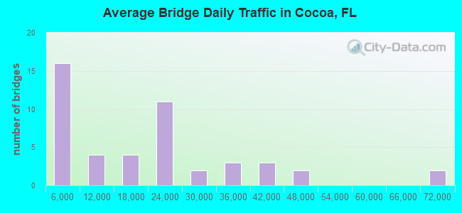
- 859,985Total average daily traffic
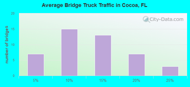
- 108,441Total average daily truck traffic
- National Bridge Inventory (NBI) Registered Bridges for Cocoa
- No street view available for this location
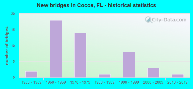
- New bridges - historical statistics
- 21950-1959
- 181960-1969
- 141970-1979
- 11980-1989
- 81990-1999
- 32000-2009
- 12010-2019
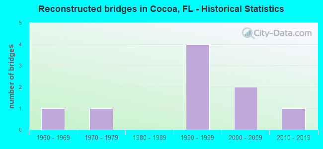
- Reconstructed bridges - Historical Statistics
- 11960-1969
- 11970-1979
- 01980-1989
- 41990-1999
- 22000-2009
- 12010-2019
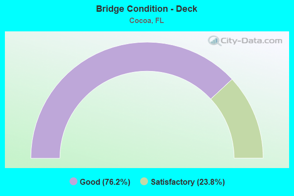
- Bridge Condition - Deck
- 76.2%Good
- 23.8%Satisfactory
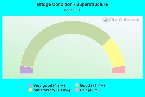
- Bridge Condition - Superstructure
- 4.8%Very good
- 71.4%Good
- 19.0%Satisfactory
- 4.8%Fair
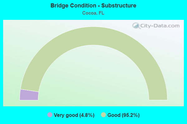
- Bridge Condition - Substructure
- 4.8%Very good
- 95.2%Good
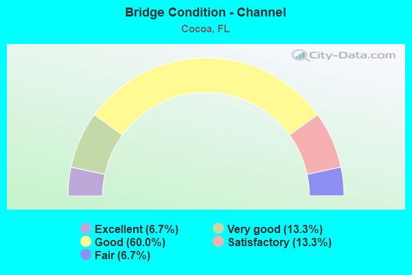
- Bridge Condition - Channel
- 6.7%Excellent
- 13.3%Very good
- 60.0%Good
- 13.3%Satisfactory
- 6.7%Fair
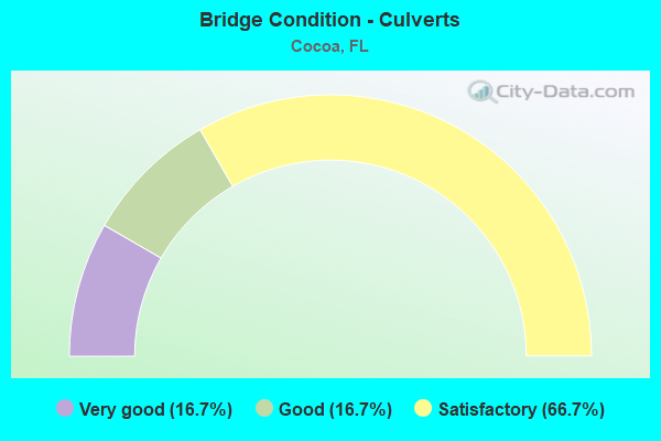
- Bridge Condition - Culverts
- 16.7%Very good
- 16.7%Good
- 66.7%Satisfactory
Find on map >> Show street view
Structure Number: 15004, Location: 0.3MI E OF COLONY POINT (Lat: 26.917128, Lng: -82.086411), Route carried "on" structure: City street , Year Built: 1986, Status: Open, Structure Length: 2.99m (9.81ft), Average Daily Traffic: 4,800 (year 2020), Truck Traffic: 5%, Average Future Daily Traffic: 8,328 (year 2042), Design Load: HS 20, Features Intersected: TARPON INLET, Facility Carried by Structure: WEST MARION AVENUE
Minimum Vertical Clearance: 30+ m (98+ ft), Kilometerpoint: 1.437, Lanes on structure: 2, Owner: City or Municipal Highway Agency, Approaching Roadway Width: 8.5m (27.9ft), Material/Design: Prestressed concrete, Design/Construction: Stringer/Multi-beam, Number Of Spans In Main Unit: 3, Length of Maximum Span: 14.0m (45.9ft), Curb or Sidewalk Widths: Left: 1.7m (5.6ft), Right: 0.0m, Curb-To-Curb Width: 8.5m (27.9ft), Out-to-Out Width: 11.4m (37.4ft)
Condition: Deck: Satisfactory, Superstructure: Good, Substructure: Good, Channel: Excellent, Operating Rating: 49.0 metric tons, Method Used To Determine Operating Rating: Load Factor (LF), Inventory Rating: 29.4 metric tons, Method Used To Determine Inventory Rating: Load Factor (LF), Structural Evaluation: Better than present minimum criteria, Deck Geometry: Meets minimum limits, Waterway Adequacy: Equal to present desirable criteria, Approach Roadway Alignment: Somewhat better than minimum adequacy, Designated Inspection Frequency: Every 24 months, Underwater Inspection Frequency: Every 24 months, Inspection Date: May 2021, Underwater Inspection Date: April 2021, Deck Structure Type: Concrete Cast-file-Place
Find on map >> Show street view
Structure Number: 3016, Location: 7.8MI WEST OF SR 29 (Lat: 26.366536, Lng: -81.484572), Route carried "on" structure: County highway 846, Year Built: 1955, Year Reconstructed: 1977, Status: Open, Structure Length: 3.17m (10.40ft), Average Daily Traffic: 5,777 (year 2021), Truck Traffic: 3%, Average Future Daily Traffic: 6,066 (year 2041), Design Load: H 20, Features Intersected: GATOR CANAL
Minimum Vertical Clearance: 30+ m (98+ ft), Kilometerpoint: 40.927, Lanes on structure: 2, Base Highway Network: Yes, Owner: County Highway Agency, Approaching Roadway Width: 12.2m (40.0ft), Material/Design: Concrete, Design/Construction: Slab, Number Of Spans In Main Unit: 7, Length of Maximum Span: 4.6m (15.1ft), Curb-To-Curb Width: 13.4m (44.0ft), Out-to-Out Width: 14.3m (46.9ft)
Condition: Deck: Good, Superstructure: Good, Substructure: Good, Channel: Good, Operating Rating: 42.1 metric tons, Method Used To Determine Operating Rating: Load Factor (LF), Inventory Rating: 25.1 metric tons, Method Used To Determine Inventory Rating: Load Factor (LF), Structural Evaluation: Equal to present minimum criteria, Deck Geometry: Equal to present minimum criteria, Waterway Adequacy: Better than present minimum criteria, Approach Roadway Alignment: Equal to present desirable criteria, Designated Inspection Frequency: Every 24 months, Underwater Inspection Frequency: Every 24 months, Inspection Date: April 2021, Underwater Inspection Date: March 2021, Deck Structure Type: Concrete Cast-file-Place, Wearing Surface/Protective System: Wearing Surface: Bituminous
Find on map >> Show street view
Structure Number: 700015, Location: SR-528 WB - CR-515 (Lat: 28.401358, Lng: -80.746056), Route carried "on" structure: State highway 528, Year Built: 1963, Year Reconstructed: 2001, Status: Open, Structure Length: 14.28m (46.85ft), Average Daily Traffic: 21,579 (year 2020), Truck Traffic: 8%, Average Future Daily Traffic: 37,439 (year 2042), Design Load: HS 20+Mod, Features Intersected: CR-515 & Indian River
Minimum Vertical Clearance: 30.45m (99.90ft), Kilometerpoint: 9.336, Lanes on structure: 2, Lanes under structure: 2, Base Highway Network: Yes, Owner: State Highway Agency, Approaching Roadway Width: 11.1m (36.4ft), Material/Design: Prestressed concrete, Design/Construction: Stringer/Multi-beam, Number Of Spans In Main Unit: 7, Length of Maximum Span: 21.9m (71.9ft), Curb-To-Curb Width: 9.2m (30.2ft), Out-to-Out Width: 10.3m (33.8ft)
Condition: Deck: Satisfactory, Superstructure: Satisfactory, Substructure: Good, Channel: Good, Operating Rating: 81.6 metric tons, Method Used To Determine Operating Rating: Load Factor (LF), Inventory Rating: 50.3 metric tons, Method Used To Determine Inventory Rating: Load Factor (LF), Structural Evaluation: Equal to present minimum criteria, Deck Geometry: Meets minimum limits, Underclear: Somewhat better than minimum adequacy, Waterway Adequacy: Equal to present desirable criteria, Approach Roadway Alignment: Equal to present desirable criteria, Length Of Structure Improvement: 8.70m (28.54ft), Designated Inspection Frequency: Every 24 months, Underwater Inspection Frequency: Every 24 months, Inspection Date: October 2021, Underwater Inspection Date: October 2021, Bridge Improvement Cost: $87,000, Total Project Cost: $203,000, Deck Structure Type: Concrete Cast-file-Place
Find on map >> Show street view
Structure Number: 700052, Location: I-95 SB - SR-520 (Lat: 28.359825, Lng: -80.794839), Route carried "on" structure: Interstate 95, Year Built: 1966, Year Reconstructed: 2004, Status: Open, Structure Length: 6.56m (21.52ft), Average Daily Traffic: 41,250 (year 2020), Truck Traffic: 10%, Average Future Daily Traffic: 71,569 (year 2042), Design Load: HL 93, Features Intersected: SR-520
Minimum Vertical Clearance: 30+ m (98+ ft), Kilometerpoint: 66.759, Lanes on structure: 3, Lanes under structure: 6, Base Highway Network: Yes, Owner: State Highway Agency, Approaching Roadway Width: 19.7m (64.6ft), Skew: 3 degrees, Material/Design: Prestressed concrete, Design/Construction: Stringer/Multi-beam, Number Of Spans In Main Unit: 4, Length of Maximum Span: 20.7m (67.9ft), Curb-To-Curb Width: 19.7m (64.6ft), Out-to-Out Width: 20.6m (67.6ft)
Condition: Deck: Good, Superstructure: Good, Substructure: Good, Operating Rating: 44.7 metric tons, Method Used To Determine Operating Rating: Load and Resistance Factor (LRFR), Inventory Rating: 34.7 metric tons, Method Used To Determine Inventory Rating: Load and Resistance Factor (LRFR), Structural Evaluation: Better than present minimum criteria, Deck Geometry: Superior to present desirable criteria, Underclear: Meets minimum limits, Approach Roadway Alignment: Equal to present desirable criteria, Designated Inspection Frequency: Every 24 months, Inspection Date: January 2021, Deck Structure Type: Concrete Cast-file-Place
Find on map >> Show street view
Structure Number: 700054, Location: I-95 SB - SR-524 (Lat: 28.374408, Lng: -80.804417), Route carried "on" structure: Interstate 95, Year Built: 1966, Year Reconstructed: 2009, Status: Open, Structure Length: 5.73m (18.80ft), Average Daily Traffic: 33,500 (year 2020), Truck Traffic: 16%, Average Future Daily Traffic: 58,122 (year 2042), Design Load: HS 20, Features Intersected: SR-524
Minimum Vertical Clearance: 30+ m (98+ ft), Kilometerpoint: 1.819, Lanes on structure: 3, Lanes under structure: 4, Base Highway Network: Yes, Owner: State Highway Agency, Approaching Roadway Width: 19.5m (64.0ft), Material/Design: Prestressed concrete, Design/Construction: Stringer/Multi-beam, Number Of Spans In Main Unit: 4, Length of Maximum Span: 17.1m (56.1ft), Curb-To-Curb Width: 19.5m (64.0ft), Out-to-Out Width: 20.4m (66.9ft)
Condition: Deck: Satisfactory, Superstructure: Satisfactory, Substructure: Good, Operating Rating: 51.9 metric tons, Method Used To Determine Operating Rating: Load Factor (LF), Inventory Rating: 32.7 metric tons, Method Used To Determine Inventory Rating: Load Factor (LF), Structural Evaluation: Equal to present minimum criteria, Deck Geometry: Superior to present desirable criteria, Underclear: Equal to present minimum criteria, Approach Roadway Alignment: Equal to present desirable criteria, Designated Inspection Frequency: Every 24 months, Inspection Date: January 2021, Deck Structure Type: Concrete Cast-file-Place
Find on map >> Show street view
Structure Number: 700055, Location: 1.5 Miles North of SR-528 (Lat: 28.431844, Lng: -80.820347), Route carried "on" structure: Interstate 95, Year Built: 1964, Status: Open, Structure Length: 0.86m (2.82ft), Average Daily Traffic: 44,500 (year 2020), Truck Traffic: 23%, Average Future Daily Traffic: 77,208 (year 2042), Design Load: HS 20, Features Intersected: Santiago Canal
Minimum Vertical Clearance: 30+ m (98+ ft), Kilometerpoint: 8.554, Lanes on structure: 6, Base Highway Network: Yes, Owner: State Highway Agency, Approaching Roadway Width: 36.3m (119.1ft), Skew: 10 degrees, Material/Design: Concrete, Design/Construction: Culvert, Number Of Spans In Main Unit: 3, Length of Maximum Span: 2.7m (8.9ft)
Condition: Channel: Satisfactory, Culverts: Satisfactory, Operating Rating: 65.3 metric tons, Method Used To Determine Operating Rating: Load Factor (LF), Inventory Rating: 39.2 metric tons, Method Used To Determine Inventory Rating: Load Factor (LF), Structural Evaluation: Equal to present minimum criteria, Waterway Adequacy: Equal to present desirable criteria, Approach Roadway Alignment: Equal to present desirable criteria, Designated Inspection Frequency: Every 24 months, Inspection Date: January 2021
Find on map >> Show street view
Structure Number: 700061, Location: SR 520 WB Indian River (Lat: 28.356689, Lng: -80.718247), Route carried "on" structure: State highway 520, Year Built: 1966, Status: Open, Structure Length: 70.90m (232.61ft), Average Daily Traffic: 28,500 (year 2020), Truck Traffic: 4%, Average Future Daily Traffic: 49,448 (year 2042), Design Load: HS 20, Features Intersected: Indian River
Minimum Vertical Clearance: 30+ m (98+ ft), Kilometerpoint: 0.216, Lanes on structure: 2, Lanes under structure: 1, Base Highway Network: Yes, Owner: State Highway Agency, Approaching Roadway Width: 12.1m (39.7ft), Navigation Control: Yes ( Vertical Clearance: 19.6m (64.3ft), Horizontal Clearance: 27.4m (89.9ft)), Material/Design: Steel continuous, Design/Construction: Stringer/Multi-beam, Number Of Spans In Main Unit: 3, Number Of Approach Spans: 22, Length of Maximum Span: 42.7m (140.1ft), Curb or Sidewalk Widths: Left: 0.4m (1.3ft), Right: 0.4m (1.3ft), Curb-To-Curb Width: 9.1m (29.9ft), Out-to-Out Width: 11.5m (37.7ft)
Condition: Deck: Good, Superstructure: Good, Substructure: Good, Channel: Good, Operating Rating: 57.2 metric tons, Method Used To Determine Operating Rating: Load Factor (LF), Inventory Rating: 34.3 metric tons, Method Used To Determine Inventory Rating: Load Factor (LF), Structural Evaluation: Better than present minimum criteria, Deck Geometry: Meets minimum limits, Underclear: High priority of corrective action, Waterway Adequacy: Equal to present desirable criteria, Approach Roadway Alignment: Equal to present desirable criteria, Designated Inspection Frequency: Every 24 months, Underwater Inspection Frequency: Every 24 months, Inspection Date: October 2020, Underwater Inspection Date: November 2020, Deck Structure Type: Concrete Cast-file-Place, Wearing Surface/Protective System: Wearing Surface: Monolithic Concrete
Find on map >> Show street view
Structure Number: 700086, Location: 2.7 MI WEST OF SR-9 I-95 (Lat: 28.429431, Lng: -80.853706), Route carried "on" structure: Other road 528, Year Built: 1973, Status: Open, Structure Length: 1.42m (4.66ft), Average Daily Traffic: 36,500 (year 2020), Truck Traffic: 12%, Average Future Daily Traffic: 63,328 (year 2042), Design Load: HS 20, Features Intersected: Ryan's Canal
Minimum Vertical Clearance: 30+ m (98+ ft), Kilometerpoint: 5.459, Lanes on structure: 4, Base Highway Network: Yes, Toll: On toll road, Owner: State Toll Authority, Maintenance Responsibility: State Highway Agency, Approaching Roadway Width: 22.0m (72.2ft), Skew: 20 degrees, Material/Design: Concrete, Design/Construction: Culvert, Number Of Spans In Main Unit: 4, Length of Maximum Span: 3.7m (12.1ft)
Condition: Channel: Good, Culverts: Satisfactory, Operating Rating: 74.0 metric tons, Method Used To Determine Operating Rating: Load Factor (LF), Inventory Rating: 44.4 metric tons, Method Used To Determine Inventory Rating: Load Factor (LF), Structural Evaluation: Equal to present minimum criteria, Waterway Adequacy: Better than present minimum criteria, Approach Roadway Alignment: Equal to present desirable criteria, Designated Inspection Frequency: Every 24 months, Underwater Inspection Frequency: Every 24 months, Inspection Date: August 2020, Underwater Inspection Date: August 2020
Find on map >> Show street view
Structure Number: 700087, Location: SR-528 WB over Pine St. (Lat: 28.411683, Lng: -80.826536), Route carried "on" structure: Other road 528, Year Built: 1973, Year Reconstructed: 1997, Status: Open, Structure Length: 3.63m (11.91ft), Average Daily Traffic: 18,250 (year 2020), Truck Traffic: 12%, Average Future Daily Traffic: 31,664 (year 2042), Design Load: HS 20+Mod, Features Intersected: Pine Street
Minimum Vertical Clearance: 30+ m (98+ ft), Kilometerpoint: 8.956, Lanes on structure: 3, Lanes under structure: 2, Base Highway Network: Yes, Toll: On toll road, Owner: State Toll Authority, Maintenance Responsibility: State Highway Agency, Approaching Roadway Width: 14.5m (47.6ft), Material/Design: Prestressed concrete, Design/Construction: Stringer/Multi-beam, Number Of Spans In Main Unit: 3, Length of Maximum Span: 14.6m (47.9ft), Curb-To-Curb Width: 15.9m (52.2ft), Out-to-Out Width: 16.8m (55.1ft)
Condition: Deck: Good, Superstructure: Good, Substructure: Good, Operating Rating: 63.3 metric tons, Method Used To Determine Operating Rating: Load Factor (LF), Inventory Rating: 38.0 metric tons, Method Used To Determine Inventory Rating: Load Factor (LF), Structural Evaluation: Better than present minimum criteria, Deck Geometry: Somewhat better than minimum adequacy, Underclear: Equal to present minimum criteria, Approach Roadway Alignment: Equal to present desirable criteria, Designated Inspection Frequency: Every 24 months, Inspection Date: August 2020, Deck Structure Type: Concrete Cast-file-Place
Find on map >> Show street view
Structure Number: 700089, Location: 0.6 MILE WEST OF US-1 (Lat: 28.401214, Lng: -80.763569), Route carried "on" structure: Other road 528, Year Built: 1973, Status: Open, Structure Length: 6.31m (20.70ft), Average Daily Traffic: 15,050 (year 2020), Truck Traffic: 12%, Average Future Daily Traffic: 26,112 (year 2042), Design Load: HS 20, Features Intersected: SR-524
Minimum Vertical Clearance: 30+ m (98+ ft), Kilometerpoint: 15.265, Lanes on structure: 3, Lanes under structure: 6, Base Highway Network: Yes, Toll: On toll road, Owner: State Toll Authority, Maintenance Responsibility: State Highway Agency, Approaching Roadway Width: 11.0m (36.1ft), Skew: 1 degrees, Material/Design: Prestressed concrete, Design/Construction: Stringer/Multi-beam, Number Of Spans In Main Unit: 4, Length of Maximum Span: 19.5m (64.0ft), Curb-To-Curb Width: 14.6m (47.9ft), Out-to-Out Width: 15.2m (49.9ft)
Condition: Deck: Good, Superstructure: Good, Substructure: Good, Operating Rating: 61.9 metric tons, Method Used To Determine Operating Rating: Load Factor (LF), Inventory Rating: 38.0 metric tons, Method Used To Determine Inventory Rating: Load Factor (LF), Structural Evaluation: Better than present minimum criteria, Deck Geometry: Meets minimum limits, Underclear: Equal to present minimum criteria, Approach Roadway Alignment: Equal to present desirable criteria, Designated Inspection Frequency: Every 24 months, Inspection Date: August 2020, Deck Structure Type: Concrete Cast-file-Place
Find on map >> Show street view
Structure Number: 700108, Location: SR-528 EB - US-1& FECRR (Lat: 28.400217, Lng: -80.752875), Route carried "on" structure: State highway 528, Year Built: 1970, Status: Open, Structure Length: 9.89m (32.45ft), Average Daily Traffic: 20,000 (year 2020), Truck Traffic: 8%, Average Future Daily Traffic: 34,700 (year 2042), Design Load: HS 20, Features Intersected: US-1 & FECRR
Minimum Vertical Clearance: 30+ m (98+ ft), Kilometerpoint: 8.684, Lanes on structure: 3, Lanes under structure: 8, Base Highway Network: Yes, Owner: State Highway Agency, Approaching Roadway Width: 12.5m (41.0ft), Skew: 1 degrees, Material/Design: Prestressed concrete, Design/Construction: Stringer/Multi-beam, Number Of Spans In Main Unit: 5, Length of Maximum Span: 22.9m (75.1ft), Curb-To-Curb Width: 13.7m (44.9ft), Out-to-Out Width: 14.3m (46.9ft)
Condition: Deck: Good, Superstructure: Good, Substructure: Good, Operating Rating: 58.2 metric tons, Method Used To Determine Operating Rating: Load Factor (LF), Inventory Rating: 36.1 metric tons, Method Used To Determine Inventory Rating: Load Factor (LF), Structural Evaluation: Better than present minimum criteria, Deck Geometry: Meets minimum limits, Underclear: High priority of corrective action, Approach Roadway Alignment: Equal to present desirable criteria, Designated Inspection Frequency: Every 24 months, Inspection Date: October 2021, Deck Structure Type: Concrete Cast-file-Place
Find on map >> Show street view
Structure Number: 700109, Location: SR-528 EB over CR-515 (Lat: 28.401189, Lng: -80.745997), Route carried "on" structure: State highway 528, Year Built: 1970, Status: Open, Structure Length: 14.75m (48.39ft), Average Daily Traffic: 21,579 (year 2020), Truck Traffic: 8%, Average Future Daily Traffic: 37,439 (year 2042), Design Load: HS 20, Features Intersected: CR-515 & Indian River
Minimum Vertical Clearance: 30+ m (98+ ft), Kilometerpoint: 9.336, Lanes on structure: 2, Lanes under structure: 2, Base Highway Network: Yes, Owner: State Highway Agency, Approaching Roadway Width: 10.0m (32.8ft), Material/Design: Prestressed concrete, Design/Construction: Stringer/Multi-beam, Number Of Spans In Main Unit: 7, Length of Maximum Span: 24.4m (80.1ft), Curb-To-Curb Width: 10.0m (32.8ft), Out-to-Out Width: 10.8m (35.4ft)
Condition: Deck: Satisfactory, Superstructure: Good, Substructure: Good, Channel: Good, Operating Rating: 72.6 metric tons, Method Used To Determine Operating Rating: Load Factor (LF), Inventory Rating: 46.5 metric tons, Method Used To Determine Inventory Rating: Load Factor (LF), Structural Evaluation: Better than present minimum criteria, Deck Geometry: Meets minimum limits, Underclear: Somewhat better than minimum adequacy, Waterway Adequacy: Equal to present desirable criteria, Approach Roadway Alignment: Equal to present desirable criteria, Designated Inspection Frequency: Every 24 months, Underwater Inspection Frequency: Every 24 months, Inspection Date: October 2021, Underwater Inspection Date: October 2021, Deck Structure Type: Concrete Cast-file-Place
Find on map >> Show street view
Structure Number: 700127, Location: I-95 NB - SR-520 (Lat: 28.359825, Lng: -80.794508), Route carried "on" structure: Interstate 95, Year Built: 1966, Year Reconstructed: 2010, Status: Open, Structure Length: 6.57m (21.56ft), Average Daily Traffic: 41,250 (year 2020), Truck Traffic: 10%, Average Future Daily Traffic: 71,569 (year 2042), Design Load: HL 93, Features Intersected: SR-520
Minimum Vertical Clearance: 30+ m (98+ ft), Kilometerpoint: 66.752, Lanes on structure: 3, Lanes under structure: 6, Base Highway Network: Yes, Owner: State Highway Agency, Approaching Roadway Width: 19.7m (64.6ft), Skew: 3 degrees, Material/Design: Prestressed concrete, Design/Construction: Stringer/Multi-beam, Number Of Spans In Main Unit: 4, Length of Maximum Span: 20.7m (67.9ft), Curb-To-Curb Width: 19.7m (64.6ft), Out-to-Out Width: 20.6m (67.6ft)
Condition: Deck: Good, Superstructure: Good, Substructure: Good, Operating Rating: 44.7 metric tons, Method Used To Determine Operating Rating: Load and Resistance Factor (LRFR), Inventory Rating: 34.7 metric tons, Method Used To Determine Inventory Rating: Load and Resistance Factor (LRFR), Structural Evaluation: Better than present minimum criteria, Deck Geometry: Superior to present desirable criteria, Underclear: Meets minimum limits, Approach Roadway Alignment: Equal to present desirable criteria, Designated Inspection Frequency: Every 24 months, Inspection Date: January 2021, Deck Structure Type: Concrete Cast-file-Place
Find on map >> Show street view
Structure Number: 700128, Location: I-95 NB - SR-524 (Lat: 28.374542, Lng: -80.804156), Route carried "on" structure: Interstate 95, Year Built: 1966, Year Reconstructed: 2009, Status: Open, Structure Length: 5.73m (18.80ft), Average Daily Traffic: 33,500 (year 2020), Truck Traffic: 16%, Average Future Daily Traffic: 58,122 (year 2042), Design Load: HS 20, Features Intersected: SR-524
Minimum Vertical Clearance: 30+ m (98+ ft), Kilometerpoint: 1.819, Lanes on structure: 3, Lanes under structure: 4, Base Highway Network: Yes, Owner: State Highway Agency, Approaching Roadway Width: 19.5m (64.0ft), Material/Design: Prestressed concrete, Design/Construction: Stringer/Multi-beam, Number Of Spans In Main Unit: 4, Length of Maximum Span: 17.1m (56.1ft), Curb-To-Curb Width: 19.5m (64.0ft), Out-to-Out Width: 20.4m (66.9ft)
Condition: Deck: Good, Superstructure: Good, Substructure: Good, Operating Rating: 51.9 metric tons, Method Used To Determine Operating Rating: Load Factor (LF), Inventory Rating: 32.7 metric tons, Method Used To Determine Inventory Rating: Load Factor (LF), Structural Evaluation: Better than present minimum criteria, Deck Geometry: Superior to present desirable criteria, Underclear: Equal to present minimum criteria, Approach Roadway Alignment: Equal to present desirable criteria, Designated Inspection Frequency: Every 24 months, Inspection Date: January 2021, Deck Structure Type: Concrete Cast-file-Place
Find on map >> Show street view
Structure Number: 700129, Location: Citrus Blvd - I-95 (Lat: 28.424839, Lng: -80.820333), Route carried "on" structure: County highway , Year Built: 1965, Status: Open, Structure Length: 6.46m (21.19ft), Average Daily Traffic: 4,100 (year 2020), Truck Traffic: 5%, Average Future Daily Traffic: 7,114 (year 2042), Design Load: H 20, Features Intersected: I-95, Facility Carried by Structure: Citrus Blvd
Minimum Vertical Clearance: 30+ m (98+ ft), Kilometerpoint: 2.902, Lanes on structure: 2, Lanes under structure: 6, Owner: State Highway Agency, Approaching Roadway Width: 7.5m (24.6ft), Material/Design: Prestressed concrete, Design/Construction: Stringer/Multi-beam, Number Of Spans In Main Unit: 4, Length of Maximum Span: 21.2m (69.6ft), Curb-To-Curb Width: 8.5m (27.9ft), Out-to-Out Width: 10.4m (34.1ft)
Condition: Deck: Good, Superstructure: Satisfactory, Substructure: Good, Operating Rating: 67.6 metric tons, Method Used To Determine Operating Rating: Load Factor (LF), Inventory Rating: 41.7 metric tons, Method Used To Determine Inventory Rating: Load Factor (LF), Structural Evaluation: Equal to present minimum criteria, Deck Geometry: Meets minimum limits, Underclear: Meets minimum limits, Approach Roadway Alignment: Equal to present desirable criteria, Length Of Structure Improvement: 6.46m (21.19ft), Designated Inspection Frequency: Every 24 months, Inspection Date: January 2021, Bridge Improvement Cost: $64,000, Total Project Cost: $281,000, Deck Structure Type: Concrete Cast-file-Place
Find on map >> Show street view
Structure Number: 700137, Location: SR 520 EB - Indian River (Lat: 28.356336, Lng: -80.718111), Route carried "on" structure: State highway 520, Year Built: 1969, Status: Open, Structure Length: 70.90m (232.61ft), Average Daily Traffic: 13,750 (year 2020), Truck Traffic: 13%, Average Future Daily Traffic: 23,856 (year 2042), Design Load: HS 20, Features Intersected: Indian River
Minimum Vertical Clearance: 30+ m (98+ ft), Kilometerpoint: 15.112, Lanes on structure: 2, Lanes under structure: 1, Base Highway Network: Yes, Owner: State Highway Agency, Approaching Roadway Width: 12.1m (39.7ft), Navigation Control: Yes ( Vertical Clearance: 19.7m (64.6ft), Horizontal Clearance: 27.4m (89.9ft)), Material/Design: Steel continuous, Design/Construction: Stringer/Multi-beam, Number Of Spans In Main Unit: 3, Number Of Approach Spans: 22, Length of Maximum Span: 51.8m (169.9ft), Curb or Sidewalk Widths: Left: 0.4m (1.3ft), Right: 0.4m (1.3ft), Curb-To-Curb Width: 9.1m (29.9ft), Out-to-Out Width: 11.5m (37.7ft)
Condition: Deck: Satisfactory, Superstructure: Satisfactory, Substructure: Good, Channel: Good, Operating Rating: 65.4 metric tons, Method Used To Determine Operating Rating: Load Factor (LF), Inventory Rating: 39.2 metric tons, Method Used To Determine Inventory Rating: Load Factor (LF), Structural Evaluation: Equal to present minimum criteria, Deck Geometry: Meets minimum limits, Underclear: High priority of corrective action, Waterway Adequacy: Equal to present desirable criteria, Approach Roadway Alignment: Equal to present desirable criteria, Length Of Structure Improvement: 70.84m (232.41ft), Designated Inspection Frequency: Every 24 months, Underwater Inspection Frequency: Every 24 months, Inspection Date: October 2020, Underwater Inspection Date: November 2020, Bridge Improvement Cost: $1,163,000, Total Project Cost: $1,611,000, Deck Structure Type: Concrete Cast-file-Place, Wearing Surface/Protective System: Wearing Surface: Monolithic Concrete
Find on map >> Show street view
Structure Number: 700151, Location: SR-528 EB over Pine St. (Lat: 28.411458, Lng: -80.826536), Route carried "on" structure: Other road 528, Year Built: 1973, Year Reconstructed: 1997, Status: Open, Structure Length: 3.63m (11.91ft), Average Daily Traffic: 18,250 (year 2020), Truck Traffic: 12%, Average Future Daily Traffic: 31,664 (year 2042), Design Load: HS 20+Mod, Features Intersected: Pine Street
Minimum Vertical Clearance: 30+ m (98+ ft), Kilometerpoint: 8.956, Lanes on structure: 3, Lanes under structure: 2, Base Highway Network: Yes, Toll: On toll road, Owner: State Toll Authority, Maintenance Responsibility: State Highway Agency, Approaching Roadway Width: 10.9m (35.8ft), Material/Design: Prestressed concrete, Design/Construction: Stringer/Multi-beam, Number Of Spans In Main Unit: 3, Length of Maximum Span: 14.5m (47.6ft), Curb-To-Curb Width: 14.7m (48.2ft), Out-to-Out Width: 15.6m (51.2ft)
Condition: Deck: Good, Superstructure: Fair, Substructure: Good, Operating Rating: 72.4 metric tons, Method Used To Determine Operating Rating: Load Factor (LF), Inventory Rating: 43.4 metric tons, Method Used To Determine Inventory Rating: Load Factor (LF), Structural Evaluation: Somewhat better than minimum adequacy, Deck Geometry: Meets minimum limits, Underclear: Equal to present minimum criteria, Approach Roadway Alignment: Equal to present desirable criteria, Designated Inspection Frequency: Every 24 months, Inspection Date: August 2020, Deck Structure Type: Concrete Cast-file-Place
Find on map >> Show street view
Structure Number: 700153, Location: 0.6 MILE WEST OF US-1 (Lat: 28.400997, Lng: -80.763572), Route carried "on" structure: Other road 528, Year Built: 1973, Status: Open, Structure Length: 6.31m (20.70ft), Average Daily Traffic: 15,050 (year 2020), Truck Traffic: 12%, Average Future Daily Traffic: 26,112 (year 2042), Design Load: HS 20, Features Intersected: SR-524
Minimum Vertical Clearance: 30+ m (98+ ft), Kilometerpoint: 15.268, Lanes on structure: 2, Lanes under structure: 6, Base Highway Network: Yes, Toll: On toll road, Owner: State Toll Authority, Maintenance Responsibility: State Highway Agency, Approaching Roadway Width: 11.0m (36.1ft), Skew: 1 degrees, Material/Design: Prestressed concrete, Design/Construction: Stringer/Multi-beam, Number Of Spans In Main Unit: 4, Length of Maximum Span: 19.5m (64.0ft), Curb-To-Curb Width: 14.6m (47.9ft), Out-to-Out Width: 15.2m (49.9ft)
Condition: Deck: Good, Superstructure: Good, Substructure: Good, Operating Rating: 61.9 metric tons, Method Used To Determine Operating Rating: Load Factor (LF), Inventory Rating: 38.0 metric tons, Method Used To Determine Inventory Rating: Load Factor (LF), Structural Evaluation: Better than present minimum criteria, Deck Geometry: Superior to present desirable criteria, Underclear: Equal to present minimum criteria, Approach Roadway Alignment: Equal to present desirable criteria, Designated Inspection Frequency: Every 24 months, Inspection Date: August 2020, Deck Structure Type: Concrete Cast-file-Place
Find on map >> Show street view
Structure Number: 70017, Location: 0.5 Mi. E. of US-1 (Lat: 28.356481, Lng: -80.723528), Route carried "on" structure: State highway 520, Year Built: 1966, Status: Open, Structure Length: 0.67m (2.20ft), Average Daily Traffic: 28,500 (year 2020), Truck Traffic: 4%, Average Future Daily Traffic: 49,448 (year 2042), Design Load: HS 20, Features Intersected: Indian River
Minimum Vertical Clearance: 30+ m (98+ ft), Kilometerpoint: 1.088, Lanes on structure: 3, Base Highway Network: Yes, Owner: State Highway Agency, Approaching Roadway Width: 13.8m (45.3ft), Material/Design: Concrete, Design/Construction: Culvert, Number Of Spans In Main Unit: 2, Length of Maximum Span: 3.0m (9.8ft)
Condition: Channel: Fair, Culverts: Good, Operating Rating: 64.5 metric tons, Method Used To Determine Operating Rating: Load Factor (LF), Inventory Rating: 38.6 metric tons, Method Used To Determine Inventory Rating: Load Factor (LF), Structural Evaluation: Better than present minimum criteria, Waterway Adequacy: Equal to present desirable criteria, Approach Roadway Alignment: Equal to present desirable criteria, Designated Inspection Frequency: Every 24 months, Underwater Inspection Frequency: Every 24 months, Inspection Date: March 2020, Underwater Inspection Date: March 2020
Find on map >> Show street view
Structure Number: 700171, Location: 0.5 Mile East of U.S 1 (Lat: 28.355939, Lng: -80.723519), Route carried "on" structure: State highway 520, Year Built: 1957, Year Reconstructed: 1969, Status: Open, Structure Length: 0.69m (2.26ft), Average Daily Traffic: 13,750 (year 2020), Truck Traffic: 13%, Average Future Daily Traffic: 23,856 (year 2042), Design Load: HS 20, Features Intersected: Indian River
Minimum Vertical Clearance: 30+ m (98+ ft), Kilometerpoint: 14.933, Lanes on structure: 2, Owner: State Highway Agency, Approaching Roadway Width: 13.0m (42.7ft), Material/Design: Concrete, Design/Construction: Culvert, Number Of Spans In Main Unit: 2, Length of Maximum Span: 3.0m (9.8ft)
Condition: Channel: Good, Culverts: Satisfactory, Operating Rating: 62.7 metric tons, Method Used To Determine Operating Rating: Load Factor (LF), Inventory Rating: 37.6 metric tons, Method Used To Determine Inventory Rating: Load Factor (LF), Structural Evaluation: Equal to present minimum criteria, Waterway Adequacy: Equal to present desirable criteria, Approach Roadway Alignment: Equal to present desirable criteria, Length Of Structure Improvement: 0.67m (2.20ft), Designated Inspection Frequency: Every 24 months, Underwater Inspection Frequency: Every 24 months, Inspection Date: January 2022, Underwater Inspection Date: January 2022, Bridge Improvement Cost: $12,000, Total Project Cost: $1,611,000
Find on map >> Show street view
Structure Number: 700197, Location: SR-528 WB at I-95 (Lat: 28.411803, Lng: -80.820367), Route carried "on" structure: Other road 528, Year Built: 1997, Status: Open, Structure Length: 7.56m (24.80ft), Average Daily Traffic: 18,250 (year 2020), Truck Traffic: 12%, Average Future Daily Traffic: 31,664 (year 2042), Design Load: HS 20+Mod, Features Intersected: I-95
Minimum Vertical Clearance: 30+ m (98+ ft), Kilometerpoint: 9.540, Lanes on structure: 3, Lanes under structure: 10, Base Highway Network: Yes, Toll: On toll road, Owner: State Toll Authority, Maintenance Responsibility: State Highway Agency, Approaching Roadway Width: 14.8m (48.6ft), Material/Design: Prestressed concrete, Design/Construction: Stringer/Multi-beam, Number Of Spans In Main Unit: 2, Length of Maximum Span: 37.6m (123.4ft), Curb-To-Curb Width: 15.9m (52.2ft), Out-to-Out Width: 16.9m (55.4ft)
Condition: Deck: Good, Superstructure: Good, Substructure: Good, Operating Rating: 79.2 metric tons, Method Used To Determine Operating Rating: Load Factor (LF), Inventory Rating: 47.4 metric tons, Method Used To Determine Inventory Rating: Load Factor (LF), Structural Evaluation: Better than present minimum criteria, Deck Geometry: Somewhat better than minimum adequacy, Underclear: Equal to present minimum criteria, Approach Roadway Alignment: Equal to present desirable criteria, Designated Inspection Frequency: Every 24 months, Inspection Date: August 2020, Deck Structure Type: Concrete Cast-file-Place
Find on map >> Show street view
Structure Number: 700198, Location: SR-528 EB at I-95 (Lat: 28.411581, Lng: -80.820361), Route carried "on" structure: Other road 528, Year Built: 1997, Status: Open, Structure Length: 7.56m (24.80ft), Average Daily Traffic: 18,250 (year 2020), Truck Traffic: 12%, Average Future Daily Traffic: 31,664 (year 2042), Design Load: HS 20+Mod, Features Intersected: I-95
Minimum Vertical Clearance: 30+ m (98+ ft), Kilometerpoint: 9.540, Lanes on structure: 3, Lanes under structure: 10, Base Highway Network: Yes, Toll: On toll road, Owner: State Toll Authority, Maintenance Responsibility: State Highway Agency, Approaching Roadway Width: 14.8m (48.6ft), Material/Design: Prestressed concrete, Design/Construction: Stringer/Multi-beam, Number Of Spans In Main Unit: 2, Length of Maximum Span: 37.6m (123.4ft), Curb-To-Curb Width: 15.9m (52.2ft), Out-to-Out Width: 16.9m (55.4ft)
Condition: Deck: Good, Superstructure: Good, Substructure: Very good, Operating Rating: 79.2 metric tons, Method Used To Determine Operating Rating: Load Factor (LF), Inventory Rating: 47.4 metric tons, Method Used To Determine Inventory Rating: Load Factor (LF), Structural Evaluation: Better than present minimum criteria, Deck Geometry: Somewhat better than minimum adequacy, Underclear: Equal to present minimum criteria, Approach Roadway Alignment: Equal to present desirable criteria, Designated Inspection Frequency: Every 24 months, Inspection Date: August 2020, Deck Structure Type: Concrete Cast-file-Place
Find on map >> Show street view
Structure Number: 700217, Location: SR-520 EB-St. Johns River (Lat: 28.369469, Lng: -80.872906), Route carried "on" structure: State highway 520, Year Built: 2006, Status: Open, Structure Length: 10.86m (35.63ft), Average Daily Traffic: 4,300 (year 2020), Truck Traffic: 11%, Average Future Daily Traffic: 7,460 (year 2042), Design Load: HS 20, Features Intersected: St. Johns River
Minimum Vertical Clearance: 30+ m (98+ ft), Kilometerpoint: 0.000, Lanes on structure: 2, Base Highway Network: Yes, Owner: State Highway Agency, Approaching Roadway Width: 12.2m (40.0ft), Material/Design: Prestressed concrete, Design/Construction: Stringer/Multi-beam, Number Of Spans In Main Unit: 5, Length of Maximum Span: 21.4m (70.2ft), Curb-To-Curb Width: 12.2m (40.0ft), Out-to-Out Width: 13.1m (43.0ft)
Condition: Deck: Good, Superstructure: Very good, Substructure: Good, Channel: Good, Operating Rating: 73.0 metric tons, Method Used To Determine Operating Rating: Load Factor (LF), Inventory Rating: 43.8 metric tons, Method Used To Determine Inventory Rating: Load Factor (LF), Structural Evaluation: Better than present minimum criteria, Deck Geometry: Better than present minimum criteria, Waterway Adequacy: Equal to present desirable criteria, Approach Roadway Alignment: Equal to present desirable criteria, Designated Inspection Frequency: Every 24 months, Underwater Inspection Frequency: Every 24 months, Inspection Date: January 2021, Underwater Inspection Date: January 2021, Deck Structure Type: Concrete Cast-file-Place, Wearing Surface/Protective System: Wearing Surface: Monolithic Concrete
Find on map >> Show street view
Structure Number: 700219, Location: SR-520 WB - Banana River (Lat: 28.357678, Lng: -80.648156), Route carried "on" structure: State highway 520, Year Built: 2006, Status: Open, Structure Length: 25.05m (82.19ft), Average Daily Traffic: 11,000 (year 2020), Truck Traffic: 5%, Average Future Daily Traffic: 19,085 (year 2042), Design Load: HS 20, Features Intersected: Banana River
Minimum Vertical Clearance: 30+ m (98+ ft), Kilometerpoint: 22.199, Lanes on structure: 2, Base Highway Network: Yes, Owner: State Highway Agency, Approaching Roadway Width: 11.6m (38.1ft), Navigation Control: Yes ( Vertical Clearance: 11.0m (36.1ft), Horizontal Clearance: 18.3m (60.0ft)), Material/Design: Prestressed concrete, Design/Construction: Stringer/Multi-beam, Number Of Spans In Main Unit: 8, Length of Maximum Span: 39.6m (129.9ft), Curb or Sidewalk Widths: Left: 1.5m (4.9ft), Right: 0.0m, Curb-To-Curb Width: 12.2m (40.0ft), Out-to-Out Width: 14.9m (48.9ft)
Condition: Deck: Good, Superstructure: Good, Substructure: Good, Channel: Very good, Operating Rating: 72.0 metric tons, Method Used To Determine Operating Rating: Load Factor (LF), Inventory Rating: 43.2 metric tons, Method Used To Determine Inventory Rating: Load Factor (LF), Structural Evaluation: Better than present minimum criteria, Deck Geometry: Better than present minimum criteria, Waterway Adequacy: Superior to present desirable criteria, Approach Roadway Alignment: Equal to present desirable criteria, Designated Inspection Frequency: Every 24 months, Underwater Inspection Frequency: Every 24 months, Inspection Date: September 2020, Underwater Inspection Date: October 2020, Deck Structure Type: Concrete Cast-file-Place, Wearing Surface/Protective System: Wearing Surface: Monolithic Concrete
Find on map >> Show street view
Structure Number: 70022, Location: SR-520 EB - Banana River (Lat: 28.357311, Lng: -80.648117), Route carried "on" structure: State highway 520, Year Built: 2006, Status: Open, Structure Length: 25.05m (82.19ft), Average Daily Traffic: 11,000 (year 2020), Truck Traffic: 5%, Average Future Daily Traffic: 19,085 (year 2042), Design Load: HS 20, Features Intersected: Banana River
Minimum Vertical Clearance: 30+ m (98+ ft), Kilometerpoint: 22.199, Lanes on structure: 2, Base Highway Network: Yes, Owner: State Highway Agency, Approaching Roadway Width: 16.5m (54.1ft), Navigation Control: Yes ( Vertical Clearance: 11.0m (36.1ft), Horizontal Clearance: 18.3m (60.0ft)), Material/Design: Prestressed concrete, Design/Construction: Stringer/Multi-beam, Number Of Spans In Main Unit: 8, Length of Maximum Span: 39.6m (129.9ft), Curb or Sidewalk Widths: Left: 2.4m (7.9ft), Right: 0.0m, Curb-To-Curb Width: 17.1m (56.1ft), Out-to-Out Width: 20.8m (68.2ft)
Condition: Deck: Good, Superstructure: Good, Substructure: Good, Channel: Very good, Operating Rating: 69.8 metric tons, Method Used To Determine Operating Rating: Load Factor (LF), Inventory Rating: 41.8 metric tons, Method Used To Determine Inventory Rating: Load Factor (LF), Structural Evaluation: Better than present minimum criteria, Deck Geometry: Superior to present desirable criteria, Waterway Adequacy: Equal to present desirable criteria, Approach Roadway Alignment: Equal to present desirable criteria, Designated Inspection Frequency: Every 24 months, Underwater Inspection Frequency: Every 24 months, Inspection Date: September 2020, Underwater Inspection Date: October 2020, Deck Structure Type: Concrete Cast-file-Place, Wearing Surface/Protective System: Wearing Surface: Monolithic Concrete
Find on map >> Show street view
Structure Number: 704193, Location: At Pluckebaum Rd (Lat: 28.345606, Lng: -80.779803), Route carried "on" structure: City street , Year Built: 2012, Status: Open, Structure Length: 1.01m (3.31ft), Average Daily Traffic: 100 (year 2018), Truck Traffic: 1%, Average Future Daily Traffic: 200 (year 2040), Design Load: HL 93, Features Intersected: Canal, Facility Carried by Structure: S. Burnett Rd
Minimum Vertical Clearance: 30+ m (98+ ft), Kilometerpoint: 0.161, Lanes on structure: 2, Owner: County Highway Agency, Approaching Roadway Width: 7.3m (24.0ft), Material/Design: Concrete, Design/Construction: Culvert, Number Of Spans In Main Unit: 3, Length of Maximum Span: 3.0m (9.8ft)
Condition: Channel: Good, Culverts: Very good, Operating Rating: 56.8 metric tons, Method Used To Determine Operating Rating: Load and Resistance Factor (LRFR), Inventory Rating: 43.7 metric tons, Method Used To Determine Inventory Rating: Load and Resistance Factor (LRFR), Structural Evaluation: Equal to present desirable criteria, Waterway Adequacy: Equal to present desirable criteria, Approach Roadway Alignment: Equal to present desirable criteria, Designated Inspection Frequency: Every 24 months, Underwater Inspection Frequency: Every 24 months, Inspection Date: December 2020, Underwater Inspection Date: December 2020
Find on map >> Show street view
Structure Number: 7051, Location: 0.1MI E of Riveredge Blvd (Lat: 28.355033, Lng: -80.723375), Route carried "on" structure: City street , Year Built: 1970, Status: Open, Structure Length: 0.63m (2.07ft), Average Daily Traffic: 1,000 (year 2020), Truck Traffic: 5%, Average Future Daily Traffic: 1,735 (year 2042), Design Load: HS 20, Features Intersected: Indian River, Facility Carried by Structure: Harrison Street
Minimum Vertical Clearance: 30+ m (98+ ft), Kilometerpoint: 0.016, Lanes on structure: 2, Owner: City or Municipal Highway Agency, Approaching Roadway Width: 7.3m (24.0ft), Material/Design: Concrete, Design/Construction: Culvert, Number Of Spans In Main Unit: 2, Length of Maximum Span: 3.0m (9.8ft)
Condition: Channel: Satisfactory, Culverts: Satisfactory, Operating Rating: 39.5 metric tons, Method Used To Determine Operating Rating: Load Factor (LF), Inventory Rating: 23.7 metric tons, Method Used To Determine Inventory Rating: Load Factor (LF), Structural Evaluation: Equal to present minimum criteria, Waterway Adequacy: Equal to present minimum criteria, Approach Roadway Alignment: Equal to present desirable criteria, Designated Inspection Frequency: Every 24 months, Underwater Inspection Frequency: Every 24 months, Inspection Date: September 2020, Underwater Inspection Date: September 2020
Find on map >> Show street view
Structure Number: 700015, Location: SR-528 WB - CR-515 (Lat: 28.401358, Lng: -80.746056), Route carried "under" structure: County highway 515, Year Built: 1963, Structure Length: 0. m, Average Daily Traffic: 1,700 (year 2021), Truck Traffic: 1%, Features Intersected: CR-515 & Indian River, Facility Carried by Structure: SR-528 WB
Minimum Vertical Clearance: 4.45m (14.60ft), Kilometerpoint: 0.000, Lanes on structure: 2, Lanes under structure: 2, Material/Design: Prestressed concrete, Design/Construction: Stringer/Multi-beam, Length of Maximum Span: 21.9m (71.9ft)
Find on map >> Show street view
Structure Number: 700052, Location: I-95 SB - SR-520 (Lat: 28.359825, Lng: -80.794839), Route carried "under" structure: State highway 520, Year Built: 1966, Structure Length: 0. m, Average Daily Traffic: 23,500 (year 2020), Truck Traffic: 8%, Features Intersected: SR-520, Facility Carried by Structure: I-95 SB
Minimum Vertical Clearance: 5.12m (16.80ft), Kilometerpoint: 7.838, Lanes on structure: 3, Lanes under structure: 6, Material/Design: Prestressed concrete, Design/Construction: Stringer/Multi-beam, Length of Maximum Span: 20.7m (67.9ft)
Find on map >> Show street view
Structure Number: 700054, Location: I-95 SB - SR-524 (Lat: 28.374408, Lng: -80.804417), Route carried "under" structure: State highway 524, Year Built: 1966, Structure Length: 0. m, Average Daily Traffic: 6,200 (year 2020), Truck Traffic: 16%, Features Intersected: SR-524, Facility Carried by Structure: I-95 SB
Minimum Vertical Clearance: 5.05m (16.57ft), Kilometerpoint: 2.660, Lanes on structure: 3, Lanes under structure: 4, Material/Design: Prestressed concrete, Design/Construction: Stringer/Multi-beam, Length of Maximum Span: 17.1m (56.1ft)
Find on map >> Show street view
Structure Number: 700061, Location: SR 520 WB Indian River (Lat: 28.356689, Lng: -80.718247), Route carried "under" structure: Other road , Year Built: 1966, Structure Length: 0. m, Average Daily Traffic: 25 (year 1998), Features Intersected: Indian River, Facility Carried by Structure: SR-520 WB
Minimum Vertical Clearance: 4.36m (14.30ft), Kilometerpoint: 0.000, Lanes on structure: 2, Lanes under structure: 1, Material/Design: Steel continuous, Design/Construction: Stringer/Multi-beam, Length of Maximum Span: 42.7m (140.1ft)
Find on map >> Show street view
Structure Number: 700087, Location: SR-528 WB over Pine St. (Lat: 28.411683, Lng: -80.826536), Route carried "under" structure: County highway , Year Built: 1973, Structure Length: 0. m, Average Daily Traffic: 4,100 (year 2020), Truck Traffic: 5%, Features Intersected: Pine Street, Facility Carried by Structure: SR-528 WB
Minimum Vertical Clearance: 4.69m (15.39ft), Kilometerpoint: 0.843, Lanes on structure: 3, Lanes under structure: 2, Material/Design: Prestressed concrete, Design/Construction: Stringer/Multi-beam, Length of Maximum Span: 14.6m (47.9ft)
Find on map >> Show street view
Structure Number: 700089, Location: 0.6 MILE WEST OF US-1 (Lat: 28.401214, Lng: -80.763569), Route carried "under" structure: County highway 524, Year Built: 1973, Structure Length: 0. m, Average Daily Traffic: 21,400 (year 2020), Truck Traffic: 16%, Features Intersected: SR-524, Facility Carried by Structure: SR-528 WB
Minimum Vertical Clearance: 4.94m (16.21ft), Kilometerpoint: 0.309, Lanes on structure: 3, Lanes under structure: 6, Material/Design: Prestressed concrete, Design/Construction: Stringer/Multi-beam, Length of Maximum Span: 19.5m (64.0ft)
Find on map >> Show street view
Structure Number: 700108, Location: SR-528 EB - US-1& FECRR (Lat: 28.400217, Lng: -80.752875), Route carried "under" structure: US 1, Year Built: 1970, Structure Length: 0. m, Average Daily Traffic: 34,000 (year 2020), Truck Traffic: 3%, Features Intersected: US-1 & FECRR, Facility Carried by Structure: SR-528 EB
Minimum Vertical Clearance: 7.38m (24.21ft), Kilometerpoint: 39.202, Lanes on structure: 3, Lanes under structure: 8, Material/Design: Prestressed concrete, Design/Construction: Stringer/Multi-beam, Length of Maximum Span: 22.9m (75.1ft)
Find on map >> Show street view
Structure Number: 700109, Location: SR-528 EB over CR-515 (Lat: 28.401189, Lng: -80.745997), Route carried "under" structure: County highway 515, Year Built: 1970, Structure Length: 0. m, Average Daily Traffic: 1,700 (year 2019), Truck Traffic: 1%, Features Intersected: CR-515 & Indian River, Facility Carried by Structure: SR-528 EB
Minimum Vertical Clearance: 4.45m (14.60ft), Kilometerpoint: 0.000, Lanes on structure: 2, Lanes under structure: 2, Material/Design: Prestressed concrete, Design/Construction: Stringer/Multi-beam, Length of Maximum Span: 24.4m (80.1ft)
Find on map >> Show street view
Structure Number: 700127, Location: I-95 NB - SR-520 (Lat: 28.359825, Lng: -80.794508), Route carried "under" structure: State highway 520, Year Built: 1966, Structure Length: 0. m, Average Daily Traffic: 23,500 (year 2020), Truck Traffic: 20%, Features Intersected: SR-520, Facility Carried by Structure: I-95 NB
Minimum Vertical Clearance: 5.03m (16.50ft), Kilometerpoint: 7.862, Lanes on structure: 3, Lanes under structure: 6, Material/Design: Prestressed concrete, Design/Construction: Stringer/Multi-beam, Length of Maximum Span: 20.7m (67.9ft)
Find on map >> Show street view
Structure Number: 700128, Location: I-95 NB - SR-524 (Lat: 28.374542, Lng: -80.804156), Route carried "under" structure: State highway 524, Year Built: 1966, Structure Length: 0. m, Average Daily Traffic: 11,900 (year 2020), Truck Traffic: 13%, Features Intersected: SR-524, Facility Carried by Structure: I-95 NB
Minimum Vertical Clearance: 5.04m (16.54ft), Kilometerpoint: 2.688, Lanes on structure: 3, Lanes under structure: 4, Material/Design: Prestressed concrete, Design/Construction: Stringer/Multi-beam, Length of Maximum Span: 17.1m (56.1ft)
Find on map >> Show street view
Structure Number: 700129, Location: Citrus Blvd - I-95 (Lat: 28.424839, Lng: -80.820333), Route carried "under" structure: Interstate 95, Year Built: 1965, Structure Length: 0. m, Average Daily Traffic: 44,500 (year 2020), Truck Traffic: 23%, Features Intersected: I-95, Facility Carried by Structure: Citrus Blvd
Minimum Vertical Clearance: 4.75m (15.58ft), Kilometerpoint: 7.780, Lanes on structure: 2, Lanes under structure: 6, Material/Design: Prestressed concrete, Design/Construction: Stringer/Multi-beam, Length of Maximum Span: 21.2m (69.6ft)
Find on map >> Show street view
Structure Number: 700137, Location: SR 520 EB - Indian River (Lat: 28.356336, Lng: -80.718111), Route carried "under" structure: ServiceOther road , Year Built: 1969, Structure Length: 0. m, Average Daily Traffic: 25 (year 2002), Features Intersected: Indian River, Facility Carried by Structure: SR-520 EB
Minimum Vertical Clearance: 4.42m (14.50ft), Kilometerpoint: 0.000, Lanes on structure: 2, Lanes under structure: 1, Material/Design: Steel continuous, Design/Construction: Stringer/Multi-beam, Length of Maximum Span: 51.8m (169.9ft)
Find on map >> Show street view
Structure Number: 700151, Location: SR-528 EB over Pine St. (Lat: 28.411458, Lng: -80.826536), Route carried "under" structure: County highway , Year Built: 1973, Structure Length: 0. m, Average Daily Traffic: 4,100 (year 2020), Truck Traffic: 5%, Features Intersected: Pine Street, Facility Carried by Structure: SR-528 EB
Minimum Vertical Clearance: 4.66m (15.29ft), Kilometerpoint: 0.819, Lanes on structure: 3, Lanes under structure: 2, Material/Design: Prestressed concrete, Design/Construction: Stringer/Multi-beam, Length of Maximum Span: 14.5m (47.6ft)
Find on map >> Show street view
Structure Number: 700153, Location: 0.6 MILE WEST OF US-1 (Lat: 28.400997, Lng: -80.763572), Route carried "under" structure: County highway 524, Year Built: 1973, Structure Length: 0. m, Average Daily Traffic: 21,400 (year 2020), Truck Traffic: 16%, Features Intersected: SR-524, Facility Carried by Structure: SR-528 EB
Minimum Vertical Clearance: 4.72m (15.49ft), Kilometerpoint: 0.285, Lanes on structure: 2, Lanes under structure: 6, Material/Design: Prestressed concrete, Design/Construction: Stringer/Multi-beam, Length of Maximum Span: 19.5m (64.0ft)
Find on map >> Show street view
Structure Number: 700197, Location: SR-528 WB at I-95 (Lat: 28.411803, Lng: -80.820367), Route carried "under" structure: Interstate 95, Year Built: 1997, Structure Length: 0. m, Average Daily Traffic: 67,000 (year 2020), Truck Traffic: 16%, Features Intersected: I-95, Facility Carried by Structure: SR-528 WB
Minimum Vertical Clearance: 5.09m (16.70ft), Kilometerpoint: 6.331, Lanes on structure: 3, Lanes under structure: 6, Material/Design: Prestressed concrete, Design/Construction: Stringer/Multi-beam, Length of Maximum Span: 37.6m (123.4ft)
Find on map >> Show street view
Structure Number: 700197, Location: SR-528 WB at I-95 (Lat: 28.411803, Lng: -80.820367), Route carried "under" structure: Ramp Interstate 95, Year Built: 1997, Structure Length: 0. m, Average Daily Traffic: 1,100 (year 2020), Truck Traffic: 5%, Features Intersected: I-95, Facility Carried by Structure: SR-528 WB
Minimum Vertical Clearance: 5.70m (18.70ft), Kilometerpoint: 0.518, Lanes on structure: 3, Lanes under structure: 2, Material/Design: Prestressed concrete, Design/Construction: Stringer/Multi-beam, Length of Maximum Span: 37.6m (123.4ft)
Find on map >> Show street view
Structure Number: 700197, Location: SR-528 WB at I-95 (Lat: 28.411803, Lng: -80.820367), Route carried "under" structure: Ramp Interstate 95, Year Built: 1997, Structure Length: 0. m, Average Daily Traffic: 1,200 (year 2020), Truck Traffic: 5%, Features Intersected: I-95, Facility Carried by Structure: SR-528 WB
Minimum Vertical Clearance: 5.52m (18.11ft), Kilometerpoint: 0.531, Lanes on structure: 3, Lanes under structure: 2, Material/Design: Prestressed concrete, Design/Construction: Stringer/Multi-beam, Length of Maximum Span: 37.6m (123.4ft)
Find on map >> Show street view
Structure Number: 700198, Location: SR-528 EB at I-95 (Lat: 28.411581, Lng: -80.820361), Route carried "under" structure: Ramp Interstate 95, Year Built: 1997, Structure Length: 0. m, Average Daily Traffic: 1,200 (year 2020), Truck Traffic: 5%, Features Intersected: I-95, Facility Carried by Structure: SR-528 EB
Minimum Vertical Clearance: 5.33m (17.49ft), Kilometerpoint: 0.505, Lanes on structure: 3, Lanes under structure: 2, Material/Design: Prestressed concrete, Design/Construction: Stringer/Multi-beam, Length of Maximum Span: 37.6m (123.4ft)
Find on map >> Show street view
Structure Number: 700198, Location: SR-528 EB at I-95 (Lat: 28.411581, Lng: -80.820361), Route carried "under" structure: Ramp Interstate 95, Year Built: 1997, Structure Length: 0. m, Average Daily Traffic: 1,100 (year 2020), Truck Traffic: 5%, Features Intersected: I-95, Facility Carried by Structure: SR-528 EB
Minimum Vertical Clearance: 5.67m (18.60ft), Kilometerpoint: 0.544, Lanes on structure: 3, Lanes under structure: 2, Material/Design: Prestressed concrete, Design/Construction: Stringer/Multi-beam, Length of Maximum Span: 37.6m (123.4ft)
Find on map >> Show street view
Structure Number: 700198, Location: SR-528 EB at I-95 (Lat: 28.411581, Lng: -80.820361), Route carried "under" structure: Interstate 95, Year Built: 1997, Structure Length: 0. m, Average Daily Traffic: 67,000 (year 2020), Truck Traffic: 16%, Features Intersected: I-95, Facility Carried by Structure: SR-528 EB
Minimum Vertical Clearance: 5.21m (17.09ft), Kilometerpoint: 6.313, Lanes on structure: 3, Lanes under structure: 6, Material/Design: Prestressed concrete, Design/Construction: Stringer/Multi-beam, Length of Maximum Span: 37.6m (123.4ft)