Bridge Statistics for Coconut Creek, Florida (FL)
Condition, Traffic, Stress, Structural Evaluation, Project Costs
- National Bridge Inventory (NBI) Statistics
- 24Number of bridges
- 240ft / 72.6mTotal length
- 943,258Total average daily traffic
- 82,350Total average daily truck traffic
- National Bridge Inventory (NBI) Registered Bridges for Coconut Creek
- No street view available for this location
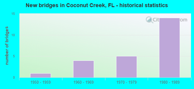
- New bridges - historical statistics
- 11950-1959
- 41960-1969
- 51970-1979
- 141980-1989
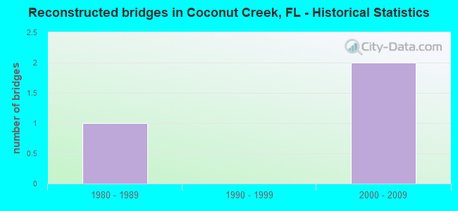
- Reconstructed bridges - Historical Statistics
- 11980-1989
- 01990-1999
- 22000-2009
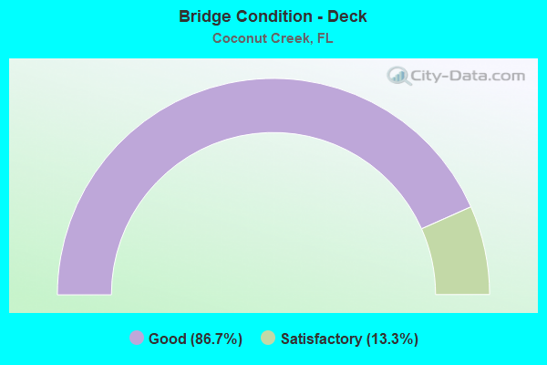
- Bridge Condition - Deck
- 86.7%Good
- 13.3%Satisfactory
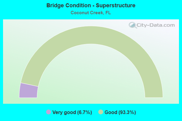
- Bridge Condition - Superstructure
- 6.7%Very good
- 93.3%Good
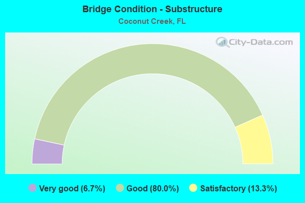
- Bridge Condition - Substructure
- 6.7%Very good
- 80.0%Good
- 13.3%Satisfactory
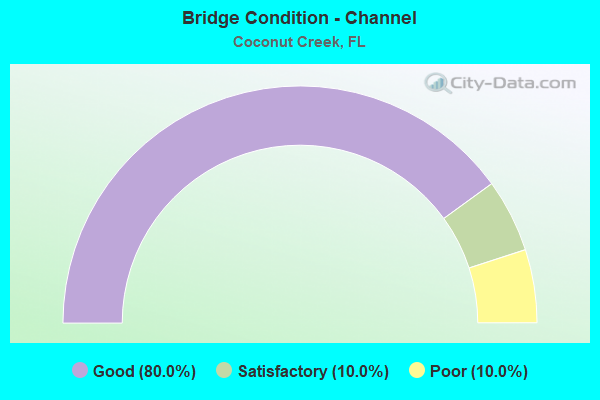
- Bridge Condition - Channel
- 80.0%Good
- 10.0%Satisfactory
- 10.0%Poor
Find on map >> Show street view
Structure Number: 860086, Location: 0.2MI EAST OF LYONS ROAD (Lat: 26.244653, Lng: -80.184572), Route carried "on" structure: County highway , Year Built: 1973, Status: Open, Structure Length: 0.77m (2.53ft), Average Daily Traffic: 27,419 (year 2021), Truck Traffic: 5%, Average Future Daily Traffic: 32,903 (year 2042), Design Load: HS 20, Features Intersected: COCONUT CREEK, Facility Carried by Structure: COCONUT CREEK PKWY
Minimum Vertical Clearance: 30+ m (98+ ft), Kilometerpoint: 1.670, Lanes on structure: 4, Owner: County Highway Agency, Approaching Roadway Width: 17.7m (58.1ft), Material/Design: Concrete, Design/Construction: Slab, Number Of Spans In Main Unit: 1, Length of Maximum Span: 7.7m (25.3ft), Curb or Sidewalk Widths: Left: 1.5m (4.9ft), Right: 1.8m (5.9ft), Curb-To-Curb Width: 17.7m (58.1ft), Out-to-Out Width: 25.1m (82.3ft)
Condition: Deck: Good, Superstructure: Good, Substructure: Good, Channel: Good, Operating Rating: 47.4 metric tons, Method Used To Determine Operating Rating: Load Factor (LF), Inventory Rating: 28.4 metric tons, Method Used To Determine Inventory Rating: Load Factor (LF), Structural Evaluation: Better than present minimum criteria, Deck Geometry: Somewhat better than minimum adequacy, Waterway Adequacy: Equal to present desirable criteria, Approach Roadway Alignment: Equal to present desirable criteria, Designated Inspection Frequency: Every 24 months, Underwater Inspection Frequency: Every 24 months, Inspection Date: May 2021, Underwater Inspection Date: May 2021, Deck Structure Type: Concrete Cast-file-Place
Find on map >> Show street view
Structure Number: 860098, Location: 0.6MI EAST OF LYONS ROAD (Lat: 26.245028, Lng: -80.178028), Route carried "on" structure: County highway , Year Built: 1974, Status: Open, Structure Length: 0.64m (2.10ft), Average Daily Traffic: 27,419 (year 2021), Truck Traffic: 5%, Average Future Daily Traffic: 32,903 (year 2042), Design Load: HS 20+Mod, Features Intersected: COCONUT CREEK, Facility Carried by Structure: COCONUT CREEK PKWY
Minimum Vertical Clearance: 30+ m (98+ ft), Kilometerpoint: 2.297, Lanes on structure: 4, Owner: County Highway Agency, Approaching Roadway Width: 17.0m (55.8ft), Skew: 4 degrees, Material/Design: Concrete, Design/Construction: Culvert, Number Of Spans In Main Unit: 2, Length of Maximum Span: 3.0m (9.8ft)
Condition: Channel: Good, Culverts: Good, Operating Rating: 43.7 metric tons, Method Used To Determine Operating Rating: Load Factor (LF), Inventory Rating: 26.1 metric tons, Method Used To Determine Inventory Rating: Load Factor (LF), Structural Evaluation: Equal to present minimum criteria, Waterway Adequacy: Better than present minimum criteria, Approach Roadway Alignment: Equal to present desirable criteria, Designated Inspection Frequency: Every 24 months, Inspection Date: May 2021
Find on map >> Show street view
Structure Number: 860251, Location: EB Sample Rd / Fla Tpke (Lat: 26.273978, Lng: -80.169372), Route carried "on" structure: State highway 834, Year Built: 1978, Status: Open, Structure Length: 10.04m (32.94ft), Average Daily Traffic: 25,250 (year 2018), Truck Traffic: 5%, Average Future Daily Traffic: 43,809 (year 2040), Design Load: HS 20+Mod, Features Intersected: SR-91 (Fla Turnpike), Facility Carried by Structure: EB Sample Rd
Minimum Vertical Clearance: 30+ m (98+ ft), Kilometerpoint: 8.101, Lanes on structure: 3, Lanes under structure: 8, Base Highway Network: Yes, Owner: State Highway Agency, Approaching Roadway Width: 12.5m (41.0ft), Material/Design: Prestressed concrete, Design/Construction: Stringer/Multi-beam, Number Of Spans In Main Unit: 4, Length of Maximum Span: 26.5m (86.9ft), Curb or Sidewalk Widths: Left: 0.0m, Right: 1.5m (4.9ft), Curb-To-Curb Width: 12.8m (42.0ft), Out-to-Out Width: 15.2m (49.9ft)
Condition: Deck: Satisfactory, Superstructure: Good, Substructure: Satisfactory, Operating Rating: 58.5 metric tons, Method Used To Determine Operating Rating: Load Factor (LF), Inventory Rating: 42.8 metric tons, Method Used To Determine Inventory Rating: Load Factor (LF), Structural Evaluation: Equal to present minimum criteria, Deck Geometry: Meets minimum limits, Underclear: Meets minimum limits, Approach Roadway Alignment: Equal to present desirable criteria, Designated Inspection Frequency: Every 24 months, Inspection Date: May 2021, Deck Structure Type: Concrete Cast-file-Place
Find on map >> Show street view
Structure Number: 860313, Location: Atlantic Blvd W of Turnpk (Lat: 26.231378, Lng: -80.180072), Route carried "on" structure: State highway 814, Year Built: 1983, Year Reconstructed: 1994, Status: Open, Structure Length: 4.57m (14.99ft), Average Daily Traffic: 48,500 (year 2021), Truck Traffic: 6%, Average Future Daily Traffic: 84,148 (year 2042), Design Load: HS 20+Mod, Features Intersected: Coconut Creek, Facility Carried by Structure: Atlantic Blvd.
Minimum Vertical Clearance: 30+ m (98+ ft), Kilometerpoint: 2.504, Lanes on structure: 6, Base Highway Network: Yes, Owner: State Highway Agency, Approaching Roadway Width: 29.9m (98.1ft), Skew: 20 degrees, Material/Design: Prestressed concrete, Design/Construction: Stringer/Multi-beam, Number Of Spans In Main Unit: 3, Length of Maximum Span: 15.2m (49.9ft), Curb or Sidewalk Widths: Left: 1.6m (5.2ft), Right: 2.0m (6.6ft), Curb-To-Curb Width: 29.9m (98.1ft), Out-to-Out Width: 34.4m (112.9ft)
Condition: Deck: Good, Superstructure: Good, Substructure: Good, Channel: Satisfactory, Operating Rating: 43.8 metric tons, Method Used To Determine Operating Rating: Load and Resistance Factor (LRFR), Inventory Rating: 33.6 metric tons, Method Used To Determine Inventory Rating: Load and Resistance Factor (LRFR), Structural Evaluation: Better than present minimum criteria, Deck Geometry: Superior to present desirable criteria, Waterway Adequacy: Superior to present desirable criteria, Approach Roadway Alignment: Equal to present desirable criteria, Designated Inspection Frequency: Every 24 months, Inspection Date: September 2021, Deck Structure Type: Concrete Cast-file-Place
Find on map >> Show street view
Structure Number: 860314, Location: Atlantic Blvd / SR-91 (Lat: 26.231375, Lng: -80.178653), Route carried "on" structure: State highway 814, Year Built: 1983, Status: Open, Structure Length: 14.92m (48.95ft), Average Daily Traffic: 48,500 (year 2021), Truck Traffic: 6%, Average Future Daily Traffic: 84,148 (year 2042), Design Load: HS 20, Features Intersected: SR-91(Florida Turnpike), Facility Carried by Structure: Atlantic Blvd.
Minimum Vertical Clearance: 30+ m (98+ ft), Kilometerpoint: 2.683, Lanes on structure: 6, Lanes under structure: 6, Base Highway Network: Yes, Owner: State Highway Agency, Approaching Roadway Width: 28.2m (92.5ft), Skew: 24 degrees, Material/Design: Prestressed concrete continuous, Design/Construction: Stringer/Multi-beam, Number Of Spans In Main Unit: 2, Number Of Approach Spans: 2, Length of Maximum Span: 56.1m (184.1ft), Curb or Sidewalk Widths: Left: 1.5m (4.9ft), Right: 1.5m (4.9ft), Curb-To-Curb Width: 28.2m (92.5ft), Out-to-Out Width: 32.2m (105.6ft)
Condition: Deck: Good, Superstructure: Good, Substructure: Good, Operating Rating: 53.5 metric tons, Method Used To Determine Operating Rating: Load Factor (LF), Inventory Rating: 32.1 metric tons, Method Used To Determine Inventory Rating: Load Factor (LF), Structural Evaluation: Better than present minimum criteria, Deck Geometry: Superior to present desirable criteria, Underclear: Somewhat better than minimum adequacy, Approach Roadway Alignment: Equal to present desirable criteria, Designated Inspection Frequency: Every 24 months, Inspection Date: September 2021, Deck Structure Type: Concrete Cast-file-Place
Find on map >> Show street view
Structure Number: 860406, Location: WB Sample Rd/ Fla Tpke (Lat: 26.274306, Lng: -80.168533), Route carried "on" structure: State highway 834, Year Built: 1984, Status: Open, Structure Length: 8.61m (28.25ft), Average Daily Traffic: 25,250 (year 2018), Truck Traffic: 5%, Average Future Daily Traffic: 43,809 (year 2040), Design Load: HS 20+Mod, Features Intersected: SR-91 (Fla Turnpike), Facility Carried by Structure: WB Sample Rd
Minimum Vertical Clearance: 30+ m (98+ ft), Kilometerpoint: 8.101, Lanes on structure: 3, Lanes under structure: 8, Base Highway Network: Yes, Owner: State Highway Agency, Approaching Roadway Width: 12.5m (41.0ft), Material/Design: Prestressed concrete, Design/Construction: Stringer/Multi-beam, Number Of Spans In Main Unit: 4, Length of Maximum Span: 26.5m (86.9ft), Curb or Sidewalk Widths: Left: 2.4m (7.9ft), Right: 0.0m, Curb-To-Curb Width: 16.2m (53.1ft), Out-to-Out Width: 17.2m (56.4ft)
Condition: Deck: Good, Superstructure: Good, Substructure: Very good, Operating Rating: 51.4 metric tons, Method Used To Determine Operating Rating: Load Factor (LF), Inventory Rating: 39.9 metric tons, Method Used To Determine Inventory Rating: Load Factor (LF), Structural Evaluation: Better than present minimum criteria, Deck Geometry: Better than present minimum criteria, Underclear: Meets minimum limits, Approach Roadway Alignment: Equal to present desirable criteria, Designated Inspection Frequency: Every 24 months, Inspection Date: May 2021, Deck Structure Type: Concrete Cast-file-Place
Find on map >> Show street view
Structure Number: 860502, Location: 2.1 MILES WEST OF SR-91 (Lat: 26.299872, Lng: -80.202411), Route carried "on" structure: State highway 869, Year Built: 1986, Year Reconstructed: 2007, Status: Open, Structure Length: 6.89m (22.60ft), Average Daily Traffic: 39,600 (year 2020), Truck Traffic: 8%, Average Future Daily Traffic: 68,706 (year 2042), Design Load: HS 20, Features Intersected: US 441-SR 7
Minimum Vertical Clearance: 30+ m (98+ ft), Kilometerpoint: 29.905, Lanes on structure: 4, Lanes under structure: 8, Base Highway Network: Yes, Toll: On toll road, Owner: State Toll Authority, Approaching Roadway Width: 21.6m (70.9ft), Material/Design: Prestressed concrete, Design/Construction: Stringer/Multi-beam, Number Of Spans In Main Unit: 2, Length of Maximum Span: 34.4m (112.9ft), Curb-To-Curb Width: 20.9m (68.6ft), Out-to-Out Width: 21.6m (70.9ft)
Condition: Deck: Good, Superstructure: Good, Substructure: Good, Operating Rating: 78.1 metric tons, Method Used To Determine Operating Rating: Load Factor (LF), Inventory Rating: 46.8 metric tons, Method Used To Determine Inventory Rating: Load Factor (LF), Structural Evaluation: Better than present minimum criteria, Deck Geometry: Better than present minimum criteria, Underclear: Better than present minimum criteria, Approach Roadway Alignment: Equal to present desirable criteria, Designated Inspection Frequency: Every 24 months, Inspection Date: Febuary 2022, Deck Structure Type: Concrete Cast-file-Place
Find on map >> Show street view
Structure Number: 860505, Location: 1.1 MILE WEST OF SR-91 (Lat: 26.301358, Lng: -80.186464), Route carried "on" structure: State highway 869, Year Built: 1986, Year Reconstructed: 2007, Status: Open, Structure Length: 7.72m (25.33ft), Average Daily Traffic: 40,800 (year 2020), Truck Traffic: 8%, Average Future Daily Traffic: 70,788 (year 2042), Design Load: HS 20, Features Intersected: LYONS RD
Minimum Vertical Clearance: 30+ m (98+ ft), Kilometerpoint: 31.532, Lanes on structure: 3, Lanes under structure: 10, Base Highway Network: Yes, Toll: On toll road, Owner: State Toll Authority, Approaching Roadway Width: 18.3m (60.0ft), Skew: 2 degrees, Material/Design: Prestressed concrete, Design/Construction: Stringer/Multi-beam, Number Of Spans In Main Unit: 2, Length of Maximum Span: 38.9m (127.6ft), Curb-To-Curb Width: 17.4m (57.1ft), Out-to-Out Width: 18.0m (59.1ft)
Condition: Deck: Good, Superstructure: Good, Substructure: Good, Inventory Rating: 58.4 metric tons, Method Used To Determine Inventory Rating: Load Factor (LF), Structural Evaluation: Better than present minimum criteria, Deck Geometry: Better than present minimum criteria, Underclear: Meets minimum limits, Approach Roadway Alignment: Equal to present desirable criteria, Designated Inspection Frequency: Every 24 months, Inspection Date: Febuary 2022, Deck Structure Type: Concrete Cast-file-Place
Find on map >> Show street view
Structure Number: 860506, Location: 1 MI N OF SAMPLE RD (Lat: 26.305442, Lng: -80.169464), Route carried "on" structure: State highway 91, Year Built: 1985, Status: Open, Structure Length: 9.39m (30.81ft), Average Daily Traffic: 82,400 (year 2021), Truck Traffic: 13%, Average Future Daily Traffic: 142,964 (year 2042), Design Load: HL 93, Features Intersected: SR 869 SAW
Minimum Vertical Clearance: 30+ m (98+ ft), Kilometerpoint: 39.070, Lanes on structure: 7, Lanes under structure: 8, Base Highway Network: Yes, Toll: On toll road, Owner: State Toll Authority, Approaching Roadway Width: 38.1m (125.0ft), Skew: 30 degrees, Material/Design: Prestressed concrete, Design/Construction: Stringer/Multi-beam, Number Of Spans In Main Unit: 4, Length of Maximum Span: 25.3m (83.0ft), Curb-To-Curb Width: 37.2m (122.0ft), Out-to-Out Width: 38.4m (126.0ft)
Condition: Deck: Satisfactory, Superstructure: Very good, Substructure: Good, Operating Rating: 39.8 metric tons, Method Used To Determine Operating Rating: Load and Resistance Factor (LRFR), Inventory Rating: 34.3 metric tons, Method Used To Determine Inventory Rating: Load and Resistance Factor (LRFR), Structural Evaluation: Better than present minimum criteria, Deck Geometry: Superior to present desirable criteria, Underclear: Equal to present minimum criteria, Approach Roadway Alignment: Equal to present desirable criteria, Designated Inspection Frequency: Every 24 months, Inspection Date: September 2021, Deck Structure Type: Concrete Cast-file-Place
Find on map >> Show street view
Structure Number: 864099, Location: 0.6MI N OF HILLSBORO BLVD (Lat: 26.327828, Lng: -80.186542), Route carried "on" structure: County highway , Year Built: 1989, Status: Open, Structure Length: 4.28m (14.04ft), Average Daily Traffic: 28,559 (year 2021), Truck Traffic: 3%, Average Future Daily Traffic: 49,550 (year 2042), Design Load: HS 20, Features Intersected: HILLSBORO CANAL, Facility Carried by Structure: LYONS ROAD
Minimum Vertical Clearance: 30+ m (98+ ft), Kilometerpoint: 1.120, Lanes on structure: 6, Owner: County Highway Agency, Approaching Roadway Width: 29.2m (95.8ft), Skew: 20 degrees, Material/Design: Concrete continuous, Design/Construction: Slab, Number Of Spans In Main Unit: 5, Length of Maximum Span: 9.3m (30.5ft), Curb or Sidewalk Widths: Left: 1.8m (5.9ft), Right: 1.8m (5.9ft), Curb-To-Curb Width: 29.2m (95.8ft), Out-to-Out Width: 35.1m (115.2ft)
Condition: Deck: Good, Superstructure: Good, Substructure: Good, Channel: Good, Operating Rating: 46.3 metric tons, Method Used To Determine Operating Rating: Allowable Stress (AS), Inventory Rating: 28.1 metric tons, Method Used To Determine Inventory Rating: Allowable Stress (AS), Structural Evaluation: Better than present minimum criteria, Deck Geometry: Superior to present desirable criteria, Waterway Adequacy: Better than present minimum criteria, Approach Roadway Alignment: Equal to present desirable criteria, Designated Inspection Frequency: Every 24 months, Underwater Inspection Frequency: Every 24 months, Inspection Date: October 2021, Underwater Inspection Date: October 2021, Deck Structure Type: Concrete Cast-file-Place
Find on map >> Show street view
Structure Number: 865, Location: 0.1MI S of COCONUT PKWY (Lat: 26.242828, Lng: -80.183972), Route carried "on" structure: City street , Year Built: 1960, Status: Posted for load-capacity, Structure Length: 0.79m (2.59ft), Average Daily Traffic: 3,120 (year 2021), Truck Traffic: 4%, Average Future Daily Traffic: 4,338 (year 2042), Design Load: H 15, Features Intersected: COCONUT CREEK, Facility Carried by Structure: NW 45th AVE.
Minimum Vertical Clearance: 30+ m (98+ ft), Kilometerpoint: 1.030, Lanes on structure: 2, Owner: City or Municipal Highway Agency, Approaching Roadway Width: 7.0m (23.0ft), Material/Design: Prestressed concrete, Design/Construction: Slab, Number Of Spans In Main Unit: 1, Length of Maximum Span: 7.9m (25.9ft), Curb or Sidewalk Widths: Left: 1.1m (3.6ft), Right: 1.1m (3.6ft), Curb-To-Curb Width: 8.5m (27.9ft), Out-to-Out Width: 11.4m (37.4ft)
Condition: Deck: Good, Superstructure: Good, Substructure: Good, Channel: Good, Operating Rating: 46.2 metric tons, Method Used To Determine Operating Rating: Allowable Stress (AS), Inventory Rating: 24.9 metric tons, Method Used To Determine Inventory Rating: Allowable Stress (AS), Structural Evaluation: Equal to present minimum criteria, Deck Geometry: Meets minimum limits, Waterway Adequacy: Equal to present desirable criteria, Approach Roadway Alignment: Equal to present desirable criteria, Designated Inspection Frequency: Every 24 months, Underwater Inspection Frequency: Every 24 months, Inspection Date: August 2021, Underwater Inspection Date: August 2021, Deck Structure Type: Concrete Precast Panels, Wearing Surface/Protective System: Wearing Surface: Bituminous
Find on map >> Show street view
Structure Number: 865001, Location: 150ft E OF NW 43RD AVE. (Lat: 26.238025, Lng: -80.180092), Route carried "on" structure: City street , Year Built: 1963, Status: Open, Structure Length: 0.79m (2.59ft), Average Daily Traffic: 3,120 (year 2021), Truck Traffic: 4%, Average Future Daily Traffic: 4,338 (year 2042), Design Load: H 15, Features Intersected: PALMETTO WATERWAY, Facility Carried by Structure: COCONUT CREEK BLVD
Minimum Vertical Clearance: 30+ m (98+ ft), Kilometerpoint: 0.000, Lanes on structure: 2, Owner: City or Municipal Highway Agency, Approaching Roadway Width: 6.7m (22.0ft), Material/Design: Prestressed concrete, Design/Construction: Slab, Number Of Spans In Main Unit: 1, Length of Maximum Span: 7.9m (25.9ft), Curb or Sidewalk Widths: Left: 1.0m (3.3ft), Right: 1.0m (3.3ft), Curb-To-Curb Width: 8.5m (27.9ft), Out-to-Out Width: 11.3m (37.1ft)
Condition: Deck: Good, Superstructure: Good, Substructure: Good, Channel: Good, Operating Rating: 46.2 metric tons, Method Used To Determine Operating Rating: Allowable Stress (AS), Inventory Rating: 24.9 metric tons, Method Used To Determine Inventory Rating: Allowable Stress (AS), Structural Evaluation: Equal to present minimum criteria, Deck Geometry: Meets minimum limits, Waterway Adequacy: Equal to present desirable criteria, Approach Roadway Alignment: Equal to present desirable criteria, Designated Inspection Frequency: Every 24 months, Underwater Inspection Frequency: Every 24 months, Inspection Date: August 2021, Underwater Inspection Date: August 2021, Deck Structure Type: Concrete Precast Panels, Wearing Surface/Protective System: Wearing Surface: Bituminous
Find on map >> Show street view
Structure Number: 865002, Location: 150FT E of NW 43RD AVE. (Lat: 26.235169, Lng: -80.180439), Route carried "on" structure: City street , Year Built: 1970, Status: Open, Structure Length: 0.79m (2.59ft), Average Daily Traffic: 1,248 (year 2021), Truck Traffic: 4%, Average Future Daily Traffic: 1,735 (year 2042), Design Load: H 15, Features Intersected: PALMETTO WATERWAY, Facility Carried by Structure: NW 3rd COURT
Minimum Vertical Clearance: 30+ m (98+ ft), Kilometerpoint: 0.000, Lanes on structure: 2, Owner: City or Municipal Highway Agency, Approaching Roadway Width: 7.0m (23.0ft), Material/Design: Prestressed concrete, Design/Construction: Slab, Number Of Spans In Main Unit: 1, Length of Maximum Span: 7.9m (25.9ft), Curb or Sidewalk Widths: Left: 1.2m (3.9ft), Right: 1.2m (3.9ft), Curb-To-Curb Width: 8.7m (28.5ft), Out-to-Out Width: 11.6m (38.1ft)
Condition: Deck: Good, Superstructure: Good, Substructure: Good, Channel: Good, Operating Rating: 46.2 metric tons, Method Used To Determine Operating Rating: Allowable Stress (AS), Inventory Rating: 24.9 metric tons, Method Used To Determine Inventory Rating: Allowable Stress (AS), Structural Evaluation: Equal to present minimum criteria, Deck Geometry: Somewhat better than minimum adequacy, Waterway Adequacy: Equal to present desirable criteria, Approach Roadway Alignment: Better than present minimum criteria, Designated Inspection Frequency: Every 24 months, Underwater Inspection Frequency: Every 24 months, Inspection Date: August 2021, Underwater Inspection Date: August 2021, Deck Structure Type: Concrete Precast Panels, Wearing Surface/Protective System: Wearing Surface: Bituminous
Find on map >> Show street view
Structure Number: 865003, Location: 150FT E of LAKE DR. (Lat: 26.233872, Lng: -80.177164), Route carried "on" structure: City street , Year Built: 1969, Status: Open, Structure Length: 0.79m (2.59ft), Average Daily Traffic: 1,373 (year 2021), Truck Traffic: 4%, Average Future Daily Traffic: 1,909 (year 2042), Design Load: H 15, Features Intersected: COCONUT CREEK WATERWAY, Facility Carried by Structure: SUNSHINE WAY
Minimum Vertical Clearance: 30+ m (98+ ft), Kilometerpoint: 0.000, Lanes on structure: 2, Owner: City or Municipal Highway Agency, Approaching Roadway Width: 6.9m (22.6ft), Material/Design: Prestressed concrete, Design/Construction: Slab, Number Of Spans In Main Unit: 1, Length of Maximum Span: 7.9m (25.9ft), Curb or Sidewalk Widths: Left: 1.2m (3.9ft), Right: 1.2m (3.9ft), Curb-To-Curb Width: 8.7m (28.5ft), Out-to-Out Width: 11.6m (38.1ft)
Condition: Deck: Good, Superstructure: Good, Substructure: Good, Channel: Good, Operating Rating: 46.2 metric tons, Method Used To Determine Operating Rating: Allowable Stress (AS), Inventory Rating: 24.9 metric tons, Method Used To Determine Inventory Rating: Allowable Stress (AS), Structural Evaluation: Equal to present minimum criteria, Deck Geometry: Somewhat better than minimum adequacy, Waterway Adequacy: Equal to present desirable criteria, Approach Roadway Alignment: Equal to present desirable criteria, Designated Inspection Frequency: Every 24 months, Underwater Inspection Frequency: Every 24 months, Inspection Date: August 2021, Underwater Inspection Date: August 2021, Deck Structure Type: Concrete Precast Panels, Wearing Surface/Protective System: Wearing Surface: Bituminous
Find on map >> Show street view
Structure Number: 865004, Location: 0.1MI N OF 39TH AVE. (Lat: 26.239417, Lng: -80.175161), Route carried "on" structure: City street , Year Built: 1963, Status: Closed, Structure Length: 0.79m (2.59ft), Features Intersected: COCONUT CREEK CANAL, Facility Carried by Structure: COCONUT CR BLVD.
Minimum Vertical Clearance: 30+ m (98+ ft), Kilometerpoint: 0.000, Lanes on structure: 2, Owner: Private, Approaching Roadway Width: 8.6m (28.2ft), Material/Design: Prestressed concrete, Design/Construction: Slab, Number Of Spans In Main Unit: 1, Length of Maximum Span: 7.9m (25.9ft), Curb or Sidewalk Widths: Left: 1.0m (3.3ft), Right: 1.0m (3.3ft), Curb-To-Curb Width: 8.6m (28.2ft), Out-to-Out Width: 11.3m (37.1ft)
Condition: Deck: Good, Superstructure: Good, Substructure: Satisfactory, Channel: Poor, Deck Geometry: Better than present minimum criteria, Waterway Adequacy: Equal to present desirable criteria, Approach Roadway Alignment: Equal to present desirable criteria, Designated Inspection Frequency: Every 24 months, Underwater Inspection Frequency: Every 24 months, Other Special Inspection Frequency: Every 12 months, Inspection Date: August 2015, Underwater Inspection Date: August 2015, Other Special Inspection Date: August 2016, Deck Structure Type: Concrete Precast Panels, Wearing Surface/Protective System: Wearing Surface: Bituminous
Find on map >> Show street view
Structure Number: 865005, Location: 0.05 MI S OF COCONUT PKWY (Lat: 26.243783, Lng: -80.181611), Route carried "on" structure: City street , Year Built: 1958, Status: Open, Structure Length: 0.79m (2.59ft), Average Daily Traffic: 3,600 (year 2021), Truck Traffic: 2%, Average Future Daily Traffic: 4,320 (year 2042), Design Load: H 15, Features Intersected: COCONUT CREEK, Facility Carried by Structure: NW 43RD AVENUE
Minimum Vertical Clearance: 30+ m (98+ ft), Kilometerpoint: 1.141, Lanes on structure: 2, Owner: City or Municipal Highway Agency, Approaching Roadway Width: 7.3m (24.0ft), Material/Design: Prestressed concrete, Design/Construction: Slab, Number Of Spans In Main Unit: 1, Length of Maximum Span: 7.9m (25.9ft), Curb or Sidewalk Widths: Left: 1.1m (3.6ft), Right: 1.1m (3.6ft), Curb-To-Curb Width: 7.3m (24.0ft), Out-to-Out Width: 10.1m (33.1ft)
Condition: Deck: Good, Superstructure: Good, Substructure: Good, Channel: Good, Operating Rating: 46.8 metric tons, Method Used To Determine Operating Rating: Allowable Stress (AS), Inventory Rating: 25.5 metric tons, Method Used To Determine Inventory Rating: Allowable Stress (AS), Structural Evaluation: Equal to present minimum criteria, Deck Geometry: High priority of replacement, Waterway Adequacy: Equal to present desirable criteria, Approach Roadway Alignment: Equal to present desirable criteria, Designated Inspection Frequency: Every 24 months, Inspection Date: July 2021, Deck Structure Type: Concrete Precast Panels, Wearing Surface/Protective System: Wearing Surface: Bituminous
Find on map >> Show street view
Structure Number: 860251, Location: EB Sample Rd / Fla Tpke (Lat: 26.273978, Lng: -80.169372), Route carried "under" structure: State highway 91, Year Built: 1978, Structure Length: 0. m, Average Daily Traffic: 105,300 (year 2018), Truck Traffic: 12%, Features Intersected: SR-91 (Fla Turnpike), Facility Carried by Structure: EB Sample Rd
Minimum Vertical Clearance: 4.66m (15.29ft), Kilometerpoint: 35.639, Lanes on structure: 3, Lanes under structure: 8, Toll: On toll road, Material/Design: Prestressed concrete, Design/Construction: Stringer/Multi-beam, Length of Maximum Span: 26.5m (86.9ft)
Find on map >> Show street view
Structure Number: 860314, Location: Atlantic Blvd / SR-91 (Lat: 26.231375, Lng: -80.178653), Route carried "under" structure: State highway 91, Year Built: 1983, Structure Length: 0. m, Average Daily Traffic: 105,700 (year 2021), Truck Traffic: 13%, Features Intersected: SR-91(Florida Turnpike), Facility Carried by Structure: Atlantic Blvd.
Minimum Vertical Clearance: 5.00m (16.40ft), Kilometerpoint: 30.560, Lanes on structure: 6, Lanes under structure: 6, Toll: On toll road, Material/Design: Prestressed concrete continuous, Design/Construction: Stringer/Multi-beam, Length of Maximum Span: 56.1m (184.1ft)
Find on map >> Show street view
Structure Number: 860406, Location: WB Sample Rd/ Fla Tpke (Lat: 26.274306, Lng: -80.168533), Route carried "under" structure: State highway 91, Year Built: 1984, Structure Length: 0. m, Average Daily Traffic: 93,700 (year 2018), Truck Traffic: 12%, Features Intersected: SR-91 (Fla Turnpike), Facility Carried by Structure: WB Sample Rd
Minimum Vertical Clearance: 4.66m (15.29ft), Kilometerpoint: 35.658, Lanes on structure: 3, Lanes under structure: 8, Toll: On toll road, Material/Design: Prestressed concrete, Design/Construction: Stringer/Multi-beam, Length of Maximum Span: 26.5m (86.9ft)
Find on map >> Show street view
Structure Number: 860502, Location: 2.1 MILES WEST OF SR-91 (Lat: 26.299872, Lng: -80.202411), Route carried "under" structure: US 441, Year Built: 1986, Structure Length: 0. m, Average Daily Traffic: 54,000 (year 2020), Truck Traffic: 4%, Features Intersected: US 441-SR 7, Facility Carried by Structure: SR869 NB SAW 18.57
Minimum Vertical Clearance: 5.27m (17.29ft), Kilometerpoint: 36.500, Lanes on structure: 4, Lanes under structure: 7, Material/Design: Prestressed concrete, Design/Construction: Stringer/Multi-beam, Length of Maximum Span: 34.4m (112.9ft)
Find on map >> Show street view
Structure Number: 860503, Location: 2.1 MILES WEST OF SR-91 (Lat: 26.300222, Lng: -80.202381), Route carried "under" structure: US 441, Year Built: 1986, Structure Length: 0. m, Average Daily Traffic: 60,500 (year 2020), Truck Traffic: 6%, Features Intersected: US 441-SR 7, Facility Carried by Structure: SR869 SB SAW 18.57
Minimum Vertical Clearance: 5.27m (17.29ft), Kilometerpoint: 36.500, Lanes on structure: 4, Lanes under structure: 7, Material/Design: Prestressed concrete, Design/Construction: Stringer/Multi-beam, Length of Maximum Span: 34.4m (112.9ft)
Find on map >> Show street view
Structure Number: 860504, Location: 1.1 MILES WEST OF SR-91 (Lat: 26.300983, Lng: -80.186453), Route carried "under" structure: City street , Year Built: 1986, Structure Length: 0. m, Average Daily Traffic: 40,800 (year 2020), Truck Traffic: 8%, Features Intersected: LYONS RD, Facility Carried by Structure: SR869 NB SAW 19.57
Minimum Vertical Clearance: 5.30m (17.39ft), Kilometerpoint: 31.440, Lanes on structure: 3, Lanes under structure: 8, Material/Design: Prestressed concrete, Design/Construction: Stringer/Multi-beam, Length of Maximum Span: 37.5m (123.0ft)
Find on map >> Show street view
Structure Number: 860505, Location: 1.1 MILE WEST OF SR-91 (Lat: 26.301358, Lng: -80.186464), Route carried "under" structure: City street , Year Built: 1986, Structure Length: 0. m, Average Daily Traffic: 40,800 (year 2020), Truck Traffic: 8%, Features Intersected: LYONS RD, Facility Carried by Structure: SR869 SB SAW 19.59
Minimum Vertical Clearance: 5.15m (16.90ft), Kilometerpoint: 31.459, Lanes on structure: 3, Lanes under structure: 8, Material/Design: Prestressed concrete, Design/Construction: Stringer/Multi-beam, Length of Maximum Span: 38.9m (127.6ft)
Find on map >> Show street view
Structure Number: 860506, Location: 1 MI N OF SAMPLE RD (Lat: 26.305442, Lng: -80.169464), Route carried "under" structure: State highway 869, Year Built: 1985, Structure Length: 0. m, Average Daily Traffic: 36,300 (year 2021), Truck Traffic: 8%, Features Intersected: SR 869 SAW, Facility Carried by Structure: SR-91 TPK 71.5
Minimum Vertical Clearance: 5.79m (19.00ft), Kilometerpoint: 33.339, Lanes on structure: 7, Lanes under structure: 8, Toll: On toll road, Material/Design: Prestressed concrete, Design/Construction: Stringer/Multi-beam, Length of Maximum Span: 25.3m (83.0ft)