Bridge Statistics for Cohoes, New York (NY)
Condition, Traffic, Stress, Structural Evaluation, Project Costs
- National Bridge Inventory (NBI) Statistics
- 46Number of bridges
- 856ft / 261mTotal length
- $191,606,000Total costs
- 865,007Total average daily traffic
- 28,687Total average daily truck traffic
- National Bridge Inventory (NBI) Registered Bridges for Cohoes
- No street view available for this location
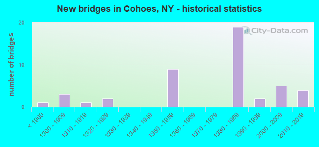
- New bridges - historical statistics
- 1Before 1900
- 31900-1909
- 11910-1919
- 21920-1929
- 91950-1959
- 191980-1989
- 21990-1999
- 52000-2009
- 42010-2019
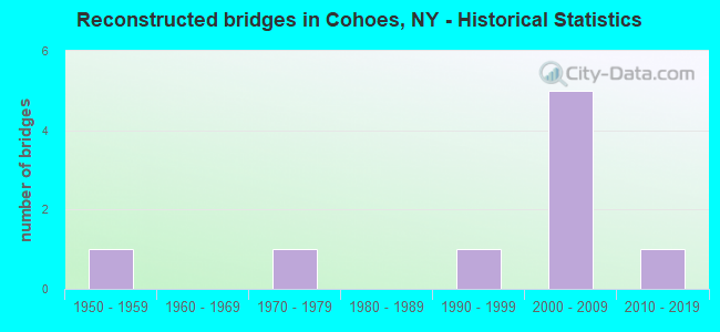
- Reconstructed bridges - Historical Statistics
- 11950-1959
- 01960-1969
- 11970-1979
- 01980-1989
- 11990-1999
- 52000-2009
- 12010-2019
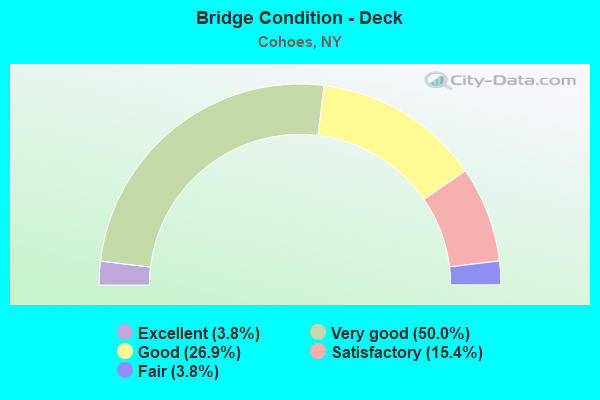
- Bridge Condition - Deck
- 3.8%Excellent
- 50.0%Very good
- 26.9%Good
- 15.4%Satisfactory
- 3.8%Fair
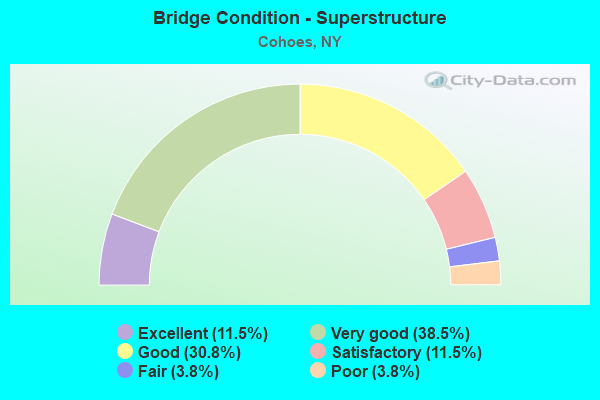
- Bridge Condition - Superstructure
- 11.5%Excellent
- 38.5%Very good
- 30.8%Good
- 11.5%Satisfactory
- 3.8%Fair
- 3.8%Poor
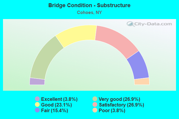
- Bridge Condition - Substructure
- 3.8%Excellent
- 26.9%Very good
- 23.1%Good
- 26.9%Satisfactory
- 15.4%Fair
- 3.8%Poor
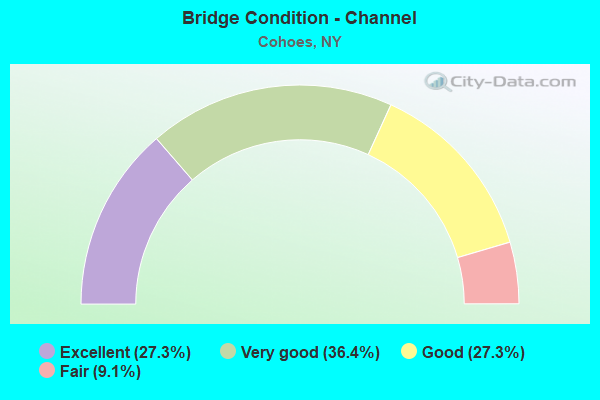
- Bridge Condition - Channel
- 27.3%Excellent
- 36.4%Very good
- 27.3%Good
- 9.1%Fair
Find on map >> Show street view
Structure Number: 100425, Location: JCT I87 & RTE 7 (Lat: 42.753092, Lng: -73.768942), Route carried "on" structure: State highway 7, Year Built: 2010, Status: Open, Structure Length: 5.97m (19.59ft), Average Daily Traffic: 18,324 (year 2011), Truck Traffic: 6%, Average Future Daily Traffic: 18,410 (year 2040), Design Load: HL 93, Features Intersected: 87I 87I11082049 NB, RTE
Minimum Vertical Clearance: 30+ m (98+ ft), Kilometerpoint: 0.000, Lanes on structure: 6, Lanes under structure: 6, Base Highway Network: Yes, Owner: State Highway Agency, Approaching Roadway Width: 25.3m (83.0ft), Material/Design: Steel continuous, Design/Construction: Stringer/Multi-beam, Number Of Spans In Main Unit: 2, Length of Maximum Span: 31.1m (102.0ft), Curb or Sidewalk Widths: Left: 2.3m (7.5ft), Right: 2.3m (7.5ft), Curb-To-Curb Width: 56.0m (183.7ft), Out-to-Out Width: 60.5m (198.5ft)
Condition: Deck: Very good, Superstructure: Excellent, Substructure: Very good, Operating Rating: 76.0 metric tons, Method Used To Determine Operating Rating: Load Factor (LF), Inventory Rating: 45.0 metric tons, Method Used To Determine Inventory Rating: Load Factor (LF), Structural Evaluation: Equal to present desirable criteria, Deck Geometry: Superior to present desirable criteria, Underclear: High priority of corrective action, Approach Roadway Alignment: Equal to present desirable criteria, Length Of Structure Improvement: 5.97m (19.59ft), Designated Inspection Frequency: Every 24 months, Inspection Date: October 2020, Bridge Improvement Cost: $10,635,000, Roadway Improvement Cost: $6,228,000, Total Project Cost: $16,863,000 ( Estimate for 2021), Deck Structure Type: Concrete Cast-file-Place, Wearing Surface/Protective System: Wearing Surface: Monolithic Concrete, Deck Protection: Epoxy Coated Reinforcing
Find on map >> Show street view
Structure Number: 1004261, Location: JCT S.H.2 & U.S.9 (Lat: 42.748406, Lng: -73.760836), Route carried "on" structure: State highway 2, Year Built: 1959, Year Reconstructed: 2014, Status: Open, Structure Length: 1.98m (6.50ft), Average Daily Traffic: 9,162 (year 2011), Truck Traffic: 6%, Average Future Daily Traffic: 9,205 (year 2040), Design Load: HL 93, Features Intersected: RTE 9
Minimum Vertical Clearance: 30+ m (98+ ft), Kilometerpoint: 0.885, Lanes on structure: 2, Lanes under structure: 4, Base Highway Network: Yes, Owner: State Highway Agency, Approaching Roadway Width: 7.3m (24.0ft), Material/Design: Steel, Design/Construction: Stringer/Multi-beam, Number Of Spans In Main Unit: 1, Length of Maximum Span: 18.3m (60.0ft), Curb or Sidewalk Widths: Left: 1.7m (5.6ft), Right: 0.0m, Curb-To-Curb Width: 11.0m (36.1ft), Out-to-Out Width: 15.5m (50.9ft)
Condition: Deck: Very good, Superstructure: Very good, Substructure: Good, Inventory Rating: 71.7 metric tons, Method Used To Determine Inventory Rating: Load Factor (LF), Structural Evaluation: Better than present minimum criteria, Deck Geometry: Equal to present minimum criteria, Underclear: High priority of corrective action, Approach Roadway Alignment: Meets minimum limits, Length Of Structure Improvement: 1.98m (6.50ft), Designated Inspection Frequency: Every 24 months, Inspection Date: July 2021, Bridge Improvement Cost: $1,149,000, Roadway Improvement Cost: $673,000, Total Project Cost: $1,821,000 ( Estimate for 2021), Deck Structure Type: Other, Wearing Surface/Protective System: Wearing Surface: Monolithic Concrete
Find on map >> Show street view
Structure Number: 1004262, Location: JCT S.H.2 & U.S.9 (Lat: 42.747803, Lng: -73.761017), Route carried "on" structure: State highway 2, Year Built: 1959, Year Reconstructed: 2014, Status: Open, Structure Length: 2.01m (6.59ft), Average Daily Traffic: 9,162 (year 2011), Truck Traffic: 6%, Average Future Daily Traffic: 9,205 (year 2040), Design Load: HL 93, Features Intersected: RTE 9
Minimum Vertical Clearance: 30+ m (98+ ft), Kilometerpoint: 0.885, Lanes on structure: 2, Lanes under structure: 4, Base Highway Network: Yes, Owner: State Highway Agency, Approaching Roadway Width: 7.3m (24.0ft), Material/Design: Steel, Design/Construction: Stringer/Multi-beam, Number Of Spans In Main Unit: 1, Length of Maximum Span: 19.8m (65.0ft), Curb-To-Curb Width: 10.9m (35.8ft), Out-to-Out Width: 14.2m (46.6ft)
Condition: Deck: Very good, Superstructure: Fair, Substructure: Very good, Inventory Rating: 67.1 metric tons, Method Used To Determine Inventory Rating: Load Factor (LF), Structural Evaluation: Somewhat better than minimum adequacy, Deck Geometry: Somewhat better than minimum adequacy, Underclear: High priority of corrective action, Approach Roadway Alignment: Meets minimum limits, Length Of Structure Improvement: 2.01m (6.59ft), Designated Inspection Frequency: Every 24 months, Inspection Date: July 2021, Bridge Improvement Cost: $1,055,000, Roadway Improvement Cost: $618,000, Total Project Cost: $1,674,000 ( Estimate for 2021), Deck Structure Type: Other, Wearing Surface/Protective System: Wearing Surface: Monolithic Concrete
Find on map >> Show street view
Structure Number: 10225, Location: 0.4 MI N JCT RTS 32 & 470 (Lat: 42.779408, Lng: -73.696569), Route carried "on" structure: State highway 32, Year Built: 2018, Status: Open, Structure Length: 24.29m (79.69ft), Average Daily Traffic: 11,201 (year 2018), Truck Traffic: 7%, Average Future Daily Traffic: 11,253 (year 2040), Design Load: H 20, Features Intersected: MOHAWK RIVER
Minimum Vertical Clearance: 30+ m (98+ ft), Kilometerpoint: 0.000, Lanes on structure: 3, Base Highway Network: Yes, Owner: State Highway Agency, Approaching Roadway Width: 11.9m (39.0ft), Material/Design: Steel continuous, Design/Construction: Stringer/Multi-beam, Number Of Spans In Main Unit: 5, Length of Maximum Span: 49.7m (163.1ft), Curb or Sidewalk Widths: Left: 1.5m (4.9ft), Right: 1.5m (4.9ft), Curb-To-Curb Width: 11.9m (39.0ft), Out-to-Out Width: 15.9m (52.2ft)
Condition: Deck: Satisfactory, Superstructure: Excellent, Substructure: Excellent, Channel: Excellent, Operating Rating: 47.0 metric tons, Method Used To Determine Operating Rating: Load and Resistance Factor Rating (LRFR) rating reported by rating factor(RF) method using HL-93 loadings, Inventory Rating: 36.3 metric tons, Method Used To Determine Inventory Rating: Load and Resistance Factor Rating (LRFR) rating reported by rating factor(RF) method using HL-93 loadings, Structural Evaluation: Superior to present desirable criteria, Deck Geometry: High priority of corrective action, Waterway Adequacy: Equal to present desirable criteria, Approach Roadway Alignment: Equal to present desirable criteria, Length Of Structure Improvement: 24.29m (79.69ft), Designated Inspection Frequency: Every 24 months, Underwater Inspection Frequency: Every 60 months, Inspection Date: August 2020, Underwater Inspection Date: June 2019, Bridge Improvement Cost: $8,247,000, Roadway Improvement Cost: $4,830,000, Total Project Cost: $13,077,000 ( Estimate for 2021), Deck Structure Type: Concrete Cast-file-Place, Wearing Surface/Protective System: Wearing Surface: Integral Concrete, Deck Protection: Epoxy Coated Reinforcing
Find on map >> Show street view
Structure Number: 103316, Location: NEW SPARROWBUSH OVER I87 (Lat: 42.759394, Lng: -73.764300), Route carried "on" structure: County highway , Year Built: 1984, Status: Open, Structure Length: 11.55m (37.89ft), Average Daily Traffic: 11,950 (year 2014), Truck Traffic: 2%, Average Future Daily Traffic: 14,785 (year 2040), Design Load: HS 20, Features Intersected: 87I 87I11082054, EXIT 6, Facility Carried by Structure: SPARROWBUSH RD
Minimum Vertical Clearance: 30+ m (98+ ft), Kilometerpoint: 1.722, Lanes on structure: 2, Lanes under structure: 11, Owner: State Highway Agency, Approaching Roadway Width: 11.9m (39.0ft), Skew: 1 degrees, Material/Design: Steel continuous, Design/Construction: Stringer/Multi-beam, Number Of Spans In Main Unit: 3, Length of Maximum Span: 39.0m (128.0ft), Curb-To-Curb Width: 11.9m (39.0ft), Out-to-Out Width: 12.8m (42.0ft)
Condition: Deck: Very good, Superstructure: Very good, Substructure: Satisfactory, Operating Rating: 79.8 metric tons, Method Used To Determine Operating Rating: Load Factor (LF), Inventory Rating: 48.1 metric tons, Method Used To Determine Inventory Rating: Load Factor (LF), Structural Evaluation: Equal to present minimum criteria, Deck Geometry: Somewhat better than minimum adequacy, Underclear: High priority of corrective action, Approach Roadway Alignment: Equal to present desirable criteria, Length Of Structure Improvement: 11.55m (37.89ft), Designated Inspection Frequency: Every 24 months, Inspection Date: June 2020, Bridge Improvement Cost: $3,201,000, Roadway Improvement Cost: $1,874,000, Total Project Cost: $5,075,000 ( Estimate for 2021), Deck Structure Type: Concrete Cast-file-Place, Wearing Surface/Protective System: Wearing Surface: Integral Concrete, Deck Protection: Epoxy Coated Reinforcing
Find on map >> Show street view
Structure Number: 1033171, Location: 1.9 MI N JCT I87 & RTE 7 (Lat: 42.776247, Lng: -73.760822), Route carried "on" structure: Interstate 87, Year Built: 2001, Status: Open, Structure Length: 3.32m (10.89ft), Average Daily Traffic: 46,347 (year 2015), Truck Traffic: 8%, Design Load: HS 25 or greater, Features Intersected: POLLOCK ROAD
Minimum Vertical Clearance: 30+ m (98+ ft), Kilometerpoint: 42.510, Lanes on structure: 3, Lanes under structure: 2, Base Highway Network: Yes, Owner: State Highway Agency, Approaching Roadway Width: 19.8m (65.0ft), Skew: 2 degrees, Material/Design: Prestressed concrete, Design/Construction: Box Beam or Girders - Multiple, Number Of Spans In Main Unit: 1, Length of Maximum Span: 31.6m (103.7ft), Curb-To-Curb Width: 19.4m (63.6ft), Out-to-Out Width: 20.3m (66.6ft)
Condition: Deck: Very good, Superstructure: Very good, Substructure: Very good, Operating Rating: 89.8 metric tons, Method Used To Determine Operating Rating: Load Factor (LF), Inventory Rating: 49.9 metric tons, Method Used To Determine Inventory Rating: Load Factor (LF), Structural Evaluation: Equal to present desirable criteria, Deck Geometry: Superior to present desirable criteria, Underclear: Somewhat better than minimum adequacy, Approach Roadway Alignment: Equal to present desirable criteria, Length Of Structure Improvement: 3.32m (10.89ft), Designated Inspection Frequency: Every 24 months, Inspection Date: May 2021, Bridge Improvement Cost: $2,543,000, Roadway Improvement Cost: $1,489,000, Total Project Cost: $4,032,000 ( Estimate for 2021), Deck Structure Type: Concrete Cast-file-Place, Wearing Surface/Protective System: Wearing Surface: Monolithic Concrete
Find on map >> Show street view
Structure Number: 1033172, Location: 1.7 MI N JCT I87 & NY 7 (Lat: 42.776386, Lng: -73.760181), Route carried "on" structure: Interstate 87, Year Built: 2001, Status: Open, Structure Length: 3.32m (10.89ft), Average Daily Traffic: 38,029 (year 2015), Truck Traffic: 8%, Average Future Daily Traffic: 60,264 (year 2040), Design Load: HS 25 or greater, Features Intersected: POLLOCK ROAD
Minimum Vertical Clearance: 30+ m (98+ ft), Kilometerpoint: 42.494, Lanes on structure: 3, Lanes under structure: 2, Base Highway Network: Yes, Owner: State Highway Agency, Approaching Roadway Width: 19.2m (63.0ft), Skew: 2 degrees, Material/Design: Prestressed concrete, Design/Construction: Box Beam or Girders - Multiple, Number Of Spans In Main Unit: 1, Length of Maximum Span: 31.9m (104.7ft), Curb-To-Curb Width: 19.3m (63.3ft), Out-to-Out Width: 20.3m (66.6ft)
Condition: Deck: Very good, Superstructure: Very good, Substructure: Very good, Operating Rating: 89.8 metric tons, Method Used To Determine Operating Rating: Load Factor (LF), Inventory Rating: 49.9 metric tons, Method Used To Determine Inventory Rating: Load Factor (LF), Structural Evaluation: Equal to present desirable criteria, Deck Geometry: Superior to present desirable criteria, Underclear: Meets minimum limits, Approach Roadway Alignment: Equal to present desirable criteria, Length Of Structure Improvement: 3.32m (10.89ft), Designated Inspection Frequency: Every 24 months, Inspection Date: May 2021, Bridge Improvement Cost: $2,465,000, Roadway Improvement Cost: $1,444,000, Total Project Cost: $3,909,000 ( Estimate for 2021), Deck Structure Type: Concrete Cast-file-Place, Wearing Surface/Protective System: Wearing Surface: Monolithic Concrete
Find on map >> Show street view
Structure Number: 105339, Location: 0.1 MI S.JCT RTS 7 & 9 (Lat: 42.746833, Lng: -73.761308), Route carried "on" structure: Ramp US , Year Built: 1959, Year Reconstructed: 2014, Status: Open, Structure Length: 1.95m (6.40ft), Average Daily Traffic: 6,260 (year 2018), Truck Traffic: 6%, Average Future Daily Traffic: 6,289 (year 2040), Features Intersected: RTE 9, Facility Carried by Structure: SHOP CTR X-OVER 9
Minimum Vertical Clearance: 30+ m (98+ ft), Kilometerpoint: 0.000, Lanes on structure: 1, Lanes under structure: 4, Owner: State Highway Agency, Approaching Roadway Width: 6.4m (21.0ft), Material/Design: Steel, Design/Construction: Stringer/Multi-beam, Number Of Spans In Main Unit: 1, Length of Maximum Span: 18.2m (59.7ft), Curb or Sidewalk Widths: Left: 0.6m (2.0ft), Right: 0.5m (1.6ft), Curb-To-Curb Width: 6.1m (20.0ft), Out-to-Out Width: 7.8m (25.6ft)
Condition: Deck: Satisfactory, Superstructure: Good, Substructure: Satisfactory, Operating Rating: 85.6 metric tons, Method Used To Determine Operating Rating: Field evaluation and documented engineering judgment, Inventory Rating: 32.7 metric tons, Method Used To Determine Inventory Rating: Field evaluation and documented engineering judgment, Structural Evaluation: Equal to present minimum criteria, Deck Geometry: Somewhat better than minimum adequacy, Underclear: High priority of corrective action, Approach Roadway Alignment: Meets minimum limits, Length Of Structure Improvement: 1.95m (6.40ft), Designated Inspection Frequency: Every 24 months, Inspection Date: July 2021, Bridge Improvement Cost: $565,000, Roadway Improvement Cost: $331,000, Total Project Cost: $896,000 ( Estimate for 2021), Deck Structure Type: Concrete Cast-file-Place, Wearing Surface/Protective System: Wearing Surface: Bituminous
Find on map >> Show street view
Structure Number: 107244, Location: 1.1MI E JCT ALT RTE 7 & 9 (Lat: 42.757039, Lng: -73.736425), Route carried "on" structure: County highway , Year Built: 1985, Status: Open, Structure Length: 7.38m (24.21ft), Average Daily Traffic: 3,279 (year 2018), Truck Traffic: 3%, Average Future Daily Traffic: 4,057 (year 2040), Design Load: HS 20, Features Intersected: 7 7 1108 1156 WB, RTE 7, Facility Carried by Structure: MILLER ROAD
Minimum Vertical Clearance: 30+ m (98+ ft), Kilometerpoint: 0.676, Lanes on structure: 2, Lanes under structure: 5, Owner: State Highway Agency, Approaching Roadway Width: 11.6m (38.1ft), Skew: 3 degrees, Material/Design: Steel, Design/Construction: Stringer/Multi-beam, Number Of Spans In Main Unit: 2, Length of Maximum Span: 38.4m (126.0ft), Curb-To-Curb Width: 11.3m (37.1ft), Out-to-Out Width: 12.2m (40.0ft)
Condition: Deck: Good, Superstructure: Very good, Substructure: Fair, Operating Rating: 84.2 metric tons, Method Used To Determine Operating Rating: Load and Resistance Factor Rating (LRFR) rating reported by rating factor(RF) method using HL-93 loadings, Inventory Rating: 65.1 metric tons, Method Used To Determine Inventory Rating: Load and Resistance Factor Rating (LRFR) rating reported by rating factor(RF) method using HL-93 loadings, Structural Evaluation: Somewhat better than minimum adequacy, Deck Geometry: Somewhat better than minimum adequacy, Underclear: Better than present minimum criteria, Approach Roadway Alignment: Equal to present desirable criteria, Length Of Structure Improvement: 7.37m (24.18ft), Designated Inspection Frequency: Every 24 months, Inspection Date: March 2020, Bridge Improvement Cost: $2,072,000, Roadway Improvement Cost: $1,213,000, Total Project Cost: $3,285,000 ( Estimate for 2021), Deck Structure Type: Concrete Cast-file-Place, Wearing Surface/Protective System: Wearing Surface: Integral Concrete, Deck Protection: Epoxy Coated Reinforcing
Find on map >> Show street view
Structure Number: 107245, Location: 1.1MI W JCT ALT RTE7&I787 (Lat: 42.750481, Lng: -73.716183), Route carried "on" structure: City street , Year Built: 1985, Status: Open, Structure Length: 7.59m (24.90ft), Average Daily Traffic: 2,958 (year 2016), Truck Traffic: 5%, Average Future Daily Traffic: 4,141 (year 2036), Design Load: HS 20, Features Intersected: 7 7 1108 1167 WB, RTE 7, Facility Carried by Structure: BOGHT ROAD
Minimum Vertical Clearance: 30+ m (98+ ft), Kilometerpoint: 2.204, Lanes on structure: 2, Lanes under structure: 5, Owner: State Highway Agency, Approaching Roadway Width: 11.6m (38.1ft), Skew: 3 degrees, Material/Design: Steel continuous, Design/Construction: Stringer/Multi-beam, Number Of Spans In Main Unit: 2, Length of Maximum Span: 37.1m (121.7ft), Curb-To-Curb Width: 11.3m (37.1ft), Out-to-Out Width: 12.2m (40.0ft)
Condition: Deck: Good, Superstructure: Good, Substructure: Fair, Operating Rating: 66.1 metric tons, Method Used To Determine Operating Rating: Load and Resistance Factor Rating (LRFR) rating reported by rating factor(RF) method using HL-93 loadings, Inventory Rating: 50.9 metric tons, Method Used To Determine Inventory Rating: Load and Resistance Factor Rating (LRFR) rating reported by rating factor(RF) method using HL-93 loadings, Structural Evaluation: Somewhat better than minimum adequacy, Deck Geometry: Somewhat better than minimum adequacy, Underclear: Equal to present minimum criteria, Approach Roadway Alignment: Equal to present desirable criteria, Length Of Structure Improvement: 7.58m (24.87ft), Designated Inspection Frequency: Every 24 months, Inspection Date: March 2020, Bridge Improvement Cost: $2,177,000, Roadway Improvement Cost: $1,275,000, Total Project Cost: $3,452,000 ( Estimate for 2021), Deck Structure Type: Concrete Cast-file-Place, Wearing Surface/Protective System: Wearing Surface: Integral Concrete, Deck Protection: Epoxy Coated Reinforcing
Find on map >> Show street view
Structure Number: 1072469, Location: 0.5 MI W JCT RTS 7A+I-787 (Lat: 42.746608, Lng: -73.707003), Route carried "on" structure: Alternate State highway 7, Year Built: 1983, Year Reconstructed: 2019, Status: Open, Structure Length: 4.02m (13.19ft), Average Daily Traffic: 51,411 (year 2020), Truck Traffic: 8%, Average Future Daily Traffic: 59,575 (year 2040), Design Load: HS 20+Mod, Features Intersected: ELM STREET
Minimum Vertical Clearance: 30+ m (98+ ft), Kilometerpoint: 11.166, Lanes on structure: 4, Lanes under structure: 2, Base Highway Network: Yes, Owner: State Highway Agency, Approaching Roadway Width: 34.7m (113.8ft), Skew: 34 degrees, Material/Design: Steel, Design/Construction: Stringer/Multi-beam, Number Of Spans In Main Unit: 1, Length of Maximum Span: 39.3m (128.9ft), Curb-To-Curb Width: 33.5m (109.9ft), Out-to-Out Width: 35.6m (116.8ft)
Condition: Deck: Good, Superstructure: Very good, Substructure: Good, Operating Rating: 85.9 metric tons, Method Used To Determine Operating Rating: Load and Resistance Factor Rating (LRFR) rating reported by rating factor(RF) method using HL-93 loadings, Inventory Rating: 66.1 metric tons, Method Used To Determine Inventory Rating: Load and Resistance Factor Rating (LRFR) rating reported by rating factor(RF) method using HL-93 loadings, Structural Evaluation: Better than present minimum criteria, Deck Geometry: Superior to present desirable criteria, Underclear: Meets minimum limits, Approach Roadway Alignment: Equal to present desirable criteria, Length Of Structure Improvement: 4.02m (13.19ft), Designated Inspection Frequency: Every 24 months, Inspection Date: March 2020, Bridge Improvement Cost: $4,626,000, Roadway Improvement Cost: $2,709,000, Total Project Cost: $7,336,000 ( Estimate for 2021), Deck Structure Type: Concrete Cast-file-Place, Wearing Surface/Protective System: Wearing Surface: Epoxy Overlay, Deck Protection: Epoxy Coated Reinforcing
Find on map >> Show street view
Structure Number: 107286, Location: 0.9 MI.N OF LATHAM ON RT9 (Lat: 42.760356, Lng: -73.756556), Route carried "on" structure: US 9, Year Built: 1984, Status: Open, Structure Length: 7.22m (23.69ft), Average Daily Traffic: 27,647 (year 2016), Truck Traffic: 4%, Average Future Daily Traffic: 27,776 (year 2040), Design Load: HS 20, Features Intersected: 7 7 11081145, RTE 7
Minimum Vertical Clearance: 30+ m (98+ ft), Kilometerpoint: 15.109, Lanes on structure: 7, Lanes under structure: 7, Base Highway Network: Yes, Owner: State Highway Agency, Approaching Roadway Width: 27.4m (89.9ft), Skew: 20 degrees, Material/Design: Steel continuous, Design/Construction: Stringer/Multi-beam, Number Of Spans In Main Unit: 2, Length of Maximum Span: 37.7m (123.7ft), Curb or Sidewalk Widths: Left: 1.5m (4.9ft), Right: 1.5m (4.9ft), Curb-To-Curb Width: 27.4m (89.9ft), Out-to-Out Width: 31.1m (102.0ft)
Condition: Deck: Good, Superstructure: Good, Substructure: Fair, Operating Rating: 67.1 metric tons, Method Used To Determine Operating Rating: Load and Resistance Factor Rating (LRFR) rating reported by rating factor(RF) method using HL-93 loadings, Inventory Rating: 51.5 metric tons, Method Used To Determine Inventory Rating: Load and Resistance Factor Rating (LRFR) rating reported by rating factor(RF) method using HL-93 loadings, Structural Evaluation: Somewhat better than minimum adequacy, Deck Geometry: Somewhat better than minimum adequacy, Underclear: Meets minimum limits, Approach Roadway Alignment: Equal to present desirable criteria, Length Of Structure Improvement: 7.22m (23.69ft), Designated Inspection Frequency: Every 24 months, Inspection Date: September 2020, Bridge Improvement Cost: $5,346,000, Roadway Improvement Cost: $3,130,000, Total Project Cost: $8,476,000 ( Estimate for 2021), Deck Structure Type: Concrete Cast-file-Place, Wearing Surface/Protective System: Wearing Surface: Epoxy Overlay, Deck Protection: Epoxy Coated Reinforcing
Find on map >> Show street view
Structure Number: 1073009, Location: .2 MI.W.INTER.RTES9&ALT.7 (Lat: 42.763103, Lng: -73.759094), Route carried "on" structure: Ramp State highway , Year Built: 1986, Status: Open, Structure Length: 3.66m (12.01ft), Average Daily Traffic: 5,341 (year 2020), Truck Traffic: 18%, Average Future Daily Traffic: 6,189 (year 2040), Design Load: HS 20, Features Intersected: RT7WB TO I87NB, Facility Carried by Structure: RT7-RT9 CONNECTOR
Minimum Vertical Clearance: 30+ m (98+ ft), Kilometerpoint: 0.241, Lanes on structure: 3, Lanes under structure: 1, Owner: State Highway Agency, Approaching Roadway Width: 20.4m (66.9ft), Skew: 30 degrees, Material/Design: Steel, Design/Construction: Stringer/Multi-beam, Number Of Spans In Main Unit: 1, Length of Maximum Span: 35.0m (114.8ft), Curb-To-Curb Width: 19.5m (64.0ft), Out-to-Out Width: 21.3m (69.9ft)
Condition: Deck: Good, Superstructure: Very good, Substructure: Satisfactory, Operating Rating: 97.6 metric tons, Method Used To Determine Operating Rating: Field evaluation and documented engineering judgment, Inventory Rating: 32.7 metric tons, Method Used To Determine Inventory Rating: Field evaluation and documented engineering judgment, Structural Evaluation: Equal to present minimum criteria, Deck Geometry: Superior to present desirable criteria, Underclear: Better than present minimum criteria, Approach Roadway Alignment: Equal to present desirable criteria, Length Of Structure Improvement: 3.65m (11.98ft), Designated Inspection Frequency: Every 24 months, Inspection Date: April 2020, Bridge Improvement Cost: $2,284,000, Roadway Improvement Cost: $1,337,000, Total Project Cost: $3,621,000 ( Estimate for 2021), Deck Structure Type: Concrete Cast-file-Place, Wearing Surface/Protective System: Wearing Surface: Integral Concrete, Deck Protection: Epoxy Coated Reinforcing
Find on map >> Show street view
Structure Number: 107309, Location: 1MI N OLD LOUDON RD & 7 (Lat: 42.759850, Lng: -73.753831), Route carried "on" structure: Other road , Year Built: 1986, Status: Open, Structure Length: 7.07m (23.20ft), Average Daily Traffic: 5,643 (year 2017), Truck Traffic: 3%, Average Future Daily Traffic: 6,982 (year 2040), Design Load: HS 20, Features Intersected: 7 7 11081147, RTE 7, Facility Carried by Structure: OLD LOUDON ROAD
Minimum Vertical Clearance: 30+ m (98+ ft), Kilometerpoint: 3.041, Lanes on structure: 2, Lanes under structure: 7, Owner: State Highway Agency, Approaching Roadway Width: 12.2m (40.0ft), Skew: 1 degrees, Material/Design: Steel continuous, Design/Construction: Stringer/Multi-beam, Number Of Spans In Main Unit: 2, Length of Maximum Span: 35.0m (114.8ft), Curb or Sidewalk Widths: Left: 0.0m, Right: 1.5m (4.9ft), Curb-To-Curb Width: 12.0m (39.4ft), Out-to-Out Width: 14.3m (46.9ft)
Condition: Deck: Very good, Superstructure: Good, Substructure: Good, Operating Rating: 68.0 metric tons, Method Used To Determine Operating Rating: Load and Resistance Factor Rating (LRFR) rating reported by rating factor(RF) method using HL-93 loadings, Inventory Rating: 52.5 metric tons, Method Used To Determine Inventory Rating: Load and Resistance Factor Rating (LRFR) rating reported by rating factor(RF) method using HL-93 loadings, Structural Evaluation: Better than present minimum criteria, Deck Geometry: Somewhat better than minimum adequacy, Underclear: High priority of corrective action, Approach Roadway Alignment: Equal to present desirable criteria, Length Of Structure Improvement: 7.07m (23.20ft), Designated Inspection Frequency: Every 24 months, Inspection Date: July 2020, Bridge Improvement Cost: $2,308,000, Roadway Improvement Cost: $1,352,000, Total Project Cost: $3,660,000 ( Estimate for 2021), Deck Structure Type: Concrete Cast-file-Place, Wearing Surface/Protective System: Wearing Surface: Bituminous, Deck Protection: Epoxy Coated Reinforcing
Find on map >> Show street view
Structure Number: 10731, Location: INTERS.RTES 87I & 7, WB-7 (Lat: 42.763353, Lng: -73.762339), Route carried "on" structure: State highway 7, Year Built: 1985, Status: Open, Structure Length: 9.75m (31.99ft), Average Daily Traffic: 12,278 (year 2017), Truck Traffic: 10%, Average Future Daily Traffic: 19,456 (year 2040), Design Load: HS 20, Features Intersected: 87I 87I11082058, 87I 87I
Minimum Vertical Clearance: 30+ m (98+ ft), Kilometerpoint: 1.995, Lanes on structure: 2, Lanes under structure: 8, Owner: State Highway Agency, Approaching Roadway Width: 10.7m (35.1ft), Skew: 2 degrees, Material/Design: Steel, Design/Construction: Stringer/Multi-beam, Number Of Spans In Main Unit: 3, Length of Maximum Span: 35.6m (116.8ft), Curb-To-Curb Width: 10.4m (34.1ft), Out-to-Out Width: 11.3m (37.1ft)
Condition: Deck: Very good, Superstructure: Very good, Substructure: Fair, Inventory Rating: 74.4 metric tons, Method Used To Determine Inventory Rating: Load Factor (LF), Structural Evaluation: Somewhat better than minimum adequacy, Deck Geometry: Meets minimum limits, Underclear: Meets minimum limits, Approach Roadway Alignment: Equal to present desirable criteria, Length Of Structure Improvement: 9.75m (31.99ft), Designated Inspection Frequency: Every 24 months, Inspection Date: August 2020, Bridge Improvement Cost: $2,481,000, Roadway Improvement Cost: $1,453,000, Total Project Cost: $3,935,000 ( Estimate for 2021), Deck Structure Type: Concrete Cast-file-Place, Wearing Surface/Protective System: Wearing Surface: Integral Concrete, Deck Protection: Epoxy Coated Reinforcing
Find on map >> Show street view
Structure Number: 107311, Location: INTER RTES 87I & 7 E.B. (Lat: 42.763031, Lng: -73.762669), Route carried "on" structure: State highway 7, Year Built: 1985, Status: Open, Structure Length: 9.75m (31.99ft), Average Daily Traffic: 12,278 (year 2017), Truck Traffic: 10%, Average Future Daily Traffic: 19,456 (year 2040), Design Load: HS 20, Features Intersected: 87I 87I11082057, 87I 87I
Minimum Vertical Clearance: 30+ m (98+ ft), Kilometerpoint: 1.995, Lanes on structure: 2, Lanes under structure: 8, Owner: State Highway Agency, Approaching Roadway Width: 10.7m (35.1ft), Skew: 2 degrees, Material/Design: Steel, Design/Construction: Stringer/Multi-beam, Number Of Spans In Main Unit: 3, Length of Maximum Span: 35.6m (116.8ft), Curb-To-Curb Width: 10.4m (34.1ft), Out-to-Out Width: 11.3m (37.1ft)
Condition: Deck: Good, Superstructure: Good, Substructure: Poor, Inventory Rating: 74.4 metric tons, Method Used To Determine Inventory Rating: Load Factor (LF), Structural Evaluation: Meets minimum limits, Deck Geometry: Meets minimum limits, Underclear: Meets minimum limits, Approach Roadway Alignment: Equal to present desirable criteria, Length Of Structure Improvement: 9.75m (31.99ft), Designated Inspection Frequency: Every 24 months, Inspection Date: August 2020, Bridge Improvement Cost: $2,453,000, Roadway Improvement Cost: $1,437,000, Total Project Cost: $3,890,000 ( Estimate for 2021), Deck Structure Type: Concrete Cast-file-Place, Wearing Surface/Protective System: Wearing Surface: Integral Concrete, Deck Protection: Epoxy Coated Reinforcing
Find on map >> Show street view
Structure Number: 220039, Location: CITY OF COHOES (Lat: 42.768308, Lng: -73.696517), Route carried "on" structure: City street , Year Built: 2010, Status: Open, Structure Length: 14.02m (46.00ft), Average Daily Traffic: 4,987 (year 2019), Truck Traffic: 2%, Average Future Daily Traffic: 6,170 (year 2040), Design Load: HL 93, Features Intersected: MOHAWK RIVER, Facility Carried by Structure: BRIDGE AVENUE
Minimum Vertical Clearance: 30+ m (98+ ft), Kilometerpoint: 0.418, Lanes on structure: 2, Owner: City or Municipal Highway Agency, Approaching Roadway Width: 8.5m (27.9ft), Skew: 1 degrees, Material/Design: Steel continuous, Design/Construction: Stringer/Multi-beam, Number Of Spans In Main Unit: 3, Length of Maximum Span: 55.0m (180.4ft), Curb or Sidewalk Widths: Left: 1.6m (5.2ft), Right: 1.6m (5.2ft), Curb-To-Curb Width: 8.4m (27.6ft), Out-to-Out Width: 12.4m (40.7ft)
Condition: Deck: Excellent, Superstructure: Excellent, Substructure: Very good, Channel: Excellent, Operating Rating: 67.1 metric tons, Method Used To Determine Operating Rating: Load Factor (LF), Inventory Rating: 39.9 metric tons, Method Used To Determine Inventory Rating: Load Factor (LF), Structural Evaluation: Equal to present desirable criteria, Deck Geometry: High priority of corrective action, Waterway Adequacy: Equal to present desirable criteria, Approach Roadway Alignment: Equal to present desirable criteria, Length Of Structure Improvement: 14.02m (46.00ft), Designated Inspection Frequency: Every 24 months, Underwater Inspection Frequency: Every 60 months, Inspection Date: August 2020, Underwater Inspection Date: September 2017, Bridge Improvement Cost: $4,007,000, Roadway Improvement Cost: $2,347,000, Total Project Cost: $6,354,000 ( Estimate for 2021), Deck Structure Type: Concrete Cast-file-Place, Wearing Surface/Protective System: Wearing Surface: Integral Concrete, Deck Protection: Epoxy Coated Reinforcing
Find on map >> Show street view
Structure Number: 220046, Location: 0.1 MI E JCT I787 + SH470 (Lat: 42.773850, Lng: -73.694731), Route carried "on" structure: State highway 470, Year Built: 1994, Status: Open, Structure Length: 4.48m (14.70ft), Average Daily Traffic: 11,600 (year 2018), Truck Traffic: 2%, Average Future Daily Traffic: 14,091 (year 2040), Design Load: HS 25 or greater, Features Intersected: W BR MOHAWK RIVER
Minimum Vertical Clearance: 30+ m (98+ ft), Kilometerpoint: 3.315, Lanes on structure: 2, Base Highway Network: Yes, Owner: City or Municipal Highway Agency, Approaching Roadway Width: 12.2m (40.0ft), Material/Design: Steel continuous, Design/Construction: Stringer/Multi-beam, Number Of Spans In Main Unit: 2, Length of Maximum Span: 21.9m (71.9ft), Curb or Sidewalk Widths: Left: 2.1m (6.9ft), Right: 2.1m (6.9ft), Curb-To-Curb Width: 12.2m (40.0ft), Out-to-Out Width: 17.1m (56.1ft)
Condition: Deck: Satisfactory, Superstructure: Satisfactory, Substructure: Satisfactory, Channel: Very good, Operating Rating: 89.8 metric tons, Method Used To Determine Operating Rating: Load Factor (LF), Inventory Rating: 73.5 metric tons, Method Used To Determine Inventory Rating: Load Factor (LF), Structural Evaluation: Equal to present minimum criteria, Deck Geometry: Somewhat better than minimum adequacy, Waterway Adequacy: Equal to present minimum criteria, Approach Roadway Alignment: Equal to present desirable criteria, Length Of Structure Improvement: 4.48m (14.70ft), Designated Inspection Frequency: Every 24 months, Inspection Date: July 2020, Bridge Improvement Cost: $2,056,000, Roadway Improvement Cost: $1,204,000, Total Project Cost: $3,259,000 ( Estimate for 2021), Deck Structure Type: Concrete Cast-file-Place, Wearing Surface/Protective System: Wearing Surface: Integral Concrete, Deck Protection: Epoxy Coated Reinforcing
Find on map >> Show street view
Structure Number: 220047, Location: 0.4 MI E JCT SH 32 & 470 (Lat: 42.773469, Lng: -73.691269), Route carried "on" structure: State highway 470, Year Built: 1986, Status: Open, Structure Length: 9.17m (30.09ft), Average Daily Traffic: 11,600 (year 2018), Truck Traffic: 2%, Average Future Daily Traffic: 14,091 (year 2040), Design Load: HS 20, Features Intersected: E.BR MOHAWK RIVER
Minimum Vertical Clearance: 30+ m (98+ ft), Kilometerpoint: 3.604, Lanes on structure: 2, Base Highway Network: Yes, Owner: City or Municipal Highway Agency, Approaching Roadway Width: 8.5m (27.9ft), Material/Design: Steel continuous, Design/Construction: Stringer/Multi-beam, Number Of Spans In Main Unit: 3, Length of Maximum Span: 39.6m (129.9ft), Curb or Sidewalk Widths: Left: 1.5m (4.9ft), Right: 1.5m (4.9ft), Curb-To-Curb Width: 8.5m (27.9ft), Out-to-Out Width: 12.2m (40.0ft)
Condition: Deck: Good, Superstructure: Good, Substructure: Good, Channel: Very good, Operating Rating: 76.2 metric tons, Method Used To Determine Operating Rating: Load Factor (LF), Inventory Rating: 45.4 metric tons, Method Used To Determine Inventory Rating: Load Factor (LF), Structural Evaluation: Better than present minimum criteria, Deck Geometry: Meets minimum limits, Waterway Adequacy: Equal to present minimum criteria, Approach Roadway Alignment: Equal to present desirable criteria, Length Of Structure Improvement: 9.17m (30.09ft), Designated Inspection Frequency: Every 24 months, Inspection Date: July 2020, Bridge Improvement Cost: $2,560,000, Roadway Improvement Cost: $1,499,000, Total Project Cost: $4,060,000 ( Estimate for 2021), Deck Structure Type: Concrete Cast-file-Place, Wearing Surface/Protective System: Wearing Surface: Integral Concrete, Deck Protection: Epoxy Coated Reinforcing
Find on map >> Show street view
Structure Number: 400558, Location: JCT OF RT 9 & MOHAWK RV (Lat: 42.822819, Lng: -73.732397), Route carried "on" structure: US 9, Year Built: 1996, Status: Open, Structure Length: 37.46m (122.90ft), Average Daily Traffic: 15,777 (year 2016), Truck Traffic: 6%, Average Future Daily Traffic: 15,851 (year 2040), Design Load: HS 25 or greater, Features Intersected: MOHAWK RIVER
Minimum Vertical Clearance: 30+ m (98+ ft), Kilometerpoint: 0.000, Lanes on structure: 4, Base Highway Network: Yes, Owner: State Highway Agency, Approaching Roadway Width: 24.4m (80.1ft), Skew: 20 degrees, Navigation Control: Yes ( Vertical Clearance: 6.0m (19.7ft), Horizontal Clearance: 60.9m (199.8ft)), Material/Design: Steel continuous, Design/Construction: Stringer/Multi-beam, Number Of Spans In Main Unit: 5, Length of Maximum Span: 91.4m (299.9ft), Curb-To-Curb Width: 24.4m (80.1ft), Out-to-Out Width: 25.3m (83.0ft)
Condition: Deck: Very good, Superstructure: Very good, Substructure: Very good, Channel: Very good, Operating Rating: 71.7 metric tons, Method Used To Determine Operating Rating: Load Factor (LF), Inventory Rating: 42.6 metric tons, Method Used To Determine Inventory Rating: Load Factor (LF), Structural Evaluation: Equal to present desirable criteria, Deck Geometry: Superior to present desirable criteria, Waterway Adequacy: Equal to present minimum criteria, Approach Roadway Alignment: Equal to present desirable criteria, Length Of Structure Improvement: 37.45m (122.87ft), Designated Inspection Frequency: Every 24 months, Underwater Inspection Frequency: Every 60 months, Inspection Date: September 2020, Underwater Inspection Date: September 2017, Bridge Improvement Cost: $19,412,000, Roadway Improvement Cost: $11,368,000, Total Project Cost: $30,780,000 ( Estimate for 2021), Deck Structure Type: Concrete Cast-file-Place, Wearing Surface/Protective System: Wearing Surface: Integral Concrete, Deck Protection: Epoxy Coated Reinforcing
Find on map >> Show street view
Structure Number: 4033181, Location: JCT.87I&MOHK.R& BARGE CAN (Lat: 42.792111, Lng: -73.762108), Route carried "on" structure: Interstate 87, Year Built: 1959, Year Reconstructed: 2013, Status: Open, Structure Length: 23.56m (77.30ft), Average Daily Traffic: 52,333 (year 2006), Truck Traffic: 9%, Design Load: HS 20+Mod, Features Intersected: ISLAND VIEW ROAD, TOW PA
Minimum Vertical Clearance: 4.67m (15.32ft), Kilometerpoint: 13.194, Lanes on structure: 3, Lanes under structure: 4, Base Highway Network: Yes, Owner: State Highway Agency, Approaching Roadway Width: 13.4m (44.0ft), Navigation Control: Yes ( Vertical Clearance: 7.9m (25.9ft), Horizontal Clearance: 60.9m (199.8ft)), Material/Design: Steel, Design/Construction: Arch - Thru, Number Of Spans In Main Unit: 1, Number Of Approach Spans: 6, Length of Maximum Span: 171.0m (561.0ft), Curb-To-Curb Width: 12.8m (42.0ft), Out-to-Out Width: 13.7m (44.9ft)
Condition: Deck: Very good, Superstructure: Satisfactory, Substructure: Satisfactory, Channel: Very good, Operating Rating: 58.1 metric tons, Method Used To Determine Operating Rating: Load Factor (LF), Inventory Rating: 33.6 metric tons, Method Used To Determine Inventory Rating: Load Factor (LF), Structural Evaluation: Equal to present minimum criteria, Deck Geometry: High priority of corrective action, Underclear: High priority of corrective action, Waterway Adequacy: Equal to present minimum criteria, Approach Roadway Alignment: Equal to present desirable criteria, Length Of Structure Improvement: 23.56m (77.30ft), Designated Inspection Frequency: Every 24 months, Critical Feature Inspection Frequency: Every 24 months, Inspection Date: December 2021, Critical Feature Inspection Date: December 2021, Bridge Improvement Cost: $14,414,000, Roadway Improvement Cost: $8,441,000, Total Project Cost: $22,855,000 ( Estimate for 2021), Deck Structure Type: Concrete Precast Panels, Wearing Surface/Protective System: Wearing Surface: Epoxy Overlay
Find on map >> Show street view
Structure Number: 4033182, Location: JCT.87I&MOHK.R& BARGE CAN (Lat: 42.792250, Lng: -73.761919), Route carried "on" structure: Interstate 87, Year Built: 1959, Year Reconstructed: 2012, Status: Open, Structure Length: 23.56m (77.30ft), Average Daily Traffic: 37,508 (year 2018), Truck Traffic: 7%, Average Future Daily Traffic: 59,439 (year 2040), Design Load: HS 20+Mod, Features Intersected: ISLAND VIEW ROAD, MOHAWK
Minimum Vertical Clearance: 4.75m (15.58ft), Kilometerpoint: 0.000, Lanes on structure: 3, Lanes under structure: 4, Base Highway Network: Yes, Owner: State Highway Agency, Approaching Roadway Width: 13.4m (44.0ft), Navigation Control: Yes ( Vertical Clearance: 7.9m (25.9ft), Horizontal Clearance: 60.9m (199.8ft)), Material/Design: Steel, Design/Construction: Arch - Thru, Number Of Spans In Main Unit: 1, Number Of Approach Spans: 6, Length of Maximum Span: 171.0m (561.0ft), Curb-To-Curb Width: 12.8m (42.0ft), Out-to-Out Width: 13.7m (44.9ft)
Condition: Deck: Very good, Superstructure: Good, Substructure: Good, Channel: Excellent, Operating Rating: 75.3 metric tons, Method Used To Determine Operating Rating: Load Factor (LF), Inventory Rating: 45.4 metric tons, Method Used To Determine Inventory Rating: Load Factor (LF), Structural Evaluation: Better than present minimum criteria, Deck Geometry: Meets minimum limits, Underclear: High priority of corrective action, Waterway Adequacy: Equal to present minimum criteria, Approach Roadway Alignment: Equal to present desirable criteria, Length Of Structure Improvement: 23.56m (77.30ft), Designated Inspection Frequency: Every 24 months, Critical Feature Inspection Frequency: Every 24 months, Inspection Date: November 2020, Critical Feature Inspection Date: November 2020, Bridge Improvement Cost: $14,484,000, Roadway Improvement Cost: $8,482,000, Total Project Cost: $22,967,000 ( Estimate for 2021), Deck Structure Type: Concrete Precast Panels, Wearing Surface/Protective System: Wearing Surface: Epoxy Overlay
Find on map >> Show street view
Structure Number: 409322, Location: .2 MI W JCT US 4 & SH 470 (Lat: 42.771378, Lng: -73.680381), Route carried "on" structure: City street 470, Year Built: 1924, Year Reconstructed: 1997, Status: Open, Structure Length: 24.66m (80.91ft), Average Daily Traffic: 11,238 (year 2016), Truck Traffic: 2%, Average Future Daily Traffic: 13,651 (year 2040), Design Load: HS 25 or greater, Features Intersected: HUDSON RIVER
Minimum Vertical Clearance: 30+ m (98+ ft), Kilometerpoint: 0.000, Lanes on structure: 2, Base Highway Network: Yes, Owner: State Highway Agency, Approaching Roadway Width: 8.5m (27.9ft), Navigation Control: Yes ( Vertical Clearance: 6.0m (19.7ft), Horizontal Clearance: 51.8m (169.9ft)), Material/Design: Steel continuous, Design/Construction: Stringer/Multi-beam, Number Of Spans In Main Unit: 5, Length of Maximum Span: 68.2m (223.8ft), Curb or Sidewalk Widths: Left: 1.5m (4.9ft), Right: 1.5m (4.9ft), Curb-To-Curb Width: 8.5m (27.9ft), Out-to-Out Width: 12.3m (40.4ft)
Condition: Deck: Fair, Superstructure: Good, Substructure: Satisfactory, Channel: Good, Operating Rating: 69.9 metric tons, Method Used To Determine Operating Rating: Load Factor (LF), Inventory Rating: 41.7 metric tons, Method Used To Determine Inventory Rating: Load Factor (LF), Structural Evaluation: Equal to present minimum criteria, Deck Geometry: Meets minimum limits, Waterway Adequacy: Equal to present minimum criteria, Approach Roadway Alignment: Equal to present desirable criteria, Length Of Structure Improvement: 24.65m (80.87ft), Designated Inspection Frequency: Every 24 months, Underwater Inspection Frequency: Every 60 months, Inspection Date: August 2020, Underwater Inspection Date: August 2017, Bridge Improvement Cost: $6,839,000, Roadway Improvement Cost: $4,005,000, Total Project Cost: $10,843,000 ( Estimate for 2021), Deck Structure Type: Concrete Cast-file-Place, Wearing Surface/Protective System: Wearing Surface: Integral Concrete, Deck Protection: Epoxy Coated Reinforcing
Find on map >> Show street view
Structure Number: 441504, Location: FULTON ST & OLD CHAMP C (Lat: 42.782397, Lng: -73.694069), Route carried "on" structure: Business Other road , Year Built: 2006, Status: Open, Structure Length: 1.92m (6.30ft), Truck Traffic: 5%, Design Load: HS 25 or greater, Features Intersected: OLD CHAMPLAIN CANAL, Facility Carried by Structure: FULTON STREET
Minimum Vertical Clearance: 30+ m (98+ ft), Kilometerpoint: 0.113, Lanes on structure: 2, Owner: State Highway Agency, Approaching Roadway Width: 5.5m (18.0ft), Material/Design: Steel, Design/Construction: Stringer/Multi-beam, Number Of Spans In Main Unit: 1, Length of Maximum Span: 17.4m (57.1ft), Curb-To-Curb Width: 5.5m (18.0ft), Out-to-Out Width: 6.9m (22.6ft)
Condition: Deck: Very good, Superstructure: Very good, Substructure: Very good, Channel: Good, Inventory Rating: 65.3 metric tons, Method Used To Determine Inventory Rating: Load Factor (LF), Structural Evaluation: Equal to present desirable criteria, Deck Geometry: Meets minimum limits, Waterway Adequacy: Superior to present desirable criteria, Approach Roadway Alignment: Meets minimum limits, Length Of Structure Improvement: 1.92m (6.30ft), Designated Inspection Frequency: Every 24 months, Inspection Date: December 2020, Bridge Improvement Cost: $449,000, Roadway Improvement Cost: $263,000, Total Project Cost: $712,000 ( Estimate for 2021), Deck Structure Type: Concrete Cast-file-Place, Wearing Surface/Protective System: Wearing Surface: Integral Concrete, Deck Protection: Epoxy Coated Reinforcing
Find on map >> Show street view
Structure Number: 441513, Location: GUARD GATE #2 & ERIE C E5 (Lat: 42.804758, Lng: -73.713617), Route carried "on" structure: ServiceCity street , Year Built: 1912, Year Reconstructed: 1961, Status: Posted for load-capacity, Structure Length: 4.15m (13.62ft), Truck Traffic: 5%, Features Intersected: ERIE CANAL, Facility Carried by Structure: ACCESS RD-CANAL
Minimum Vertical Clearance: 30+ m (98+ ft), Kilometerpoint: 0.032, Lanes on structure: 1, Owner: State Highway Agency, Approaching Roadway Width: 5.8m (19.0ft), Navigation Control: Yes ( Vertical Clearance: 6.4m (21.0ft), Horizontal Clearance: 18.3m (60.0ft)), Material/Design: Steel, Design/Construction: Stringer/Multi-beam, Number Of Spans In Main Unit: 2, Length of Maximum Span: 26.2m (86.0ft), Curb or Sidewalk Widths: Left: 0.6m (2.0ft), Right: 0.6m (2.0ft), Curb-To-Curb Width: 4.6m (15.1ft), Out-to-Out Width: 5.8m (19.0ft)
Condition: Deck: Satisfactory, Superstructure: Poor, Substructure: Good, Channel: Good, Operating Rating: 33.6 metric tons, Method Used To Determine Operating Rating: Load Factor (LF), Inventory Rating: 20.9 metric tons, Method Used To Determine Inventory Rating: Load Factor (LF), Structural Evaluation: Meets minimum limits, Deck Geometry: Better than present minimum criteria, Waterway Adequacy: Superior to present desirable criteria, Approach Roadway Alignment: Meets minimum limits, Length Of Structure Improvement: 4.14m (13.58ft), Designated Inspection Frequency: Every 24 months, Critical Feature Inspection Frequency: Every 24 months, Underwater Inspection Frequency: Every 60 months, Inspection Date: May 2021, Critical Feature Inspection Date: May 2021, Underwater Inspection Date: May 2020, Bridge Improvement Cost: $633,000, Roadway Improvement Cost: $371,000, Total Project Cost: $1,004,000 ( Estimate for 2021), Deck Structure Type: Open Grating, Wearing Surface/Protective System: Wearing Surface: Other
Find on map >> Show street view
Structure Number: 7709, Location: CITY OF COHOES (Lat: 42.783894, Lng: -73.680222), Route carried "on" structure: Other road , Year Built: 1891, Year Reconstructed: 1978, Status: Open, Structure Length: 7.38m (24.21ft), Truck Traffic: 5%, Features Intersected: MOHAWK RIVER, Facility Carried by Structure: PEEBLES SO ACC RD
Minimum Vertical Clearance: 5.79m (19.00ft), Kilometerpoint: 2.237, Lanes on structure: 1, Owner: State Agenciy, Approaching Roadway Width: 4.0m (13.1ft), Skew: 1 degrees, Navigation Control: Yes ( Vertical Clearance: 4.2m (13.8ft), Horizontal Clearance: 33.5m (109.9ft)), Material/Design: Steel, Design/Construction: Truss - Thru, Number Of Spans In Main Unit: 2, Length of Maximum Span: 35.9m (117.8ft), Curb or Sidewalk Widths: Left: 0.0m, Right: 3.4m (11.2ft), Curb-To-Curb Width: 4.0m (13.1ft), Out-to-Out Width: 4.3m (14.1ft)
Condition: Deck: Very good, Superstructure: Satisfactory, Substructure: Satisfactory, Channel: Fair, Operating Rating: 48.6 metric tons, Method Used To Determine Operating Rating: Load and Resistance Factor Rating (LRFR) rating reported by rating factor(RF) method using HL-93 loadings, Inventory Rating: 37.6 metric tons, Method Used To Determine Inventory Rating: Load and Resistance Factor Rating (LRFR) rating reported by rating factor(RF) method using HL-93 loadings, Structural Evaluation: Equal to present minimum criteria, Deck Geometry: Somewhat better than minimum adequacy, Waterway Adequacy: Meets minimum limits, Approach Roadway Alignment: High priority of corrective action, Length Of Structure Improvement: 7.37m (24.18ft), Designated Inspection Frequency: Every 24 months, Critical Feature Inspection Frequency: Every 24 months, Underwater Inspection Frequency: Every 60 months, Inspection Date: August 2020, Critical Feature Inspection Date: August 2020, Underwater Inspection Date: June 2019, Bridge Improvement Cost: $2,378,000, Roadway Improvement Cost: $1,392,000, Total Project Cost: $3,770,000 ( Estimate for 2021), Deck Structure Type: Open Grating, Wearing Surface/Protective System: Wearing Surface: Other
Find on map >> Show street view
Structure Number: 100425, Location: JCT I87 & RTE 7 (Lat: 42.753092, Lng: -73.768942), Route carried "under" structure: Interstate 87, Year Built: 2010, Structure Length: 0. m, Average Daily Traffic: 117,514 (year 2015), Features Intersected: 87I 87I11082049 NB, RTE, Facility Carried by Structure: RTE 7
Minimum Vertical Clearance: 5.64m (18.50ft), Kilometerpoint: 7.916, Lanes on structure: 6, Lanes under structure: 3, Material/Design: Steel continuous, Design/Construction: Stringer/Multi-beam, Length of Maximum Span: 31.1m (102.0ft)
Find on map >> Show street view
Structure Number: 1004261, Location: JCT S.H.2 & U.S.9 (Lat: 42.748406, Lng: -73.760836), Route carried "under" structure: US 9, Year Built: 1959, Structure Length: 0. m, Average Daily Traffic: 24,576 (year 1999), Features Intersected: RTE 9, Facility Carried by Structure: RTE 2
Minimum Vertical Clearance: 4.93m (16.17ft), Kilometerpoint: 7.562, Lanes on structure: 2, Lanes under structure: 4, Material/Design: Steel, Design/Construction: Stringer/Multi-beam, Length of Maximum Span: 18.3m (60.0ft)
Find on map >> Show street view
Structure Number: 1004262, Location: JCT S.H.2 & U.S.9 (Lat: 42.747803, Lng: -73.761017), Route carried "under" structure: US 9, Year Built: 1959, Structure Length: 0. m, Average Daily Traffic: 24,576 (year 1999), Features Intersected: RTE 9, Facility Carried by Structure: RTE 2
Minimum Vertical Clearance: 4.72m (15.49ft), Kilometerpoint: 7.578, Lanes on structure: 2, Lanes under structure: 4, Material/Design: Steel, Design/Construction: Stringer/Multi-beam, Length of Maximum Span: 19.8m (65.0ft)
Find on map >> Show street view
Structure Number: 103316, Location: NEW SPARROWBUSH OVER I87 (Lat: 42.759394, Lng: -73.764300), Route carried "under" structure: Interstate 87, Year Built: 1984, Structure Length: 0. m, Average Daily Traffic: 20,000 (year 2014), Features Intersected: 87I 87I11082054, EXIT 6, Facility Carried by Structure: SPARROWBUSH RD
Minimum Vertical Clearance: 5.23m (17.16ft), Kilometerpoint: 8.705, Lanes on structure: 2, Lanes under structure: 5, Material/Design: Steel continuous, Design/Construction: Stringer/Multi-beam, Length of Maximum Span: 39.0m (128.0ft)
Find on map >> Show street view
Structure Number: 1033171, Location: 1.9 MI N JCT I87 & RTE 7 (Lat: 42.776247, Lng: -73.760822), Route carried "under" structure: Other road , Year Built: 2001, Structure Length: 0. m, Average Daily Traffic: 642 (year 2014), Truck Traffic: 5%, Features Intersected: POLLOCK ROAD, Facility Carried by Structure: RTE I87
Minimum Vertical Clearance: 6.17m (20.24ft), Kilometerpoint: 0.000, Lanes on structure: 3, Lanes under structure: 2, Material/Design: Prestressed concrete, Design/Construction: Box Beam or Girders - Multiple, Length of Maximum Span: 31.6m (103.7ft)
Find on map >> Show street view
Structure Number: 1033172, Location: 1.7 MI N JCT I87 & NY 7 (Lat: 42.776386, Lng: -73.760181), Route carried "under" structure: Other road , Year Built: 2001, Structure Length: 0. m, Truck Traffic: 5%, Features Intersected: POLLOCK ROAD, Facility Carried by Structure: RTE I87
Minimum Vertical Clearance: 6.55m (21.49ft), Kilometerpoint: 2.027, Lanes on structure: 3, Lanes under structure: 2, Material/Design: Prestressed concrete, Design/Construction: Box Beam or Girders - Multiple, Length of Maximum Span: 31.9m (104.7ft)
Find on map >> Show street view
Structure Number: 105339, Location: 0.1 MI S.JCT RTS 7 & 9 (Lat: 42.746833, Lng: -73.761308), Route carried "under" structure: US 9, Year Built: 1959, Structure Length: 0. m, Average Daily Traffic: 21,469 (year 2011), Features Intersected: RTE 9
Minimum Vertical Clearance: 4.55m (14.93ft), Kilometerpoint: 7.417, Lanes on structure: 1, Lanes under structure: 4, Material/Design: Steel, Design/Construction: Stringer/Multi-beam, Length of Maximum Span: 18.2m (59.7ft)
Find on map >> Show street view
Structure Number: 107244, Location: 1.1MI E JCT ALT RTE 7 & 9 (Lat: 42.757039, Lng: -73.736425), Route carried "under" structure: Alternate State highway 7, Year Built: 1985, Structure Length: 0. m, Average Daily Traffic: 20,000 (year 2021), Features Intersected: 7 7 1108 1156 WB, RTE 7, Facility Carried by Structure: MILLER ROAD
Minimum Vertical Clearance: 5.54m (18.18ft), Kilometerpoint: 2.414, Lanes on structure: 2, Lanes under structure: 2, Material/Design: Steel, Design/Construction: Stringer/Multi-beam, Length of Maximum Span: 38.4m (126.0ft)
Find on map >> Show street view
Structure Number: 107245, Location: 1.1MI W JCT ALT RTE7&I787 (Lat: 42.750481, Lng: -73.716183), Route carried "under" structure: Alternate State highway 7, Year Built: 1985, Structure Length: 0. m, Average Daily Traffic: 70,677 (year 2014), Features Intersected: 7 7 1108 1167 WB, RTE 7, Facility Carried by Structure: BOGHT ROAD
Minimum Vertical Clearance: 6.10m (20.01ft), Kilometerpoint: 4.167, Lanes on structure: 2, Lanes under structure: 2, Material/Design: Steel continuous, Design/Construction: Stringer/Multi-beam, Length of Maximum Span: 37.1m (121.7ft)
Find on map >> Show street view
Structure Number: 1072469, Location: 0.5 MI W JCT RTS 7A+I-787 (Lat: 42.746608, Lng: -73.707003), Route carried "under" structure: Other road , Year Built: 1983, Structure Length: 0. m, Average Daily Traffic: 3,960 (year 2016), Truck Traffic: 5%, Features Intersected: ELM STREET, Facility Carried by Structure: RTE 7
Minimum Vertical Clearance: 6.73m (22.08ft), Kilometerpoint: 0.000, Lanes on structure: 4, Lanes under structure: 2, Material/Design: Steel, Design/Construction: Stringer/Multi-beam, Length of Maximum Span: 39.3m (128.9ft)
Find on map >> Show street view
Structure Number: 107286, Location: 0.9 MI.N OF LATHAM ON RT9 (Lat: 42.760356, Lng: -73.756556), Route carried "under" structure: Alternate State highway 7, Year Built: 1984, Structure Length: 0. m, Average Daily Traffic: 20,000 (year 2021), Features Intersected: 7 7 11081145, RTE 7, Facility Carried by Structure: RTE 9
Minimum Vertical Clearance: 7.99m (26.21ft), Kilometerpoint: 0.644, Lanes on structure: 7, Lanes under structure: 4, Material/Design: Steel continuous, Design/Construction: Stringer/Multi-beam, Length of Maximum Span: 37.7m (123.7ft)
Find on map >> Show street view
Structure Number: 1073009, Location: .2 MI.W.INTER.RTES9&ALT.7 (Lat: 42.763103, Lng: -73.759094), Route carried "under" structure: Ramp State highway , Year Built: 1986, Structure Length: 0. m, Average Daily Traffic: 4,750 (year 1986), Features Intersected: RT7WB TO I87NB, Facility Carried by Structure: RT7-RT9 CONNECTOR
Minimum Vertical Clearance: 5.18m (16.99ft), Kilometerpoint: 0.241, Lanes on structure: 3, Lanes under structure: 1, Material/Design: Steel, Design/Construction: Stringer/Multi-beam, Length of Maximum Span: 35.0m (114.8ft)
Find on map >> Show street view
Structure Number: 107309, Location: 1MI N OLD LOUDON RD & 7 (Lat: 42.759850, Lng: -73.753831), Route carried "under" structure: Alternate State highway 7, Year Built: 1986, Structure Length: 0. m, Average Daily Traffic: 29,370 (year 1986), Features Intersected: 7 7 11081147, RTE 7, Facility Carried by Structure: OLD LOUDON ROAD
Minimum Vertical Clearance: 7.99m (26.21ft), Kilometerpoint: 23.652, Lanes on structure: 2, Lanes under structure: 3, Material/Design: Steel continuous, Design/Construction: Stringer/Multi-beam, Length of Maximum Span: 35.0m (114.8ft)
Find on map >> Show street view
Structure Number: 10731, Location: INTERS.RTES 87I & 7, WB-7 (Lat: 42.763353, Lng: -73.762339), Route carried "under" structure: Interstate 87, Year Built: 1985, Structure Length: 0. m, Average Daily Traffic: 38,925 (year 2021), Features Intersected: 87I 87I11082058, 87I 87I, Facility Carried by Structure: RTE 7
Minimum Vertical Clearance: 5.82m (19.09ft), Kilometerpoint: 10.008, Lanes on structure: 2, Lanes under structure: 3, Material/Design: Steel, Design/Construction: Stringer/Multi-beam, Length of Maximum Span: 35.6m (116.8ft)
Find on map >> Show street view
Structure Number: 107311, Location: INTER RTES 87I & 7 E.B. (Lat: 42.763031, Lng: -73.762669), Route carried "under" structure: Interstate 87, Year Built: 1985, Structure Length: 0. m, Average Daily Traffic: 38,925 (year 2021), Features Intersected: 87I 87I11082057, 87I 87I, Facility Carried by Structure: RTE 7
Minimum Vertical Clearance: 5.77m (18.93ft), Kilometerpoint: 9.976, Lanes on structure: 2, Lanes under structure: 3, Material/Design: Steel, Design/Construction: Stringer/Multi-beam, Length of Maximum Span: 35.6m (116.8ft)
Find on map >> Show street view
Structure Number: 4033182, Location: JCT.87I&MOHK.R& BARGE CAN (Lat: 42.792250, Lng: -73.761919), Route carried "under" structure: ServiceOther road , Year Built: 1959, Structure Length: 0. m, Average Daily Traffic: 10 (year 2016), Features Intersected: ISLAND VIEW ROAD, MOHAWK, Facility Carried by Structure: RTE I87
Minimum Vertical Clearance: 4.50m (14.76ft), Kilometerpoint: 0.000, Lanes on structure: 3, Lanes under structure: 2, Material/Design: Steel, Design/Construction: Arch - Thru, Length of Maximum Span: 171.0m (561.0ft)
Find on map >> Show street view
Structure Number: 709596, Location: 0.8 MI SE JCT RT 32 & 470 (Lat: 42.769844, Lng: -73.705000), Route carried "under" structure: City street 470, Year Built: 1908, Structure Length: 0. m, Average Daily Traffic: 13,200 (year 1978), Features Intersected: RTE 470, COLUMBIA STREET, Facility Carried by Structure: EX-N Y CENTRAL RR
Minimum Vertical Clearance: 4.44m (14.57ft), Kilometerpoint: 1.947, Lanes under structure: 2, Material/Design: Concrete, Design/Construction: Arch - Thru, Length of Maximum Span: 17.6m (57.7ft)
Find on map >> Show street view
Structure Number: 709596, Location: 0.8 MI SE JCT RT 32 & 470 (Lat: 42.769844, Lng: -73.705000), Route carried "under" structure: Other road , Year Built: 1908, Structure Length: 0. m, Average Daily Traffic: 100 (year 2021), Features Intersected: RTE 470, COLUMBIA STREET, Facility Carried by Structure: EX-N Y CENTRAL RR
Minimum Vertical Clearance: 4.44m (14.57ft), Kilometerpoint: 0.000, Material/Design: Concrete, Design/Construction: Arch - Thru, Length of Maximum Span: 17.6m (57.7ft)
Find on map >> Show street view
Structure Number: 770171, Location: CITY OF COHOES (Lat: 42.772825, Lng: -73.705464), Route carried "under" structure: City street , Year Built: 1903, Structure Length: 0. m, Features Intersected: HIGH STREET, Facility Carried by Structure: EX-N Y CENTRAL RR
Minimum Vertical Clearance: 3.86m (12.66ft), Kilometerpoint: 0.064, Lanes under structure: 2, Material/Design: Steel, Design/Construction: Girder and Floorbeam System, Length of Maximum Span: 13.4m (44.0ft)
Find on map >> Show street view
Structure Number: 77091, Location: WATERFORD (Lat: 42.787225, Lng: -73.694597), Route carried "under" structure: Other road , Year Built: 1928, Structure Length: 0. m, Features Intersected: ARCH STREET, Facility Carried by Structure: D&H RR MI PT 998
Minimum Vertical Clearance: 4.31m (14.14ft), Kilometerpoint: 0.000, Lanes under structure: 1, Material/Design: Steel, Design/Construction: Stringer/Multi-beam, Length of Maximum Span: 8.2m (26.9ft)