Bridge Statistics for Colby, Kansas (KS)
Condition, Traffic, Stress, Structural Evaluation, Project Costs
- National Bridge Inventory (NBI) Statistics
- 21Number of bridges
- 171ft / 51.6mTotal length
- 88,362Total average daily traffic
- 19,358Total average daily truck traffic
- National Bridge Inventory (NBI) Registered Bridges for Colby
- No street view available for this location
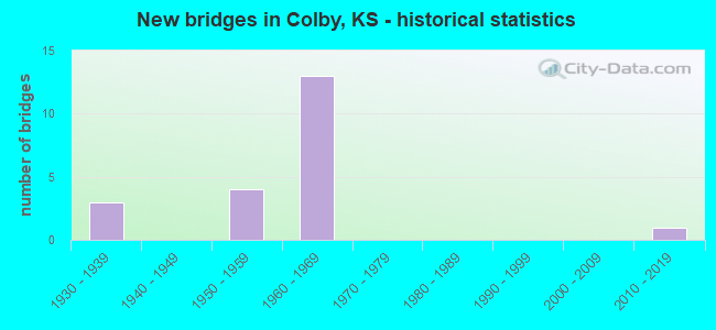
- New bridges - historical statistics
- 31930-1939
- 41950-1959
- 131960-1969
- 12010-2019

- Reconstructed bridges - Historical Statistics
- 11950-1959
- 01960-1969
- 01970-1979
- 11980-1989


- Bridge Condition - Deck
- 14.3%Very good
- 85.7%Good

- Bridge Condition - Superstructure
- 14.3%Very good
- 85.7%Good

- Bridge Condition - Substructure
- 28.6%Very good
- 71.4%Good

- Bridge Condition - Channel
- 36.4%Very good
- 54.5%Good
- 9.1%Satisfactory

- Bridge Condition - Culverts
- 40.0%Good
- 40.0%Satisfactory
- 20.0%Fair
Find on map >> Show street view
Structure Number: 505400970000001, Location: CITY OF COLBY (Lat: 39.386978, Lng: -101.049361), Route carried "on" structure: City street , Year Built: 1950, Status: Open, Structure Length: 1.10m (3.61ft), Average Daily Traffic: 1,650 (year 2014), Truck Traffic: 10%, Average Future Daily Traffic: 1,650 (year 2040), Design Load: H 20, Features Intersected: TRIB. TO PRAIRIE DOG CR., Facility Carried by Structure: PINE STREET
Minimum Vertical Clearance: 30.47m (99.97ft), Kilometerpoint: 0.000, Lanes on structure: 2, Owner: City or Municipal Highway Agency, Approaching Roadway Width: 10.4m (34.1ft), Skew: 3 degrees, Material/Design: Concrete, Design/Construction: Culvert, Number Of Spans In Main Unit: 3, Length of Maximum Span: 3.5m (11.5ft), Curb or Sidewalk Widths: Left: 4.5m (14.8ft), Right: 4.5m (14.8ft), Curb-To-Curb Width: 10.5m (34.4ft), Out-to-Out Width: 19.5m (64.0ft)
Condition: Channel: Good, Culverts: Satisfactory, Operating Rating: 32.7 metric tons, Method Used To Determine Operating Rating: Field evaluation and documented engineering judgment, Inventory Rating: 32.7 metric tons, Method Used To Determine Inventory Rating: Field evaluation and documented engineering judgment, Structural Evaluation: Equal to present minimum criteria, Deck Geometry: Equal to present minimum criteria, Waterway Adequacy: Equal to present desirable criteria, Approach Roadway Alignment: Equal to present desirable criteria, Designated Inspection Frequency: Every 24 months, Inspection Date: June 2020, Other Special Inspection Date: March 2021, Wearing Surface/Protective System: Wearing Surface: Bituminous
Find on map >> Show street view
Structure Number: 505400970000002, Location: CITY OF COLBY (Lat: 39.390803, Lng: -101.045833), Route carried "on" structure: City street , Year Built: 1950, Status: Open, Structure Length: 1.12m (3.67ft), Average Daily Traffic: 4,800 (year 2014), Truck Traffic: 10%, Average Future Daily Traffic: 4,950 (year 2040), Design Load: H 20, Features Intersected: TRIB. TO PRAIRIE DOG CR., Facility Carried by Structure: FRANKLIN STREET
Minimum Vertical Clearance: 30.47m (99.97ft), Kilometerpoint: 0.000, Lanes on structure: 2, Owner: City or Municipal Highway Agency, Approaching Roadway Width: 13.1m (43.0ft), Skew: 3 degrees, Material/Design: Concrete, Design/Construction: Culvert, Number Of Spans In Main Unit: 3, Length of Maximum Span: 3.5m (11.5ft)
Condition: Channel: Good, Culverts: Satisfactory, Operating Rating: 54.4 metric tons, Method Used To Determine Operating Rating: Load Factor (LF), Inventory Rating: 32.7 metric tons, Method Used To Determine Inventory Rating: Load Factor (LF), Structural Evaluation: Equal to present minimum criteria, Waterway Adequacy: Equal to present desirable criteria, Approach Roadway Alignment: Equal to present desirable criteria, Designated Inspection Frequency: Every 24 months, Inspection Date: June 2020, Wearing Surface/Protective System: Wearing Surface: Bituminous
Find on map >> Show street view
Structure Number: 505400970000003, Location: CITY OF COLBY (Lat: 39.399556, Lng: -101.036333), Route carried "on" structure: City street , Year Built: 1950, Status: Open, Structure Length: 1.30m (4.27ft), Average Daily Traffic: 1,465 (year 2014), Truck Traffic: 10%, Average Future Daily Traffic: 1,465 (year 2040), Design Load: H 20, Features Intersected: TRIB. TO PRAIRIE DOG CR., Facility Carried by Structure: COUNTRY CLUB DRIVE
Minimum Vertical Clearance: 30.47m (99.97ft), Kilometerpoint: 0.000, Lanes on structure: 2, Owner: City or Municipal Highway Agency, Approaching Roadway Width: 12.1m (39.7ft), Material/Design: Concrete, Design/Construction: Culvert, Number Of Spans In Main Unit: 5, Length of Maximum Span: 2.4m (7.9ft), Curb or Sidewalk Widths: Left: 1.4m (4.6ft), Right: 1.4m (4.6ft), Curb-To-Curb Width: 12.1m (39.7ft), Out-to-Out Width: 14.9m (48.9ft)
Condition: Channel: Good, Culverts: Satisfactory, Operating Rating: 32.7 metric tons, Method Used To Determine Operating Rating: Field evaluation and documented engineering judgment, Inventory Rating: 32.7 metric tons, Method Used To Determine Inventory Rating: Field evaluation and documented engineering judgment, Structural Evaluation: Equal to present minimum criteria, Deck Geometry: Equal to present minimum criteria, Waterway Adequacy: Equal to present desirable criteria, Approach Roadway Alignment: Equal to present desirable criteria, Designated Inspection Frequency: Every 24 months, Inspection Date: June 2020, Other Special Inspection Date: March 2021, Wearing Surface/Protective System: Wearing Surface: Bituminous
Find on map >> Show street view
Structure Number: 999902400970331, Location: 1.78 MI. WEST OF K-25 (Lat: 39.394167, Lng: -101.087500), Route carried "on" structure: US 24, Year Built: 1950, Status: Open, Structure Length: 0.63m (2.07ft), Average Daily Traffic: 2,075 (year 2020), Truck Traffic: 12%, Average Future Daily Traffic: 2,075 (year 2041), Design Load: H 20, Features Intersected: PRAIRIE DOG CREEK
Minimum Vertical Clearance: 30.47m (99.97ft), Kilometerpoint: 28.775, Lanes on structure: 2, Base Highway Network: Yes, Owner: State Highway Agency, Approaching Roadway Width: 9.1m (29.9ft), Material/Design: Concrete, Design/Construction: Culvert, Number Of Spans In Main Unit: 2, Length of Maximum Span: 3.0m (9.8ft), Curb-To-Curb Width: 9.1m (29.9ft), Out-to-Out Width: 13.0m (42.7ft)
Condition: Channel: Very good, Culverts: Good, Operating Rating: 31.3 metric tons, Method Used To Determine Operating Rating: Load Factor (LF), Inventory Rating: 18.8 metric tons, Method Used To Determine Inventory Rating: Load Factor (LF), Structural Evaluation: Somewhat better than minimum adequacy, Deck Geometry: Meets minimum limits, Waterway Adequacy: High priority of corrective action, Approach Roadway Alignment: Better than present minimum criteria, Length Of Structure Improvement: 2.08m (6.82ft), Designated Inspection Frequency: Every 24 months, Inspection Date: May 2020, Deck Structure Type: Concrete Cast-file-Place, Wearing Surface/Protective System: Wearing Surface: Bituminous
Find on map >> Show street view
Structure Number: 999902400970344, Location: 0.86 MI. EAST OF K-25 (Lat: 39.396944, Lng: -101.039167), Route carried "on" structure: US 24, Year Built: 1938, Year Reconstructed: 1964, Status: Open, Structure Length: 0.89m (2.92ft), Average Daily Traffic: 4,465 (year 2020), Truck Traffic: 8%, Average Future Daily Traffic: 5,236 (year 2041), Design Load: H 20, Features Intersected: PRAIRIE DOG CREEK DRG
Minimum Vertical Clearance: 30.47m (99.97ft), Kilometerpoint: 33.032, Lanes on structure: 4, Owner: State Highway Agency, Approaching Roadway Width: 15.5m (50.9ft), Material/Design: Concrete, Design/Construction: Culvert, Number Of Spans In Main Unit: 2, Length of Maximum Span: 4.3m (14.1ft), Curb-To-Curb Width: 15.5m (50.9ft), Out-to-Out Width: 22.7m (74.5ft)
Condition: Channel: Good, Culverts: Good, Operating Rating: 89.8 metric tons, Method Used To Determine Operating Rating: Load Factor (LF), Inventory Rating: 89.8 metric tons, Method Used To Determine Inventory Rating: Load Factor (LF), Structural Evaluation: Better than present minimum criteria, Deck Geometry: Meets minimum limits, Waterway Adequacy: Better than present minimum criteria, Approach Roadway Alignment: Equal to present desirable criteria, Length Of Structure Improvement: 2.91m (9.55ft), Designated Inspection Frequency: Every 24 months, Inspection Date: May 2020, Deck Structure Type: Concrete Cast-file-Place, Wearing Surface/Protective System: Wearing Surface: Bituminous
Find on map >> Show street view
Structure Number: 999902500970431, Location: 1.19 MI. NORTH OF I-70 (Lat: 39.381944, Lng: -101.054722), Route carried "on" structure: State highway 25, Year Built: 1965, Status: Open, Structure Length: 0.88m (2.89ft), Average Daily Traffic: 8,925 (year 2020), Truck Traffic: 6%, Average Future Daily Traffic: 9,861 (year 2041), Design Load: H 20, Features Intersected: PRAIRIE DOG CREEK DRG
Minimum Vertical Clearance: 30.47m (99.97ft), Kilometerpoint: 27.655, Lanes on structure: 5, Owner: State Highway Agency, Approaching Roadway Width: 14.6m (47.9ft), Material/Design: Concrete, Design/Construction: Culvert, Number Of Spans In Main Unit: 2, Length of Maximum Span: 4.3m (14.1ft), Curb-To-Curb Width: 20.4m (66.9ft), Out-to-Out Width: 26.7m (87.6ft)
Condition: Channel: Good, Culverts: Satisfactory, Operating Rating: 38.7 metric tons, Method Used To Determine Operating Rating: Load Factor (LF), Inventory Rating: 23.1 metric tons, Method Used To Determine Inventory Rating: Load Factor (LF), Structural Evaluation: Somewhat better than minimum adequacy, Deck Geometry: Somewhat better than minimum adequacy, Waterway Adequacy: High priority of corrective action, Approach Roadway Alignment: Better than present minimum criteria, Length Of Structure Improvement: 2.87m (9.42ft), Designated Inspection Frequency: Every 24 months, Inspection Date: May 2020, Deck Structure Type: Concrete Cast-file-Place, Wearing Surface/Protective System: Wearing Surface: Bituminous
Find on map >> Show street view
Structure Number: 999902500970451, Location: 0.82 MI. NORTH OF US-24 (Lat: 39.408889, Lng: -101.054444), Route carried "on" structure: State highway 25, Year Built: 1934, Status: Open, Structure Length: 1.60m (5.25ft), Average Daily Traffic: 2,205 (year 2020), Truck Traffic: 16%, Average Future Daily Traffic: 2,638 (year 2041), Design Load: H 15, Features Intersected: PRAIRIE DOG CREEK
Minimum Vertical Clearance: 30.47m (99.97ft), Kilometerpoint: 30.639, Lanes on structure: 2, Owner: State Highway Agency, Approaching Roadway Width: 7.3m (24.0ft), Material/Design: Concrete, Design/Construction: Culvert, Number Of Spans In Main Unit: 6, Length of Maximum Span: 2.4m (7.9ft), Curb-To-Curb Width: 7.9m (25.9ft), Out-to-Out Width: 10.5m (34.4ft)
Condition: Channel: Very good, Culverts: Good, Operating Rating: 32.8 metric tons, Method Used To Determine Operating Rating: Load Factor (LF), Inventory Rating: 19.7 metric tons, Method Used To Determine Inventory Rating: Load Factor (LF), Structural Evaluation: Somewhat better than minimum adequacy, Deck Geometry: High priority of corrective action, Waterway Adequacy: Meets minimum limits, Approach Roadway Alignment: Meets minimum limits, Length Of Structure Improvement: 5.25m (17.22ft), Designated Inspection Frequency: Every 24 months, Inspection Date: May 2020, Deck Structure Type: Concrete Cast-file-Place, Wearing Surface/Protective System: Wearing Surface: Bituminous
Find on map >> Show street view
Structure Number: 999902500970461, Location: 0.92 MI. NORTH OF US-24 (Lat: 39.410278, Lng: -101.054444), Route carried "on" structure: State highway 25, Year Built: 1934, Status: Open, Structure Length: 1.34m (4.40ft), Average Daily Traffic: 2,205 (year 2020), Truck Traffic: 16%, Average Future Daily Traffic: 2,638 (year 2041), Design Load: H 15, Features Intersected: PRAIRIE DOG CREEK DRG
Minimum Vertical Clearance: 30.47m (99.97ft), Kilometerpoint: 30.801, Lanes on structure: 2, Base Highway Network: Yes, Owner: State Highway Agency, Approaching Roadway Width: 7.3m (24.0ft), Material/Design: Concrete, Design/Construction: Culvert, Number Of Spans In Main Unit: 5, Length of Maximum Span: 2.4m (7.9ft), Curb-To-Curb Width: 9.8m (32.2ft), Out-to-Out Width: 10.5m (34.4ft)
Condition: Channel: Satisfactory, Culverts: Fair, Operating Rating: 32.8 metric tons, Method Used To Determine Operating Rating: Load Factor (LF), Inventory Rating: 19.7 metric tons, Method Used To Determine Inventory Rating: Load Factor (LF), Structural Evaluation: Somewhat better than minimum adequacy, Deck Geometry: Meets minimum limits, Waterway Adequacy: Meets minimum limits, Approach Roadway Alignment: Meets minimum limits, Length Of Structure Improvement: 4.38m (14.37ft), Designated Inspection Frequency: Every 24 months, Inspection Date: May 2020, Deck Structure Type: Concrete Cast-file-Place, Wearing Surface/Protective System: Wearing Surface: Bituminous
Find on map >> Show street view
Structure Number: 999902500970521, Location: 2.72 MI SOUTH OF I-70 (Lat: 39.325278, Lng: -101.055000), Route carried "on" structure: State highway 25, Year Built: 2012, Status: Open, Structure Length: 2.51m (8.23ft), Average Daily Traffic: 827 (year 2020), Truck Traffic: 18%, Average Future Daily Traffic: 1,009 (year 2041), Design Load: HL 93, Features Intersected: N FORK SOLOMON RIVER
Minimum Vertical Clearance: 30.47m (99.97ft), Kilometerpoint: 21.345, Lanes on structure: 2, Base Highway Network: Yes, Owner: State Highway Agency, Approaching Roadway Width: 11.0m (36.1ft), Material/Design: Concrete continuous, Design/Construction: Slab, Number Of Spans In Main Unit: 3, Length of Maximum Span: 9.8m (32.2ft), Curb-To-Curb Width: 11.0m (36.1ft), Out-to-Out Width: 11.6m (38.1ft)
Condition: Deck: Very good, Superstructure: Very good, Substructure: Very good, Channel: Very good, Operating Rating: 65.8 metric tons, Method Used To Determine Operating Rating: Load and Resistance Factor Rating (LRFR) rating reported by rating factor(RF) method using HL-93 loadings, Inventory Rating: 50.9 metric tons, Method Used To Determine Inventory Rating: Load and Resistance Factor Rating (LRFR) rating reported by rating factor(RF) method using HL-93 loadings, Structural Evaluation: Equal to present desirable criteria, Deck Geometry: Better than present minimum criteria, Waterway Adequacy: Equal to present desirable criteria, Approach Roadway Alignment: Better than present minimum criteria, Length Of Structure Improvement: 8.25m (27.07ft), Designated Inspection Frequency: Every 24 months, Inspection Date: May 2020, Wearing Surface/Protective System: Wearing Surface: Monolithic Concrete, Deck Protection: Epoxy Coated Reinforcing
Find on map >> Show street view
Structure Number: 999907000970161, Location: 1.13 MI WEST OF K-25 (Lat: 39.364722, Lng: -101.076389), Route carried "on" structure: Interstate 70, Year Built: 1966, Status: Open, Structure Length: 0.88m (2.89ft), Average Daily Traffic: 6,002 (year 2020), Truck Traffic: 30%, Average Future Daily Traffic: 8,575 (year 2041), Design Load: HS 20+Mod, Features Intersected: PRAIRIE DOG CR DRAIN
Minimum Vertical Clearance: 30.47m (99.97ft), Kilometerpoint: 28.194, Lanes on structure: 4, Base Highway Network: Yes, Owner: State Highway Agency, Approaching Roadway Width: 24.4m (80.1ft), Skew: 20 degrees, Material/Design: Concrete, Design/Construction: Culvert, Number Of Spans In Main Unit: 2, Length of Maximum Span: 4.3m (14.1ft), Curb-To-Curb Width: 24.4m (80.1ft), Out-to-Out Width: 39.5m (129.6ft)
Condition: Channel: Very good, Culverts: Fair, Operating Rating: 60.4 metric tons, Method Used To Determine Operating Rating: Load Factor (LF), Inventory Rating: 36.2 metric tons, Method Used To Determine Inventory Rating: Load Factor (LF), Structural Evaluation: Somewhat better than minimum adequacy, Deck Geometry: Superior to present desirable criteria, Waterway Adequacy: Equal to present desirable criteria, Approach Roadway Alignment: Equal to present desirable criteria, Length Of Structure Improvement: 2.88m (9.45ft), Designated Inspection Frequency: Every 24 months, Inspection Date: June 2020, Deck Structure Type: Concrete Cast-file-Place, Wearing Surface/Protective System: Wearing Surface: Bituminous
Find on map >> Show street view
Structure Number: 999907000970171, Location: JCT I-70 / K-25 (Lat: 39.364722, Lng: -101.054722), Route carried "on" structure: Interstate 70, Year Built: 1965, Status: Open, Structure Length: 5.20m (17.06ft), Average Daily Traffic: 6,002 (year 2020), Truck Traffic: 30%, Average Future Daily Traffic: 8,575 (year 2041), Design Load: HS 20+Mod, Features Intersected: K-25 HIGHWAY
Minimum Vertical Clearance: 30.47m (99.97ft), Kilometerpoint: 30.042, Lanes on structure: 2, Lanes under structure: 4, Base Highway Network: Yes, Owner: State Highway Agency, Approaching Roadway Width: 12.2m (40.0ft), Material/Design: Concrete continuous, Design/Construction: Slab, Number Of Spans In Main Unit: 4, Length of Maximum Span: 14.6m (47.9ft), Curb-To-Curb Width: 12.2m (40.0ft), Out-to-Out Width: 12.8m (42.0ft)
Condition: Deck: Good, Superstructure: Good, Substructure: Good, Operating Rating: 58.1 metric tons, Method Used To Determine Operating Rating: Load Factor (LF), Inventory Rating: 34.5 metric tons, Method Used To Determine Inventory Rating: Load Factor (LF), Structural Evaluation: Better than present minimum criteria, Deck Geometry: Better than present minimum criteria, Underclear: Equal to present minimum criteria, Approach Roadway Alignment: Equal to present desirable criteria, Length Of Structure Improvement: 17.05m (55.94ft), Designated Inspection Frequency: Every 24 months, Inspection Date: June 2020, Deck Structure Type: Concrete Cast-file-Place, Wearing Surface/Protective System: Wearing Surface: Low Slump Concrete
Find on map >> Show street view
Structure Number: 999907000970181, Location: JCT I-70 / K-25 (Lat: 39.364444, Lng: -101.054722), Route carried "on" structure: Interstate 70, Year Built: 1965, Status: Open, Structure Length: 5.20m (17.06ft), Average Daily Traffic: 6,002 (year 2020), Truck Traffic: 30%, Average Future Daily Traffic: 8,575 (year 2041), Design Load: HS 20+Mod, Features Intersected: K-25 HIGHWAY
Minimum Vertical Clearance: 30.47m (99.97ft), Kilometerpoint: 30.042, Lanes on structure: 2, Lanes under structure: 4, Base Highway Network: Yes, Owner: State Highway Agency, Approaching Roadway Width: 12.2m (40.0ft), Material/Design: Concrete continuous, Design/Construction: Slab, Number Of Spans In Main Unit: 4, Length of Maximum Span: 14.6m (47.9ft), Curb-To-Curb Width: 12.2m (40.0ft), Out-to-Out Width: 12.8m (42.0ft)
Condition: Deck: Good, Superstructure: Good, Substructure: Very good, Operating Rating: 58.1 metric tons, Method Used To Determine Operating Rating: Load Factor (LF), Inventory Rating: 34.5 metric tons, Method Used To Determine Inventory Rating: Load Factor (LF), Structural Evaluation: Better than present minimum criteria, Deck Geometry: Better than present minimum criteria, Underclear: Equal to present minimum criteria, Approach Roadway Alignment: Equal to present desirable criteria, Length Of Structure Improvement: 17.05m (55.94ft), Designated Inspection Frequency: Every 24 months, Inspection Date: June 2020, Deck Structure Type: Concrete Cast-file-Place, Wearing Surface/Protective System: Wearing Surface: Low Slump Concrete
Find on map >> Show street view
Structure Number: 999907000970191, Location: 1.00 MI EAST OF K-25 (Lat: 39.363611, Lng: -101.036389), Route carried "on" structure: County highway 554, Year Built: 1964, Year Reconstructed: 1986, Status: Open, Structure Length: 7.63m (25.03ft), Average Daily Traffic: 3,035 (year 2020), Average Future Daily Traffic: 4,877 (year 2041), Design Load: H 20, Features Intersected: I-70 HIGHWAY, Facility Carried by Structure: COUNTRY CLUB DR.
Minimum Vertical Clearance: 30.47m (99.97ft), Kilometerpoint: 0.098, Lanes on structure: 2, Lanes under structure: 4, Owner: State Highway Agency, Approaching Roadway Width: 8.5m (27.9ft), Material/Design: Concrete continuous, Design/Construction: Box Beam or Girders - Multiple, Number Of Spans In Main Unit: 4, Length of Maximum Span: 22.3m (73.2ft), Curb-To-Curb Width: 9.1m (29.9ft), Out-to-Out Width: 9.8m (32.2ft)
Condition: Deck: Good, Superstructure: Good, Substructure: Good, Operating Rating: 54.8 metric tons, Method Used To Determine Operating Rating: Load Factor (LF), Inventory Rating: 32.8 metric tons, Method Used To Determine Inventory Rating: Load Factor (LF), Structural Evaluation: Better than present minimum criteria, Deck Geometry: Meets minimum limits, Underclear: Somewhat better than minimum adequacy, Approach Roadway Alignment: Meets minimum limits, Length Of Structure Improvement: 25.05m (82.19ft), Designated Inspection Frequency: Every 24 months, Inspection Date: June 2020, Deck Structure Type: Concrete Cast-file-Place, Wearing Surface/Protective System: Wearing Surface: Low Slump Concrete
Find on map >> Show street view
Structure Number: 999907000970201, Location: 3.50 MI SE OF K-25 (Lat: 39.336389, Lng: -101.006944), Route carried "on" structure: Interstate 70, Year Built: 1965, Status: Open, Structure Length: 2.51m (8.23ft), Average Daily Traffic: 6,220 (year 2020), Truck Traffic: 34%, Average Future Daily Traffic: 8,887 (year 2041), Design Load: HS 20+Mod, Features Intersected: N FORK SOLOMON RIVER
Minimum Vertical Clearance: 30.47m (99.97ft), Kilometerpoint: 35.657, Lanes on structure: 4, Base Highway Network: Yes, Owner: State Highway Agency, Approaching Roadway Width: 24.4m (80.1ft), Skew: 20 degrees, Material/Design: Concrete, Design/Construction: Culvert, Number Of Spans In Main Unit: 4, Length of Maximum Span: 6.1m (20.0ft), Curb-To-Curb Width: 24.4m (80.1ft), Out-to-Out Width: 39.5m (129.6ft)
Condition: Channel: Good, Culverts: Good, Operating Rating: 26.3 metric tons, Method Used To Determine Operating Rating: Load Factor (LF), Inventory Rating: 15.4 metric tons, Method Used To Determine Inventory Rating: Load Factor (LF), Structural Evaluation: High priority of corrective action, Deck Geometry: Superior to present desirable criteria, Waterway Adequacy: Equal to present desirable criteria, Approach Roadway Alignment: Equal to present desirable criteria, Length Of Structure Improvement: 8.25m (27.07ft), Designated Inspection Frequency: Every 24 months, Inspection Date: June 2020, Deck Structure Type: Concrete Cast-file-Place, Wearing Surface/Protective System: Wearing Surface: Bituminous
Find on map >> Show street view
Structure Number: 999907000970211, Location: 4.76 MI SE OF K-25 (Lat: 39.321389, Lng: -100.993333), Route carried "on" structure: County highway 9704, Year Built: 1965, Status: Open, Structure Length: 9.10m (29.86ft), Average Daily Traffic: 70 (year 2020), Truck Traffic: 3%, Average Future Daily Traffic: 8,144 (year 2041), Design Load: H 15, Features Intersected: I-70 HIGHWAY, Facility Carried by Structure: LOCAL RD
Minimum Vertical Clearance: 30.47m (99.97ft), Kilometerpoint: 5.327, Lanes on structure: 2, Lanes under structure: 4, Owner: State Highway Agency, Approaching Roadway Width: 7.3m (24.0ft), Material/Design: Concrete continuous, Design/Construction: Box Beam or Girders - Multiple, Number Of Spans In Main Unit: 4, Length of Maximum Span: 25.6m (84.0ft), Curb-To-Curb Width: 7.3m (24.0ft), Out-to-Out Width: 9.0m (29.5ft)
Condition: Deck: Good, Superstructure: Good, Substructure: Good, Operating Rating: 52.3 metric tons, Method Used To Determine Operating Rating: Load Factor (LF), Inventory Rating: 31.3 metric tons, Method Used To Determine Inventory Rating: Load Factor (LF), Structural Evaluation: Better than present minimum criteria, Deck Geometry: Equal to present minimum criteria, Underclear: Somewhat better than minimum adequacy, Approach Roadway Alignment: Somewhat better than minimum adequacy, Length Of Structure Improvement: 29.85m (97.93ft), Designated Inspection Frequency: Every 24 months, Inspection Date: June 2020, Deck Structure Type: Concrete Cast-file-Place, Wearing Surface/Protective System: Wearing Surface: Monolithic Concrete
Find on map >> Show street view
Structure Number: 999907000970221, Location: 5.81 MI SE OF K-25 (Lat: 39.313333, Lng: -100.976944), Route carried "on" structure: Interstate 70, Year Built: 1965, Status: Open, Structure Length: 4.86m (15.94ft), Average Daily Traffic: 6,220 (year 2020), Truck Traffic: 34%, Average Future Daily Traffic: 8,887 (year 2041), Design Load: HS 20+Mod, Features Intersected: UNION PACIFIC RAILROAD
Minimum Vertical Clearance: 30.47m (99.97ft), Kilometerpoint: 39.381, Lanes on structure: 2, Base Highway Network: Yes, Owner: State Highway Agency, Approaching Roadway Width: 12.2m (40.0ft), Skew: 4 degrees, Material/Design: Concrete continuous, Design/Construction: Slab, Number Of Spans In Main Unit: 3, Length of Maximum Span: 18.3m (60.0ft), Curb-To-Curb Width: 12.2m (40.0ft), Out-to-Out Width: 12.8m (42.0ft)
Condition: Deck: Good, Superstructure: Good, Substructure: Good, Operating Rating: 49.9 metric tons, Method Used To Determine Operating Rating: Load Factor (LF), Inventory Rating: 29.9 metric tons, Method Used To Determine Inventory Rating: Load Factor (LF), Structural Evaluation: Better than present minimum criteria, Deck Geometry: Better than present minimum criteria, Underclear: Somewhat better than minimum adequacy, Approach Roadway Alignment: Equal to present desirable criteria, Length Of Structure Improvement: 15.94m (52.30ft), Designated Inspection Frequency: Every 24 months, Inspection Date: June 2020, Deck Structure Type: Concrete Cast-file-Place, Wearing Surface/Protective System: Wearing Surface: Epoxy Overlay
Find on map >> Show street view
Structure Number: 999907000970231, Location: 5.82 MI SE OF K-25 (Lat: 39.313056, Lng: -100.976944), Route carried "on" structure: Interstate 70, Year Built: 1965, Status: Open, Structure Length: 4.86m (15.94ft), Average Daily Traffic: 6,220 (year 2020), Truck Traffic: 34%, Average Future Daily Traffic: 8,887 (year 2041), Design Load: HS 20+Mod, Features Intersected: UNION PACIFIC RAILROAD
Minimum Vertical Clearance: 30.47m (99.97ft), Kilometerpoint: 39.394, Lanes on structure: 2, Base Highway Network: Yes, Owner: State Highway Agency, Approaching Roadway Width: 12.2m (40.0ft), Skew: 4 degrees, Material/Design: Concrete continuous, Design/Construction: Slab, Number Of Spans In Main Unit: 3, Length of Maximum Span: 18.3m (60.0ft), Curb-To-Curb Width: 12.2m (40.0ft), Out-to-Out Width: 12.8m (42.0ft)
Condition: Deck: Good, Superstructure: Good, Substructure: Good, Operating Rating: 49.9 metric tons, Method Used To Determine Operating Rating: Load Factor (LF), Inventory Rating: 29.9 metric tons, Method Used To Determine Inventory Rating: Load Factor (LF), Structural Evaluation: Better than present minimum criteria, Deck Geometry: Better than present minimum criteria, Underclear: Somewhat better than minimum adequacy, Approach Roadway Alignment: Equal to present desirable criteria, Length Of Structure Improvement: 15.94m (52.30ft), Designated Inspection Frequency: Every 24 months, Inspection Date: June 2020, Deck Structure Type: Concrete Cast-file-Place, Wearing Surface/Protective System: Wearing Surface: Epoxy Overlay
Find on map >> Show street view
Structure Number: 999907000970171, Location: JCT I-70 / K-25 (Lat: 39.364722, Lng: -101.054722), Route carried "under" structure: State highway 25, Year Built: 1965, Structure Length: 0. m, Average Daily Traffic: 3,767 (year 2020), Truck Traffic: 8%, Features Intersected: K-25 HIGHWAY, Facility Carried by Structure: I-70 HWY WESTBOUND
Minimum Vertical Clearance: 4.61m (15.12ft), Kilometerpoint: 25.748, Lanes on structure: 2, Lanes under structure: 4, Material/Design: Concrete continuous, Design/Construction: Slab, Length of Maximum Span: 14.6m (47.9ft)
Find on map >> Show street view
Structure Number: 999907000970181, Location: JCT I-70 / K-25 (Lat: 39.364444, Lng: -101.054722), Route carried "under" structure: State highway 25, Year Built: 1965, Structure Length: 0. m, Average Daily Traffic: 3,767 (year 2020), Truck Traffic: 8%, Features Intersected: K-25 HIGHWAY, Facility Carried by Structure: I-70 HWY EASTBOUND
Minimum Vertical Clearance: 4.80m (15.75ft), Kilometerpoint: 25.722, Lanes on structure: 2, Lanes under structure: 4, Material/Design: Concrete continuous, Design/Construction: Slab, Length of Maximum Span: 14.6m (47.9ft)
Find on map >> Show street view
Structure Number: 999907000970191, Location: 1.00 MI EAST OF K-25 (Lat: 39.363611, Lng: -101.036389), Route carried "under" structure: Interstate 70, Year Built: 1964, Structure Length: 0. m, Average Daily Traffic: 6,220 (year 2020), Truck Traffic: 34%, Features Intersected: I-70 HIGHWAY, Facility Carried by Structure: COUNTRY CLUB DR.
Minimum Vertical Clearance: 4.85m (15.91ft), Kilometerpoint: 31.632, Lanes on structure: 2, Lanes under structure: 4, Material/Design: Concrete continuous, Design/Construction: Box Beam or Girders - Multiple, Length of Maximum Span: 22.3m (73.2ft)
Find on map >> Show street view
Structure Number: 999907000970211, Location: 4.76 MI SE OF K-25 (Lat: 39.321389, Lng: -100.993333), Route carried "under" structure: Interstate 70, Year Built: 1965, Structure Length: 0. m, Average Daily Traffic: 6,220 (year 2020), Truck Traffic: 34%, Features Intersected: I-70 HIGHWAY, Facility Carried by Structure: LOCAL RD
Minimum Vertical Clearance: 4.86m (15.94ft), Kilometerpoint: 37.691, Lanes on structure: 2, Lanes under structure: 4, Material/Design: Concrete continuous, Design/Construction: Box Beam or Girders - Multiple, Length of Maximum Span: 25.6m (84.0ft)