Bridge Statistics for Colchester, Vermont (VT)
Condition, Traffic, Stress, Structural Evaluation, Project Costs
- National Bridge Inventory (NBI) Statistics
- 21Number of bridges
- 571ft / 174mTotal length
- $80,967,000Total costs
- 437,488Total average daily traffic
- 40,119Total average daily truck traffic
- National Bridge Inventory (NBI) Registered Bridges for Colchester
- No street view available for this location
- New bridges - historical statistics
- 171960-1969
- 11980-1989
- 11990-1999
- 12000-2009
- 12010-2019
- Reconstructed bridges - Historical Statistics
- 12000-2009
- 42010-2019
- Bridge Condition - Deck
- 41.7%Very good
- 33.3%Good
- 8.3%Satisfactory
- 8.3%Fair
- 8.3%Poor
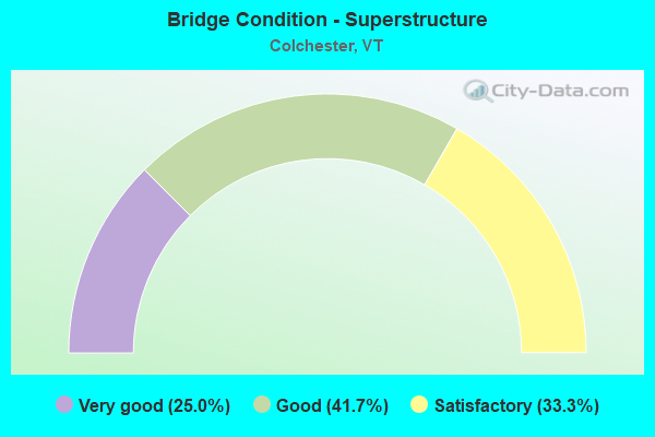
- Bridge Condition - Superstructure
- 25.0%Very good
- 41.7%Good
- 33.3%Satisfactory
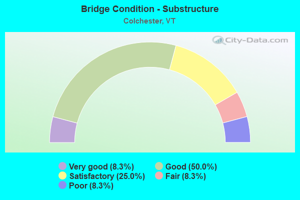
- Bridge Condition - Substructure
- 8.3%Very good
- 50.0%Good
- 25.0%Satisfactory
- 8.3%Fair
- 8.3%Poor
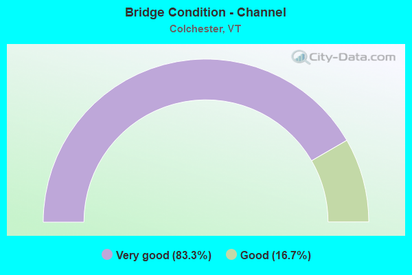
- Bridge Condition - Channel
- 83.3%Very good
- 16.7%Good
Find on map >> Show street view
Structure Number: 100405000304051, Location: 0.04 MI TO JCT US7 (Lat: 44.548347, Lng: -73.165678), Route carried "on" structure: Other road C2001, Year Built: 1992, Status: Open, Structure Length: 0.76m (2.49ft), Average Daily Traffic: 2,000 (year 2019), Truck Traffic: 2%, Average Future Daily Traffic: 2,100 (year 2029), Design Load: HS 20, Features Intersected: INDIAN BROOK
Minimum Vertical Clearance: 30+ m (98+ ft), Kilometerpoint: 0.000, Lanes on structure: 2, Owner: Town or Township Highway Agency, Approaching Roadway Width: 9.1m (29.9ft), Material/Design: Concrete, Design/Construction: Culvert, Number Of Spans In Main Unit: 1, Length of Maximum Span: 7.3m (24.0ft)
Condition: Channel: Good, Culverts: Good, Operating Rating: 54.4 metric tons, Method Used To Determine Operating Rating: Field evaluation and documented engineering judgment, Inventory Rating: 32.7 metric tons, Method Used To Determine Inventory Rating: Field evaluation and documented engineering judgment, Structural Evaluation: Better than present minimum criteria, Waterway Adequacy: Equal to present desirable criteria, Approach Roadway Alignment: Equal to present desirable criteria, Designated Inspection Frequency: Every 24 months, Inspection Date: September 2021
Find on map >> Show street view
Structure Number: 100405001404051, Location: 0.16 MI TO JCT W C3 TH17 (Lat: 44.548878, Lng: -73.124758), Route carried "on" structure: Other road C3015, Year Built: 1960, Year Reconstructed: 2011, Status: Open, Structure Length: 1.16m (3.81ft), Average Daily Traffic: 75 (year 2019), Truck Traffic: 2%, Average Future Daily Traffic: 79 (year 2029), Features Intersected: COLCHESTER POND BRK.
Minimum Vertical Clearance: 30+ m (98+ ft), Kilometerpoint: 0.000, Lanes on structure: 1, Owner: Town or Township Highway Agency, Approaching Roadway Width: 5.5m (18.0ft), Material/Design: Steel, Design/Construction: Stringer/Multi-beam, Number Of Spans In Main Unit: 1, Length of Maximum Span: 10.4m (34.1ft), Curb-To-Curb Width: 4.3m (14.1ft), Out-to-Out Width: 4.3m (14.1ft)
Condition: Deck: Good, Superstructure: Good, Substructure: Satisfactory, Channel: Very good, Operating Rating: 68.0 metric tons, Method Used To Determine Operating Rating: Allowable Stress (AS), Inventory Rating: 47.2 metric tons, Method Used To Determine Inventory Rating: Allowable Stress (AS), Structural Evaluation: Equal to present minimum criteria, Deck Geometry: Equal to present minimum criteria, Waterway Adequacy: Better than present minimum criteria, Approach Roadway Alignment: Meets minimum limits, Length Of Structure Improvement: 1.16m (3.81ft), Designated Inspection Frequency: Every 24 months, Inspection Date: September 2021, Bridge Improvement Cost: $186,000, Roadway Improvement Cost: $50,000, Total Project Cost: $236,000 ( Estimate for 2020), Deck Structure Type: Corrugated Steel, Wearing Surface/Protective System: Wearing Surface: Bituminous
Find on map >> Show street view
Structure Number: 200028000107012, Location: 6.2 W JCT VT 78 (Lat: 44.998289, Lng: -73.344289), Route carried "on" structure: US 2, Year Built: 1987, Status: Open, Structure Length: 123.50m (405.18ft), Average Daily Traffic: 4,200 (year 2018), Truck Traffic: 10%, Average Future Daily Traffic: 4,410 (year 2028), Design Load: HS 20+Mod, Features Intersected: LAKE CHAMPLAIN
Minimum Vertical Clearance: 30+ m (98+ ft), Kilometerpoint: 0.002, Lanes on structure: 2, Base Highway Network: Yes, Owner: State Highway Agency, Approaching Roadway Width: 12.2m (40.0ft), Material/Design: Steel continuous, Design/Construction: Stringer/Multi-beam, Number Of Spans In Main Unit: 29, Length of Maximum Span: 76.2m (250.0ft), Curb-To-Curb Width: 12.0m (39.4ft), Out-to-Out Width: 13.0m (42.7ft)
Condition: Deck: Good, Superstructure: Very good, Substructure: Good, Channel: Very good, Operating Rating: 68.9 metric tons, Method Used To Determine Operating Rating: Allowable Stress (AS), Inventory Rating: 40.8 metric tons, Method Used To Determine Inventory Rating: Allowable Stress (AS), Structural Evaluation: Better than present minimum criteria, Deck Geometry: Somewhat better than minimum adequacy, Waterway Adequacy: Equal to present desirable criteria, Approach Roadway Alignment: Equal to present desirable criteria, Length Of Structure Improvement: 123.50m (405.18ft), Designated Inspection Frequency: Every 24 months, Underwater Inspection Frequency: Every 48 months, Inspection Date: July 2021, Underwater Inspection Date: August 2019, Bridge Improvement Cost: $60,699,000, Roadway Improvement Cost: $50,000, Total Project Cost: $60,749,000 ( Estimate for 2020), Deck Structure Type: Concrete Cast-file-Place, Wearing Surface/Protective System: Wearing Surface: Bituminous, Membrane: Preformed Fabric, Deck Protection: Epoxy Coated Reinforcing
Find on map >> Show street view
Structure Number: 200028018A04052, Location: 0.3 MI W JCT US 7 I89 E17 (Lat: 44.589961, Lng: -73.170297), Route carried "on" structure: US 2, Year Built: 1964, Status: Temporarily open, Structure Length: 7.19m (23.59ft), Average Daily Traffic: 17,800 (year 2018), Truck Traffic: 9%, Average Future Daily Traffic: 18,690 (year 2028), Design Load: HS 20, Features Intersected: I 89 UNDER US 2
Minimum Vertical Clearance: 30+ m (98+ ft), Kilometerpoint: 62.469, Lanes on structure: 2, Lanes under structure: 5, Base Highway Network: Yes, Owner: State Highway Agency, Approaching Roadway Width: 14.0m (45.9ft), Skew: 1 degrees, Material/Design: Steel, Design/Construction: Stringer/Multi-beam, Number Of Spans In Main Unit: 4, Length of Maximum Span: 21.9m (71.9ft), Curb or Sidewalk Widths: Left: 0.5m (1.6ft), Right: 0.5m (1.6ft), Curb-To-Curb Width: 12.8m (42.0ft), Out-to-Out Width: 14.3m (46.9ft)
Condition: Deck: Poor, Superstructure: Satisfactory, Substructure: Poor, Operating Rating: 65.3 metric tons, Method Used To Determine Operating Rating: Load Factor (LF), Inventory Rating: 39.0 metric tons, Method Used To Determine Inventory Rating: Load Factor (LF), Structural Evaluation: Meets minimum limits, Deck Geometry: Somewhat better than minimum adequacy, Underclear: Somewhat better than minimum adequacy, Approach Roadway Alignment: Equal to present desirable criteria, Length Of Structure Improvement: 7.19m (23.59ft), Designated Inspection Frequency: Every 12 months, Inspection Date: April 2021, Bridge Improvement Cost: $3,882,000, Roadway Improvement Cost: $50,000, Total Project Cost: $3,932,000 ( Estimate for 2020), Deck Structure Type: Concrete Cast-file-Place, Wearing Surface/Protective System: Wearing Surface: Bituminous, Membrane: Other
Find on map >> Show street view
Structure Number: 200089000214082, Location: 0.2 MI S I 89-I 91 INTERS (Lat: 43.635244, Lng: -72.330564), Route carried "on" structure: Interstate 89, Year Built: 1965, Status: Open, Structure Length: 0.64m (2.10ft), Average Daily Traffic: 42,000 (year 2018), Truck Traffic: 13%, Average Future Daily Traffic: 44,100 (year 2028), Design Load: H 20, Features Intersected: I 89 OVER TH NO 78
Minimum Vertical Clearance: 30+ m (98+ ft), Kilometerpoint: 0.097, Lanes on structure: 4, Lanes under structure: 2, Base Highway Network: Yes, Owner: State Highway Agency, Approaching Roadway Width: 23.2m (76.1ft), Skew: 10 degrees, Material/Design: Concrete, Design/Construction: Frame, Number Of Spans In Main Unit: 1, Length of Maximum Span: 6.4m (21.0ft), Curb-To-Curb Width: 11.6m (38.1ft), Out-to-Out Width: 11.6m (38.1ft)
Condition: Deck: Good, Superstructure: Good, Substructure: Good, Operating Rating: 37.2 metric tons, Method Used To Determine Operating Rating: Field evaluation and documented engineering judgment, Inventory Rating: 22.7 metric tons, Method Used To Determine Inventory Rating: Field evaluation and documented engineering judgment, Structural Evaluation: Somewhat better than minimum adequacy, Deck Geometry: High priority of replacement, Underclear: High priority of corrective action, Approach Roadway Alignment: Equal to present desirable criteria, Length Of Structure Improvement: 0.64m (2.10ft), Designated Inspection Frequency: Every 24 months, Inspection Date: May 2020, Bridge Improvement Cost: $279,000, Roadway Improvement Cost: $50,000, Total Project Cost: $329,000 ( Estimate for 2020)
Find on map >> Show street view
Structure Number: 200089007804052, Location: 1.1 MI S EXIT 17 (Lat: 44.574808, Lng: -73.177286), Route carried "on" structure: Interstate 89, Year Built: 1964, Status: Open, Structure Length: 0.64m (2.10ft), Average Daily Traffic: 32,600 (year 2018), Truck Traffic: 13%, Average Future Daily Traffic: 34,230 (year 2028), Design Load: H 20, Features Intersected: I 89 OVER CAMP ROAD
Minimum Vertical Clearance: 30+ m (98+ ft), Kilometerpoint: 155.703, Lanes on structure: 4, Lanes under structure: 2, Base Highway Network: Yes, Owner: State Highway Agency, Approaching Roadway Width: 23.2m (76.1ft), Skew: 10 degrees, Material/Design: Concrete, Design/Construction: Culvert, Number Of Spans In Main Unit: 1, Length of Maximum Span: 6.4m (21.0ft)
Condition: Culverts: Good, Operating Rating: 37.2 metric tons, Method Used To Determine Operating Rating: Field evaluation and documented engineering judgment, Inventory Rating: 22.7 metric tons, Method Used To Determine Inventory Rating: Field evaluation and documented engineering judgment, Structural Evaluation: Somewhat better than minimum adequacy, Underclear: High priority of corrective action, Approach Roadway Alignment: Equal to present desirable criteria, Length Of Structure Improvement: 0.64m (2.10ft), Designated Inspection Frequency: Every 24 months, Inspection Date: June 2020, Bridge Improvement Cost: $559,000, Roadway Improvement Cost: $50,000, Total Project Cost: $609,000 ( Estimate for 2020)
Find on map >> Show street view
Structure Number: 200089074N04052, Location: I 89 EXIT 16 (Lat: 44.505692, Lng: -73.181103), Route carried "on" structure: Interstate 89, Year Built: 1963, Status: Open, Structure Length: 4.63m (15.19ft), Average Daily Traffic: 39,500 (year 2018), Truck Traffic: 8%, Average Future Daily Traffic: 41,475 (year 2028), Design Load: HS 20, Features Intersected: I 89 OVER US 7
Minimum Vertical Clearance: 30+ m (98+ ft), Kilometerpoint: 147.207, Lanes on structure: 2, Lanes under structure: 2, Base Highway Network: Yes, Owner: State Highway Agency, Approaching Roadway Width: 11.3m (37.1ft), Skew: 11 degrees, Material/Design: Steel, Design/Construction: Stringer/Multi-beam, Number Of Spans In Main Unit: 3, Length of Maximum Span: 23.5m (77.1ft), Curb or Sidewalk Widths: Left: 0.2m (0.7ft), Right: 0.2m (0.7ft), Curb-To-Curb Width: 9.1m (29.9ft), Out-to-Out Width: 10.7m (35.1ft)
Condition: Deck: Good, Superstructure: Very good, Substructure: Satisfactory, Operating Rating: 63.5 metric tons, Method Used To Determine Operating Rating: Load Factor (LF), Inventory Rating: 38.1 metric tons, Method Used To Determine Inventory Rating: Load Factor (LF), Structural Evaluation: Equal to present minimum criteria, Deck Geometry: High priority of replacement, Underclear: High priority of corrective action, Approach Roadway Alignment: Equal to present desirable criteria, Length Of Structure Improvement: 4.63m (15.19ft), Designated Inspection Frequency: Every 24 months, Inspection Date: June 2020, Bridge Improvement Cost: $1,862,000, Roadway Improvement Cost: $50,000, Total Project Cost: $1,912,000 ( Estimate for 2020), Deck Structure Type: Concrete Cast-file-Place, Wearing Surface/Protective System: Wearing Surface: Bituminous, Membrane: Preformed Fabric
Find on map >> Show street view
Structure Number: 200089074S04052, Location: I 89 EXIT 16 (Lat: 44.505506, Lng: -73.181183), Route carried "on" structure: Interstate 89, Year Built: 1963, Status: Open, Structure Length: 4.63m (15.19ft), Average Daily Traffic: 39,500 (year 2018), Truck Traffic: 8%, Average Future Daily Traffic: 41,475 (year 2028), Design Load: HS 20, Features Intersected: I 89 OVER US 7
Minimum Vertical Clearance: 30+ m (98+ ft), Kilometerpoint: 147.207, Lanes on structure: 2, Lanes under structure: 2, Base Highway Network: Yes, Owner: State Highway Agency, Approaching Roadway Width: 11.3m (37.1ft), Skew: 11 degrees, Material/Design: Steel, Design/Construction: Stringer/Multi-beam, Number Of Spans In Main Unit: 3, Length of Maximum Span: 23.5m (77.1ft), Curb or Sidewalk Widths: Left: 0.2m (0.7ft), Right: 0.2m (0.7ft), Curb-To-Curb Width: 9.1m (29.9ft), Out-to-Out Width: 10.7m (35.1ft)
Condition: Deck: Satisfactory, Superstructure: Good, Substructure: Satisfactory, Operating Rating: 63.5 metric tons, Method Used To Determine Operating Rating: Load Factor (LF), Inventory Rating: 38.1 metric tons, Method Used To Determine Inventory Rating: Load Factor (LF), Structural Evaluation: Equal to present minimum criteria, Deck Geometry: High priority of replacement, Underclear: High priority of corrective action, Approach Roadway Alignment: Equal to present desirable criteria, Length Of Structure Improvement: 4.63m (15.19ft), Designated Inspection Frequency: Every 24 months, Inspection Date: June 2020, Bridge Improvement Cost: $1,862,000, Roadway Improvement Cost: $50,000, Total Project Cost: $1,912,000 ( Estimate for 2020), Deck Structure Type: Concrete Cast-file-Place, Wearing Surface/Protective System: Wearing Surface: Bituminous, Membrane: Preformed Fabric
Find on map >> Show street view
Structure Number: 200089076N04052, Location: 2.6 MI S EXIT 17 (Lat: 44.554475, Lng: -73.184472), Route carried "on" structure: Interstate 89, Year Built: 1964, Year Reconstructed: 2019, Status: Open, Structure Length: 4.79m (15.72ft), Average Daily Traffic: 32,600 (year 2018), Truck Traffic: 6%, Average Future Daily Traffic: 34,230 (year 2028), Design Load: HL 93, Features Intersected: I 89 OVER TH NO 1
Minimum Vertical Clearance: 30+ m (98+ ft), Kilometerpoint: 153.354, Lanes on structure: 2, Lanes under structure: 2, Base Highway Network: Yes, Owner: State Highway Agency, Approaching Roadway Width: 11.0m (36.1ft), Skew: 11 degrees, Material/Design: Steel continuous, Design/Construction: Stringer/Multi-beam, Number Of Spans In Main Unit: 3, Length of Maximum Span: 20.7m (67.9ft), Curb-To-Curb Width: 9.4m (30.8ft), Out-to-Out Width: 10.6m (34.8ft)
Condition: Deck: Very good, Superstructure: Good, Substructure: Good, Operating Rating: 52.6 metric tons, Method Used To Determine Operating Rating: Load and Resistance Factor (LRFR), Inventory Rating: 40.8 metric tons, Method Used To Determine Inventory Rating: Load and Resistance Factor (LRFR), Structural Evaluation: Better than present minimum criteria, Deck Geometry: High priority of replacement, Underclear: Equal to present minimum criteria, Approach Roadway Alignment: Equal to present desirable criteria, Length Of Structure Improvement: 4.79m (15.72ft), Designated Inspection Frequency: Every 24 months, Inspection Date: June 2020, Bridge Improvement Cost: $1,912,000, Roadway Improvement Cost: $50,000, Total Project Cost: $1,962,000 ( Estimate for 2020), Deck Structure Type: Concrete Precast Panels, Wearing Surface/Protective System: Wearing Surface: Bituminous, Membrane: Other, Deck Protection: Epoxy Coated Reinforcing
Find on map >> Show street view
Structure Number: 200089076S04052, Location: 2.6 MI S EXIT 17 (Lat: 44.554497, Lng: -73.184775), Route carried "on" structure: Interstate 89, Year Built: 1964, Year Reconstructed: 2019, Status: Open, Structure Length: 4.79m (15.72ft), Average Daily Traffic: 32,600 (year 2018), Truck Traffic: 8%, Average Future Daily Traffic: 34,230 (year 2028), Design Load: HL 93, Features Intersected: I 89 OVER TH NO 1
Minimum Vertical Clearance: 30+ m (98+ ft), Kilometerpoint: 153.354, Lanes on structure: 2, Lanes under structure: 2, Base Highway Network: Yes, Owner: State Highway Agency, Approaching Roadway Width: 11.0m (36.1ft), Skew: 11 degrees, Material/Design: Steel continuous, Design/Construction: Stringer/Multi-beam, Number Of Spans In Main Unit: 3, Length of Maximum Span: 20.7m (67.9ft), Curb-To-Curb Width: 9.4m (30.8ft), Out-to-Out Width: 10.6m (34.8ft)
Condition: Deck: Very good, Superstructure: Satisfactory, Substructure: Good, Operating Rating: 52.6 metric tons, Method Used To Determine Operating Rating: Load and Resistance Factor (LRFR), Inventory Rating: 40.8 metric tons, Method Used To Determine Inventory Rating: Load and Resistance Factor (LRFR), Structural Evaluation: Equal to present minimum criteria, Deck Geometry: High priority of replacement, Underclear: Equal to present minimum criteria, Approach Roadway Alignment: Equal to present desirable criteria, Length Of Structure Improvement: 4.79m (15.72ft), Designated Inspection Frequency: Every 24 months, Inspection Date: June 2020, Bridge Improvement Cost: $1,912,000, Roadway Improvement Cost: $50,000, Total Project Cost: $1,962,000 ( Estimate for 2020), Deck Structure Type: Concrete Precast Panels, Wearing Surface/Protective System: Wearing Surface: Bituminous, Membrane: Other, Deck Protection: Epoxy Coated Reinforcing
Find on map >> Show street view
Structure Number: 200089077N04052, Location: 1.3 MI S EXIT 17 (Lat: 44.571756, Lng: -73.177731), Route carried "on" structure: Interstate 89, Year Built: 1964, Year Reconstructed: 2019, Status: Open, Structure Length: 5.70m (18.70ft), Average Daily Traffic: 32,600 (year 2018), Truck Traffic: 13%, Average Future Daily Traffic: 34,230 (year 2028), Design Load: HL 93, Features Intersected: MALLETT'S CREEK
Minimum Vertical Clearance: 30+ m (98+ ft), Kilometerpoint: 155.381, Lanes on structure: 2, Base Highway Network: Yes, Owner: State Highway Agency, Approaching Roadway Width: 11.6m (38.1ft), Skew: 10 degrees, Material/Design: Steel continuous, Design/Construction: Stringer/Multi-beam, Length of Maximum Span: 25.9m (85.0ft), Curb-To-Curb Width: 9.4m (30.8ft), Out-to-Out Width: 10.6m (34.8ft)
Condition: Deck: Very good, Superstructure: Good, Substructure: Good, Channel: Very good, Operating Rating: 63.5 metric tons, Method Used To Determine Operating Rating: Load and Resistance Factor (LRFR), Inventory Rating: 49.0 metric tons, Method Used To Determine Inventory Rating: Load and Resistance Factor (LRFR), Structural Evaluation: Better than present minimum criteria, Deck Geometry: High priority of replacement, Waterway Adequacy: Equal to present desirable criteria, Approach Roadway Alignment: Equal to present desirable criteria, Length Of Structure Improvement: 5.70m (18.70ft), Designated Inspection Frequency: Every 24 months, Underwater Inspection Frequency: Every 48 months, Inspection Date: June 2020, Underwater Inspection Date: August 2020, Bridge Improvement Cost: $2,278,000, Roadway Improvement Cost: $50,000, Total Project Cost: $2,328,000 ( Estimate for 2020), Deck Structure Type: Concrete Precast Panels, Wearing Surface/Protective System: Wearing Surface: Bituminous, Membrane: Other, Deck Protection: Epoxy Coated Reinforcing
Find on map >> Show street view
Structure Number: 200089077S04052, Location: 1.3 MI S EXIT 17 (Lat: 44.571750, Lng: -73.178019), Route carried "on" structure: Interstate 89, Year Built: 1964, Year Reconstructed: 2019, Status: Open, Structure Length: 5.70m (18.70ft), Average Daily Traffic: 32,600 (year 2018), Truck Traffic: 13%, Average Future Daily Traffic: 34,230 (year 2028), Design Load: HL 93, Features Intersected: MALLETT'S CREEK
Minimum Vertical Clearance: 30+ m (98+ ft), Kilometerpoint: 155.381, Lanes on structure: 2, Base Highway Network: Yes, Owner: State Highway Agency, Approaching Roadway Width: 11.6m (38.1ft), Skew: 10 degrees, Material/Design: Steel continuous, Design/Construction: Stringer/Multi-beam, Length of Maximum Span: 25.9m (85.0ft), Curb-To-Curb Width: 9.4m (30.8ft), Out-to-Out Width: 10.6m (34.8ft)
Condition: Deck: Very good, Superstructure: Satisfactory, Substructure: Good, Channel: Very good, Operating Rating: 63.5 metric tons, Method Used To Determine Operating Rating: Load and Resistance Factor (LRFR), Inventory Rating: 49.0 metric tons, Method Used To Determine Inventory Rating: Load and Resistance Factor (LRFR), Structural Evaluation: Equal to present minimum criteria, Deck Geometry: High priority of replacement, Waterway Adequacy: Equal to present desirable criteria, Approach Roadway Alignment: Equal to present desirable criteria, Length Of Structure Improvement: 5.70m (18.70ft), Designated Inspection Frequency: Every 24 months, Underwater Inspection Frequency: Every 48 months, Inspection Date: June 2020, Underwater Inspection Date: August 2020, Bridge Improvement Cost: $2,278,000, Roadway Improvement Cost: $50,000, Total Project Cost: $2,328,000 ( Estimate for 2020), Deck Structure Type: Concrete Precast Panels, Wearing Surface/Protective System: Wearing Surface: Bituminous, Membrane: Other, Deck Protection: Epoxy Coated Reinforcing
Find on map >> Show street view
Structure Number: 2004050D7504051, Location: 2.0 MI N EXIT 16 (Lat: 44.530372, Lng: -73.195150), Route carried "on" structure: County highway TH9, Year Built: 1964, Status: Temporarily open, Structure Length: 7.96m (26.12ft), Average Daily Traffic: 8,200 (year 2019), Truck Traffic: 2%, Average Future Daily Traffic: 8,610 (year 2029), Design Load: H 15, Features Intersected: TH NO 9 OVER I 89
Minimum Vertical Clearance: 30+ m (98+ ft), Kilometerpoint: 0.000, Lanes on structure: 2, Lanes under structure: 4, Owner: State Highway Agency, Approaching Roadway Width: 8.8m (28.9ft), Skew: 3 degrees, Material/Design: Steel, Design/Construction: Stringer/Multi-beam, Number Of Spans In Main Unit: 4, Length of Maximum Span: 26.5m (86.9ft), Curb or Sidewalk Widths: Left: 0.5m (1.6ft), Right: 0.5m (1.6ft), Curb-To-Curb Width: 7.3m (24.0ft), Out-to-Out Width: 8.9m (29.2ft)
Condition: Deck: Fair, Superstructure: Satisfactory, Substructure: Fair, Operating Rating: 44.5 metric tons, Method Used To Determine Operating Rating: Load Factor (LF), Inventory Rating: 26.3 metric tons, Method Used To Determine Inventory Rating: Load Factor (LF), Structural Evaluation: Somewhat better than minimum adequacy, Deck Geometry: High priority of replacement, Underclear: Somewhat better than minimum adequacy, Approach Roadway Alignment: Equal to present desirable criteria, Length Of Structure Improvement: 7.96m (26.12ft), Designated Inspection Frequency: Every 24 months, Inspection Date: June 2020, Bridge Improvement Cost: $2,658,000, Roadway Improvement Cost: $50,000, Total Project Cost: $2,708,000 ( Estimate for 2020), Deck Structure Type: Concrete Cast-file-Place, Wearing Surface/Protective System: Wearing Surface: Bituminous, Membrane: Other
Find on map >> Show street view
Structure Number: 205614001204052, Location: 0.24 MI TO JCT W VT2A (Lat: 44.541881, Lng: -73.152639), Route carried "on" structure: City street MILLP, Year Built: 2015, Status: Open, Structure Length: 2.26m (7.41ft), Average Daily Traffic: 2,300 (year 2015), Truck Traffic: 3%, Average Future Daily Traffic: 2,415 (year 2025), Design Load: HL 93, Features Intersected: INDIAN BROOK, Facility Carried by Structure: MILL POND RD TH27
Minimum Vertical Clearance: 30+ m (98+ ft), Kilometerpoint: 0.000, Lanes on structure: 2, Owner: Town or Township Highway Agency, Approaching Roadway Width: 9.8m (32.2ft), Material/Design: Steel, Design/Construction: Stringer/Multi-beam, Number Of Spans In Main Unit: 1, Length of Maximum Span: 21.9m (71.9ft), Curb or Sidewalk Widths: Left: 1.7m (5.6ft), Right: 0.0m, Curb-To-Curb Width: 10.2m (33.5ft), Out-to-Out Width: 10.9m (35.8ft)
Condition: Deck: Very good, Superstructure: Very good, Substructure: Very good, Channel: Very good, Operating Rating: 52.6 metric tons, Method Used To Determine Operating Rating: Load and Resistance Factor (LRFR), Inventory Rating: 40.8 metric tons, Method Used To Determine Inventory Rating: Load and Resistance Factor (LRFR), Structural Evaluation: Equal to present desirable criteria, Deck Geometry: Meets minimum limits, Waterway Adequacy: Equal to present desirable criteria, Approach Roadway Alignment: Equal to present desirable criteria, Designated Inspection Frequency: Every 24 months, Inspection Date: July 2020, Deck Structure Type: Concrete Cast-file-Place, Wearing Surface/Protective System: Deck Protection: Other Coated Reinforcing
Find on map >> Show street view
Structure Number: 200028018A04052, Location: 0.3 MI W JCT US 7 I89 E17 (Lat: 44.589961, Lng: -73.170297), Route carried "under" structure: Interstate 89, Year Built: 1964, Structure Length: 0. m, Average Daily Traffic: 23,133 (year 1998), Truck Traffic: 13%, Features Intersected: I 89 UNDER US 2, Facility Carried by Structure: US 00002 ML
Minimum Vertical Clearance: 5.81m (19.06ft), Kilometerpoint: 253.433, Lanes on structure: 3, Material/Design: Steel, Design/Construction: Stringer/Multi-beam, Length of Maximum Span: 21.9m (71.9ft)
Find on map >> Show street view
Structure Number: 200089074N04052, Location: I 89 EXIT 16 (Lat: 44.505692, Lng: -73.181103), Route carried "under" structure: US 7, Year Built: 1963, Structure Length: 0. m, Average Daily Traffic: 18,000 (year 1998), Truck Traffic: 9%, Features Intersected: I 89 OVER U.S.7, Facility Carried by Structure: I 00089 ML
Minimum Vertical Clearance: 5.28m (17.32ft), Kilometerpoint: 219.390, Lanes on structure: 4, Material/Design: Steel, Design/Construction: Stringer/Multi-beam, Length of Maximum Span: 23.5m (77.1ft)
Find on map >> Show street view
Structure Number: 200089074S04052, Location: I 89 EXIT 16 (Lat: 44.505506, Lng: -73.181183), Route carried "under" structure: US 7, Year Built: 1963, Structure Length: 0. m, Average Daily Traffic: 18,000 (year 1998), Truck Traffic: 9%, Features Intersected: I 89 OVER U.S.7, Facility Carried by Structure: I 00089 ML
Minimum Vertical Clearance: 5.53m (18.14ft), Kilometerpoint: 219.390, Lanes on structure: 4, Material/Design: Steel, Design/Construction: Stringer/Multi-beam, Length of Maximum Span: 23.5m (77.1ft)
Find on map >> Show street view
Structure Number: 200089076N04052, Location: 2.6 MI S EXIT 17 (Lat: 44.554475, Lng: -73.184472), Route carried "under" structure: County highway 1, Year Built: 1964, Structure Length: 0. m, Average Daily Traffic: 3,190 (year 1995), Truck Traffic: 6%, Features Intersected: I 89 OVER TH NO 1, Facility Carried by Structure: I 00089 ML
Minimum Vertical Clearance: 5.28m (17.32ft), Kilometerpoint: 0.000, Lanes on structure: 2, Material/Design: Steel continuous, Design/Construction: Stringer/Multi-beam, Length of Maximum Span: 20.7m (67.9ft)
Find on map >> Show street view
Structure Number: 200089076S04052, Location: 2.6 MI S EXIT 17 (Lat: 44.554497, Lng: -73.184775), Route carried "under" structure: County highway 1, Year Built: 1964, Structure Length: 0. m, Average Daily Traffic: 3,190 (year 1995), Truck Traffic: 6%, Features Intersected: I 89 OVER TH NO 1, Facility Carried by Structure: I 00089 ML
Minimum Vertical Clearance: 6.22m (20.41ft), Kilometerpoint: 0.000, Lanes on structure: 2, Material/Design: Steel continuous, Design/Construction: Stringer/Multi-beam, Length of Maximum Span: 20.7m (67.9ft)
Find on map >> Show street view
Structure Number: 20008974-204052, Location: 2.0 MI N EXIT 16 (Lat: 44.530303, Lng: -73.195064), Route carried "under" structure: Interstate 89, Year Built: 2003, Structure Length: 0. m, Average Daily Traffic: 26,700 (year 1998), Features Intersected: PED BRG OVER I89, Facility Carried by Structure: PEDESTRIAN
Kilometerpoint: 241.974, Material/Design: Steel, Design/Construction: Truss - Thru, Length of Maximum Span: 42.7m (140.1ft)
Find on map >> Show street view
Structure Number: 2004050D7504051, Location: 2.0 MI N EXIT 16 (Lat: 44.530372, Lng: -73.195150), Route carried "under" structure: Interstate 89, Year Built: 1964, Structure Length: 0. m, Average Daily Traffic: 26,700 (year 1998), Truck Traffic: 8%, Features Intersected: I 89 UNDER TH NO 9, Facility Carried by Structure: TR 00TH9
Minimum Vertical Clearance: 5.20m (17.06ft), Kilometerpoint: 241.974, Lanes on structure: 2, Material/Design: Steel, Design/Construction: Stringer/Multi-beam, Length of Maximum Span: 26.5m (86.9ft)