Bridge Statistics for College Corner, Ohio (OH)
Condition, Traffic, Stress, Structural Evaluation, Project Costs
- National Bridge Inventory (NBI) Statistics
- 13Number of bridges
- 85ft / 25.8mTotal length
- 5,723Total average daily traffic
- 521Total average daily truck traffic
- 7,931Total future (year 2030) average daily traffic
- National Bridge Inventory (NBI) Registered Bridges for College Corner
- No street view available for this location
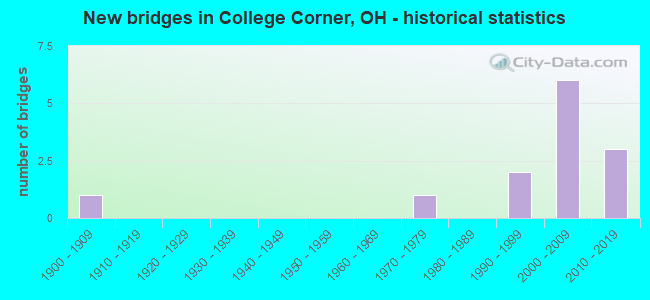
- New bridges - historical statistics
- 11900-1909
- 11970-1979
- 21990-1999
- 62000-2009
- 32010-2019

- Bridge Condition - Deck
- 33.3%Excellent
- 16.7%Very good
- 33.3%Good
- 8.3%Satisfactory
- 8.3%Poor

- Bridge Condition - Superstructure
- 33.3%Excellent
- 16.7%Very good
- 25.0%Good
- 8.3%Satisfactory
- 16.7%Poor

- Bridge Condition - Substructure
- 33.3%Excellent
- 41.7%Very good
- 8.3%Good
- 8.3%Satisfactory
- 8.3%Poor

- Bridge Condition - Channel
- 23.1%Excellent
- 15.4%Very good
- 23.1%Good
- 30.8%Satisfactory
- 7.7%Fair
Find on map >> Show street view
Structure Number: 936138, Location: 0.2 MI. NORTH OF SHERA RD (Lat: 39.539169, Lng: -84.808411), Route carried "on" structure: County highway T0050, Year Built: 2003, Status: Open, Structure Length: 1.59m (5.22ft), Average Daily Traffic: 1,178 (year 2018), Truck Traffic: 8%, Average Future Daily Traffic: 1,635 (year 2038), Design Load: HS 20, Features Intersected: STREAM, Facility Carried by Structure: STOUT ROAD
Minimum Vertical Clearance: 30+ m (98+ ft), Kilometerpoint: 0.177, Lanes on structure: 2, Owner: County Highway Agency, Approaching Roadway Width: 3.7m (12.1ft), Skew: 3 degrees, Material/Design: Prestressed concrete, Design/Construction: Box Beam or Girders - Multiple, Number Of Spans In Main Unit: 1, Length of Maximum Span: 15.5m (50.9ft), Curb-To-Curb Width: 7.3m (24.0ft), Out-to-Out Width: 7.3m (24.0ft)
Condition: Deck: Good, Superstructure: Good, Substructure: Very good, Channel: Very good, Operating Rating: 51.8 metric tons, Method Used To Determine Operating Rating: Load Factor (LF) rating reported by rating factor (RF) method using MS18 loading, Inventory Rating: 32.4 metric tons, Method Used To Determine Inventory Rating: Load Factor (LF) rating reported by rating factor (RF) method using MS18 loading, Structural Evaluation: Better than present minimum criteria, Deck Geometry: Meets minimum limits, Waterway Adequacy: Superior to present desirable criteria, Approach Roadway Alignment: Equal to present minimum criteria, Designated Inspection Frequency: Every 24 months, Inspection Date: May 2021, Deck Structure Type: Concrete Cast-file-Place, Wearing Surface/Protective System: Wearing Surface: Bituminous, Membrane: Preformed Fabric
Find on map >> Show street view
Structure Number: 6804063, Location: 1.87 MI EAST OF IND LINE (Lat: 39.626261, Lng: -84.781881), Route carried "on" structure: State highway 725, Year Built: 1993, Status: Open, Structure Length: 3.81m (12.50ft), Average Daily Traffic: 819 (year 2015), Truck Traffic: 21%, Average Future Daily Traffic: 1,137 (year 2035), Design Load: HS 20+Mod, Features Intersected: FOUR MILE CREEK
Minimum Vertical Clearance: 30+ m (98+ ft), Kilometerpoint: 3.009, Lanes on structure: 2, Owner: State Highway Agency, Approaching Roadway Width: 9.1m (29.9ft), Material/Design: Concrete continuous, Design/Construction: Slab, Number Of Spans In Main Unit: 3, Length of Maximum Span: 14.6m (47.9ft), Curb-To-Curb Width: 9.1m (29.9ft), Out-to-Out Width: 10.1m (33.1ft)
Condition: Deck: Satisfactory, Superstructure: Satisfactory, Substructure: Satisfactory, Channel: Satisfactory, Operating Rating: 42.1 metric tons, Method Used To Determine Operating Rating: Load Factor (LF) rating reported by rating factor (RF) method using MS18 loading, Inventory Rating: 32.4 metric tons, Method Used To Determine Inventory Rating: Load Factor (LF) rating reported by rating factor (RF) method using MS18 loading, Structural Evaluation: Equal to present minimum criteria, Deck Geometry: Equal to present minimum criteria, Waterway Adequacy: Superior to present desirable criteria, Approach Roadway Alignment: Equal to present desirable criteria, Designated Inspection Frequency: Every 12 months, Inspection Date: May 2021, Deck Structure Type: Concrete Cast-file-Place, Wearing Surface/Protective System: Wearing Surface: Monolithic Concrete, Deck Protection: Epoxy Coated Reinforcing
Find on map >> Show street view
Structure Number: 6826121, Location: HUESTON WOODS STATE PARK (Lat: 39.589489, Lng: -84.750581), Route carried "on" structure: State lands road 1SP, Year Built: 1997, Status: Open, Structure Length: 0.71m (2.33ft), Average Daily Traffic: 50 (year 2010), Average Future Daily Traffic: 69 (year 2030), Design Load: HS 20, Features Intersected: UNNAMED STREAM, Facility Carried by Structure: PARK ROAD
Minimum Vertical Clearance: 30+ m (98+ ft), Kilometerpoint: 4.023, Lanes on structure: 2, Owner: State Park, Forest, or Reservation Agency, Approaching Roadway Width: 6.1m (20.0ft), Skew: 3 degrees, Material/Design: Concrete, Design/Construction: Culvert, Number Of Spans In Main Unit: 1, Length of Maximum Span: 6.3m (20.7ft)
Condition: Channel: Good, Culverts: Good, Operating Rating: 42.1 metric tons, Method Used To Determine Operating Rating: Load Factor (LF) rating reported by rating factor (RF) method using MS18 loading, Inventory Rating: 32.4 metric tons, Method Used To Determine Inventory Rating: Load Factor (LF) rating reported by rating factor (RF) method using MS18 loading, Structural Evaluation: Better than present minimum criteria, Waterway Adequacy: Equal to present desirable criteria, Approach Roadway Alignment: Equal to present minimum criteria, Designated Inspection Frequency: Every 24 months, Inspection Date: April 2021
Find on map >> Show street view
Structure Number: 6841295, Location: 1ST E OF CH 41 (Lat: 39.611519, Lng: -84.785261), Route carried "on" structure: County highway T0235, Year Built: 1900, Status: Posted for load, Structure Length: 4.33m (14.21ft), Average Daily Traffic: 351 (year 2015), Truck Traffic: 7%, Average Future Daily Traffic: 487 (year 2038), Features Intersected: FOUR MILE CREEK, Facility Carried by Structure: JUNCTION RD
Minimum Vertical Clearance: 4.37m (14.34ft), Kilometerpoint: 2.575, Lanes on structure: 1, Owner: County Highway Agency, Approaching Roadway Width: 6.1m (20.0ft), Material/Design: Steel, Design/Construction: Truss - Thru, Number Of Spans In Main Unit: 3, Length of Maximum Span: 14.3m (46.9ft), Curb-To-Curb Width: 4.8m (15.7ft), Out-to-Out Width: 4.9m (16.1ft)
Condition: Deck: Good, Superstructure: Poor, Substructure: Poor, Channel: Fair, Operating Rating: 16.2 metric tons, Method Used To Determine Operating Rating: Load Factor (LF) rating reported by rating factor (RF) method using MS18 loading, Inventory Rating: 9.7 metric tons, Method Used To Determine Inventory Rating: Load Factor (LF) rating reported by rating factor (RF) method using MS18 loading, Structural Evaluation: High priority of corrective action, Deck Geometry: High priority of corrective action, Waterway Adequacy: Equal to present desirable criteria, Approach Roadway Alignment: High priority of corrective action, Bridge Posting: Required (Relationship of Operating Rating to Maximum Legal Load: > 39.9% below), Designated Inspection Frequency: Every 12 months, Critical Feature Inspection Frequency: Every 24 months, Inspection Date: May 2021, Critical Feature Inspection Date: May 2019, Deck Structure Type: Wood or Timber, Wearing Surface/Protective System: Wearing Surface: Bituminous
Find on map >> Show street view
Structure Number: 684131, Location: First bridge W of CR41 (Lat: 39.610500, Lng: -84.806619), Route carried "on" structure: County highway T235, Year Built: 2016, Status: Open, Structure Length: 0.79m (2.59ft), Average Daily Traffic: 45 (year 2016), Truck Traffic: 11%, Average Future Daily Traffic: 50 (year 2040), Design Load: HL 93, Features Intersected: Paxtons Branch, Facility Carried by Structure: Gray Rd
Minimum Vertical Clearance: 30+ m (98+ ft), Kilometerpoint: 1.127, Lanes on structure: 2, Owner: County Highway Agency, Approaching Roadway Width: 7.3m (24.0ft), Material/Design: Concrete, Design/Construction: Box Beam or Girders - Multiple, Number Of Spans In Main Unit: 1, Length of Maximum Span: 6.7m (22.0ft), Curb-To-Curb Width: 7.3m (24.0ft), Out-to-Out Width: 7.3m (24.0ft)
Condition: Deck: Very good, Superstructure: Very good, Substructure: Very good, Channel: Excellent, Operating Rating: 64.8 metric tons, Method Used To Determine Operating Rating: Load and Resistance Factor Rating (LRFR) rating reported by rating factor(RF) method using HL-93 loadings, Inventory Rating: 48.6 metric tons, Method Used To Determine Inventory Rating: Load and Resistance Factor Rating (LRFR) rating reported by rating factor(RF) method using HL-93 loadings, Structural Evaluation: Equal to present desirable criteria, Deck Geometry: Equal to present minimum criteria, Waterway Adequacy: Equal to present minimum criteria, Approach Roadway Alignment: Equal to present desirable criteria, Length Of Structure Improvement: 0.30m (0.98ft), Designated Inspection Frequency: Every 24 months, Inspection Date: May 2021, Deck Structure Type: Concrete Cast-file-Place, Wearing Surface/Protective System: Wearing Surface: Bituminous, Membrane: Preformed Fabric, Deck Protection: Other
Find on map >> Show street view
Structure Number: 6841511, Location: 1ST N OF KINGREY RD (Lat: 39.583031, Lng: -84.797819), Route carried "on" structure: County highway C0024, Year Built: 1970, Status: Open, Structure Length: 2.16m (7.09ft), Average Daily Traffic: 510 (year 2015), Truck Traffic: 7%, Average Future Daily Traffic: 708 (year 2037), Design Load: HS 20, Features Intersected: LITTLE FOUR MILE, Facility Carried by Structure: CAMDEN COLL CORNER
Minimum Vertical Clearance: 30+ m (98+ ft), Kilometerpoint: 1.931, Lanes on structure: 2, Owner: County Highway Agency, Approaching Roadway Width: 7.3m (24.0ft), Material/Design: Prestressed concrete, Design/Construction: Box Beam or Girders - Multiple, Number Of Spans In Main Unit: 1, Length of Maximum Span: 19.8m (65.0ft), Curb-To-Curb Width: 6.7m (22.0ft), Out-to-Out Width: 6.8m (22.3ft)
Condition: Deck: Poor, Superstructure: Poor, Substructure: Good, Channel: Good, Operating Rating: 97.2 metric tons, Method Used To Determine Operating Rating: Load Factor (LF) rating reported by rating factor (RF) method using MS18 loading, Inventory Rating: 61.6 metric tons, Method Used To Determine Inventory Rating: Load Factor (LF) rating reported by rating factor (RF) method using MS18 loading, Structural Evaluation: Meets minimum limits, Deck Geometry: Meets minimum limits, Waterway Adequacy: Meets minimum limits, Approach Roadway Alignment: Equal to present desirable criteria, Designated Inspection Frequency: Every 12 months, Inspection Date: May 2021, Deck Structure Type: Concrete Cast-file-Place, Wearing Surface/Protective System: Wearing Surface: Bituminous
Find on map >> Show street view
Structure Number: 6841643, Location: AT CAMP AMERICA (Lat: 39.590800, Lng: -84.781550), Route carried "on" structure: County highway T0024, Year Built: 2002, Status: Open, Structure Length: 1.43m (4.69ft), Average Daily Traffic: 510 (year 2015), Truck Traffic: 7%, Average Future Daily Traffic: 708 (year 2037), Design Load: HS 20, Features Intersected: PAXTON BRANCH, Facility Carried by Structure: CAMDEN COL CORNER
Minimum Vertical Clearance: 30+ m (98+ ft), Kilometerpoint: 4.120, Lanes on structure: 2, Owner: County Highway Agency, Approaching Roadway Width: 8.5m (27.9ft), Material/Design: Prestressed concrete, Design/Construction: Box Beam or Girders - Multiple, Number Of Spans In Main Unit: 1, Length of Maximum Span: 13.1m (43.0ft), Curb-To-Curb Width: 8.5m (27.9ft), Out-to-Out Width: 8.5m (27.9ft)
Condition: Deck: Excellent, Superstructure: Excellent, Substructure: Very good, Channel: Excellent, Operating Rating: 48.6 metric tons, Method Used To Determine Operating Rating: Load Factor (LF) rating reported by rating factor (RF) method using MS18 loading, Inventory Rating: 29.2 metric tons, Method Used To Determine Inventory Rating: Load Factor (LF) rating reported by rating factor (RF) method using MS18 loading, Structural Evaluation: Better than present minimum criteria, Deck Geometry: Somewhat better than minimum adequacy, Waterway Adequacy: Equal to present desirable criteria, Approach Roadway Alignment: Equal to present desirable criteria, Designated Inspection Frequency: Every 24 months, Inspection Date: May 2021, Deck Structure Type: Concrete Cast-file-Place, Wearing Surface/Protective System: Wearing Surface: Integral Concrete, Membrane: Preformed Fabric, Deck Protection: Epoxy Coated Reinforcing
Find on map >> Show street view
Structure Number: 6841686, Location: 1 MI. E. OF CH 41 (Lat: 39.591481, Lng: -84.780839), Route carried "on" structure: County highway C0024, Year Built: 2003, Status: Open, Structure Length: 1.16m (3.81ft), Average Daily Traffic: 510 (year 2015), Truck Traffic: 7%, Average Future Daily Traffic: 708 (year 2037), Design Load: HS 20+Mod, Features Intersected: STREAM, Facility Carried by Structure: CAMDEN COLL CORNER
Minimum Vertical Clearance: 30+ m (98+ ft), Kilometerpoint: 4.265, Lanes on structure: 2, Owner: County Highway Agency, Approaching Roadway Width: 8.5m (27.9ft), Material/Design: Prestressed concrete, Design/Construction: Box Beam or Girders - Multiple, Number Of Spans In Main Unit: 1, Length of Maximum Span: 10.7m (35.1ft), Curb-To-Curb Width: 8.5m (27.9ft), Out-to-Out Width: 8.5m (27.9ft)
Condition: Deck: Good, Superstructure: Good, Substructure: Excellent, Channel: Very good, Operating Rating: 42.1 metric tons, Method Used To Determine Operating Rating: Load Factor (LF) rating reported by rating factor (RF) method using MS18 loading, Inventory Rating: 32.4 metric tons, Method Used To Determine Inventory Rating: Load Factor (LF) rating reported by rating factor (RF) method using MS18 loading, Structural Evaluation: Better than present minimum criteria, Deck Geometry: Somewhat better than minimum adequacy, Waterway Adequacy: Superior to present desirable criteria, Approach Roadway Alignment: Equal to present minimum criteria, Designated Inspection Frequency: Every 24 months, Inspection Date: May 2021, Deck Structure Type: Concrete Cast-file-Place, Wearing Surface/Protective System: Wearing Surface: Bituminous, Membrane: Preformed Fabric, Deck Protection: Epoxy Coated Reinforcing
Find on map >> Show street view
Structure Number: 6841694, Location: .05 MI. E. OF CH 41 (Lat: 39.596839, Lng: -84.795781), Route carried "on" structure: County highway T0234, Year Built: 2003, Status: Open, Structure Length: 1.74m (5.71ft), Average Daily Traffic: 351 (year 2015), Truck Traffic: 7%, Average Future Daily Traffic: 487 (year 2037), Design Load: HS 20, Features Intersected: PAXTONS BRANCH, Facility Carried by Structure: BUCK PAXTON RD
Minimum Vertical Clearance: 30+ m (98+ ft), Kilometerpoint: 1.642, Lanes on structure: 2, Owner: County Highway Agency, Approaching Roadway Width: 7.3m (24.0ft), Material/Design: Prestressed concrete, Design/Construction: Box Beam or Girders - Multiple, Number Of Spans In Main Unit: 1, Length of Maximum Span: 16.2m (53.1ft), Curb-To-Curb Width: 7.3m (24.0ft), Out-to-Out Width: 7.3m (24.0ft)
Condition: Deck: Excellent, Superstructure: Excellent, Substructure: Excellent, Channel: Satisfactory, Operating Rating: 68.0 metric tons, Method Used To Determine Operating Rating: Load Factor (LF) rating reported by rating factor (RF) method using MS18 loading, Inventory Rating: 42.1 metric tons, Method Used To Determine Inventory Rating: Load Factor (LF) rating reported by rating factor (RF) method using MS18 loading, Structural Evaluation: Superior to present desirable criteria, Deck Geometry: Somewhat better than minimum adequacy, Waterway Adequacy: Superior to present desirable criteria, Approach Roadway Alignment: Equal to present desirable criteria, Designated Inspection Frequency: Every 24 months, Inspection Date: May 2021, Deck Structure Type: Concrete Cast-file-Place, Wearing Surface/Protective System: Wearing Surface: Bituminous, Membrane: Preformed Fabric, Deck Protection: Epoxy Coated Reinforcing
Find on map >> Show street view
Structure Number: 6841708, Location: JUST E. OF TRUSS BRIDGE (Lat: 39.611611, Lng: -84.783361), Route carried "on" structure: County highway T0235, Year Built: 2003, Status: Open, Structure Length: 1.01m (3.31ft), Average Daily Traffic: 351 (year 2015), Truck Traffic: 7%, Average Future Daily Traffic: 487 (year 2037), Design Load: HS 20+Mod, Features Intersected: STREAM, Facility Carried by Structure: JUNCTION RD.
Minimum Vertical Clearance: 30+ m (98+ ft), Kilometerpoint: 2.736, Lanes on structure: 2, Owner: County Highway Agency, Approaching Roadway Width: 7.3m (24.0ft), Skew: 3 degrees, Material/Design: Prestressed concrete, Design/Construction: Box Beam or Girders - Multiple, Number Of Spans In Main Unit: 1, Length of Maximum Span: 9.1m (29.9ft), Curb-To-Curb Width: 7.3m (24.0ft), Out-to-Out Width: 7.3m (24.0ft)
Condition: Deck: Excellent, Superstructure: Excellent, Substructure: Excellent, Channel: Good, Operating Rating: 64.8 metric tons, Method Used To Determine Operating Rating: Load Factor (LF) rating reported by rating factor (RF) method using MS18 loading, Inventory Rating: 38.9 metric tons, Method Used To Determine Inventory Rating: Load Factor (LF) rating reported by rating factor (RF) method using MS18 loading, Structural Evaluation: Superior to present desirable criteria, Deck Geometry: Somewhat better than minimum adequacy, Waterway Adequacy: Better than present minimum criteria, Approach Roadway Alignment: Equal to present desirable criteria, Designated Inspection Frequency: Every 24 months, Inspection Date: May 2021, Deck Structure Type: Concrete Cast-file-Place, Wearing Surface/Protective System: Wearing Surface: Bituminous, Membrane: Preformed Fabric, Deck Protection: Epoxy Coated Reinforcing
Find on map >> Show street view
Structure Number: 6841716, Location: .30MI N. OF BUCK PAXTON (Lat: 39.601169, Lng: -84.797169), Route carried "on" structure: County highway C0041, Year Built: 2006, Status: Open, Structure Length: 1.25m (4.10ft), Average Daily Traffic: 298 (year 2015), Truck Traffic: 7%, Average Future Daily Traffic: 414 (year 2037), Design Load: HS 20+Mod, Features Intersected: PAXTON BRANCH, Facility Carried by Structure: FAIRHAVEN COLL COR
Minimum Vertical Clearance: 30+ m (98+ ft), Kilometerpoint: 1.287, Lanes on structure: 2, Owner: County Highway Agency, Approaching Roadway Width: 7.9m (25.9ft), Material/Design: Concrete, Design/Construction: Box Beam or Girders - Multiple, Number Of Spans In Main Unit: 1, Length of Maximum Span: 11.3m (37.1ft), Curb-To-Curb Width: 7.9m (25.9ft), Out-to-Out Width: 7.9m (25.9ft)
Condition: Deck: Good, Superstructure: Good, Substructure: Very good, Channel: Satisfactory, Operating Rating: 42.1 metric tons, Method Used To Determine Operating Rating: Load Factor (LF) rating reported by rating factor (RF) method using MS18 loading, Inventory Rating: 32.4 metric tons, Method Used To Determine Inventory Rating: Load Factor (LF) rating reported by rating factor (RF) method using MS18 loading, Structural Evaluation: Better than present minimum criteria, Deck Geometry: Somewhat better than minimum adequacy, Waterway Adequacy: Equal to present desirable criteria, Approach Roadway Alignment: Equal to present minimum criteria, Designated Inspection Frequency: Every 24 months, Inspection Date: May 2021, Deck Structure Type: Concrete Cast-file-Place, Wearing Surface/Protective System: Wearing Surface: Bituminous, Membrane: Preformed Fabric, Deck Protection: Other
Find on map >> Show street view
Structure Number: 684174, Location: JUST EAST OF BUCK PAXTON (Lat: 39.591939, Lng: -84.770281), Route carried "on" structure: County highway C0024, Year Built: 2012, Status: Open, Structure Length: 3.41m (11.19ft), Average Daily Traffic: 399 (year 2015), Truck Traffic: 8%, Average Future Daily Traffic: 554 (year 2037), Design Load: HL 93, Features Intersected: FOUR MILE CREEK, Facility Carried by Structure: CAMDEN-COLL. COR.
Minimum Vertical Clearance: 4.40m (14.44ft), Kilometerpoint: 5.150, Lanes on structure: 2, Owner: County Highway Agency, Approaching Roadway Width: 8.5m (27.9ft), Material/Design: Wood or Timber, Design/Construction: Truss - Thru, Number Of Spans In Main Unit: 1, Length of Maximum Span: 32.9m (107.9ft), Curb or Sidewalk Widths: Left: 18.3m (60.0ft), Right: 18.3m (60.0ft), Curb-To-Curb Width: 8.5m (27.9ft), Out-to-Out Width: 8.5m (27.9ft)
Condition: Deck: Excellent, Superstructure: Excellent, Substructure: Excellent, Channel: Satisfactory, Operating Rating: 51.8 metric tons, Method Used To Determine Operating Rating: Load and Resistance Factor Rating (LRFR) rating reported by rating factor(RF) method using HL-93 loadings, Inventory Rating: 38.9 metric tons, Method Used To Determine Inventory Rating: Load and Resistance Factor Rating (LRFR) rating reported by rating factor(RF) method using HL-93 loadings, Structural Evaluation: Superior to present desirable criteria, Deck Geometry: Somewhat better than minimum adequacy, Waterway Adequacy: Superior to present desirable criteria, Approach Roadway Alignment: Equal to present desirable criteria, Designated Inspection Frequency: Every 24 months, Inspection Date: May 2021, Deck Structure Type: Wood or Timber, Wearing Surface/Protective System: Wearing Surface: Epoxy Overlay
Find on map >> Show street view
Structure Number: 6841759, Location: 0.18 MI W OF CH24 (Lat: 39.604350, Lng: -84.762739), Route carried "on" structure: County highway T0259, Year Built: 2011, Status: Open, Structure Length: 2.38m (7.81ft), Average Daily Traffic: 351 (year 2015), Truck Traffic: 7%, Average Future Daily Traffic: 487 (year 2037), Design Load: HL 93, Features Intersected: HOPEWELL CREEK, Facility Carried by Structure: JUNCTION RD.
Minimum Vertical Clearance: 30+ m (98+ ft), Kilometerpoint: 1.851, Lanes on structure: 2, Owner: County Highway Agency, Approaching Roadway Width: 7.3m (24.0ft), Material/Design: Prestressed concrete, Design/Construction: Box Beam or Girders - Multiple, Number Of Spans In Main Unit: 1, Length of Maximum Span: 22.9m (75.1ft), Curb-To-Curb Width: 7.3m (24.0ft), Out-to-Out Width: 7.3m (24.0ft)
Condition: Deck: Very good, Superstructure: Very good, Substructure: Very good, Channel: Excellent, Operating Rating: 51.8 metric tons, Method Used To Determine Operating Rating: Load and Resistance Factor Rating (LRFR) rating reported by rating factor(RF) method using HL-93 loadings, Inventory Rating: 42.1 metric tons, Method Used To Determine Inventory Rating: Load and Resistance Factor Rating (LRFR) rating reported by rating factor(RF) method using HL-93 loadings, Structural Evaluation: Equal to present desirable criteria, Deck Geometry: Somewhat better than minimum adequacy, Waterway Adequacy: Equal to present desirable criteria, Approach Roadway Alignment: High priority of corrective action, Designated Inspection Frequency: Every 24 months, Inspection Date: May 2021, Deck Structure Type: Concrete Cast-file-Place, Wearing Surface/Protective System: Wearing Surface: Bituminous, Membrane: Preformed Fabric, Deck Protection: Epoxy Coated Reinforcing