Bridge Statistics for Collegeville, Indiana (IN)
Condition, Traffic, Stress, Structural Evaluation, Project Costs
- National Bridge Inventory (NBI) Statistics
- 20Number of bridges
- 154ft / 46.9mTotal length
- $600,000Total costs
- 175,650Total average daily traffic
- 14,343Total average daily truck traffic
- National Bridge Inventory (NBI) Registered Bridges for Collegeville
- No street view available for this location
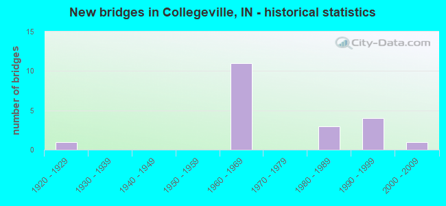
- New bridges - historical statistics
- 11920-1929
- 111960-1969
- 31980-1989
- 41990-1999
- 12000-2009

- Reconstructed bridges - Historical Statistics
- 11980-1989
- 41990-1999


- Bridge Condition - Deck
- 7.1%Excellent
- 7.1%Very good
- 21.4%Good
- 35.7%Satisfactory
- 21.4%Fair
- 7.1%Poor

- Bridge Condition - Superstructure
- 7.1%Excellent
- 7.1%Very good
- 35.7%Good
- 28.6%Satisfactory
- 14.3%Fair
- 7.1%Poor

- Bridge Condition - Substructure
- 14.3%Very good
- 42.9%Good
- 21.4%Satisfactory
- 21.4%Fair

- Bridge Condition - Channel
- 8.3%Very good
- 50.0%Good
- 25.0%Satisfactory
- 16.7%Fair
Find on map >> Show street view
Structure Number: 2482, Location: 01.55 S SR 236 (Lat: 39.837861, Lng: -86.647239), Route carried "on" structure: State highway 75, Year Built: 1985, Status: Open, Structure Length: 3.02m (9.91ft), Average Daily Traffic: 948 (year 2004), Truck Traffic: 10%, Average Future Daily Traffic: 1,574 (year 2030), Design Load: HS 20, Features Intersected: BRANCH BIG WALNUT CREEK
Minimum Vertical Clearance: 30+ m (98+ ft), Kilometerpoint: 24.639, Lanes on structure: 2, Owner: State Highway Agency, Approaching Roadway Width: 10.4m (34.1ft), Skew: 2 degrees, Material/Design: Concrete continuous, Design/Construction: Slab, Number Of Spans In Main Unit: 3, Length of Maximum Span: 11.1m (36.4ft), Curb-To-Curb Width: 10.4m (34.1ft), Out-to-Out Width: 11.1m (36.4ft)
Condition: Deck: Good, Superstructure: Good, Substructure: Fair, Channel: Very good, Operating Rating: 32.4 metric tons, Method Used To Determine Operating Rating: Load and Resistance Factor Rating (LRFR) rating reported by rating factor(RF) method using HL-93 loadings, Inventory Rating: 24.9 metric tons, Method Used To Determine Inventory Rating: Load and Resistance Factor Rating (LRFR) rating reported by rating factor(RF) method using HL-93 loadings, Structural Evaluation: Somewhat better than minimum adequacy, Deck Geometry: Equal to present minimum criteria, Waterway Adequacy: Equal to present desirable criteria, Approach Roadway Alignment: Equal to present desirable criteria, Designated Inspection Frequency: Every 24 months, Inspection Date: December 2021, Deck Structure Type: Concrete Cast-file-Place, Wearing Surface/Protective System: Wearing Surface: Epoxy Overlay, Deck Protection: Epoxy Coated Reinforcing
Find on map >> Show street view
Structure Number: 2599, Location: 03.62 S SR 44 (Lat: 39.591450, Lng: -85.162150), Route carried "on" structure: State highway 121, Year Built: 1968, Year Reconstructed: 2021, Status: Open, Structure Length: 2.78m (9.12ft), Average Daily Traffic: 3,110 (year 2020), Truck Traffic: 20%, Average Future Daily Traffic: 3,110 (year 2040), Design Load: HL 93, Features Intersected: FALL CREEK
Minimum Vertical Clearance: 30+ m (98+ ft), Kilometerpoint: 8.336, Lanes on structure: 2, Owner: State Highway Agency, Approaching Roadway Width: 6.1m (20.0ft), Material/Design: Prestressed concrete continuous, Design/Construction: Box Beam or Girders - Single/Spread, Number Of Spans In Main Unit: 3, Length of Maximum Span: 15.3m (50.2ft), Curb-To-Curb Width: 11.1m (36.4ft), Out-to-Out Width: 11.7m (38.4ft)
Condition: Deck: Excellent, Superstructure: Excellent, Substructure: Good, Channel: Satisfactory, Operating Rating: 64.2 metric tons, Method Used To Determine Operating Rating: Load and Resistance Factor Rating (LRFR) rating reported by rating factor(RF) method using HL-93 loadings, Inventory Rating: 48.6 metric tons, Method Used To Determine Inventory Rating: Load and Resistance Factor Rating (LRFR) rating reported by rating factor(RF) method using HL-93 loadings, Structural Evaluation: Better than present minimum criteria, Deck Geometry: Somewhat better than minimum adequacy, Waterway Adequacy: Equal to present desirable criteria, Approach Roadway Alignment: Equal to present minimum criteria, Designated Inspection Frequency: Every 24 months, Inspection Date: January 2021, Deck Structure Type: Concrete Cast-file-Place, Wearing Surface/Protective System: Wearing Surface: Monolithic Concrete, Deck Protection: Epoxy Coated Reinforcing
Find on map >> Show street view
Structure Number: 2946, Location: 01.71 N SR 16 (Lat: 40.891511, Lng: -87.154756), Route carried "on" structure: US 231, Year Built: 1929, Year Reconstructed: 1997, Status: Open, Structure Length: 2.29m (7.51ft), Average Daily Traffic: 5,528 (year 2004), Truck Traffic: 10%, Average Future Daily Traffic: 9,178 (year 2030), Design Load: H 20, Features Intersected: HOWE DITCH
Minimum Vertical Clearance: 30+ m (98+ ft), Kilometerpoint: 18.540, Lanes on structure: 2, Owner: State Highway Agency, Approaching Roadway Width: 11.9m (39.0ft), Material/Design: Steel, Design/Construction: Stringer/Multi-beam, Number Of Spans In Main Unit: 1, Length of Maximum Span: 21.9m (71.9ft), Curb-To-Curb Width: 11.9m (39.0ft), Out-to-Out Width: 12.8m (42.0ft)
Condition: Deck: Satisfactory, Superstructure: Good, Substructure: Fair, Channel: Fair, Operating Rating: 42.4 metric tons, Method Used To Determine Operating Rating: Load and Resistance Factor Rating (LRFR) rating reported by rating factor(RF) method using HL-93 loadings, Inventory Rating: 32.7 metric tons, Method Used To Determine Inventory Rating: Load and Resistance Factor Rating (LRFR) rating reported by rating factor(RF) method using HL-93 loadings, Structural Evaluation: Somewhat better than minimum adequacy, Deck Geometry: Somewhat better than minimum adequacy, Waterway Adequacy: Equal to present minimum criteria, Approach Roadway Alignment: Equal to present desirable criteria, Designated Inspection Frequency: Every 24 months, Inspection Date: April 2021, Deck Structure Type: Concrete Cast-file-Place, Wearing Surface/Protective System: Wearing Surface: Monolithic Concrete, Deck Protection: Epoxy Coated Reinforcing
Find on map >> Show street view
Structure Number: 3804, Location: 02.16 N US 231 (Lat: 40.837181, Lng: -87.172450), Route carried "on" structure: Alternate County highway , Year Built: 1968, Year Reconstructed: 1991, Status: Open, Structure Length: 5.91m (19.39ft), Average Daily Traffic: 167 (year 2004), Truck Traffic: 10%, Average Future Daily Traffic: 277 (year 2030), Design Load: HS 20, Features Intersected: I-65 SB/NB, Facility Carried by Structure: CR 1200 S/RANGE LN
Minimum Vertical Clearance: 30+ m (98+ ft), Kilometerpoint: 0.000, Lanes on structure: 2, Lanes under structure: 4, Owner: State Highway Agency, Approaching Roadway Width: 9.1m (29.9ft), Skew: 2 degrees, Material/Design: Steel continuous, Design/Construction: Stringer/Multi-beam, Number Of Spans In Main Unit: 2, Length of Maximum Span: 29.3m (96.1ft), Curb-To-Curb Width: 8.1m (26.6ft), Out-to-Out Width: 9.0m (29.5ft)
Condition: Deck: Fair, Superstructure: Satisfactory, Substructure: Good, Operating Rating: 41.5 metric tons, Method Used To Determine Operating Rating: Load and Resistance Factor Rating (LRFR) rating reported by rating factor(RF) method using HL-93 loadings, Inventory Rating: 32.1 metric tons, Method Used To Determine Inventory Rating: Load and Resistance Factor Rating (LRFR) rating reported by rating factor(RF) method using HL-93 loadings, Structural Evaluation: Equal to present minimum criteria, Deck Geometry: Somewhat better than minimum adequacy, Underclear: Meets minimum limits, Approach Roadway Alignment: Equal to present desirable criteria, Designated Inspection Frequency: Every 24 months, Other Special Inspection Frequency: Every 48 months, Inspection Date: May 2021, Other Special Inspection Date: April 2021, Deck Structure Type: Concrete Cast-file-Place, Wearing Surface/Protective System: Wearing Surface: Latex Concrete, Deck Protection: Epoxy Coated Reinforcing
Find on map >> Show street view
Structure Number: 3805, Location: 00.86 N SR 16 (Lat: 40.877700, Lng: -87.195375), Route carried "on" structure: Interstate 65, Year Built: 1966, Year Reconstructed: 1996, Status: Open, Structure Length: 3.29m (10.79ft), Average Daily Traffic: 12,481 (year 2004), Truck Traffic: 10%, Average Future Daily Traffic: 22,602 (year 2028), Design Load: HS 20+Mod, Features Intersected: CARPENTER CREEK
Minimum Vertical Clearance: 30+ m (98+ ft), Kilometerpoint: 337.479, Lanes on structure: 2, Base Highway Network: Yes (, Subroute: 1), Owner: State Highway Agency, Approaching Roadway Width: 11.6m (38.1ft), Material/Design: Concrete continuous, Design/Construction: Slab, Number Of Spans In Main Unit: 3, Length of Maximum Span: 13.0m (42.7ft), Curb-To-Curb Width: 12.2m (40.0ft), Out-to-Out Width: 13.0m (42.7ft)
Condition: Deck: Satisfactory, Superstructure: Satisfactory, Substructure: Good, Channel: Good, Operating Rating: 45.0 metric tons, Method Used To Determine Operating Rating: Load and Resistance Factor Rating (LRFR) rating reported by rating factor(RF) method using HL-93 loadings, Inventory Rating: 34.7 metric tons, Method Used To Determine Inventory Rating: Load and Resistance Factor Rating (LRFR) rating reported by rating factor(RF) method using HL-93 loadings, Structural Evaluation: Equal to present minimum criteria, Deck Geometry: Better than present minimum criteria, Waterway Adequacy: Equal to present desirable criteria, Approach Roadway Alignment: Equal to present desirable criteria, Designated Inspection Frequency: Every 24 months, Inspection Date: May 2021, Deck Structure Type: Concrete Cast-file-Place, Wearing Surface/Protective System: Wearing Surface: Latex Concrete
Find on map >> Show street view
Structure Number: 3806, Location: 00.86 N SR 16 (Lat: 40.877500, Lng: -87.196031), Route carried "on" structure: Interstate 65, Year Built: 1966, Year Reconstructed: 1997, Status: Open, Structure Length: 3.29m (10.79ft), Average Daily Traffic: 12,481 (year 2004), Truck Traffic: 10%, Average Future Daily Traffic: 22,602 (year 2030), Design Load: HL 93, Features Intersected: CARPENTER CREEK
Minimum Vertical Clearance: 30+ m (98+ ft), Kilometerpoint: 337.479, Lanes on structure: 2, Base Highway Network: Yes (, Subroute: 1), Owner: State Highway Agency, Approaching Roadway Width: 11.6m (38.1ft), Material/Design: Concrete continuous, Design/Construction: Slab, Number Of Spans In Main Unit: 3, Length of Maximum Span: 13.0m (42.7ft), Curb-To-Curb Width: 12.2m (40.0ft), Out-to-Out Width: 13.0m (42.7ft)
Condition: Deck: Poor, Superstructure: Poor, Substructure: Good, Channel: Satisfactory, Operating Rating: 35.0 metric tons, Method Used To Determine Operating Rating: Load and Resistance Factor Rating (LRFR) rating reported by rating factor(RF) method using HL-93 loadings, Inventory Rating: 26.9 metric tons, Method Used To Determine Inventory Rating: Load and Resistance Factor Rating (LRFR) rating reported by rating factor(RF) method using HL-93 loadings, Structural Evaluation: Meets minimum limits, Deck Geometry: Better than present minimum criteria, Waterway Adequacy: Better than present minimum criteria, Approach Roadway Alignment: Equal to present desirable criteria, Designated Inspection Frequency: Every 12 months, Inspection Date: October 2021, Deck Structure Type: Concrete Cast-file-Place, Wearing Surface/Protective System: Wearing Surface: Latex Concrete, Deck Protection: Epoxy Coated Reinforcing
Find on map >> Show street view
Structure Number: 3807, Location: 01.62 N SR 16 (Lat: 40.887939, Lng: -87.200753), Route carried "on" structure: Alternate County highway 65, Year Built: 1966, Year Reconstructed: 1996, Status: Open, Structure Length: 6.80m (22.31ft), Average Daily Traffic: 183 (year 2004), Truck Traffic: 10%, Average Future Daily Traffic: 303 (year 2028), Design Load: HS 20, Features Intersected: I-65 SB/NB, Facility Carried by Structure: CR 850 S/LAIRD HIL
Minimum Vertical Clearance: 30+ m (98+ ft), Kilometerpoint: 0.000, Lanes on structure: 2, Lanes under structure: 4, Owner: State Highway Agency, Approaching Roadway Width: 9.8m (32.2ft), Skew: 2 degrees, Material/Design: Steel continuous, Design/Construction: Stringer/Multi-beam, Number Of Spans In Main Unit: 4, Length of Maximum Span: 21.9m (71.9ft), Curb-To-Curb Width: 8.2m (26.9ft), Out-to-Out Width: 9.0m (29.5ft)
Condition: Deck: Satisfactory, Superstructure: Good, Substructure: Good, Operating Rating: 44.4 metric tons, Method Used To Determine Operating Rating: Load Factor (LF), Inventory Rating: 26.6 metric tons, Method Used To Determine Inventory Rating: Load Factor (LF), Structural Evaluation: Equal to present minimum criteria, Deck Geometry: Somewhat better than minimum adequacy, Underclear: Meets minimum limits, Approach Roadway Alignment: Equal to present desirable criteria, Designated Inspection Frequency: Every 24 months, Other Special Inspection Frequency: Every 50 months, Inspection Date: May 2021, Other Special Inspection Date: June 2019, Deck Structure Type: Concrete Cast-file-Place, Wearing Surface/Protective System: Wearing Surface: Latex Concrete
Find on map >> Show street view
Structure Number: 3700006, Location: 00.25 S OF CR 800 S (Lat: 40.892139, Lng: -87.138619), Route carried "on" structure: County highway 354, Year Built: 1987, Status: Open, Structure Length: 2.71m (8.89ft), Average Daily Traffic: 163 (year 2012), Truck Traffic: 5%, Average Future Daily Traffic: 233 (year 2032), Features Intersected: HOWE DITCH, Facility Carried by Structure: CR 480 WEST
Minimum Vertical Clearance: 30+ m (98+ ft), Kilometerpoint: 0.000, Lanes on structure: 2, Owner: County Highway Agency, Approaching Roadway Width: 4.9m (16.1ft), Skew: 1 degrees, Material/Design: Concrete continuous, Design/Construction: Slab, Number Of Spans In Main Unit: 3, Length of Maximum Span: 11.9m (39.0ft), Curb-To-Curb Width: 7.3m (24.0ft), Out-to-Out Width: 8.1m (26.6ft)
Condition: Deck: Good, Superstructure: Good, Substructure: Satisfactory, Channel: Satisfactory, Operating Rating: 39.4 metric tons, Method Used To Determine Operating Rating: Field evaluation and documented engineering judgment, Inventory Rating: 32.7 metric tons, Method Used To Determine Inventory Rating: Field evaluation and documented engineering judgment, Structural Evaluation: Equal to present minimum criteria, Deck Geometry: Somewhat better than minimum adequacy, Waterway Adequacy: Better than present minimum criteria, Approach Roadway Alignment: Equal to present desirable criteria, Designated Inspection Frequency: Every 24 months, Inspection Date: August 2020, Deck Structure Type: Concrete Cast-file-Place, Wearing Surface/Protective System: Wearing Surface: Monolithic Concrete
Find on map >> Show street view
Structure Number: 3700019, Location: 00.00 S OF CR 1100 S (Lat: 40.851831, Lng: -87.119139), Route carried "on" structure: County highway 359, Year Built: 1997, Status: Open, Structure Length: 2.80m (9.19ft), Average Daily Traffic: 128 (year 2012), Truck Traffic: 5%, Average Future Daily Traffic: 183 (year 2032), Features Intersected: BICE DITCH, Facility Carried by Structure: CR 380 WEST
Minimum Vertical Clearance: 30+ m (98+ ft), Kilometerpoint: 0.000, Lanes on structure: 2, Owner: County Highway Agency, Approaching Roadway Width: 6.7m (22.0ft), Skew: 3 degrees, Material/Design: Concrete continuous, Design/Construction: Slab, Number Of Spans In Main Unit: 3, Length of Maximum Span: 10.5m (34.4ft), Curb-To-Curb Width: 8.5m (27.9ft), Out-to-Out Width: 8.7m (28.5ft)
Condition: Deck: Satisfactory, Superstructure: Satisfactory, Substructure: Satisfactory, Channel: Good, Operating Rating: 39.4 metric tons, Method Used To Determine Operating Rating: Field evaluation and documented engineering judgment, Inventory Rating: 32.7 metric tons, Method Used To Determine Inventory Rating: Field evaluation and documented engineering judgment, Structural Evaluation: Equal to present minimum criteria, Deck Geometry: Equal to present minimum criteria, Waterway Adequacy: Better than present minimum criteria, Approach Roadway Alignment: Equal to present desirable criteria, Designated Inspection Frequency: Every 24 months, Inspection Date: August 2020, Deck Structure Type: Concrete Cast-file-Place, Wearing Surface/Protective System: Wearing Surface: Monolithic Concrete, Deck Protection: Epoxy Coated Reinforcing
Find on map >> Show street view
Structure Number: 3700029, Location: 00.20 E OF CR 900 W (Lat: 40.857881, Lng: -87.207111), Route carried "on" structure: County highway 16, Year Built: 1990, Status: Open, Structure Length: 3.12m (10.24ft), Average Daily Traffic: 58 (year 2012), Truck Traffic: 5%, Average Future Daily Traffic: 83 (year 2032), Features Intersected: CARPENTER CREEK, Facility Carried by Structure: CR 1080 SOUTH
Minimum Vertical Clearance: 30+ m (98+ ft), Kilometerpoint: 0.000, Lanes on structure: 2, Owner: County Highway Agency, Approaching Roadway Width: 4.6m (15.1ft), Skew: 2 degrees, Material/Design: Concrete continuous, Design/Construction: Slab, Number Of Spans In Main Unit: 3, Length of Maximum Span: 12.0m (39.4ft), Curb-To-Curb Width: 7.3m (24.0ft), Out-to-Out Width: 8.1m (26.6ft)
Condition: Deck: Satisfactory, Superstructure: Satisfactory, Substructure: Good, Channel: Fair, Operating Rating: 54.5 metric tons, Method Used To Determine Operating Rating: Field evaluation and documented engineering judgment, Inventory Rating: 32.7 metric tons, Method Used To Determine Inventory Rating: Field evaluation and documented engineering judgment, Structural Evaluation: Equal to present minimum criteria, Deck Geometry: Equal to present minimum criteria, Waterway Adequacy: Somewhat better than minimum adequacy, Approach Roadway Alignment: Equal to present minimum criteria, Designated Inspection Frequency: Every 24 months, Inspection Date: August 2020, Deck Structure Type: Concrete Cast-file-Place, Wearing Surface/Protective System: Wearing Surface: Monolithic Concrete
Find on map >> Show street view
Structure Number: 3700041, Location: 00.50 S OF CR 1100 S (Lat: 40.846311, Lng: -87.138061), Route carried "on" structure: County highway 354, Year Built: 1999, Status: Open, Structure Length: 2.19m (7.19ft), Average Daily Traffic: 93 (year 2012), Truck Traffic: 5%, Average Future Daily Traffic: 133 (year 2032), Design Load: HS 20, Features Intersected: BICE DITCH, Facility Carried by Structure: CR 480 WEST
Minimum Vertical Clearance: 30+ m (98+ ft), Kilometerpoint: 0.000, Lanes on structure: 2, Owner: County Highway Agency, Approaching Roadway Width: 4.9m (16.1ft), Skew: 2 degrees, Material/Design: Concrete continuous, Design/Construction: Slab, Number Of Spans In Main Unit: 3, Length of Maximum Span: 8.2m (26.9ft), Curb-To-Curb Width: 8.6m (28.2ft), Out-to-Out Width: 8.7m (28.5ft)
Condition: Deck: Good, Superstructure: Good, Substructure: Very good, Channel: Good, Operating Rating: 64.1 metric tons, Method Used To Determine Operating Rating: Load Factor (LF), Inventory Rating: 38.4 metric tons, Method Used To Determine Inventory Rating: Load Factor (LF), Structural Evaluation: Better than present minimum criteria, Deck Geometry: Better than present minimum criteria, Waterway Adequacy: Equal to present desirable criteria, Approach Roadway Alignment: Equal to present desirable criteria, Designated Inspection Frequency: Every 24 months, Inspection Date: August 2020, Deck Structure Type: Concrete Cast-file-Place, Wearing Surface/Protective System: Wearing Surface: Monolithic Concrete, Membrane: Epoxy, Deck Protection: Epoxy Coated Reinforcing
Find on map >> Show street view
Structure Number: 3700044, Location: 00.00 S OF CR 800 S (Lat: 40.894500, Lng: -87.168681), Route carried "on" structure: County highway 165, Year Built: 1993, Status: Open, Structure Length: 2.48m (8.14ft), Average Daily Traffic: 163 (year 2012), Truck Traffic: 3%, Average Future Daily Traffic: 233 (year 2032), Design Load: HS 20, Features Intersected: HOWE DITCH, Facility Carried by Structure: CR 650 WEST
Minimum Vertical Clearance: 30+ m (98+ ft), Kilometerpoint: 0.000, Lanes on structure: 2, Owner: County Highway Agency, Approaching Roadway Width: 5.2m (17.1ft), Skew: 2 degrees, Material/Design: Concrete continuous, Design/Construction: Slab, Number Of Spans In Main Unit: 3, Length of Maximum Span: 9.8m (32.2ft), Curb-To-Curb Width: 6.9m (22.6ft), Out-to-Out Width: 7.4m (24.3ft)
Condition: Deck: Fair, Superstructure: Fair, Substructure: Satisfactory, Channel: Good, Operating Rating: 65.2 metric tons, Method Used To Determine Operating Rating: Load Factor (LF), Inventory Rating: 39.0 metric tons, Method Used To Determine Inventory Rating: Load Factor (LF), Structural Evaluation: Somewhat better than minimum adequacy, Deck Geometry: Meets minimum limits, Waterway Adequacy: Equal to present minimum criteria, Approach Roadway Alignment: Equal to present desirable criteria, Designated Inspection Frequency: Every 24 months, Inspection Date: August 2020, Deck Structure Type: Concrete Cast-file-Place, Wearing Surface/Protective System: Wearing Surface: Monolithic Concrete
Find on map >> Show street view
Structure Number: 3700045, Location: 00.20 E OF CR 800 W (Lat: 40.887961, Lng: -87.189450), Route carried "on" structure: County highway 20, Year Built: 2002, Status: Open, Structure Length: 3.22m (10.56ft), Average Daily Traffic: 98 (year 2019), Truck Traffic: 5%, Average Future Daily Traffic: 140 (year 2039), Features Intersected: CARPENTER CREEK, Facility Carried by Structure: CR 850 SOUTH
Minimum Vertical Clearance: 30+ m (98+ ft), Kilometerpoint: 0.000, Lanes on structure: 2, Owner: County Highway Agency, Approaching Roadway Width: 6.7m (22.0ft), Material/Design: Concrete continuous, Design/Construction: Slab, Number Of Spans In Main Unit: 3, Length of Maximum Span: 11.9m (39.0ft), Curb-To-Curb Width: 8.5m (27.9ft), Out-to-Out Width: 8.7m (28.5ft)
Condition: Deck: Very good, Superstructure: Very good, Substructure: Very good, Channel: Good, Operating Rating: 54.5 metric tons, Method Used To Determine Operating Rating: Field evaluation and documented engineering judgment, Inventory Rating: 32.7 metric tons, Method Used To Determine Inventory Rating: Field evaluation and documented engineering judgment, Structural Evaluation: Equal to present desirable criteria, Deck Geometry: Better than present minimum criteria, Waterway Adequacy: Better than present minimum criteria, Approach Roadway Alignment: Equal to present desirable criteria, Designated Inspection Frequency: Every 24 months, Inspection Date: August 2020, Deck Structure Type: Concrete Cast-file-Place, Wearing Surface/Protective System: Wearing Surface: Monolithic Concrete, Membrane: Epoxy, Deck Protection: Epoxy Coated Reinforcing
Find on map >> Show street view
Structure Number: 3700046, Location: 00.00 S OF CR 800 S (Lat: 40.889981, Lng: -87.192950), Route carried "on" structure: County highway 153, Year Built: 1984, Status: Open, Structure Length: 2.95m (9.68ft), Average Daily Traffic: 116 (year 2012), Truck Traffic: 5%, Average Future Daily Traffic: 166 (year 2032), Features Intersected: CARPENTER CREEK, Facility Carried by Structure: CR 780 WEST
Minimum Vertical Clearance: 30+ m (98+ ft), Kilometerpoint: 0.000, Lanes on structure: 2, Owner: County Highway Agency, Approaching Roadway Width: 4.9m (16.1ft), Skew: 2 degrees, Material/Design: Prestressed concrete, Design/Construction: Box Beam or Girders - Multiple, Number Of Spans In Main Unit: 3, Length of Maximum Span: 11.0m (36.1ft), Curb-To-Curb Width: 5.5m (18.0ft), Out-to-Out Width: 5.5m (18.0ft)
Condition: Deck: Fair, Superstructure: Fair, Substructure: Fair, Channel: Good, Operating Rating: 57.8 metric tons, Method Used To Determine Operating Rating: Load Factor (LF), Inventory Rating: 34.6 metric tons, Method Used To Determine Inventory Rating: Load Factor (LF), Structural Evaluation: Somewhat better than minimum adequacy, Deck Geometry: High priority of corrective action, Waterway Adequacy: Somewhat better than minimum adequacy, Approach Roadway Alignment: Equal to present desirable criteria, Length Of Structure Improvement: 3.35m (10.99ft), Designated Inspection Frequency: Every 24 months, Inspection Date: August 2020, Bridge Improvement Cost: $450,000, Roadway Improvement Cost: $150,000, Total Project Cost: $600,000 ( Estimate for 2020), Deck Structure Type: Concrete Precast Panels, Wearing Surface/Protective System: Wearing Surface: Bituminous
Find on map >> Show street view
Structure Number: 422, Location: 01.73 W US 231 (Lat: 40.866181, Lng: -87.188972), Route carried "under" structure: Interstate 65, Year Built: 1966, Structure Length: 0. m, Average Daily Traffic: 17,392 (year 2020), Truck Traffic: 15%, Features Intersected: SR 16
Minimum Vertical Clearance: 4.95m (16.24ft), Kilometerpoint: 336.095, Lanes on structure: 2, Lanes under structure: 4, Material/Design: Steel continuous, Design/Construction: Stringer/Multi-beam, Length of Maximum Span: 22.0m (72.2ft)
Find on map >> Show street view
Structure Number: 422, Location: 01.73 W US 231 (Lat: 40.866181, Lng: -87.188972), Route carried "under" structure: Interstate 65, Year Built: 1966, Structure Length: 0. m, Average Daily Traffic: 17,778 (year 2020), Truck Traffic: 15%, Features Intersected: SR 16
Minimum Vertical Clearance: 4.95m (16.24ft), Kilometerpoint: 336.095, Lanes on structure: 2, Lanes under structure: 4, Material/Design: Steel continuous, Design/Construction: Stringer/Multi-beam, Length of Maximum Span: 22.0m (72.2ft)
Find on map >> Show street view
Structure Number: 3804, Location: 02.16 N US-231 (Lat: 40.837181, Lng: -87.172456), Route carried "under" structure: Interstate 65, Year Built: 1968, Structure Length: 0. m, Average Daily Traffic: 24,961 (year 2004), Truck Traffic: 5%, Features Intersected: I-65 SBL, Facility Carried by Structure: CR 1200S/RANGE LN
Minimum Vertical Clearance: 4.93m (16.17ft), Kilometerpoint: 332.603, Lanes on structure: 2, Lanes under structure: 4, Material/Design: Steel continuous, Design/Construction: Stringer/Multi-beam, Length of Maximum Span: 29.3m (96.1ft)
Find on map >> Show street view
Structure Number: 3804, Location: 02.16 N US-231 (Lat: 40.837181, Lng: -87.172456), Route carried "under" structure: Interstate 65, Year Built: 1968, Structure Length: 0. m, Average Daily Traffic: 29,880 (year 2004), Truck Traffic: 5%, Features Intersected: I-65 NBL, Facility Carried by Structure: CR 1200S/RANGE LN
Minimum Vertical Clearance: 4.93m (16.17ft), Kilometerpoint: 332.603, Lanes on structure: 2, Lanes under structure: 4, Material/Design: Steel continuous, Design/Construction: Stringer/Multi-beam, Length of Maximum Span: 29.3m (96.1ft)
Find on map >> Show street view
Structure Number: 3807, Location: 01.62 N SR 16 (Lat: 40.887939, Lng: -87.200753), Route carried "under" structure: Interstate 65, Year Built: 1966, Structure Length: 0. m, Average Daily Traffic: 24,961 (year 2004), Truck Traffic: 5%, Features Intersected: I 65 NBL, Facility Carried by Structure: CR 850S/LAIRD HILL
Minimum Vertical Clearance: 4.93m (16.17ft), Kilometerpoint: 338.703, Lanes on structure: 2, Lanes under structure: 4, Material/Design: Steel continuous, Design/Construction: Stringer/Multi-beam, Length of Maximum Span: 21.9m (71.9ft)
Find on map >> Show street view
Structure Number: 3807, Location: 01.62 N SR 16 (Lat: 40.887939, Lng: -87.200753), Route carried "under" structure: Interstate 65, Year Built: 1966, Structure Length: 0. m, Average Daily Traffic: 24,961 (year 2004), Truck Traffic: 5%, Features Intersected: I-65 SBL, Facility Carried by Structure: CR 850S/LAIRD HILL
Minimum Vertical Clearance: 4.93m (16.17ft), Kilometerpoint: 338.703, Lanes on structure: 2, Lanes under structure: 4, Material/Design: Steel continuous, Design/Construction: Stringer/Multi-beam, Length of Maximum Span: 21.9m (71.9ft)