Bridge Statistics for Collinsville, Alabama (AL)
Condition, Traffic, Stress, Structural Evaluation, Project Costs
- National Bridge Inventory (NBI) Statistics
- 27Number of bridges
- 367ft / 112mTotal length
- $32,150,000Total costs
- 127,450Total average daily traffic
- 30,533Total average daily truck traffic
- National Bridge Inventory (NBI) Registered Bridges for Collinsville
- No street view available for this location
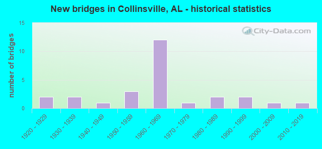
- New bridges - historical statistics
- 21920-1929
- 21930-1939
- 11940-1949
- 31950-1959
- 121960-1969
- 11970-1979
- 21980-1989
- 21990-1999
- 12000-2009
- 12010-2019


- Bridge Condition - Deck
- 5.6%Excellent
- 11.1%Very good
- 61.1%Satisfactory
- 22.2%Fair

- Bridge Condition - Superstructure
- 5.6%Excellent
- 11.1%Very good
- 72.2%Satisfactory
- 11.1%Fair

- Bridge Condition - Substructure
- 5.6%Excellent
- 5.6%Very good
- 27.8%Good
- 61.1%Satisfactory

- Bridge Condition - Channel
- 28.6%Good
- 61.9%Satisfactory
- 9.5%Fair

- Bridge Condition - Culverts
- 33.3%Good
- 33.3%Satisfactory
- 33.3%Fair
Find on map >> Show street view
Structure Number: 141, Location: 0.1 MI N OF SR 68 (Lat: 34.266200, Lng: -85.862400), Route carried "on" structure: City street , Year Built: 1920, Status: Posted for load, Structure Length: 3.05m (10.01ft), Average Daily Traffic: 50 (year 2021), Average Future Daily Traffic: 75 (year 2041), Design Load: H 10, Features Intersected: LITTLE WILLS CREEK, Facility Carried by Structure: NORTH VALLEY RD
Minimum Vertical Clearance: 30+ m (98+ ft), Kilometerpoint: 0.010, Lanes on structure: 1, Owner: City or Municipal Highway Agency, Approaching Roadway Width: 4.3m (14.1ft), Skew: 1 degrees, Material/Design: Wood or Timber, Design/Construction: Stringer/Multi-beam, Number Of Spans In Main Unit: 5, Length of Maximum Span: 6.1m (20.0ft), Curb or Sidewalk Widths: Left: 0.1m (0.3ft), Right: 0.1m (0.3ft), Curb-To-Curb Width: 2.9m (9.5ft), Out-to-Out Width: 3.3m (10.8ft)
Condition: Deck: Satisfactory, Superstructure: Satisfactory, Substructure: Satisfactory, Channel: Good, Operating Rating: 22.0 metric tons, Method Used To Determine Operating Rating: Allowable Stress (AS), Inventory Rating: 15.7 metric tons, Method Used To Determine Inventory Rating: Allowable Stress (AS), Structural Evaluation: Meets minimum limits, Deck Geometry: High priority of replacement, Waterway Adequacy: Equal to present minimum criteria, Approach Roadway Alignment: Equal to present minimum criteria, Bridge Posting: Required (Relationship of Operating Rating to Maximum Legal Load: > 39.9% below), Length Of Structure Improvement: 3.90m (12.80ft), Designated Inspection Frequency: Every 24 months, Other Special Inspection Frequency: Every 12 months, Inspection Date: April 2020, Other Special Inspection Date: April 2021, Bridge Improvement Cost: $267,000, Roadway Improvement Cost: $27,000, Total Project Cost: $294,000 ( Estimate for 2022), Deck Structure Type: Wood or Timber, Wearing Surface/Protective System: Wearing Surface: Wood or Timber
Find on map >> Show street view
Structure Number: 294, Location: BETWEEN MAIN * REED ST (Lat: 34.265700, Lng: -85.860900), Route carried "on" structure: City street , Year Built: 1925, Status: Posted for load, Structure Length: 2.44m (8.01ft), Average Daily Traffic: 61 (year 2021), Average Future Daily Traffic: 85 (year 2041), Design Load: H 10, Features Intersected: LITTLE WILLS CREEK, Facility Carried by Structure: COLLEGE AVE
Minimum Vertical Clearance: 30+ m (98+ ft), Kilometerpoint: 0.010, Lanes on structure: 2, Owner: City or Municipal Highway Agency, Approaching Roadway Width: 4.9m (16.1ft), Skew: 1 degrees, Material/Design: Wood or Timber, Design/Construction: Stringer/Multi-beam, Number Of Spans In Main Unit: 4, Length of Maximum Span: 6.1m (20.0ft), Curb or Sidewalk Widths: Left: 0.2m (0.7ft), Right: 0.2m (0.7ft), Curb-To-Curb Width: 6.1m (20.0ft), Out-to-Out Width: 6.9m (22.6ft)
Condition: Deck: Satisfactory, Superstructure: Satisfactory, Substructure: Satisfactory, Channel: Satisfactory, Operating Rating: 17.1 metric tons, Method Used To Determine Operating Rating: Allowable Stress (AS), Inventory Rating: 12.2 metric tons, Method Used To Determine Inventory Rating: Allowable Stress (AS), Structural Evaluation: Meets minimum limits, Deck Geometry: Somewhat better than minimum adequacy, Waterway Adequacy: Equal to present minimum criteria, Approach Roadway Alignment: Equal to present minimum criteria, Bridge Posting: Required (Relationship of Operating Rating to Maximum Legal Load: > 39.9% below), Length Of Structure Improvement: 3.31m (10.86ft), Designated Inspection Frequency: Every 24 months, Other Special Inspection Frequency: Every 12 months, Inspection Date: April 2020, Other Special Inspection Date: April 2021, Bridge Improvement Cost: $499,000, Roadway Improvement Cost: $50,000, Total Project Cost: $549,000 ( Estimate for 2022), Deck Structure Type: Wood or Timber, Wearing Surface/Protective System: Wearing Surface: Wood or Timber
Find on map >> Show street view
Structure Number: 1412, Location: 4.8 MI N JCT US11* SR68 (Lat: 34.324528, Lng: -85.818383), Route carried "on" structure: US 11, Year Built: 1936, Status: Open, Structure Length: 1.34m (4.40ft), Average Daily Traffic: 1,898 (year 2018), Truck Traffic: 4%, Average Future Daily Traffic: 2,657 (year 2038), Design Load: H 15, Features Intersected: BRANCH
Minimum Vertical Clearance: 30+ m (98+ ft), Kilometerpoint: 351.804, Lanes on structure: 2, Owner: State Highway Agency, Approaching Roadway Width: 7.3m (24.0ft), Skew: 4 degrees, Material/Design: Concrete, Design/Construction: Culvert, Number Of Spans In Main Unit: 3, Length of Maximum Span: 3.0m (9.8ft)
Condition: Channel: Satisfactory, Culverts: Good, Operating Rating: 60.6 metric tons, Method Used To Determine Operating Rating: Load Factor (LF), Inventory Rating: 36.4 metric tons, Method Used To Determine Inventory Rating: Load Factor (LF), Structural Evaluation: Better than present minimum criteria, Waterway Adequacy: Equal to present minimum criteria, Approach Roadway Alignment: Equal to present desirable criteria, Length Of Structure Improvement: 2.02m (6.63ft), Designated Inspection Frequency: Every 24 months, Inspection Date: May 2020, Bridge Improvement Cost: $664,000, Roadway Improvement Cost: $66,000, Total Project Cost: $730,000 ( Estimate for 2022), Wearing Surface/Protective System: Wearing Surface: Bituminous
Find on map >> Show street view
Structure Number: 1413, Location: 4.9 MI N JCT US11*SR68 (Lat: 34.325000, Lng: -85.818333), Route carried "on" structure: US 11, Year Built: 1936, Status: Open, Structure Length: 1.95m (6.40ft), Average Daily Traffic: 2,798 (year 2018), Truck Traffic: 9%, Average Future Daily Traffic: 3,917 (year 2038), Design Load: H 15, Features Intersected: WILLS CREEK
Minimum Vertical Clearance: 30+ m (98+ ft), Kilometerpoint: 351.998, Lanes on structure: 2, Owner: State Highway Agency, Approaching Roadway Width: 9.8m (32.2ft), Skew: 4 degrees, Material/Design: Concrete, Design/Construction: Tee Beam, Number Of Spans In Main Unit: 2, Length of Maximum Span: 9.8m (32.2ft), Curb or Sidewalk Widths: Left: 0.1m (0.3ft), Right: 0.1m (0.3ft), Curb-To-Curb Width: 7.3m (24.0ft), Out-to-Out Width: 8.2m (26.9ft)
Condition: Deck: Satisfactory, Superstructure: Satisfactory, Substructure: Satisfactory, Channel: Satisfactory, Operating Rating: 52.7 metric tons, Method Used To Determine Operating Rating: Load Factor (LF), Inventory Rating: 31.8 metric tons, Method Used To Determine Inventory Rating: Load Factor (LF), Structural Evaluation: Equal to present minimum criteria, Deck Geometry: High priority of replacement, Waterway Adequacy: Equal to present minimum criteria, Approach Roadway Alignment: Equal to present desirable criteria, Length Of Structure Improvement: 2.69m (8.83ft), Designated Inspection Frequency: Every 24 months, Inspection Date: May 2020, Bridge Improvement Cost: $480,000, Roadway Improvement Cost: $48,000, Total Project Cost: $528,000 ( Estimate for 2022), Wearing Surface/Protective System: Wearing Surface: Bituminous
Find on map >> Show street view
Structure Number: 271, Location: 1 MI W JCT I-59 * SR 68 (Lat: 34.283333, Lng: -85.896667), Route carried "on" structure: State highway 68, Year Built: 1942, Status: Open, Structure Length: 10.33m (33.89ft), Average Daily Traffic: 4,623 (year 2018), Truck Traffic: 15%, Average Future Daily Traffic: 6,472 (year 2038), Design Load: H 15, Features Intersected: BIG WILLS CREEK
Minimum Vertical Clearance: 30+ m (98+ ft), Kilometerpoint: 28.271, Lanes on structure: 2, Owner: State Highway Agency, Approaching Roadway Width: 9.8m (32.2ft), Skew: 3 degrees, Material/Design: Concrete, Design/Construction: Tee Beam, Number Of Spans In Main Unit: 9, Length of Maximum Span: 12.8m (42.0ft), Curb or Sidewalk Widths: Left: 0.5m (1.6ft), Right: 0.5m (1.6ft), Curb-To-Curb Width: 7.3m (24.0ft), Out-to-Out Width: 9.0m (29.5ft)
Condition: Deck: Satisfactory, Superstructure: Satisfactory, Substructure: Satisfactory, Channel: Satisfactory, Operating Rating: 47.2 metric tons, Method Used To Determine Operating Rating: Load Factor (LF), Inventory Rating: 28.2 metric tons, Method Used To Determine Inventory Rating: Load Factor (LF), Structural Evaluation: Equal to present minimum criteria, Deck Geometry: High priority of replacement, Waterway Adequacy: Equal to present desirable criteria, Approach Roadway Alignment: Better than present minimum criteria, Length Of Structure Improvement: 11.25m (36.91ft), Designated Inspection Frequency: Every 24 months, Inspection Date: July 2020, Bridge Improvement Cost: $2,236,000, Roadway Improvement Cost: $224,000, Total Project Cost: $2,460,000 ( Estimate for 2022), Deck Structure Type: Concrete Cast-file-Place
Find on map >> Show street view
Structure Number: 3088, Location: 2.1MI S JCT SR 68 T9SR7E (Lat: 34.264228, Lng: -85.917156), Route carried "on" structure: County highway 51, Year Built: 1955, Status: Posted for load, Structure Length: 14.24m (46.72ft), Average Daily Traffic: 1,202 (year 2018), Truck Traffic: 5%, Average Future Daily Traffic: 1,786 (year 2038), Design Load: H 15, Features Intersected: BIG WILLS CREEK
Minimum Vertical Clearance: 30+ m (98+ ft), Kilometerpoint: 0.010, Lanes on structure: 2, Owner: County Highway Agency, Approaching Roadway Width: 7.3m (24.0ft), Material/Design: Concrete continuous, Design/Construction: Tee Beam, Number Of Spans In Main Unit: 3, Number Of Approach Spans: 9, Length of Maximum Span: 18.3m (60.0ft), Curb-To-Curb Width: 6.7m (22.0ft), Out-to-Out Width: 7.2m (23.6ft)
Condition: Deck: Fair, Superstructure: Satisfactory, Substructure: Good, Channel: Satisfactory, Operating Rating: 29.9 metric tons, Method Used To Determine Operating Rating: Load Factor (LF), Inventory Rating: 17.8 metric tons, Method Used To Determine Inventory Rating: Load Factor (LF), Structural Evaluation: Meets minimum limits, Deck Geometry: High priority of corrective action, Waterway Adequacy: Superior to present desirable criteria, Approach Roadway Alignment: Equal to present desirable criteria, Bridge Posting: Required (Relationship of Operating Rating to Maximum Legal Load: 20.0 - 29.9% below), Length Of Structure Improvement: 15.03m (49.31ft), Designated Inspection Frequency: Every 24 months, Underwater Inspection Frequency: Every 48 months, Other Special Inspection Frequency: Every 12 months, Inspection Date: November 2020, Underwater Inspection Date: June 2019, Other Special Inspection Date: November 2021, Bridge Improvement Cost: $2,371,000, Roadway Improvement Cost: $237,000, Total Project Cost: $2,608,000 ( Estimate for 2022), Deck Structure Type: Concrete Cast-file-Place
Find on map >> Show street view
Structure Number: 3089, Location: 0.1MI S JCT SR 68 (Lat: 34.274653, Lng: -85.883633), Route carried "on" structure: County highway 51, Year Built: 1955, Status: Open, Structure Length: 4.15m (13.62ft), Average Daily Traffic: 512 (year 2021), Truck Traffic: 6%, Average Future Daily Traffic: 761 (year 2041), Design Load: H 15, Features Intersected: LITTLE WILLS CREEK
Minimum Vertical Clearance: 30+ m (98+ ft), Kilometerpoint: 0.010, Lanes on structure: 2, Owner: County Highway Agency, Approaching Roadway Width: 8.1m (26.6ft), Skew: 4 degrees, Material/Design: Concrete, Design/Construction: Tee Beam, Number Of Spans In Main Unit: 4, Length of Maximum Span: 10.4m (34.1ft), Curb-To-Curb Width: 6.7m (22.0ft), Out-to-Out Width: 7.3m (24.0ft)
Condition: Deck: Satisfactory, Superstructure: Satisfactory, Substructure: Satisfactory, Channel: Fair, Operating Rating: 38.9 metric tons, Method Used To Determine Operating Rating: Load Factor (LF), Inventory Rating: 23.4 metric tons, Method Used To Determine Inventory Rating: Load Factor (LF), Structural Evaluation: Equal to present minimum criteria, Deck Geometry: Meets minimum limits, Waterway Adequacy: Equal to present minimum criteria, Approach Roadway Alignment: Equal to present desirable criteria, Length Of Structure Improvement: 5.11m (16.77ft), Designated Inspection Frequency: Every 24 months, Inspection Date: April 2021, Bridge Improvement Cost: $841,000, Roadway Improvement Cost: $84,000, Total Project Cost: $925,000 ( Estimate for 2022), Deck Structure Type: Concrete Cast-file-Place
Find on map >> Show street view
Structure Number: 6036, Location: 0.1 MI N JCT SR 68 (Lat: 34.240917, Lng: -85.810667), Route carried "on" structure: State highway 176, Year Built: 1957, Status: Open, Structure Length: 0.64m (2.10ft), Average Daily Traffic: 845 (year 2019), Truck Traffic: 2%, Average Future Daily Traffic: 1,183 (year 2039), Design Load: H 15, Features Intersected: BARKLEY CREEK
Minimum Vertical Clearance: 30+ m (98+ ft), Kilometerpoint: 0.192, Lanes on structure: 2, Owner: State Highway Agency, Approaching Roadway Width: 7.3m (24.0ft), Skew: 1 degrees, Material/Design: Concrete, Design/Construction: Culvert, Number Of Spans In Main Unit: 2, Length of Maximum Span: 3.0m (9.8ft)
Condition: Channel: Satisfactory, Culverts: Satisfactory, Operating Rating: 40.0 metric tons, Method Used To Determine Operating Rating: Load Factor (LF), Inventory Rating: 24.0 metric tons, Method Used To Determine Inventory Rating: Load Factor (LF), Structural Evaluation: Equal to present minimum criteria, Waterway Adequacy: Equal to present minimum criteria, Approach Roadway Alignment: Better than present minimum criteria, Length Of Structure Improvement: 1.26m (4.13ft), Designated Inspection Frequency: Every 24 months, Inspection Date: Febuary 2021, Bridge Improvement Cost: $328,000, Roadway Improvement Cost: $33,000, Total Project Cost: $361,000 ( Estimate for 2022), Wearing Surface/Protective System: Wearing Surface: Bituminous
Find on map >> Show street view
Structure Number: 7532, Location: JCT SR 68 * I-59 (Lat: 34.273839, Lng: -85.880722), Route carried "on" structure: Ramp Interstate 59, Year Built: 1962, Status: Open, Structure Length: 6.22m (20.41ft), Average Daily Traffic: 2,500 (year 2018), Truck Traffic: 32%, Average Future Daily Traffic: 3,500 (year 2038), Design Load: HS 20, Features Intersected: LITTLE WILLS CREEK
Minimum Vertical Clearance: 30+ m (98+ ft), Kilometerpoint: 329.996, Lanes on structure: 1, Owner: State Highway Agency, Approaching Roadway Width: 9.1m (29.9ft), Skew: 1 degrees, Material/Design: Concrete, Design/Construction: Tee Beam, Number Of Spans In Main Unit: 6, Length of Maximum Span: 10.4m (34.1ft), Curb or Sidewalk Widths: Left: 0.5m (1.6ft), Right: 0.5m (1.6ft), Curb-To-Curb Width: 6.1m (20.0ft), Out-to-Out Width: 7.6m (24.9ft)
Condition: Deck: Satisfactory, Superstructure: Satisfactory, Substructure: Good, Channel: Satisfactory, Operating Rating: 45.5 metric tons, Method Used To Determine Operating Rating: Load Factor (LF), Inventory Rating: 27.2 metric tons, Method Used To Determine Inventory Rating: Load Factor (LF), Structural Evaluation: Equal to present minimum criteria, Deck Geometry: Somewhat better than minimum adequacy, Waterway Adequacy: Equal to present minimum criteria, Approach Roadway Alignment: Better than present minimum criteria, Length Of Structure Improvement: 7.26m (23.82ft), Designated Inspection Frequency: Every 24 months, Inspection Date: May 2020, Bridge Improvement Cost: $1,195,000, Roadway Improvement Cost: $120,000, Total Project Cost: $1,315,000 ( Estimate for 2022), Deck Structure Type: Concrete Cast-file-Place
Find on map >> Show street view
Structure Number: 7533, Location: JCT SR 68 * I-59 (Lat: 34.273772, Lng: -85.880533), Route carried "on" structure: Interstate 59, Year Built: 1962, Status: Open, Structure Length: 7.25m (23.79ft), Average Daily Traffic: 9,538 (year 2018), Truck Traffic: 34%, Average Future Daily Traffic: 13,353 (year 2038), Design Load: HS 20, Features Intersected: LITTLE WILLS CREEK
Minimum Vertical Clearance: 30+ m (98+ ft), Kilometerpoint: 329.996, Lanes on structure: 2, Owner: State Highway Agency, Approaching Roadway Width: 12.2m (40.0ft), Skew: 13 degrees, Material/Design: Concrete, Design/Construction: Tee Beam, Number Of Spans In Main Unit: 7, Length of Maximum Span: 10.4m (34.1ft), Curb or Sidewalk Widths: Left: 0.5m (1.6ft), Right: 0.5m (1.6ft), Curb-To-Curb Width: 8.5m (27.9ft), Out-to-Out Width: 10.1m (33.1ft)
Condition: Deck: Satisfactory, Superstructure: Satisfactory, Substructure: Satisfactory, Channel: Satisfactory, Operating Rating: 48.1 metric tons, Method Used To Determine Operating Rating: Load Factor (LF), Inventory Rating: 28.8 metric tons, Method Used To Determine Inventory Rating: Load Factor (LF), Structural Evaluation: Equal to present minimum criteria, Deck Geometry: High priority of corrective action, Waterway Adequacy: Equal to present minimum criteria, Approach Roadway Alignment: Better than present minimum criteria, Length Of Structure Improvement: 8.28m (27.17ft), Designated Inspection Frequency: Every 24 months, Inspection Date: May 2020, Bridge Improvement Cost: $1,873,000, Roadway Improvement Cost: $187,000, Total Project Cost: $2,060,000 ( Estimate for 2022), Deck Structure Type: Concrete Cast-file-Place
Find on map >> Show street view
Structure Number: 7534, Location: JCT SR 68 * I-59 (Lat: 34.273631, Lng: -85.879886), Route carried "on" structure: Interstate 59, Year Built: 1962, Status: Open, Structure Length: 7.25m (23.79ft), Average Daily Traffic: 9,538 (year 2018), Truck Traffic: 34%, Average Future Daily Traffic: 13,353 (year 2038), Design Load: HS 20, Features Intersected: LITTLE WILLS CREEK
Minimum Vertical Clearance: 30+ m (98+ ft), Kilometerpoint: 329.996, Lanes on structure: 2, Owner: State Highway Agency, Approaching Roadway Width: 12.2m (40.0ft), Skew: 13 degrees, Material/Design: Concrete, Design/Construction: Tee Beam, Number Of Spans In Main Unit: 7, Length of Maximum Span: 10.4m (34.1ft), Curb or Sidewalk Widths: Left: 0.5m (1.6ft), Right: 0.5m (1.6ft), Curb-To-Curb Width: 8.5m (27.9ft), Out-to-Out Width: 10.1m (33.1ft)
Condition: Deck: Fair, Superstructure: Fair, Substructure: Satisfactory, Channel: Satisfactory, Operating Rating: 47.9 metric tons, Method Used To Determine Operating Rating: Load Factor (LF), Inventory Rating: 28.8 metric tons, Method Used To Determine Inventory Rating: Load Factor (LF), Structural Evaluation: Somewhat better than minimum adequacy, Deck Geometry: High priority of corrective action, Waterway Adequacy: Better than present minimum criteria, Approach Roadway Alignment: Better than present minimum criteria, Length Of Structure Improvement: 8.28m (27.17ft), Designated Inspection Frequency: Every 24 months, Inspection Date: May 2020, Bridge Improvement Cost: $1,873,000, Roadway Improvement Cost: $187,000, Total Project Cost: $2,060,000 ( Estimate for 2022), Deck Structure Type: Concrete Cast-file-Place
Find on map >> Show street view
Structure Number: 7535, Location: JCT I-59 * SR 68 (Lat: 34.273414, Lng: -85.879750), Route carried "on" structure: Ramp Interstate 59, Year Built: 1962, Status: Open, Structure Length: 6.22m (20.41ft), Average Daily Traffic: 2,500 (year 2018), Truck Traffic: 32%, Average Future Daily Traffic: 3,500 (year 2038), Design Load: HS 20, Features Intersected: LITTLE WILLS CREEK
Minimum Vertical Clearance: 30+ m (98+ ft), Kilometerpoint: 329.996, Lanes on structure: 1, Owner: State Highway Agency, Approaching Roadway Width: 9.1m (29.9ft), Skew: 1 degrees, Material/Design: Concrete, Design/Construction: Tee Beam, Number Of Spans In Main Unit: 6, Length of Maximum Span: 10.4m (34.1ft), Curb or Sidewalk Widths: Left: 0.5m (1.6ft), Right: 0.5m (1.6ft), Curb-To-Curb Width: 6.1m (20.0ft), Out-to-Out Width: 7.6m (24.9ft)
Condition: Deck: Satisfactory, Superstructure: Satisfactory, Substructure: Satisfactory, Channel: Satisfactory, Operating Rating: 46.5 metric tons, Method Used To Determine Operating Rating: Load Factor (LF), Inventory Rating: 27.9 metric tons, Method Used To Determine Inventory Rating: Load Factor (LF), Structural Evaluation: Equal to present minimum criteria, Deck Geometry: Somewhat better than minimum adequacy, Waterway Adequacy: Equal to present minimum criteria, Approach Roadway Alignment: Somewhat better than minimum adequacy, Length Of Structure Improvement: 7.26m (23.82ft), Designated Inspection Frequency: Every 24 months, Inspection Date: May 2020, Bridge Improvement Cost: $1,195,000, Roadway Improvement Cost: $120,000, Total Project Cost: $1,315,000 ( Estimate for 2022), Deck Structure Type: Concrete Cast-file-Place
Find on map >> Show street view
Structure Number: 7536, Location: JCT SR 68 * I-59 (Lat: 34.275089, Lng: -85.879506), Route carried "on" structure: Interstate 59, Year Built: 1962, Status: Open, Structure Length: 6.89m (22.60ft), Average Daily Traffic: 9,538 (year 2018), Truck Traffic: 34%, Average Future Daily Traffic: 13,353 (year 2038), Design Load: HS 20, Features Intersected: SR 68
Minimum Vertical Clearance: 30+ m (98+ ft), Kilometerpoint: 330.141, Lanes on structure: 2, Lanes under structure: 2, Owner: State Highway Agency, Approaching Roadway Width: 12.2m (40.0ft), Skew: 10 degrees, Material/Design: Steel, Design/Construction: Stringer/Multi-beam, Number Of Spans In Main Unit: 4, Length of Maximum Span: 17.1m (56.1ft), Curb or Sidewalk Widths: Left: 0.5m (1.6ft), Right: 0.5m (1.6ft), Curb-To-Curb Width: 8.5m (27.9ft), Out-to-Out Width: 10.1m (33.1ft)
Condition: Deck: Fair, Superstructure: Satisfactory, Substructure: Good, Operating Rating: 84.5 metric tons, Method Used To Determine Operating Rating: Load Factor (LF), Inventory Rating: 50.6 metric tons, Method Used To Determine Inventory Rating: Load Factor (LF), Structural Evaluation: Equal to present minimum criteria, Deck Geometry: High priority of corrective action, Underclear: Equal to present minimum criteria, Approach Roadway Alignment: Better than present minimum criteria, Length Of Structure Improvement: 7.92m (25.98ft), Designated Inspection Frequency: Every 24 months, Inspection Date: May 2020, Bridge Improvement Cost: $1,793,000, Roadway Improvement Cost: $179,000, Total Project Cost: $1,972,000 ( Estimate for 2022), Deck Structure Type: Concrete Cast-file-Place
Find on map >> Show street view
Structure Number: 7537, Location: JCT I-59 * SR 68 (Lat: 34.274811, Lng: -85.878944), Route carried "on" structure: Interstate 59, Year Built: 1962, Status: Open, Structure Length: 6.89m (22.60ft), Average Daily Traffic: 9,538 (year 2018), Truck Traffic: 34%, Average Future Daily Traffic: 13,353 (year 2038), Design Load: HS 20, Features Intersected: SR 68
Minimum Vertical Clearance: 30+ m (98+ ft), Kilometerpoint: 330.141, Lanes on structure: 2, Lanes under structure: 2, Owner: State Highway Agency, Approaching Roadway Width: 12.2m (40.0ft), Skew: 10 degrees, Material/Design: Steel, Design/Construction: Stringer/Multi-beam, Number Of Spans In Main Unit: 4, Length of Maximum Span: 17.1m (56.1ft), Curb or Sidewalk Widths: Left: 0.5m (1.6ft), Right: 0.5m (1.6ft), Curb-To-Curb Width: 8.5m (27.9ft), Out-to-Out Width: 10.1m (33.1ft)
Condition: Deck: Satisfactory, Superstructure: Satisfactory, Substructure: Satisfactory, Operating Rating: 84.5 metric tons, Method Used To Determine Operating Rating: Load Factor (LF), Inventory Rating: 50.6 metric tons, Method Used To Determine Inventory Rating: Load Factor (LF), Structural Evaluation: Equal to present minimum criteria, Deck Geometry: High priority of corrective action, Underclear: Equal to present minimum criteria, Approach Roadway Alignment: Better than present minimum criteria, Length Of Structure Improvement: 7.92m (25.98ft), Designated Inspection Frequency: Every 24 months, Inspection Date: May 2020, Bridge Improvement Cost: $1,793,000, Roadway Improvement Cost: $179,000, Total Project Cost: $1,972,000 ( Estimate for 2022), Deck Structure Type: Concrete Cast-file-Place
Find on map >> Show street view
Structure Number: 7829, Location: 300FT EAST I59 T8SR8E (Lat: 34.334067, Lng: -85.830719), Route carried "on" structure: Spur County highway 83S, Year Built: 1962, Status: Open, Structure Length: 1.90m (6.23ft), Average Daily Traffic: 72 (year 2022), Truck Traffic: 3%, Average Future Daily Traffic: 107 (year 2042), Design Load: H 15, Features Intersected: MUSH CREEK, Facility Carried by Structure: CO. RD. 484
Minimum Vertical Clearance: 30+ m (98+ ft), Kilometerpoint: 0.010, Lanes on structure: 2, Owner: County Highway Agency, Approaching Roadway Width: 7.6m (24.9ft), Material/Design: Concrete, Design/Construction: Culvert, Number Of Spans In Main Unit: 5, Length of Maximum Span: 3.7m (12.1ft)
Condition: Channel: Fair, Culverts: Satisfactory, Operating Rating: 41.0 metric tons, Method Used To Determine Operating Rating: Load Factor (LF), Inventory Rating: 24.6 metric tons, Method Used To Determine Inventory Rating: Load Factor (LF), Structural Evaluation: Equal to present minimum criteria, Waterway Adequacy: Better than present minimum criteria, Approach Roadway Alignment: Equal to present desirable criteria, Length Of Structure Improvement: 2.63m (8.63ft), Designated Inspection Frequency: Every 24 months, Inspection Date: Febuary 2022, Bridge Improvement Cost: $561,000, Roadway Improvement Cost: $56,000, Total Project Cost: $617,000 ( Estimate for 2022)
Find on map >> Show street view
Structure Number: 8146, Location: 5 MI N JCT SR 68 * I59 (Lat: 34.334833, Lng: -85.829389), Route carried "on" structure: Interstate 59, Year Built: 1964, Status: Open, Structure Length: 1.92m (6.30ft), Average Daily Traffic: 19,076 (year 2018), Truck Traffic: 34%, Average Future Daily Traffic: 26,706 (year 2038), Design Load: HS 20, Features Intersected: MUSH CREEK
Minimum Vertical Clearance: 30+ m (98+ ft), Kilometerpoint: 338.109, Lanes on structure: 4, Base Highway Network: Yes, Owner: State Highway Agency, Approaching Roadway Width: 14.6m (47.9ft), Skew: 10 degrees, Material/Design: Concrete, Design/Construction: Culvert, Number Of Spans In Main Unit: 5, Length of Maximum Span: 3.7m (12.1ft)
Condition: Channel: Good, Culverts: Fair, Operating Rating: 52.5 metric tons, Method Used To Determine Operating Rating: Load Factor (LF), Inventory Rating: 31.5 metric tons, Method Used To Determine Inventory Rating: Load Factor (LF), Structural Evaluation: Somewhat better than minimum adequacy, Waterway Adequacy: Better than present minimum criteria, Approach Roadway Alignment: Equal to present desirable criteria, Length Of Structure Improvement: 2.65m (8.69ft), Designated Inspection Frequency: Every 24 months, Inspection Date: March 2020, Bridge Improvement Cost: $2,374,000, Roadway Improvement Cost: $237,000, Total Project Cost: $2,611,000 ( Estimate for 2022)
Find on map >> Show street view
Structure Number: 8147, Location: CO RT 483 OVP MP 210.1 (Lat: 34.336328, Lng: -85.831075), Route carried "on" structure: County highway 483, Year Built: 1964, Status: Open, Structure Length: 8.08m (26.51ft), Average Daily Traffic: 1,330 (year 2020), Truck Traffic: 6%, Average Future Daily Traffic: 1,862 (year 2040), Design Load: H 20, Features Intersected: I-59
Minimum Vertical Clearance: 30+ m (98+ ft), Kilometerpoint: 0.000, Lanes on structure: 2, Lanes under structure: 4, Owner: State Highway Agency, Approaching Roadway Width: 11.0m (36.1ft), Skew: 1 degrees, Material/Design: Concrete continuous, Design/Construction: Tee Beam, Number Of Spans In Main Unit: 4, Length of Maximum Span: 22.3m (73.2ft), Curb or Sidewalk Widths: Left: 0.5m (1.6ft), Right: 0.5m (1.6ft), Curb-To-Curb Width: 7.3m (24.0ft), Out-to-Out Width: 8.8m (28.9ft)
Condition: Deck: Satisfactory, Superstructure: Satisfactory, Substructure: Good, Operating Rating: 50.6 metric tons, Method Used To Determine Operating Rating: Allowable Stress (AS), Inventory Rating: 22.0 metric tons, Method Used To Determine Inventory Rating: Allowable Stress (AS), Structural Evaluation: Somewhat better than minimum adequacy, Deck Geometry: Meets minimum limits, Underclear: Somewhat better than minimum adequacy, Approach Roadway Alignment: Equal to present minimum criteria, Length Of Structure Improvement: 9.08m (29.79ft), Designated Inspection Frequency: Every 24 months, Inspection Date: March 2022, Bridge Improvement Cost: $1,807,000, Roadway Improvement Cost: $181,000, Total Project Cost: $1,988,000 ( Estimate for 2022), Deck Structure Type: Concrete Cast-file-Place
Find on map >> Show street view
Structure Number: 10377, Location: IN CITY OF COLLINSVILLE (Lat: 34.266478, Lng: -85.863733), Route carried "on" structure: State highway 68, Year Built: 1970, Status: Open, Structure Length: 2.62m (8.60ft), Average Daily Traffic: 7,280 (year 2019), Truck Traffic: 6%, Average Future Daily Traffic: 10,192 (year 2039), Design Load: H 15, Features Intersected: BRANCH
Minimum Vertical Clearance: 30+ m (98+ ft), Kilometerpoint: 31.955, Lanes on structure: 2, Owner: State Highway Agency, Approaching Roadway Width: 12.2m (40.0ft), Skew: 4 degrees, Material/Design: Concrete, Design/Construction: Tee Beam, Number Of Spans In Main Unit: 2, Length of Maximum Span: 13.1m (43.0ft), Curb or Sidewalk Widths: Left: 1.2m (3.9ft), Right: 0.2m (0.7ft), Curb-To-Curb Width: 8.6m (28.2ft), Out-to-Out Width: 10.3m (33.8ft)
Condition: Deck: Fair, Superstructure: Fair, Substructure: Satisfactory, Channel: Satisfactory, Operating Rating: 43.5 metric tons, Method Used To Determine Operating Rating: Field evaluation and documented engineering judgment, Inventory Rating: 32.7 metric tons, Method Used To Determine Inventory Rating: Field evaluation and documented engineering judgment, Structural Evaluation: Somewhat better than minimum adequacy, Deck Geometry: High priority of replacement, Waterway Adequacy: Equal to present desirable criteria, Approach Roadway Alignment: Equal to present minimum criteria, Length Of Structure Improvement: 3.53m (11.58ft), Designated Inspection Frequency: Every 24 months, Inspection Date: October 2020, Bridge Improvement Cost: $798,000, Roadway Improvement Cost: $80,000, Total Project Cost: $878,000 ( Estimate for 2022), Deck Structure Type: Concrete Cast-file-Place
Find on map >> Show street view
Structure Number: 13346, Location: 0.2 MI E JCT US11 * SR68 (Lat: 34.255000, Lng: -85.863333), Route carried "on" structure: State highway 68, Year Built: 1984, Status: Open, Structure Length: 2.07m (6.79ft), Average Daily Traffic: 4,870 (year 2019), Truck Traffic: 9%, Average Future Daily Traffic: 6,818 (year 2039), Design Load: HS 20, Features Intersected: LITTLE WILLS CREEK
Minimum Vertical Clearance: 30+ m (98+ ft), Kilometerpoint: 33.292, Lanes on structure: 2, Owner: State Highway Agency, Approaching Roadway Width: 12.2m (40.0ft), Material/Design: Concrete, Design/Construction: Channel Beam, Number Of Spans In Main Unit: 2, Length of Maximum Span: 10.4m (34.1ft), Curb-To-Curb Width: 12.9m (42.3ft), Out-to-Out Width: 13.7m (44.9ft)
Condition: Deck: Satisfactory, Superstructure: Satisfactory, Substructure: Satisfactory, Channel: Good, Operating Rating: 59.4 metric tons, Method Used To Determine Operating Rating: Load Factor (LF), Inventory Rating: 35.7 metric tons, Method Used To Determine Inventory Rating: Load Factor (LF), Structural Evaluation: Equal to present minimum criteria, Deck Geometry: Equal to present minimum criteria, Waterway Adequacy: Equal to present minimum criteria, Approach Roadway Alignment: Equal to present desirable criteria, Length Of Structure Improvement: 2.84m (9.32ft), Designated Inspection Frequency: Every 24 months, Inspection Date: October 2020, Bridge Improvement Cost: $856,000, Roadway Improvement Cost: $86,000, Total Project Cost: $942,000 ( Estimate for 2022), Deck Structure Type: Concrete Precast Panels
Find on map >> Show street view
Structure Number: 14241, Location: 2.4 MI S JCT CORT68T8SR8E (Lat: 34.335781, Lng: -85.834636), Route carried "on" structure: County highway 51, Year Built: 1987, Status: Open, Structure Length: 1.76m (5.77ft), Average Daily Traffic: 1,019 (year 2022), Truck Traffic: 19%, Average Future Daily Traffic: 1,514 (year 2042), Design Load: HS 20, Features Intersected: MUSH CREEK
Minimum Vertical Clearance: 30+ m (98+ ft), Kilometerpoint: 0.010, Lanes on structure: 2, Owner: County Highway Agency, Approaching Roadway Width: 10.4m (34.1ft), Material/Design: Concrete, Design/Construction: Culvert, Number Of Spans In Main Unit: 4, Length of Maximum Span: 4.3m (14.1ft)
Condition: Channel: Satisfactory, Culverts: Good, Operating Rating: 72.6 metric tons, Method Used To Determine Operating Rating: Load Factor (LF), Inventory Rating: 43.5 metric tons, Method Used To Determine Inventory Rating: Load Factor (LF), Structural Evaluation: Better than present minimum criteria, Waterway Adequacy: Better than present minimum criteria, Approach Roadway Alignment: Equal to present desirable criteria, Length Of Structure Improvement: 2.47m (8.10ft), Designated Inspection Frequency: Every 24 months, Inspection Date: Febuary 2022, Bridge Improvement Cost: $627,000, Roadway Improvement Cost: $63,000, Total Project Cost: $690,000 ( Estimate for 2022)
Find on map >> Show street view
Structure Number: 15918, Location: JCT US 11 * SR 68 (Lat: 34.263333, Lng: -85.863333), Route carried "on" structure: US 11, Year Built: 1993, Status: Open, Structure Length: 1.89m (6.20ft), Average Daily Traffic: 7,403 (year 2018), Truck Traffic: 8%, Average Future Daily Traffic: 10,364 (year 2038), Design Load: HS 20, Features Intersected: TOWN CREEK
Minimum Vertical Clearance: 30+ m (98+ ft), Kilometerpoint: 343.976, Lanes on structure: 3, Owner: State Highway Agency, Approaching Roadway Width: 11.0m (36.1ft), Skew: 2 degrees, Material/Design: Concrete, Design/Construction: Culvert, Number Of Spans In Main Unit: 4, Length of Maximum Span: 4.9m (16.1ft)
Condition: Channel: Good, Culverts: Fair, Operating Rating: 62.2 metric tons, Method Used To Determine Operating Rating: Load Factor (LF), Inventory Rating: 37.3 metric tons, Method Used To Determine Inventory Rating: Load Factor (LF), Structural Evaluation: Somewhat better than minimum adequacy, Waterway Adequacy: Equal to present minimum criteria, Approach Roadway Alignment: Equal to present desirable criteria, Length Of Structure Improvement: 2.62m (8.60ft), Designated Inspection Frequency: Every 24 months, Inspection Date: May 2020, Bridge Improvement Cost: $2,810,000, Roadway Improvement Cost: $281,000, Total Project Cost: $3,091,000 ( Estimate for 2022)
Find on map >> Show street view
Structure Number: 16445, Location: 1MI W CO RT 51 8S 7E (Lat: 34.294717, Lng: -85.884375), Route carried "on" structure: County highway 30, Year Built: 1995, Status: Open, Structure Length: 4.51m (14.80ft), Average Daily Traffic: 239 (year 2020), Truck Traffic: 5%, Average Future Daily Traffic: 356 (year 2040), Design Load: HS 20, Features Intersected: BIG WILLS CREEK
Minimum Vertical Clearance: 30+ m (98+ ft), Kilometerpoint: 0.010, Lanes on structure: 2, Owner: County Highway Agency, Approaching Roadway Width: 8.5m (27.9ft), Material/Design: Prestressed concrete, Design/Construction: Stringer/Multi-beam, Number Of Spans In Main Unit: 3, Length of Maximum Span: 24.4m (80.1ft), Curb-To-Curb Width: 7.3m (24.0ft), Out-to-Out Width: 8.2m (26.9ft)
Condition: Deck: Very good, Superstructure: Very good, Substructure: Very good, Channel: Good, Operating Rating: 67.8 metric tons, Method Used To Determine Operating Rating: Load Factor (LF), Inventory Rating: 40.6 metric tons, Method Used To Determine Inventory Rating: Load Factor (LF), Structural Evaluation: Equal to present desirable criteria, Deck Geometry: Somewhat better than minimum adequacy, Waterway Adequacy: Equal to present desirable criteria, Approach Roadway Alignment: Somewhat better than minimum adequacy, Length Of Structure Improvement: 5.50m (18.04ft), Designated Inspection Frequency: Every 24 months, Inspection Date: November 2020, Bridge Improvement Cost: $981,000, Roadway Improvement Cost: $98,000, Total Project Cost: $1,079,000 ( Estimate for 2022), Deck Structure Type: Concrete Cast-file-Place
Find on map >> Show street view
Structure Number: 19308, Location: 1 MILE W CO RD 51 (Lat: 34.314728, Lng: -85.867294), Route carried "on" structure: County highway 207, Year Built: 2003, Status: Posted for load, Structure Length: 4.88m (16.01ft), Average Daily Traffic: 30 (year 2020), Truck Traffic: 5%, Average Future Daily Traffic: 44 (year 2040), Design Load: HS 20, Features Intersected: BIG WILLS CREEK
Minimum Vertical Clearance: 30+ m (98+ ft), Kilometerpoint: 0.010, Lanes on structure: 1, Owner: County Highway Agency, Approaching Roadway Width: 4.9m (16.1ft), Material/Design: Steel, Design/Construction: Truss - Thru, Number Of Spans In Main Unit: 1, Length of Maximum Span: 48.8m (160.1ft), Curb-To-Curb Width: 4.3m (14.1ft), Out-to-Out Width: 4.3m (14.1ft)
Condition: Deck: Very good, Superstructure: Very good, Substructure: Good, Channel: Good, Operating Rating: 30.9 metric tons, Method Used To Determine Operating Rating: Load Factor (LF), Inventory Rating: 18.5 metric tons, Method Used To Determine Inventory Rating: Load Factor (LF), Structural Evaluation: Somewhat better than minimum adequacy, Deck Geometry: Equal to present minimum criteria, Waterway Adequacy: Better than present minimum criteria, Approach Roadway Alignment: Meets minimum limits, Bridge Posting: Required (Relationship of Operating Rating to Maximum Legal Load: 10.0 - 19.9% below), Length Of Structure Improvement: 5.89m (19.32ft), Designated Inspection Frequency: Every 24 months, Critical Feature Inspection Frequency: Every 24 months, Other Special Inspection Frequency: Every 12 months, Inspection Date: November 2020, Critical Feature Inspection Date: November 2020, Other Special Inspection Date: November 2021, Bridge Improvement Cost: $565,000, Roadway Improvement Cost: $57,000, Total Project Cost: $622,000 ( Estimate for 2022), Deck Structure Type: Concrete Cast-file-Place
Find on map >> Show street view
Structure Number: 21404, Location: 0.5 mi W CR51 (Lat: 34.332986, Lng: -85.847703), Route carried "on" structure: County highway 212, Year Built: 2018, Status: Open, Structure Length: 3.66m (12.01ft), Average Daily Traffic: 292 (year 2020), Truck Traffic: 46%, Average Future Daily Traffic: 434 (year 2040), Design Load: HS 20, Features Intersected: Big Wills Creek
Minimum Vertical Clearance: 30+ m (98+ ft), Kilometerpoint: 0.010, Lanes on structure: 1, Owner: County Highway Agency, Approaching Roadway Width: 6.7m (22.0ft), Material/Design: Steel, Design/Construction: Truss - Thru, Number Of Spans In Main Unit: 1, Length of Maximum Span: 36.6m (120.1ft), Curb-To-Curb Width: 4.3m (14.1ft), Out-to-Out Width: 4.3m (14.1ft)
Condition: Deck: Excellent, Superstructure: Excellent, Substructure: Excellent, Channel: Satisfactory, Operating Rating: 34.1 metric tons, Method Used To Determine Operating Rating: Load and Resistance Factor (LRFR), Inventory Rating: 26.2 metric tons, Method Used To Determine Inventory Rating: Load and Resistance Factor (LRFR), Structural Evaluation: Equal to present minimum criteria, Deck Geometry: High priority of replacement, Waterway Adequacy: Superior to present desirable criteria, Approach Roadway Alignment: Superior to present desirable criteria, Length Of Structure Improvement: 4.58m (15.03ft), Designated Inspection Frequency: Every 24 months, Critical Feature Inspection Frequency: Every 24 months, Inspection Date: November 2020, Critical Feature Inspection Date: November 2020, Bridge Improvement Cost: $439,000, Roadway Improvement Cost: $44,000, Total Project Cost: $483,000 ( Estimate for 2022), Deck Structure Type: Concrete Cast-file-Place
Find on map >> Show street view
Structure Number: 7536, Location: JCT SR 68 * I-59 (Lat: 34.275089, Lng: -85.879506), Route carried "under" structure: State highway 68, Year Built: 1962, Structure Length: 0. m, Average Daily Traffic: 7,206 (year 2018), Truck Traffic: 11%, Features Intersected: SR 68, Facility Carried by Structure: I-59
Minimum Vertical Clearance: 4.95m (16.24ft), Kilometerpoint: 30.227, Lanes on structure: 2, Lanes under structure: 2, Material/Design: Steel, Design/Construction: Stringer/Multi-beam, Length of Maximum Span: 17.1m (56.1ft)
Find on map >> Show street view
Structure Number: 7537, Location: JCT I-59 * SR 68 (Lat: 34.274811, Lng: -85.878944), Route carried "under" structure: State highway 68, Year Built: 1962, Structure Length: 0. m, Average Daily Traffic: 7,206 (year 2018), Truck Traffic: 11%, Features Intersected: SR 68, Facility Carried by Structure: I-59
Minimum Vertical Clearance: 4.95m (16.24ft), Kilometerpoint: 30.227, Lanes on structure: 2, Lanes under structure: 2, Material/Design: Steel, Design/Construction: Stringer/Multi-beam, Length of Maximum Span: 17.1m (56.1ft)
Find on map >> Show street view
Structure Number: 8147, Location: CO RT 483 OVP MP 210.1 (Lat: 34.336328, Lng: -85.831075), Route carried "under" structure: Interstate 59, Year Built: 1964, Structure Length: 0. m, Average Daily Traffic: 16,286 (year 2020), Truck Traffic: 30%, Features Intersected: I-59, Facility Carried by Structure: CO RT 483
Minimum Vertical Clearance: 4.95m (16.24ft), Kilometerpoint: 338.350, Lanes on structure: 2, Lanes under structure: 4, Material/Design: Concrete continuous, Design/Construction: Tee Beam, Length of Maximum Span: 22.3m (73.2ft)