Bridge Statistics for Collinsville, Illinois (IL)
Condition, Traffic, Stress, Structural Evaluation, Project Costs
- National Bridge Inventory (NBI) Statistics
- 17Number of bridges
- 240ft / 72.7mTotal length
- $369,747,000Total costs
- 242,700Total average daily traffic
- 39,158Total average daily truck traffic
- National Bridge Inventory (NBI) Registered Bridges for Collinsville
- No street view available for this location
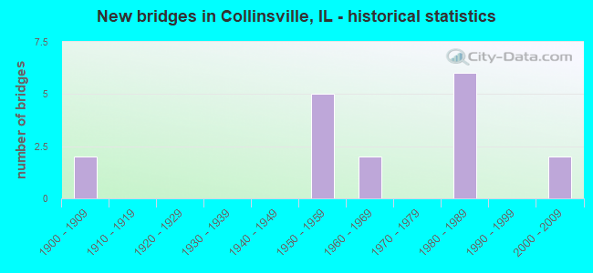
- New bridges - historical statistics
- 21900-1909
- 51950-1959
- 21960-1969
- 61980-1989
- 22000-2009
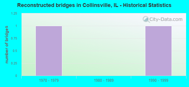
- Reconstructed bridges - Historical Statistics
- 11970-1979
- 01980-1989
- 11990-1999
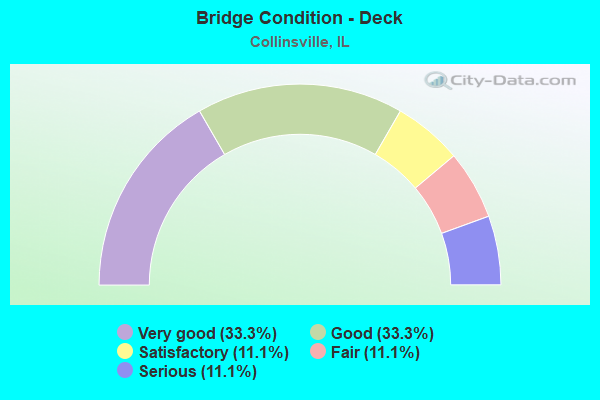
- Bridge Condition - Deck
- 33.3%Very good
- 33.3%Good
- 11.1%Satisfactory
- 11.1%Fair
- 11.1%Serious
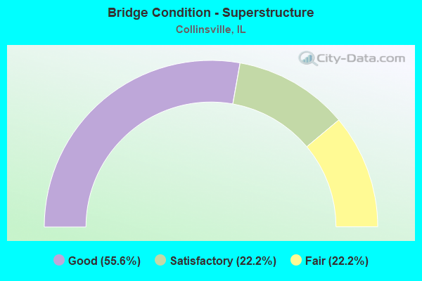
- Bridge Condition - Superstructure
- 55.6%Good
- 22.2%Satisfactory
- 22.2%Fair
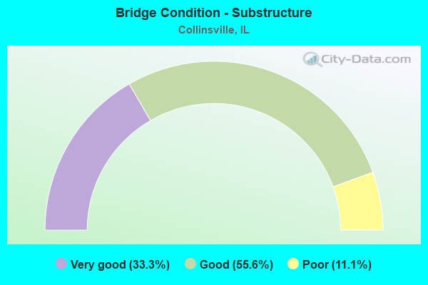
- Bridge Condition - Substructure
- 33.3%Very good
- 55.6%Good
- 11.1%Poor
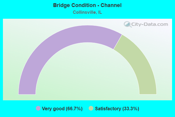
- Bridge Condition - Channel
- 66.7%Very good
- 33.3%Satisfactory
Find on map >> Show street view
Structure Number: 600016, Location: 1.5 M W 159 (Lat: 38.702311, Lng: -89.984806), Route carried "on" structure: Interstate 55, Year Built: 1959, Status: Open, Structure Length: 3.38m (11.09ft), Average Daily Traffic: 22,900 (year 2021), Truck Traffic: 25%, Average Future Daily Traffic: 21,041 (year 2032), Design Load: HS 20+Mod, Features Intersected: KEEBLER RD
Minimum Vertical Clearance: 30+ m (98+ ft), Kilometerpoint: 21.034, Lanes on structure: 2, Lanes under structure: 2, Base Highway Network: Yes, Owner: State Highway Agency, Approaching Roadway Width: 12.2m (40.0ft), Skew: 1 degrees, Material/Design: Concrete continuous, Design/Construction: Slab, Number Of Spans In Main Unit: 3, Length of Maximum Span: 13.1m (43.0ft), Curb-To-Curb Width: 11.9m (39.0ft), Out-to-Out Width: 13.3m (43.6ft)
Condition: Deck: Fair, Superstructure: Fair, Substructure: Good, Operating Rating: 61.6 metric tons, Method Used To Determine Operating Rating: Load Factor (LF) rating reported by rating factor (RF) method using MS18 loading, Inventory Rating: 36.9 metric tons, Method Used To Determine Inventory Rating: Load Factor (LF) rating reported by rating factor (RF) method using MS18 loading, Structural Evaluation: Somewhat better than minimum adequacy, Deck Geometry: Equal to present minimum criteria, Underclear: Meets minimum limits, Approach Roadway Alignment: Equal to present desirable criteria, Designated Inspection Frequency: Every 24 months, Inspection Date: December 2020, Deck Structure Type: Concrete Cast-file-Place, Wearing Surface/Protective System: Wearing Surface: Other
Find on map >> Show street view
Structure Number: 600081, Location: 2.15 MI WEST OF 157 (Lat: 38.668042, Lng: -90.047264), Route carried "on" structure: Other road , Year Built: 1960, Year Reconstructed: 1984, Status: Open, Structure Length: 7.45m (24.44ft), Average Daily Traffic: 475 (year 2021), Truck Traffic: 19%, Average Future Daily Traffic: 1,060 (year 2032), Design Load: HS 20, Features Intersected: FAI 70, Facility Carried by Structure: BLACK LANE ramp
Minimum Vertical Clearance: 30+ m (98+ ft), Kilometerpoint: 0.386, Lanes on structure: 1, Lanes under structure: 4, Base Highway Network: Yes (Inventory Route: 10070040, Subroute: 60), Owner: State Highway Agency, Approaching Roadway Width: 7.9m (25.9ft), Skew: 1 degrees, Material/Design: Steel, Design/Construction: Stringer/Multi-beam, Number Of Spans In Main Unit: 4, Length of Maximum Span: 24.8m (81.4ft), Curb-To-Curb Width: 6.7m (22.0ft), Out-to-Out Width: 8.4m (27.6ft)
Condition: Deck: Serious, Superstructure: Fair, Substructure: Poor, Operating Rating: 91.4 metric tons, Method Used To Determine Operating Rating: Load Factor (LF) rating reported by rating factor (RF) method using MS18 loading, Inventory Rating: 45.0 metric tons, Method Used To Determine Inventory Rating: Load Factor (LF) rating reported by rating factor (RF) method using MS18 loading, Structural Evaluation: Meets minimum limits, Deck Geometry: Meets minimum limits, Underclear: High priority of corrective action, Approach Roadway Alignment: Equal to present minimum criteria, Length Of Structure Improvement: 7.07m (23.20ft), Designated Inspection Frequency: Every 12 months, Inspection Date: August 2021, Bridge Improvement Cost: $451,000, Roadway Improvement Cost: $45,000, Total Project Cost: $496,000, Deck Structure Type: Concrete Cast-file-Place, Wearing Surface/Protective System: Wearing Surface: Bituminous, Membrane: Built-up
Find on map >> Show street view
Structure Number: 600172, Location: 0.7 M W ILL 159 (Lat: 38.705547, Lng: -89.971197), Route carried "on" structure: Other road , Year Built: 1959, Status: Open, Structure Length: 6.13m (20.11ft), Average Daily Traffic: 600 (year 2021), Truck Traffic: 6%, Average Future Daily Traffic: 742 (year 2032), Design Load: HS 20, Features Intersected: I-55/70, Facility Carried by Structure: PLEASNT RDG/FAU 91
Minimum Vertical Clearance: 30+ m (98+ ft), Kilometerpoint: 1.947, Lanes on structure: 2, Lanes under structure: 4, Owner: State Highway Agency, Approaching Roadway Width: 8.5m (27.9ft), Skew: 1 degrees, Material/Design: Concrete continuous, Design/Construction: Tee Beam, Number Of Spans In Main Unit: 4, Length of Maximum Span: 17.4m (57.1ft), Curb-To-Curb Width: 7.3m (24.0ft), Out-to-Out Width: 9.1m (29.9ft)
Condition: Deck: Satisfactory, Superstructure: Satisfactory, Substructure: Good, Operating Rating: 39.2 metric tons, Method Used To Determine Operating Rating: Load Factor (LF) rating reported by rating factor (RF) method using MS18 loading, Inventory Rating: 23.7 metric tons, Method Used To Determine Inventory Rating: Load Factor (LF) rating reported by rating factor (RF) method using MS18 loading, Structural Evaluation: Equal to present minimum criteria, Deck Geometry: Meets minimum limits, Underclear: High priority of corrective action, Approach Roadway Alignment: Equal to present minimum criteria, Length Of Structure Improvement: 6.13m (20.11ft), Designated Inspection Frequency: Every 12 months, Inspection Date: December 2021, Bridge Improvement Cost: $419,000, Roadway Improvement Cost: $42,000, Total Project Cost: $461,000, Deck Structure Type: Concrete Cast-file-Place, Wearing Surface/Protective System: Wearing Surface: Other
Find on map >> Show street view
Structure Number: 600215, Location: 1.2MI N FAI 55,70 (Lat: 38.683969, Lng: -90.030031), Route carried "on" structure: County highway , Year Built: 1986, Status: Open, Structure Length: 8.75m (28.71ft), Average Daily Traffic: 1,050 (year 2021), Truck Traffic: 15%, Average Future Daily Traffic: 1,060 (year 2032), Design Load: HS 20, Features Intersected: FAI 255, Facility Carried by Structure: TR 110-Fairmont Av
Minimum Vertical Clearance: 30+ m (98+ ft), Kilometerpoint: 0.402, Lanes on structure: 2, Lanes under structure: 6, Owner: State Highway Agency, Approaching Roadway Width: 6.7m (22.0ft), Material/Design: Steel continuous, Design/Construction: Stringer/Multi-beam, Number Of Spans In Main Unit: 2, Length of Maximum Span: 46.9m (153.9ft), Curb-To-Curb Width: 9.1m (29.9ft), Out-to-Out Width: 10.1m (33.1ft)
Condition: Deck: Good, Superstructure: Good, Substructure: Very good, Operating Rating: 54.1 metric tons, Method Used To Determine Operating Rating: Load Factor (LF) rating reported by rating factor (RF) method using MS18 loading, Inventory Rating: 32.4 metric tons, Method Used To Determine Inventory Rating: Load Factor (LF) rating reported by rating factor (RF) method using MS18 loading, Structural Evaluation: Better than present minimum criteria, Deck Geometry: Somewhat better than minimum adequacy, Underclear: Equal to present minimum criteria, Approach Roadway Alignment: Equal to present desirable criteria, Designated Inspection Frequency: Every 24 months, Inspection Date: January 2021, Deck Structure Type: Concrete Cast-file-Place, Wearing Surface/Protective System: Deck Protection: Epoxy Coated Reinforcing
Find on map >> Show street view
Structure Number: 603329, Location: .17 W. TR 361 (Lat: 38.676067, Lng: -89.952264), Route carried "on" structure: Other road , Year Built: 2003, Status: Open, Structure Length: 4.00m (13.12ft), Average Daily Traffic: 1,750 (year 2021), Truck Traffic: 9%, Average Future Daily Traffic: 2,014 (year 2032), Design Load: HS 20, Features Intersected: CANTEEN CREEK, Facility Carried by Structure: LEBANON RD/FAU 912
Minimum Vertical Clearance: 30+ m (98+ ft), Kilometerpoint: 5.826, Lanes on structure: 2, Owner: Town or Township Highway Agency, Approaching Roadway Width: 7.3m (24.0ft), Skew: 3 degrees, Material/Design: Steel continuous, Design/Construction: Stringer/Multi-beam, Number Of Spans In Main Unit: 3, Length of Maximum Span: 14.6m (47.9ft), Curb-To-Curb Width: 9.8m (32.2ft), Out-to-Out Width: 10.7m (35.1ft)
Condition: Deck: Very good, Superstructure: Good, Substructure: Very good, Channel: Satisfactory, Operating Rating: 87.2 metric tons, Method Used To Determine Operating Rating: Load Factor (LF) rating reported by rating factor (RF) method using MS18 loading, Inventory Rating: 52.2 metric tons, Method Used To Determine Inventory Rating: Load Factor (LF) rating reported by rating factor (RF) method using MS18 loading, Structural Evaluation: Better than present minimum criteria, Deck Geometry: Somewhat better than minimum adequacy, Waterway Adequacy: High priority of corrective action, Approach Roadway Alignment: Equal to present desirable criteria, Designated Inspection Frequency: Every 48 months, Inspection Date: August 2020, Deck Structure Type: Concrete Cast-file-Place, Wearing Surface/Protective System: Deck Protection: Epoxy Coated Reinforcing
Find on map >> Show street view
Structure Number: 60333, Location: 2M EAST 159 (Lat: 38.675547, Lng: -89.949497), Route carried "on" structure: Other road , Year Built: 2003, Status: Open, Structure Length: 1.36m (4.46ft), Average Daily Traffic: 1,750 (year 2021), Truck Traffic: 9%, Average Future Daily Traffic: 2,014 (year 2032), Design Load: HS 20, Features Intersected: CANTEEN CREEK, Facility Carried by Structure: LEBANON RD/FAU 912
Minimum Vertical Clearance: 30+ m (98+ ft), Kilometerpoint: 6.099, Lanes on structure: 2, Owner: Town or Township Highway Agency, Approaching Roadway Width: 7.3m (24.0ft), Skew: 5 degrees, Material/Design: Concrete, Design/Construction: Culvert, Number Of Spans In Main Unit: 2, Length of Maximum Span: 6.2m (20.3ft), Curb-To-Curb Width: 11.0m (36.1ft), Out-to-Out Width: 11.9m (39.0ft)
Condition: Channel: Satisfactory, Culverts: Good, Operating Rating: 62.5 metric tons, Method Used To Determine Operating Rating: Load Factor (LF) rating reported by rating factor (RF) method using MS18 loading, Inventory Rating: 37.6 metric tons, Method Used To Determine Inventory Rating: Load Factor (LF) rating reported by rating factor (RF) method using MS18 loading, Structural Evaluation: Better than present minimum criteria, Deck Geometry: Equal to present minimum criteria, Waterway Adequacy: Meets minimum limits, Approach Roadway Alignment: Equal to present minimum criteria, Designated Inspection Frequency: Every 48 months, Inspection Date: August 2020, Deck Structure Type: Concrete Cast-file-Place
Find on map >> Show street view
Structure Number: 820249, Location: 0.1MI S MAD CO LINE (Lat: 38.657133, Lng: -90.031703), Route carried "on" structure: Interstate 255, Year Built: 1984, Status: Open, Structure Length: 8.20m (26.90ft), Average Daily Traffic: 21,700 (year 2021), Truck Traffic: 15%, Average Future Daily Traffic: 24,215 (year 2032), Design Load: HS 20, Features Intersected: CANTEEN CREEK
Minimum Vertical Clearance: 30+ m (98+ ft), Kilometerpoint: 31.832, Lanes on structure: 3, Base Highway Network: Yes, Owner: State Highway Agency, Approaching Roadway Width: 17.1m (56.1ft), Material/Design: Steel continuous, Design/Construction: Stringer/Multi-beam, Number Of Spans In Main Unit: 3, Length of Maximum Span: 31.4m (103.0ft), Curb-To-Curb Width: 17.1m (56.1ft), Out-to-Out Width: 18.0m (59.1ft)
Condition: Deck: Very good, Superstructure: Good, Substructure: Good, Channel: Very good, Operating Rating: 89.1 metric tons, Method Used To Determine Operating Rating: Load Factor (LF) rating reported by rating factor (RF) method using MS18 loading, Inventory Rating: 48.0 metric tons, Method Used To Determine Inventory Rating: Load Factor (LF) rating reported by rating factor (RF) method using MS18 loading, Structural Evaluation: Better than present minimum criteria, Deck Geometry: Equal to present minimum criteria, Waterway Adequacy: Equal to present desirable criteria, Approach Roadway Alignment: Equal to present desirable criteria, Designated Inspection Frequency: Every 24 months, Inspection Date: January 2021, Deck Structure Type: Concrete Cast-file-Place, Wearing Surface/Protective System: Deck Protection: Epoxy Coated Reinforcing
Find on map >> Show street view
Structure Number: 82025, Location: 0.1MI S MAD CO LINE (Lat: 38.657256, Lng: -90.031667), Route carried "on" structure: Interstate 255, Year Built: 1984, Status: Open, Structure Length: 8.17m (26.80ft), Average Daily Traffic: 21,700 (year 2021), Truck Traffic: 15%, Average Future Daily Traffic: 24,215 (year 2032), Design Load: HS 20, Features Intersected: CANTEEN CREEK
Minimum Vertical Clearance: 30+ m (98+ ft), Kilometerpoint: 31.848, Lanes on structure: 3, Base Highway Network: Yes, Owner: State Highway Agency, Approaching Roadway Width: 17.1m (56.1ft), Material/Design: Steel continuous, Design/Construction: Stringer/Multi-beam, Number Of Spans In Main Unit: 3, Length of Maximum Span: 31.4m (103.0ft), Curb-To-Curb Width: 17.1m (56.1ft), Out-to-Out Width: 18.0m (59.1ft)
Condition: Deck: Very good, Superstructure: Good, Substructure: Very good, Channel: Very good, Operating Rating: 89.1 metric tons, Method Used To Determine Operating Rating: Load Factor (LF) rating reported by rating factor (RF) method using MS18 loading, Inventory Rating: 48.0 metric tons, Method Used To Determine Inventory Rating: Load Factor (LF) rating reported by rating factor (RF) method using MS18 loading, Structural Evaluation: Better than present minimum criteria, Deck Geometry: Equal to present minimum criteria, Waterway Adequacy: Equal to present desirable criteria, Approach Roadway Alignment: Equal to present desirable criteria, Designated Inspection Frequency: Every 24 months, Inspection Date: January 2021, Deck Structure Type: Concrete Cast-file-Place, Wearing Surface/Protective System: Deck Protection: Epoxy Coated Reinforcing
Find on map >> Show street view
Structure Number: 820266, Location: SO LIMITS COLLINSVIL (Lat: 38.654086, Lng: -89.988283), Route carried "on" structure: State highway 159, Year Built: 1980, Year Reconstructed: 2002, Status: Open, Structure Length: 16.00m (52.49ft), Average Daily Traffic: 16,100 (year 2021), Truck Traffic: 5%, Average Future Daily Traffic: 15,376 (year 2032), Design Load: HS 20, Features Intersected: CONRAIL
Minimum Vertical Clearance: 30+ m (98+ ft), Kilometerpoint: 49.953, Lanes on structure: 4, Base Highway Network: Yes, Owner: State Highway Agency, Approaching Roadway Width: 24.4m (80.1ft), Skew: 3 degrees, Material/Design: Steel continuous, Design/Construction: Stringer/Multi-beam, Number Of Spans In Main Unit: 7, Length of Maximum Span: 25.2m (82.7ft), Curb-To-Curb Width: 23.0m (75.5ft), Out-to-Out Width: 23.8m (78.1ft)
Condition: Deck: Good, Superstructure: Good, Substructure: Good, Channel: Very good, Operating Rating: 81.0 metric tons, Method Used To Determine Operating Rating: Load Factor (LF) rating reported by rating factor (RF) method using MS18 loading, Inventory Rating: 48.6 metric tons, Method Used To Determine Inventory Rating: Load Factor (LF) rating reported by rating factor (RF) method using MS18 loading, Structural Evaluation: Better than present minimum criteria, Deck Geometry: Superior to present desirable criteria, Underclear: Superior to present desirable criteria, Waterway Adequacy: Superior to present desirable criteria, Approach Roadway Alignment: Equal to present minimum criteria, Length Of Structure Improvement: 16.00m (52.49ft), Designated Inspection Frequency: Every 48 months, Inspection Date: April 2021, Bridge Improvement Cost: $368,550,000, Roadway Improvement Cost: $24,000,000, Total Project Cost: $368,790,000, Deck Structure Type: Concrete Cast-file-Place, Wearing Surface/Protective System: Wearing Surface: Other, Deck Protection: Epoxy Coated Reinforcing
Find on map >> Show street view
Structure Number: 82027, Location: I-255 SO OF CO LINE (Lat: 38.655431, Lng: -90.032850), Route carried "on" structure: Other road , Year Built: 1984, Status: Open, Structure Length: 9.30m (30.51ft), Average Daily Traffic: 2,350 (year 2016), Truck Traffic: 10%, Average Future Daily Traffic: 2,092 (year 2032), Design Load: HS 20+Mod, Features Intersected: CANTEEN CREEK, Facility Carried by Structure: FAI 255-RAMP 9
Minimum Vertical Clearance: 30+ m (98+ ft), Kilometerpoint: 0.563, Lanes on structure: 1, Base Highway Network: Yes (Inventory Route: 10255041, Subroute: 70), Owner: State Highway Agency, Approaching Roadway Width: 7.9m (25.9ft), Skew: 3 degrees, Material/Design: Steel continuous, Design/Construction: Stringer/Multi-beam, Number Of Spans In Main Unit: 3, Length of Maximum Span: 35.4m (116.1ft), Curb-To-Curb Width: 8.0m (26.2ft), Out-to-Out Width: 9.0m (29.5ft)
Condition: Deck: Good, Superstructure: Satisfactory, Substructure: Good, Channel: Very good, Operating Rating: 61.6 metric tons, Method Used To Determine Operating Rating: Load Factor (LF) rating reported by rating factor (RF) method using MS18 loading, Inventory Rating: 36.9 metric tons, Method Used To Determine Inventory Rating: Load Factor (LF) rating reported by rating factor (RF) method using MS18 loading, Structural Evaluation: Equal to present minimum criteria, Deck Geometry: High priority of corrective action, Waterway Adequacy: Equal to present desirable criteria, Approach Roadway Alignment: Equal to present desirable criteria, Designated Inspection Frequency: Every 24 months, Inspection Date: January 2021, Deck Structure Type: Concrete Cast-file-Place, Wearing Surface/Protective System: Wearing Surface: Bituminous, Membrane: Other, Deck Protection: Epoxy Coated Reinforcing
Find on map >> Show street view
Structure Number: 600016, Location: 1.5 M W 159 (Lat: 38.702311, Lng: -89.984806), Route carried "under" structure: Other road , Year Built: 1959, Structure Length: 0. m, Average Daily Traffic: 6,000 (year 2021), Truck Traffic: 4%, Features Intersected: KEEBLER RD, Facility Carried by Structure: I-55/70 EB
Minimum Vertical Clearance: 4.09m (13.42ft), Kilometerpoint: 3.862, Lanes on structure: 2, Lanes under structure: 2, Material/Design: Concrete continuous, Design/Construction: Slab, Length of Maximum Span: 13.1m (43.0ft)
Find on map >> Show street view
Structure Number: 600017, Location: 1.5 M WEST 159 (Lat: 38.702864, Lng: -89.984806), Route carried "under" structure: Other road , Year Built: 1959, Structure Length: 0. m, Average Daily Traffic: 6,000 (year 2021), Truck Traffic: 4%, Features Intersected: KEEBLER RD, Facility Carried by Structure: I-55/70 WB
Minimum Vertical Clearance: 4.09m (13.42ft), Kilometerpoint: 3.830, Lanes on structure: 2, Lanes under structure: 2, Material/Design: Concrete continuous, Design/Construction: Slab, Length of Maximum Span: 13.1m (43.0ft)
Find on map >> Show street view
Structure Number: 600081, Location: 2.15 MI WEST OF 157 (Lat: 38.667833, Lng: -90.047119), Route carried "under" structure: Interstate 55, Year Built: 1960, Structure Length: 0. m, Average Daily Traffic: 49,700 (year 2021), Truck Traffic: 17%, Features Intersected: FAI 70, Facility Carried by Structure: BLACK LANE ramp
Minimum Vertical Clearance: 4.65m (15.26ft), Kilometerpoint: 14.210, Lanes on structure: 1, Lanes under structure: 4, Material/Design: Steel, Design/Construction: Stringer/Multi-beam, Length of Maximum Span: 24.8m (81.4ft)
Find on map >> Show street view
Structure Number: 600172, Location: 0.7 M W ILL 159 (Lat: 38.705547, Lng: -89.971197), Route carried "under" structure: Interstate 55, Year Built: 1959, Structure Length: 0. m, Average Daily Traffic: 45,800 (year 2021), Truck Traffic: 25%, Features Intersected: I-55/70, Facility Carried by Structure: PLEASNT RDG/FAU 91
Minimum Vertical Clearance: 5.00m (16.40ft), Kilometerpoint: 22.289, Lanes on structure: 2, Lanes under structure: 4, Material/Design: Concrete continuous, Design/Construction: Tee Beam, Length of Maximum Span: 17.4m (57.1ft)
Find on map >> Show street view
Structure Number: 600215, Location: 1.2MI N FAI 55,70 (Lat: 38.683969, Lng: -90.030031), Route carried "under" structure: Interstate 255, Year Built: 1986, Structure Length: 0. m, Average Daily Traffic: 43,600 (year 2021), Truck Traffic: 11%, Features Intersected: FAI 255, Facility Carried by Structure: TR 110-Fairmont Av
Minimum Vertical Clearance: 5.23m (17.16ft), Kilometerpoint: 34.857, Lanes on structure: 2, Lanes under structure: 6, Material/Design: Steel continuous, Design/Construction: Stringer/Multi-beam, Length of Maximum Span: 46.9m (153.9ft)
Find on map >> Show street view
Structure Number: 609914, Location: E OF COLLINSVILLE (Lat: 38.672853, Lng: -89.944569), Route carried "under" structure: County highway , Year Built: 1900, Structure Length: 0. m, Average Daily Traffic: 950 (year 2021), Truck Traffic: 8%, Features Intersected: FAS 772, Facility Carried by Structure: CONRAIL
Minimum Vertical Clearance: 4.24m (13.91ft), Kilometerpoint: 0.515, Lanes under structure: 2, Material/Design: Concrete, Design/Construction: Slab, Length of Maximum Span: 6.1m (20.0ft)
Find on map >> Show street view
Structure Number: 609925, Location: E OF COLLINSVILLE (Lat: 38.672197, Lng: -89.937889), Route carried "under" structure: County highway , Year Built: 1900, Structure Length: 0. m, Average Daily Traffic: 275 (year 2021), Truck Traffic: 13%, Features Intersected: TR 387A, Facility Carried by Structure: CONRAIL
Minimum Vertical Clearance: 4.09m (13.42ft), Kilometerpoint: 0.064, Lanes under structure: 2, Material/Design: Concrete, Design/Construction: Slab, Length of Maximum Span: 6.1m (20.0ft)