Bridge Statistics for Colonial Park, Pennsylvania (PA)
Condition, Traffic, Stress, Structural Evaluation, Project Costs
- National Bridge Inventory (NBI) Statistics
- 27Number of bridges
- 180ft / 55.1mTotal length
- $6,325,000Total costs
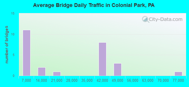
- 561,506Total average daily traffic
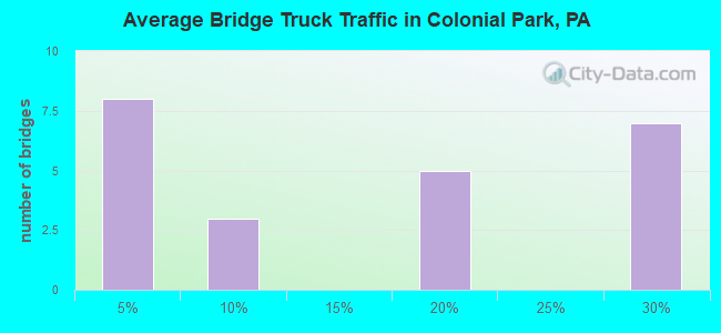
- 111,053Total average daily truck traffic
- National Bridge Inventory (NBI) Registered Bridges for Colonial Park
- No street view available for this location
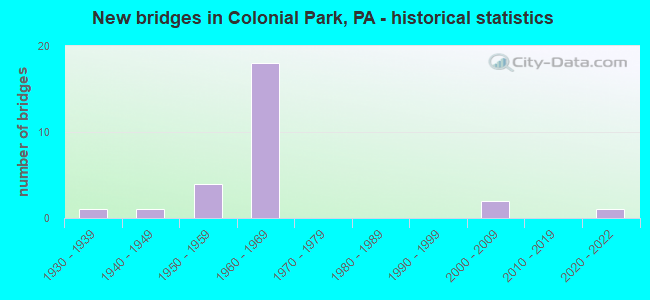
- New bridges - historical statistics
- 11930-1939
- 11940-1949
- 41950-1959
- 181960-1969
- 22000-2009
- 12020-2022
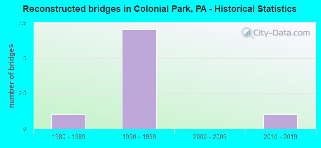
- Reconstructed bridges - Historical Statistics
- 11980-1989
- 71990-1999
- 02000-2009
- 12010-2019
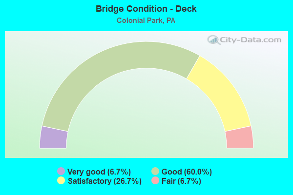
- Bridge Condition - Deck
- 6.7%Very good
- 60.0%Good
- 26.7%Satisfactory
- 6.7%Fair
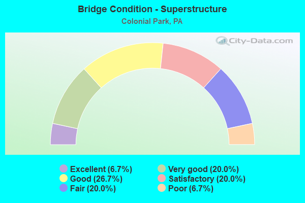
- Bridge Condition - Superstructure
- 6.7%Excellent
- 20.0%Very good
- 26.7%Good
- 20.0%Satisfactory
- 20.0%Fair
- 6.7%Poor
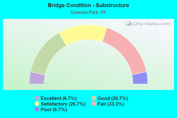
- Bridge Condition - Substructure
- 6.7%Excellent
- 26.7%Good
- 26.7%Satisfactory
- 33.3%Fair
- 6.7%Poor
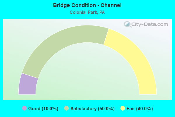
- Bridge Condition - Channel
- 10.0%Good
- 50.0%Satisfactory
- 40.0%Fair
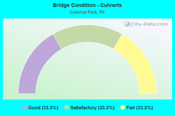
- Bridge Condition - Culverts
- 33.3%Good
- 33.3%Satisfactory
- 33.3%Fair
Find on map >> Show street view
Structure Number: 14228, Location: I-81& I-83 INTERCHANGE (Lat: 40.308606, Lng: -76.834339), Route carried "on" structure: Interstate 81, Year Built: 1969, Year Reconstructed: 2003, Status: Open, Structure Length: 4.85m (15.91ft), Average Daily Traffic: 36,585 (year 2021), Truck Traffic: 25%, Average Future Daily Traffic: 46,197 (year 2032), Design Load: HS 20, Features Intersected: I-83 NB; SR 0083
Minimum Vertical Clearance: 5.21m (17.09ft), Kilometerpoint: 7.580, Lanes on structure: 2, Lanes under structure: 2, Base Highway Network: Yes, Owner: State Highway Agency, Approaching Roadway Width: 15.8m (51.8ft), Skew: 2 degrees, Material/Design: Steel continuous, Design/Construction: Stringer/Multi-beam, Number Of Spans In Main Unit: 3, Length of Maximum Span: 20.7m (67.9ft), Curb or Sidewalk Widths: Left: 0.2m (0.7ft), Right: 0.2m (0.7ft), Curb-To-Curb Width: 15.2m (49.9ft), Out-to-Out Width: 16.3m (53.5ft)
Condition: Deck: Satisfactory, Superstructure: Good, Substructure: Satisfactory, Operating Rating: 68.0 metric tons, Method Used To Determine Operating Rating: Load Factor (LF), Inventory Rating: 40.8 metric tons, Method Used To Determine Inventory Rating: Load Factor (LF), Structural Evaluation: Equal to present minimum criteria, Deck Geometry: Superior to present desirable criteria, Underclear: Superior to present desirable criteria, Approach Roadway Alignment: Better than present minimum criteria, Length Of Structure Improvement: 5.80m (19.03ft), Designated Inspection Frequency: Every 24 months, Inspection Date: November 2020, Deck Structure Type: Concrete Cast-file-Place, Wearing Surface/Protective System: Wearing Surface: Monolithic Concrete, Deck Protection: Epoxy Coated Reinforcing
Find on map >> Show street view
Structure Number: 14229, Location: 1 MI. N. PROGRESS (Lat: 40.311053, Lng: -76.831631), Route carried "on" structure: Interstate 81, Year Built: 1969, Year Reconstructed: 2003, Status: Open, Structure Length: 3.29m (10.79ft), Average Daily Traffic: 36,585 (year 2021), Truck Traffic: 25%, Average Future Daily Traffic: 46,197 (year 2032), Design Load: HS 20, Features Intersected: TWP RD 432
Minimum Vertical Clearance: 30+ m (98+ ft), Kilometerpoint: 7.580, Lanes on structure: 2, Lanes under structure: 2, Base Highway Network: Yes, Owner: State Highway Agency, Approaching Roadway Width: 15.8m (51.8ft), Skew: 11 degrees, Material/Design: Prestressed concrete, Design/Construction: Box Beam or Girders - Single/Spread, Number Of Spans In Main Unit: 3, Length of Maximum Span: 10.7m (35.1ft), Curb or Sidewalk Widths: Left: 0.2m (0.7ft), Right: 0.2m (0.7ft), Curb-To-Curb Width: 16.0m (52.5ft), Out-to-Out Width: 16.9m (55.4ft)
Condition: Deck: Good, Superstructure: Good, Substructure: Satisfactory, Operating Rating: 69.9 metric tons, Method Used To Determine Operating Rating: Load Factor (LF), Inventory Rating: 40.8 metric tons, Method Used To Determine Inventory Rating: Load Factor (LF), Structural Evaluation: Equal to present minimum criteria, Deck Geometry: Superior to present desirable criteria, Underclear: Meets minimum limits, Approach Roadway Alignment: Equal to present desirable criteria, Length Of Structure Improvement: 4.10m (13.45ft), Designated Inspection Frequency: Every 24 months, Inspection Date: November 2020, Bridge Improvement Cost: $63,000, Roadway Improvement Cost: $186,000, Total Project Cost: $852,000, Deck Structure Type: Concrete Cast-file-Place, Wearing Surface/Protective System: Wearing Surface: Monolithic Concrete, Deck Protection: Epoxy Coated Reinforcing
Find on map >> Show street view
Structure Number: 14232, Location: 1 MI. N. PROGRESS (Lat: 40.311172, Lng: -76.833281), Route carried "on" structure: Interstate 81, Year Built: 1969, Year Reconstructed: 2003, Status: Open, Structure Length: 3.35m (10.99ft), Average Daily Traffic: 35,491 (year 2021), Truck Traffic: 25%, Average Future Daily Traffic: 47,266 (year 2032), Design Load: HS 20, Features Intersected: T-432,CRUMS MILL RD.
Minimum Vertical Clearance: 30+ m (98+ ft), Kilometerpoint: 7.525, Lanes on structure: 2, Lanes under structure: 2, Base Highway Network: Yes, Owner: State Highway Agency, Approaching Roadway Width: 15.8m (51.8ft), Skew: 12 degrees, Material/Design: Prestressed concrete, Design/Construction: Box Beam or Girders - Single/Spread, Number Of Spans In Main Unit: 3, Length of Maximum Span: 11.0m (36.1ft), Curb or Sidewalk Widths: Left: 0.2m (0.7ft), Right: 0.2m (0.7ft), Curb-To-Curb Width: 16.1m (52.8ft), Out-to-Out Width: 16.9m (55.4ft)
Condition: Deck: Good, Superstructure: Satisfactory, Substructure: Satisfactory, Operating Rating: 72.6 metric tons, Method Used To Determine Operating Rating: Load Factor (LF), Inventory Rating: 39.9 metric tons, Method Used To Determine Inventory Rating: Load Factor (LF), Structural Evaluation: Equal to present minimum criteria, Deck Geometry: Superior to present desirable criteria, Underclear: Equal to present minimum criteria, Approach Roadway Alignment: Equal to present desirable criteria, Length Of Structure Improvement: 4.20m (13.78ft), Designated Inspection Frequency: Every 24 months, Inspection Date: October 2020, Bridge Improvement Cost: $26,000, Roadway Improvement Cost: $77,000, Total Project Cost: $353,000, Deck Structure Type: Concrete Cast-file-Place, Wearing Surface/Protective System: Wearing Surface: Monolithic Concrete, Deck Protection: Epoxy Coated Reinforcing
Find on map >> Show street view
Structure Number: 14233, Location: 2.5 MI.S.W. LINGLESTOWN (Lat: 40.320333, Lng: -76.821358), Route carried "on" structure: Interstate 81, Year Built: 1969, Status: Open, Structure Length: 0.64m (2.10ft), Average Daily Traffic: 72,076 (year 2021), Truck Traffic: 25%, Average Future Daily Traffic: 93,463 (year 2032), Design Load: HS 20+Mod, Features Intersected: TRIB PAXTON CREEK
Minimum Vertical Clearance: 30+ m (98+ ft), Kilometerpoint: 9.193, Lanes on structure: 4, Base Highway Network: Yes, Owner: State Highway Agency, Approaching Roadway Width: 38.7m (127.0ft), Skew: 21 degrees, Material/Design: Concrete, Design/Construction: Culvert, Number Of Spans In Main Unit: 1, Length of Maximum Span: 6.4m (21.0ft)
Condition: Channel: Satisfactory, Culverts: Satisfactory, Operating Rating: 69.9 metric tons, Method Used To Determine Operating Rating: Load Factor (LF), Inventory Rating: 46.3 metric tons, Method Used To Determine Inventory Rating: Load Factor (LF), Structural Evaluation: Equal to present minimum criteria, Waterway Adequacy: Superior to present desirable criteria, Approach Roadway Alignment: Equal to present desirable criteria, Length Of Structure Improvement: 1.20m (3.94ft), Designated Inspection Frequency: Every 24 months, Inspection Date: November 2020
Find on map >> Show street view
Structure Number: 14289, Location: UPPER LEVEL (3LEV CROSS) (Lat: 40.308606, Lng: -76.834244), Route carried "on" structure: Interstate 83, Year Built: 1969, Year Reconstructed: 2004, Status: Open, Structure Length: 7.68m (25.20ft), Average Daily Traffic: 38,711 (year 2022), Truck Traffic: 18%, Average Future Daily Traffic: 49,799 (year 2032), Design Load: HS 20, Features Intersected: SR 0081 NB & SR 0083 NB
Minimum Vertical Clearance: 30+ m (98+ ft), Kilometerpoint: 12.712, Lanes on structure: 2, Lanes under structure: 8, Base Highway Network: Yes, Owner: State Highway Agency, Approaching Roadway Width: 11.6m (38.1ft), Skew: 2 degrees, Material/Design: Steel, Design/Construction: Stringer/Multi-beam, Number Of Spans In Main Unit: 1, Number Of Approach Spans: 2, Length of Maximum Span: 37.2m (122.0ft), Curb or Sidewalk Widths: Left: 0.2m (0.7ft), Right: 0.2m (0.7ft), Curb-To-Curb Width: 10.2m (33.5ft), Out-to-Out Width: 11.1m (36.4ft)
Condition: Deck: Good, Superstructure: Satisfactory, Substructure: Fair, Operating Rating: 88.9 metric tons, Method Used To Determine Operating Rating: Load Factor (LF), Inventory Rating: 52.6 metric tons, Method Used To Determine Inventory Rating: Load Factor (LF), Structural Evaluation: Somewhat better than minimum adequacy, Deck Geometry: Meets minimum limits, Underclear: Better than present minimum criteria, Approach Roadway Alignment: Equal to present desirable criteria, Length Of Structure Improvement: 8.60m (28.22ft), Designated Inspection Frequency: Every 24 months, Inspection Date: December 2020, Bridge Improvement Cost: $12,000, Roadway Improvement Cost: $34,000, Total Project Cost: $156,000, Deck Structure Type: Concrete Cast-file-Place, Wearing Surface/Protective System: Wearing Surface: Monolithic Concrete, Deck Protection: Epoxy Coated Reinforcing
Find on map >> Show street view
Structure Number: 1429, Location: 1 MI.N. PROGRESS (Lat: 40.311372, Lng: -76.832372), Route carried "on" structure: Interstate 83, Year Built: 1969, Year Reconstructed: 2003, Status: Open, Structure Length: 5.94m (19.49ft), Average Daily Traffic: 38,711 (year 2022), Truck Traffic: 18%, Average Future Daily Traffic: 49,799 (year 2032), Design Load: HS 20, Features Intersected: CRUMS MILL ROAD; T-432
Minimum Vertical Clearance: 30+ m (98+ ft), Kilometerpoint: 13.350, Lanes on structure: 2, Lanes under structure: 2, Base Highway Network: Yes, Owner: State Highway Agency, Approaching Roadway Width: 11.6m (38.1ft), Skew: 11 degrees, Material/Design: Prestressed concrete continuous, Design/Construction: Box Beam or Girders - Single/Spread, Number Of Spans In Main Unit: 3, Length of Maximum Span: 19.2m (63.0ft), Curb or Sidewalk Widths: Left: 0.2m (0.7ft), Right: 0.2m (0.7ft), Curb-To-Curb Width: 12.3m (40.4ft), Out-to-Out Width: 13.2m (43.3ft)
Condition: Deck: Good, Superstructure: Good, Substructure: Satisfactory, Operating Rating: 97.1 metric tons, Method Used To Determine Operating Rating: Load Factor (LF), Inventory Rating: 48.1 metric tons, Method Used To Determine Inventory Rating: Load Factor (LF), Structural Evaluation: Equal to present minimum criteria, Deck Geometry: Better than present minimum criteria, Underclear: Superior to present desirable criteria, Approach Roadway Alignment: Equal to present desirable criteria, Length Of Structure Improvement: 6.90m (22.64ft), Designated Inspection Frequency: Every 24 months, Inspection Date: November 2020, Bridge Improvement Cost: $59,000, Roadway Improvement Cost: $173,000, Total Project Cost: $793,000, Deck Structure Type: Concrete Cast-file-Place, Wearing Surface/Protective System: Wearing Surface: Monolithic Concrete, Deck Protection: Epoxy Coated Reinforcing
Find on map >> Show street view
Structure Number: 14545, Location: 1.5 NORTH OF PROGRESS (Lat: 40.318728, Lng: -76.823675), Route carried "on" structure: State highway , Year Built: 1968, Status: Open, Structure Length: 9.78m (32.09ft), Average Daily Traffic: 11,639 (year 2022), Truck Traffic: 2%, Average Future Daily Traffic: 17,786 (year 2032), Design Load: HS 20, Features Intersected: I-81; SR 0081, Facility Carried by Structure: SR 3017
Minimum Vertical Clearance: 30+ m (98+ ft), Kilometerpoint: 1.593, Lanes on structure: 2, Lanes under structure: 4, Owner: State Highway Agency, Approaching Roadway Width: 10.4m (34.1ft), Skew: 4 degrees, Material/Design: Steel, Design/Construction: Stringer/Multi-beam, Number Of Spans In Main Unit: 5, Length of Maximum Span: 23.5m (77.1ft), Curb or Sidewalk Widths: Left: 0.2m (0.7ft), Right: 0.2m (0.7ft), Curb-To-Curb Width: 10.2m (33.5ft), Out-to-Out Width: 11.4m (37.4ft)
Condition: Deck: Good, Superstructure: Fair, Substructure: Fair, Operating Rating: 59.0 metric tons, Method Used To Determine Operating Rating: Load Factor (LF), Inventory Rating: 35.4 metric tons, Method Used To Determine Inventory Rating: Load Factor (LF), Structural Evaluation: Somewhat better than minimum adequacy, Deck Geometry: Meets minimum limits, Underclear: Superior to present desirable criteria, Approach Roadway Alignment: Better than present minimum criteria, Length Of Structure Improvement: 10.90m (35.76ft), Designated Inspection Frequency: Every 24 months, Inspection Date: October 2020, Bridge Improvement Cost: $145,000, Roadway Improvement Cost: $426,000, Total Project Cost: $1,954,000, Deck Structure Type: Concrete Cast-file-Place, Wearing Surface/Protective System: Wearing Surface: Latex Concrete
Find on map >> Show street view
Structure Number: 14546, Location: 2 MI. N. OF PROGRESS (Lat: 40.321553, Lng: -76.823928), Route carried "on" structure: State highway , Year Built: 1959, Status: Open, Structure Length: 0.85m (2.79ft), Average Daily Traffic: 11,639 (year 2022), Truck Traffic: 2%, Average Future Daily Traffic: 17,786 (year 2032), Design Load: HS 20, Features Intersected: TRIB PAXTON CREEK, Facility Carried by Structure: SR 3017
Minimum Vertical Clearance: 30+ m (98+ ft), Kilometerpoint: 2.498, Lanes on structure: 2, Owner: State Highway Agency, Approaching Roadway Width: 9.8m (32.2ft), Skew: 3 degrees, Material/Design: Concrete, Design/Construction: Culvert, Number Of Spans In Main Unit: 1, Length of Maximum Span: 8.5m (27.9ft)
Condition: Channel: Fair, Culverts: Fair, Operating Rating: 69.9 metric tons, Method Used To Determine Operating Rating: Allowable Stress (AS), Inventory Rating: 46.3 metric tons, Method Used To Determine Inventory Rating: Allowable Stress (AS), Structural Evaluation: Somewhat better than minimum adequacy, Waterway Adequacy: Superior to present desirable criteria, Approach Roadway Alignment: Equal to present desirable criteria, Length Of Structure Improvement: 1.60m (5.25ft), Designated Inspection Frequency: Every 24 months, Inspection Date: October 2020
Find on map >> Show street view
Structure Number: 14678, Location: 1.5 SW LNGLSTN/TR PAX CR (Lat: 40.323233, Lng: -76.821236), Route carried "on" structure: City street , Year Built: 1960, Status: Open, Structure Length: 0.79m (2.59ft), Average Daily Traffic: 110 (year 2021), Truck Traffic: 7%, Average Future Daily Traffic: 420 (year 2041), Features Intersected: TRIB. PAXTON CREEK, Facility Carried by Structure: GERALDINE DR. T302
Minimum Vertical Clearance: 30+ m (98+ ft), Kilometerpoint: 0.000, Lanes on structure: 2, Owner: Town or Township Highway Agency, Approaching Roadway Width: 5.5m (18.0ft), Material/Design: Concrete, Design/Construction: Slab, Number Of Spans In Main Unit: 1, Length of Maximum Span: 7.6m (24.9ft), Curb or Sidewalk Widths: Left: 0.2m (0.7ft), Right: 0.2m (0.7ft), Curb-To-Curb Width: 9.2m (30.2ft), Out-to-Out Width: 10.5m (34.4ft)
Condition: Deck: Satisfactory, Superstructure: Satisfactory, Substructure: Fair, Channel: Fair, Operating Rating: 78.0 metric tons, Method Used To Determine Operating Rating: Field evaluation and documented engineering judgment, Inventory Rating: 46.3 metric tons, Method Used To Determine Inventory Rating: Field evaluation and documented engineering judgment, Structural Evaluation: Somewhat better than minimum adequacy, Deck Geometry: Equal to present minimum criteria, Waterway Adequacy: Better than present minimum criteria, Approach Roadway Alignment: Somewhat better than minimum adequacy, Length Of Structure Improvement: 1.40m (4.59ft), Designated Inspection Frequency: Every 24 months, Inspection Date: May 2021, Deck Structure Type: Concrete Cast-file-Place, Wearing Surface/Protective System: Wearing Surface: Monolithic Concrete
Find on map >> Show street view
Structure Number: 14683, Location: .3NW I/S 81&83/PAXTON CR (Lat: 40.314567, Lng: -76.839119), Route carried "on" structure: City street , Year Built: 1950, Year Reconstructed: 1980, Status: Open, Structure Length: 1.10m (3.61ft), Average Daily Traffic: 750 (year 2019), Truck Traffic: 1%, Average Future Daily Traffic: 1,050 (year 2039), Features Intersected: PAXTON CREEK, Facility Carried by Structure: CRUMS MILL RD T432
Minimum Vertical Clearance: 30+ m (98+ ft), Kilometerpoint: 0.000, Lanes on structure: 2, Owner: Town or Township Highway Agency, Approaching Roadway Width: 7.9m (25.9ft), Material/Design: Concrete, Design/Construction: Tee Beam, Number Of Spans In Main Unit: 1, Length of Maximum Span: 10.7m (35.1ft), Curb or Sidewalk Widths: Left: 1.2m (3.9ft), Right: 0.2m (0.7ft), Curb-To-Curb Width: 10.7m (35.1ft), Out-to-Out Width: 12.6m (41.3ft)
Condition: Deck: Satisfactory, Superstructure: Poor, Substructure: Fair, Channel: Satisfactory, Operating Rating: 47.2 metric tons, Method Used To Determine Operating Rating: Field evaluation and documented engineering judgment, Inventory Rating: 28.1 metric tons, Method Used To Determine Inventory Rating: Field evaluation and documented engineering judgment, Structural Evaluation: Meets minimum limits, Deck Geometry: Equal to present minimum criteria, Waterway Adequacy: Better than present minimum criteria, Approach Roadway Alignment: Somewhat better than minimum adequacy, Length Of Structure Improvement: 1.70m (5.58ft), Designated Inspection Frequency: Every 24 months, Other Special Inspection Frequency: Every 6 months, Inspection Date: May 2021, Other Special Inspection Date: May 2021, Deck Structure Type: Concrete Cast-file-Place, Wearing Surface/Protective System: Wearing Surface: Bituminous
Find on map >> Show street view
Structure Number: 14684, Location: 1.8N I/S 81&83/TR PXTN CR (Lat: 40.324358, Lng: -76.835142), Route carried "on" structure: City street , Year Built: 1950, Status: Closed, Structure Length: 0.88m (2.89ft), Average Daily Traffic: 150 (year 2021), Truck Traffic: 4%, Average Future Daily Traffic: 210 (year 2041), Features Intersected: TRIB PAXTON CREEK, Facility Carried by Structure: MCINTOSH ROAD T495
Minimum Vertical Clearance: 30+ m (98+ ft), Kilometerpoint: 0.000, Lanes on structure: 2, Owner: Town or Township Highway Agency, Approaching Roadway Width: 6.1m (20.0ft), Material/Design: Concrete, Design/Construction: Slab, Number Of Spans In Main Unit: 1, Length of Maximum Span: 8.2m (26.9ft), Curb or Sidewalk Widths: Left: 0.1m (0.3ft), Right: 0.1m (0.3ft), Curb-To-Curb Width: 6.1m (20.0ft), Out-to-Out Width: 7.0m (23.0ft)
Condition: Deck: Satisfactory, Superstructure: Fair, Substructure: Poor, Channel: Fair, Operating Rating: 75.3 metric tons, Method Used To Determine Operating Rating: Field evaluation and documented engineering judgment, Inventory Rating: 45.4 metric tons, Method Used To Determine Inventory Rating: Field evaluation and documented engineering judgment, Structural Evaluation: Meets minimum limits, Deck Geometry: Meets minimum limits, Waterway Adequacy: Better than present minimum criteria, Approach Roadway Alignment: Equal to present minimum criteria, Length Of Structure Improvement: 0.90m (2.95ft), Designated Inspection Frequency: Every 24 months, Other Special Inspection Frequency: Every 6 months, Inspection Date: May 2021, Other Special Inspection Date: May 2021, Deck Structure Type: Concrete Cast-file-Place, Wearing Surface/Protective System: Wearing Surface: Bituminous
Find on map >> Show street view
Structure Number: 14685, Location: 1 SW LNGLSTN/TR PAXTN CR (Lat: 40.326394, Lng: -76.814683), Route carried "on" structure: City street , Year Built: 1930, Status: Open, Structure Length: 0.73m (2.40ft), Average Daily Traffic: 750 (year 2021), Truck Traffic: 1%, Average Future Daily Traffic: 1,050 (year 2041), Features Intersected: TRIB PAXTON CREEK, Facility Carried by Structure: GOOSE VALLEY RD T5
Minimum Vertical Clearance: 30+ m (98+ ft), Kilometerpoint: 0.000, Lanes on structure: 2, Owner: Town or Township Highway Agency, Approaching Roadway Width: 5.8m (19.0ft), Skew: 2 degrees, Material/Design: Concrete, Design/Construction: Tee Beam, Number Of Spans In Main Unit: 1, Length of Maximum Span: 6.7m (22.0ft), Curb-To-Curb Width: 7.3m (24.0ft), Out-to-Out Width: 8.4m (27.6ft)
Condition: Deck: Fair, Superstructure: Fair, Substructure: Fair, Channel: Fair, Operating Rating: 58.1 metric tons, Method Used To Determine Operating Rating: Field evaluation and documented engineering judgment, Inventory Rating: 34.5 metric tons, Method Used To Determine Inventory Rating: Field evaluation and documented engineering judgment, Structural Evaluation: Somewhat better than minimum adequacy, Deck Geometry: Meets minimum limits, Waterway Adequacy: Better than present minimum criteria, Approach Roadway Alignment: Equal to present minimum criteria, Length Of Structure Improvement: 0.70m (2.30ft), Designated Inspection Frequency: Every 24 months, Inspection Date: May 2021, Bridge Improvement Cost: $10,000, Roadway Improvement Cost: $31,000, Total Project Cost: $140,000, Deck Structure Type: Concrete Cast-file-Place, Wearing Surface/Protective System: Wearing Surface: Bituminous
Find on map >> Show street view
Structure Number: 1477, Location: 1 MI. N. PROGRESS (Lat: 40.328333, Lng: -76.833333), Route carried "on" structure: Ramp State highway , Year Built: 1969, Year Reconstructed: 2003, Status: Open, Structure Length: 3.17m (10.40ft), Average Daily Traffic: 14,612 (year 2021), Truck Traffic: 7%, Average Future Daily Traffic: 20,526 (year 2032), Design Load: HS 20, Features Intersected: T-432,CRUMS MILL RD., Facility Carried by Structure: SR 8007, RAMP B
Minimum Vertical Clearance: 30+ m (98+ ft), Kilometerpoint: 0.000, Lanes on structure: 2, Lanes under structure: 2, Base Highway Network: Yes, Owner: State Highway Agency, Approaching Roadway Width: 11.6m (38.1ft), Material/Design: Prestressed concrete, Design/Construction: Box Beam or Girders - Single/Spread, Number Of Spans In Main Unit: 3, Length of Maximum Span: 11.3m (37.1ft), Curb or Sidewalk Widths: Left: 0.2m (0.7ft), Right: 0.2m (0.7ft), Curb-To-Curb Width: 12.3m (40.4ft), Out-to-Out Width: 13.2m (43.3ft)
Condition: Deck: Good, Superstructure: Good, Substructure: Good, Inventory Rating: 56.2 metric tons, Method Used To Determine Inventory Rating: Load Factor (LF), Structural Evaluation: Better than present minimum criteria, Deck Geometry: Superior to present desirable criteria, Underclear: High priority of corrective action, Approach Roadway Alignment: Equal to present desirable criteria, Length Of Structure Improvement: 4.00m (13.12ft), Designated Inspection Frequency: Every 24 months, Inspection Date: November 2020, Bridge Improvement Cost: $46,000, Roadway Improvement Cost: $135,000, Total Project Cost: $619,000, Deck Structure Type: Concrete Cast-file-Place, Wearing Surface/Protective System: Wearing Surface: Monolithic Concrete, Deck Protection: Epoxy Coated Reinforcing
Find on map >> Show street view
Structure Number: 31529, Location: 1.7 MI.S.OF SHANKSVILLE (Lat: 39.989531, Lng: -78.907308), Route carried "on" structure: State highway , Year Built: 1949, Year Reconstructed: 2010, Status: Open, Structure Length: 2.32m (7.61ft), Average Daily Traffic: 221 (year 2020), Truck Traffic: 2%, Average Future Daily Traffic: 283 (year 2032), Design Load: HL 93, Features Intersected: STONY CREEK, Facility Carried by Structure: SR 1007
Minimum Vertical Clearance: 30+ m (98+ ft), Kilometerpoint: 3.833, Lanes on structure: 2, Owner: State Highway Agency, Approaching Roadway Width: 5.5m (18.0ft), Material/Design: Steel, Design/Construction: Stringer/Multi-beam, Number Of Spans In Main Unit: 1, Length of Maximum Span: 22.3m (73.2ft), Curb or Sidewalk Widths: Left: 0.2m (0.7ft), Right: 0.2m (0.7ft), Curb-To-Curb Width: 7.3m (24.0ft), Out-to-Out Width: 8.4m (27.6ft)
Condition: Deck: Good, Superstructure: Very good, Substructure: Good, Channel: Satisfactory, Operating Rating: 78.9 metric tons, Method Used To Determine Operating Rating: Load Factor (LF), Inventory Rating: 47.2 metric tons, Method Used To Determine Inventory Rating: Load Factor (LF), Structural Evaluation: Better than present minimum criteria, Deck Geometry: Somewhat better than minimum adequacy, Waterway Adequacy: Better than present minimum criteria, Approach Roadway Alignment: Equal to present desirable criteria, Length Of Structure Improvement: 2.80m (9.19ft), Designated Inspection Frequency: Every 48 months, Inspection Date: April 2019, Bridge Improvement Cost: $74,000, Roadway Improvement Cost: $264,000, Total Project Cost: $997,000, Deck Structure Type: Concrete Cast-file-Place, Wearing Surface/Protective System: Wearing Surface: Monolithic Concrete, Deck Protection: Epoxy Coated Reinforcing
Find on map >> Show street view
Structure Number: 31573, Location: OGLETOWN (Lat: 40.199303, Lng: -78.704114), Route carried "on" structure: State highway , Year Built: 1952, Year Reconstructed: 2004, Status: Open, Structure Length: 0.70m (2.30ft), Average Daily Traffic: 488 (year 2020), Truck Traffic: 6%, Average Future Daily Traffic: 475 (year 2032), Design Load: HL 93, Features Intersected: BISCUIT SPRING RUN, Facility Carried by Structure: T840 MT CARMEL DR
Minimum Vertical Clearance: 30+ m (98+ ft), Kilometerpoint: 0.061, Lanes on structure: 2, Owner: State Highway Agency, Approaching Roadway Width: 7.3m (24.0ft), Material/Design: Steel, Design/Construction: Stringer/Multi-beam, Number Of Spans In Main Unit: 1, Length of Maximum Span: 6.7m (22.0ft), Curb-To-Curb Width: 7.4m (24.3ft), Out-to-Out Width: 7.9m (25.9ft)
Condition: Deck: Good, Superstructure: Very good, Substructure: Good, Channel: Satisfactory, Operating Rating: 68.0 metric tons, Method Used To Determine Operating Rating: Load and Resistance Factor (LRFR), Inventory Rating: 52.6 metric tons, Method Used To Determine Inventory Rating: Load and Resistance Factor (LRFR), Structural Evaluation: Better than present minimum criteria, Deck Geometry: Meets minimum limits, Waterway Adequacy: Better than present minimum criteria, Approach Roadway Alignment: Equal to present desirable criteria, Length Of Structure Improvement: 0.90m (2.95ft), Designated Inspection Frequency: Every 24 months, Inspection Date: May 2021, Bridge Improvement Cost: $34,000, Roadway Improvement Cost: $196,000, Total Project Cost: $461,000, Deck Structure Type: Concrete Cast-file-Place, Wearing Surface/Protective System: Wearing Surface: Monolithic Concrete, Deck Protection: Galvanized Reinforcing
Find on map >> Show street view
Structure Number: 42583, Location: 3 MI.N.W. HUMMELSTOWN (Lat: 40.287889, Lng: -76.763528), Route carried "on" structure: State highway , Year Built: 2004, Status: Open, Structure Length: 0.70m (2.30ft), Average Daily Traffic: 5,601 (year 2022), Truck Traffic: 3%, Average Future Daily Traffic: 6,241 (year 2032), Design Load: HS 25 or greater, Features Intersected: TRIB. TO NYE'S RUN, Facility Carried by Structure: SR 3020
Minimum Vertical Clearance: 30+ m (98+ ft), Kilometerpoint: 8.047, Lanes on structure: 2, Owner: State Highway Agency, Approaching Roadway Width: 27.4m (89.9ft), Skew: 2 degrees, Material/Design: Concrete, Design/Construction: Culvert, Number Of Spans In Main Unit: 1, Length of Maximum Span: 7.0m (23.0ft)
Condition: Channel: Good, Culverts: Good, Operating Rating: 89.8 metric tons, Method Used To Determine Operating Rating: Load Factor (LF), Inventory Rating: 85.3 metric tons, Method Used To Determine Inventory Rating: Load Factor (LF), Structural Evaluation: Better than present minimum criteria, Waterway Adequacy: Equal to present desirable criteria, Approach Roadway Alignment: Equal to present desirable criteria, Designated Inspection Frequency: Every 24 months, Inspection Date: October 2020
Find on map >> Show street view
Structure Number: 42584, Location: 3 MI.N.W.HUMMELSTOWN (Lat: 40.288389, Lng: -76.763083), Route carried "on" structure: State highway , Year Built: 2004, Status: Open, Structure Length: 2.77m (9.09ft), Average Daily Traffic: 5,601 (year 2022), Truck Traffic: 3%, Average Future Daily Traffic: 6,241 (year 2032), Design Load: HS 25 or greater, Features Intersected: TRIB. TO BEAVER CREEK, Facility Carried by Structure: SR 3020
Minimum Vertical Clearance: 30+ m (98+ ft), Kilometerpoint: 8.047, Lanes on structure: 2, Owner: State Highway Agency, Approaching Roadway Width: 14.6m (47.9ft), Skew: 2 degrees, Material/Design: Prestressed concrete, Design/Construction: Box Beam or Girders - Single/Spread, Number Of Spans In Main Unit: 1, Length of Maximum Span: 26.5m (86.9ft), Curb or Sidewalk Widths: Left: 0.2m (0.7ft), Right: 0.2m (0.7ft), Curb-To-Curb Width: 14.6m (47.9ft), Out-to-Out Width: 15.7m (51.5ft)
Condition: Deck: Good, Superstructure: Very good, Substructure: Good, Channel: Satisfactory, Operating Rating: 81.6 metric tons, Method Used To Determine Operating Rating: Load Factor (LF), Inventory Rating: 41.7 metric tons, Method Used To Determine Inventory Rating: Load Factor (LF), Structural Evaluation: Better than present minimum criteria, Deck Geometry: Superior to present desirable criteria, Waterway Adequacy: Equal to present desirable criteria, Approach Roadway Alignment: Equal to present desirable criteria, Designated Inspection Frequency: Every 24 months, Inspection Date: October 2020, Deck Structure Type: Concrete Cast-file-Place, Wearing Surface/Protective System: Wearing Surface: Monolithic Concrete, Deck Protection: Epoxy Coated Reinforcing
Find on map >> Show street view
Structure Number: 67834, Location: 1 MI. N. OF PROGRESS (Lat: 40.303983, Lng: -76.829739), Route carried "on" structure: Interstate 83, Year Built: 2020, Status: Open, Structure Length: 5.55m (18.21ft), Average Daily Traffic: 47,691 (year 2022), Truck Traffic: 16%, Average Future Daily Traffic: 50,213 (year 2032), Design Load: HL 93, Features Intersected: T-431, Valley Road
Minimum Vertical Clearance: 30+ m (98+ ft), Kilometerpoint: 12.025, Lanes on structure: 4, Lanes under structure: 2, Base Highway Network: Yes, Owner: State Highway Agency, Approaching Roadway Width: 27.1m (88.9ft), Skew: 12 degrees, Material/Design: Prestressed concrete, Design/Construction: Stringer/Multi-beam, Number Of Spans In Main Unit: 1, Length of Maximum Span: 39.3m (128.9ft), Curb or Sidewalk Widths: Left: 0.1m (0.3ft), Right: 0.1m (0.3ft), Curb-To-Curb Width: 26.1m (85.6ft), Out-to-Out Width: 27.2m (89.2ft)
Condition: Deck: Very good, Superstructure: Excellent, Substructure: Excellent, Operating Rating: 58.3 metric tons, Method Used To Determine Operating Rating: Assigned ratings based on Load and Resistance Factor Design (LRFD) reported by rating factor (RF) using HL93 loadings, Inventory Rating: 40.8 metric tons, Method Used To Determine Inventory Rating: Assigned ratings based on Load and Resistance Factor Design (LRFD) reported by rating factor (RF) using HL93 loadings, Structural Evaluation: Superior to present desirable criteria, Deck Geometry: Superior to present desirable criteria, Underclear: High priority of corrective action, Approach Roadway Alignment: Equal to present desirable criteria, Designated Inspection Frequency: Every 24 months, Inspection Date: November 2020, Deck Structure Type: Concrete Cast-file-Place, Wearing Surface/Protective System: Wearing Surface: Monolithic Concrete, Deck Protection: Epoxy Coated Reinforcing
Find on map >> Show street view
Structure Number: 14228, Location: I-81& I-83 INTERCHANGE (Lat: 40.308606, Lng: -76.834339), Route carried "under" structure: Interstate 83, Year Built: 1969, Structure Length: 0. m, Average Daily Traffic: 47,691 (year 2022), Truck Traffic: 16%, Features Intersected: I-83 NB; SR 0083, Facility Carried by Structure: I-81 NB; SR 0081
Minimum Vertical Clearance: 5.54m (18.18ft), Kilometerpoint: 12.789, Lanes on structure: 2, Lanes under structure: 2, Material/Design: Steel continuous, Design/Construction: Stringer/Multi-beam, Length of Maximum Span: 20.7m (67.9ft)
Find on map >> Show street view
Structure Number: 14229, Location: 1 MI. N. PROGRESS (Lat: 40.311053, Lng: -76.831631), Route carried "under" structure: City street T432, Year Built: 1969, Structure Length: 0. m, Features Intersected: TWP RD 432, Facility Carried by Structure: I-81 NB; SR 0081
Minimum Vertical Clearance: 5.11m (16.77ft), Kilometerpoint: 0.000, Lanes on structure: 2, Lanes under structure: 2, Material/Design: Prestressed concrete, Design/Construction: Box Beam or Girders - Single/Spread, Length of Maximum Span: 10.7m (35.1ft)
Find on map >> Show street view
Structure Number: 14232, Location: 1 MI. N. PROGRESS (Lat: 40.311172, Lng: -76.833281), Route carried "under" structure: City street T432, Year Built: 1969, Structure Length: 0. m, Average Daily Traffic: 1 (year 2005), Features Intersected: T-432,CRUMS MILL RD., Facility Carried by Structure: I-81 SB; SR 0081
Minimum Vertical Clearance: 4.79m (15.72ft), Kilometerpoint: 0.000, Lanes on structure: 2, Lanes under structure: 2, Material/Design: Prestressed concrete, Design/Construction: Box Beam or Girders - Single/Spread, Length of Maximum Span: 11.0m (36.1ft)
Find on map >> Show street view
Structure Number: 14289, Location: UPPER LEVEL (3LEV CROSS) (Lat: 40.308606, Lng: -76.834244), Route carried "under" structure: Interstate 83, Year Built: 1969, Structure Length: 0. m, Average Daily Traffic: 47,691 (year 2022), Truck Traffic: 16%, Features Intersected: SR 0081 NB & SR 0083 NB
Minimum Vertical Clearance: 5.54m (18.18ft), Kilometerpoint: 12.789, Lanes on structure: 2, Lanes under structure: 4, Material/Design: Steel, Design/Construction: Stringer/Multi-beam, Length of Maximum Span: 37.2m (122.0ft)
Find on map >> Show street view
Structure Number: 14289, Location: UPPER LEVEL (3LEV CROSS) (Lat: 40.308606, Lng: -76.834244), Route carried "under" structure: Interstate 81, Year Built: 1969, Structure Length: 0. m, Average Daily Traffic: 36,585 (year 2021), Truck Traffic: 25%, Features Intersected: SR 0081 NB & SR 0083 NB, Facility Carried by Structure: I-83 SB; SR 0083
Minimum Vertical Clearance: 5.31m (17.42ft), Kilometerpoint: 7.580, Lanes on structure: 2, Lanes under structure: 4, Material/Design: Steel, Design/Construction: Stringer/Multi-beam, Length of Maximum Span: 37.2m (122.0ft)
Find on map >> Show street view
Structure Number: 1429, Location: 1 MI.N. PROGRESS (Lat: 40.311372, Lng: -76.832372), Route carried "under" structure: City street , Year Built: 1969, Structure Length: 0. m, Average Daily Traffic: 1 (year 2005), Features Intersected: CRUMS MILL ROAD; T-432, Facility Carried by Structure: I-83 SB; SR 0083
Minimum Vertical Clearance: 11.34m (37.20ft), Kilometerpoint: 0.000, Lanes on structure: 2, Lanes under structure: 2, Material/Design: Prestressed concrete continuous, Design/Construction: Box Beam or Girders - Single/Spread, Length of Maximum Span: 19.2m (63.0ft)
Find on map >> Show street view
Structure Number: 14545, Location: 1.5 NORTH OF PROGRESS (Lat: 40.318728, Lng: -76.823675), Route carried "under" structure: Interstate 81, Year Built: 1968, Structure Length: 0. m, Average Daily Traffic: 36,585 (year 2021), Truck Traffic: 25%, Features Intersected: I-81; SR 0081, Facility Carried by Structure: SR 3017
Minimum Vertical Clearance: 5.84m (19.16ft), Kilometerpoint: 9.193, Lanes on structure: 2, Lanes under structure: 4, Material/Design: Steel, Design/Construction: Stringer/Multi-beam, Length of Maximum Span: 23.5m (77.1ft)
Find on map >> Show street view
Structure Number: 14545, Location: 1.5 NORTH OF PROGRESS (Lat: 40.318728, Lng: -76.823675), Route carried "under" structure: Interstate 81, Year Built: 1968, Structure Length: 0. m, Average Daily Traffic: 35,491 (year 2021), Truck Traffic: 25%, Features Intersected: I-81; SR 0081, Facility Carried by Structure: SR 3017
Minimum Vertical Clearance: 5.84m (19.16ft), Kilometerpoint: 9.112, Lanes on structure: 2, Lanes under structure: 4, Material/Design: Steel, Design/Construction: Stringer/Multi-beam, Length of Maximum Span: 23.5m (77.1ft)
Find on map >> Show street view
Structure Number: 1477, Location: 1 MI. N. PROGRESS (Lat: 40.328333, Lng: -76.833333), Route carried "under" structure: City street , Year Built: 1969, Structure Length: 0. m, Average Daily Traffic: 50 (year 1990), Features Intersected: T-432,CRUMS MILL RD., Facility Carried by Structure: SR 8007, RAMP B
Minimum Vertical Clearance: 4.91m (16.11ft), Kilometerpoint: 0.000, Lanes on structure: 2, Lanes under structure: 2, Material/Design: Prestressed concrete, Design/Construction: Box Beam or Girders - Single/Spread, Length of Maximum Span: 11.3m (37.1ft)