Bridge Statistics for Colonie, New York (NY)
Condition, Traffic, Stress, Structural Evaluation, Project Costs
- National Bridge Inventory (NBI) Statistics
- 19Number of bridges
- 187ft / 57.3mTotal length
- $44,653,000Total costs
- 459,023Total average daily traffic
- 30,213Total average daily truck traffic
- National Bridge Inventory (NBI) Registered Bridges for Colonie
- No street view available for this location
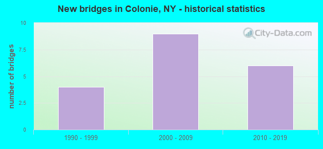
- New bridges - historical statistics
- 41990-1999
- 92000-2009
- 62010-2019
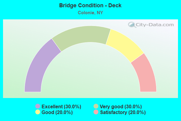
- Bridge Condition - Deck
- 30.0%Excellent
- 30.0%Very good
- 20.0%Good
- 20.0%Satisfactory
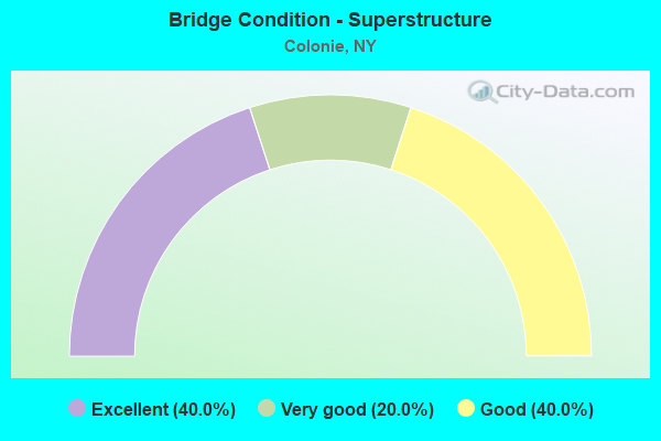
- Bridge Condition - Superstructure
- 40.0%Excellent
- 20.0%Very good
- 40.0%Good
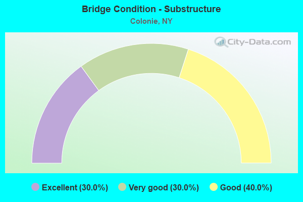
- Bridge Condition - Substructure
- 30.0%Excellent
- 30.0%Very good
- 40.0%Good
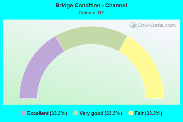
- Bridge Condition - Channel
- 33.3%Excellent
- 33.3%Very good
- 33.3%Fair
Find on map >> Show street view
Structure Number: 1002621, Location: JCT I87 & SH 5 IN COLONIE (Lat: 42.710711, Lng: -73.824964), Route carried "on" structure: Interstate 87, Year Built: 1998, Status: Open, Structure Length: 4.11m (13.48ft), Average Daily Traffic: 59,744 (year 2006), Truck Traffic: 7%, Design Load: HS 25 or greater, Features Intersected: RTE 5
Minimum Vertical Clearance: 30+ m (98+ ft), Kilometerpoint: 33.129, Lanes on structure: 4, Lanes under structure: 8, Base Highway Network: Yes, Owner: State Highway Agency, Approaching Roadway Width: 22.6m (74.1ft), Material/Design: Steel, Design/Construction: Stringer/Multi-beam, Number Of Spans In Main Unit: 1, Length of Maximum Span: 39.6m (129.9ft), Curb-To-Curb Width: 22.7m (74.5ft), Out-to-Out Width: 23.6m (77.4ft)
Condition: Deck: Good, Superstructure: Very good, Substructure: Good, Operating Rating: 89.8 metric tons, Method Used To Determine Operating Rating: Load Factor (LF), Inventory Rating: 64.4 metric tons, Method Used To Determine Inventory Rating: Load Factor (LF), Structural Evaluation: Better than present minimum criteria, Deck Geometry: Superior to present desirable criteria, Underclear: Meets minimum limits, Approach Roadway Alignment: Equal to present desirable criteria, Length Of Structure Improvement: 4.11m (13.48ft), Designated Inspection Frequency: Every 24 months, Inspection Date: April 2020, Bridge Improvement Cost: $2,947,000, Roadway Improvement Cost: $1,726,000, Total Project Cost: $4,673,000 ( Estimate for 2021), Deck Structure Type: Concrete Cast-file-Place, Wearing Surface/Protective System: Wearing Surface: Integral Concrete, Deck Protection: Epoxy Coated Reinforcing
Find on map >> Show street view
Structure Number: 1002622, Location: JCT I87 & SH 5 IN COLONIE (Lat: 42.710558, Lng: -73.824786), Route carried "on" structure: Interstate 87, Year Built: 1998, Status: Open, Structure Length: 4.11m (13.48ft), Average Daily Traffic: 43,877 (year 2013), Truck Traffic: 7%, Average Future Daily Traffic: 69,532 (year 2040), Design Load: HS 25 or greater, Features Intersected: RTE 5
Minimum Vertical Clearance: 30+ m (98+ ft), Kilometerpoint: 33.113, Lanes on structure: 4, Lanes under structure: 8, Base Highway Network: Yes, Owner: State Highway Agency, Approaching Roadway Width: 22.6m (74.1ft), Material/Design: Steel, Design/Construction: Stringer/Multi-beam, Number Of Spans In Main Unit: 1, Length of Maximum Span: 39.6m (129.9ft), Curb-To-Curb Width: 22.7m (74.5ft), Out-to-Out Width: 23.6m (77.4ft)
Condition: Deck: Good, Superstructure: Very good, Substructure: Good, Operating Rating: 89.8 metric tons, Method Used To Determine Operating Rating: Load Factor (LF), Inventory Rating: 64.4 metric tons, Method Used To Determine Inventory Rating: Load Factor (LF), Structural Evaluation: Better than present minimum criteria, Deck Geometry: Superior to present desirable criteria, Underclear: Meets minimum limits, Approach Roadway Alignment: Equal to present desirable criteria, Length Of Structure Improvement: 4.11m (13.48ft), Designated Inspection Frequency: Every 24 months, Inspection Date: April 2020, Bridge Improvement Cost: $2,947,000, Roadway Improvement Cost: $1,726,000, Total Project Cost: $4,673,000 ( Estimate for 2021), Deck Structure Type: Concrete Cast-file-Place, Wearing Surface/Protective System: Wearing Surface: Integral Concrete, Deck Protection: Epoxy Coated Reinforcing
Find on map >> Show street view
Structure Number: 1033131, Location: 0.8 MI NE JCT I87 & S H 5 (Lat: 42.718106, Lng: -73.814778), Route carried "on" structure: Interstate 87, Year Built: 2001, Status: Open, Structure Length: 2.80m (9.19ft), Average Daily Traffic: 47,706 (year 2015), Truck Traffic: 9%, Design Load: HS 25 or greater, Features Intersected: SAND CREEK ROAD
Minimum Vertical Clearance: 30+ m (98+ ft), Kilometerpoint: 3.218, Lanes on structure: 3, Lanes under structure: 2, Base Highway Network: Yes, Owner: State Highway Agency, Approaching Roadway Width: 19.2m (63.0ft), Material/Design: Prestressed concrete, Design/Construction: Box Beam or Girders - Multiple, Number Of Spans In Main Unit: 1, Length of Maximum Span: 27.0m (88.6ft), Curb-To-Curb Width: 19.3m (63.3ft), Out-to-Out Width: 20.2m (66.3ft)
Condition: Deck: Satisfactory, Superstructure: Good, Substructure: Very good, Operating Rating: 94.3 metric tons, Method Used To Determine Operating Rating: Load Factor (LF), Inventory Rating: 44.5 metric tons, Method Used To Determine Inventory Rating: Load Factor (LF), Structural Evaluation: Better than present minimum criteria, Deck Geometry: Superior to present desirable criteria, Underclear: High priority of corrective action, Approach Roadway Alignment: Equal to present desirable criteria, Length Of Structure Improvement: 2.80m (9.19ft), Designated Inspection Frequency: Every 24 months, Inspection Date: July 2021, Bridge Improvement Cost: $2,529,000, Roadway Improvement Cost: $1,481,000, Total Project Cost: $4,009,000 ( Estimate for 2021), Deck Structure Type: Concrete Cast-file-Place, Wearing Surface/Protective System: Wearing Surface: Monolithic Concrete, Deck Protection: Epoxy Coated Reinforcing
Find on map >> Show street view
Structure Number: 1033132, Location: 0.8 MI NE JCT I87 & S H 5 (Lat: 42.717753, Lng: -73.814275), Route carried "on" structure: Interstate 87, Year Built: 2001, Status: Open, Structure Length: 2.80m (9.19ft), Average Daily Traffic: 34,385 (year 2019), Truck Traffic: 9%, Average Future Daily Traffic: 54,489 (year 2040), Design Load: HS 25 or greater, Features Intersected: SAND CREEK ROAD
Minimum Vertical Clearance: 30+ m (98+ ft), Kilometerpoint: 34.288, Lanes on structure: 3, Lanes under structure: 2, Base Highway Network: Yes, Owner: State Highway Agency, Approaching Roadway Width: 19.2m (63.0ft), Material/Design: Prestressed concrete, Design/Construction: Box Beam or Girders - Multiple, Number Of Spans In Main Unit: 1, Length of Maximum Span: 27.0m (88.6ft), Curb-To-Curb Width: 19.3m (63.3ft), Out-to-Out Width: 20.2m (66.3ft)
Condition: Deck: Satisfactory, Superstructure: Good, Substructure: Very good, Operating Rating: 94.3 metric tons, Method Used To Determine Operating Rating: Load Factor (LF), Inventory Rating: 44.5 metric tons, Method Used To Determine Inventory Rating: Load Factor (LF), Structural Evaluation: Better than present minimum criteria, Deck Geometry: Superior to present desirable criteria, Underclear: High priority of corrective action, Approach Roadway Alignment: Equal to present desirable criteria, Length Of Structure Improvement: 2.74m (8.99ft), Designated Inspection Frequency: Every 24 months, Inspection Date: July 2021, Bridge Improvement Cost: $2,498,000, Roadway Improvement Cost: $1,463,000, Total Project Cost: $3,961,000 ( Estimate for 2021), Deck Structure Type: Concrete Cast-file-Place, Wearing Surface/Protective System: Wearing Surface: Monolithic Concrete, Deck Protection: Epoxy Coated Reinforcing
Find on map >> Show street view
Structure Number: 1033141, Location: JCT I87 & RTE 155 (Lat: 42.728400, Lng: -73.796181), Route carried "on" structure: Interstate 87, Year Built: 2015, Status: Open, Structure Length: 4.72m (15.49ft), Average Daily Traffic: 48,340 (year 2006), Truck Traffic: 9%, Design Load: HL 93, Features Intersected: ALBANY SHAKER RD
Minimum Vertical Clearance: 30+ m (98+ ft), Kilometerpoint: 36.219, Lanes on structure: 3, Lanes under structure: 5, Base Highway Network: Yes, Owner: State Highway Agency, Approaching Roadway Width: 20.7m (67.9ft), Skew: 1 degrees, Material/Design: Steel, Design/Construction: Stringer/Multi-beam, Number Of Spans In Main Unit: 1, Length of Maximum Span: 44.8m (147.0ft), Curb-To-Curb Width: 20.7m (67.9ft), Out-to-Out Width: 21.6m (70.9ft)
Condition: Deck: Excellent, Superstructure: Excellent, Substructure: Excellent, Operating Rating: 87.1 metric tons, Method Used To Determine Operating Rating: Load Factor (LF), Inventory Rating: 51.7 metric tons, Method Used To Determine Inventory Rating: Load Factor (LF), Structural Evaluation: Superior to present desirable criteria, Deck Geometry: Superior to present desirable criteria, Underclear: Better than present minimum criteria, Approach Roadway Alignment: Equal to present desirable criteria, Length Of Structure Improvement: 4.72m (15.49ft), Designated Inspection Frequency: Every 24 months, Inspection Date: October 2021, Bridge Improvement Cost: $2,799,000, Roadway Improvement Cost: $1,639,000, Total Project Cost: $4,438,000 ( Estimate for 2021), Deck Structure Type: Concrete Precast Panels, Wearing Surface/Protective System: Wearing Surface: Integral Concrete
Find on map >> Show street view
Structure Number: 1033142, Location: JCT I87 & RTE 155 (Lat: 42.728033, Lng: -73.795661), Route carried "on" structure: Interstate 87, Year Built: 2015, Status: Open, Structure Length: 4.72m (15.49ft), Average Daily Traffic: 36,180 (year 2019), Truck Traffic: 9%, Average Future Daily Traffic: 57,334 (year 2040), Design Load: Pedestrian, Features Intersected: ALBANY SHAKER RD
Minimum Vertical Clearance: 30+ m (98+ ft), Kilometerpoint: 36.203, Lanes on structure: 3, Lanes under structure: 5, Base Highway Network: Yes, Owner: State Highway Agency, Approaching Roadway Width: 20.7m (67.9ft), Skew: 1 degrees, Material/Design: Steel, Design/Construction: Stringer/Multi-beam, Number Of Spans In Main Unit: 1, Length of Maximum Span: 44.8m (147.0ft), Curb-To-Curb Width: 20.7m (67.9ft), Out-to-Out Width: 21.6m (70.9ft)
Condition: Deck: Excellent, Superstructure: Excellent, Substructure: Excellent, Operating Rating: 52.5 metric tons, Method Used To Determine Operating Rating: Load and Resistance Factor Rating (LRFR) rating reported by rating factor(RF) method using HL-93 loadings, Inventory Rating: 40.5 metric tons, Method Used To Determine Inventory Rating: Load and Resistance Factor Rating (LRFR) rating reported by rating factor(RF) method using HL-93 loadings, Structural Evaluation: Superior to present desirable criteria, Deck Geometry: Superior to present desirable criteria, Underclear: Equal to present minimum criteria, Approach Roadway Alignment: Equal to present desirable criteria, Length Of Structure Improvement: 4.72m (15.49ft), Designated Inspection Frequency: Every 24 months, Inspection Date: October 2021, Bridge Improvement Cost: $2,772,000, Roadway Improvement Cost: $1,623,000, Total Project Cost: $4,395,000 ( Estimate for 2021), Deck Structure Type: Concrete Precast Panels, Wearing Surface/Protective System: Wearing Surface: Integral Concrete
Find on map >> Show street view
Structure Number: 1034551, Location: 1.2 MI W JCT RTS 9 & 155 (Lat: 42.738372, Lng: -73.783586), Route carried "on" structure: Interstate 87, Year Built: 2007, Status: Open, Structure Length: 3.51m (11.52ft), Average Daily Traffic: 48,340 (year 2006), Truck Traffic: 9%, Design Load: HL 93, Features Intersected: RTE 155
Minimum Vertical Clearance: 30+ m (98+ ft), Kilometerpoint: 37.779, Lanes on structure: 4, Lanes under structure: 4, Base Highway Network: Yes, Owner: State Highway Agency, Approaching Roadway Width: 21.6m (70.9ft), Skew: 3 degrees, Material/Design: Prestressed concrete, Design/Construction: Box Beam or Girders - Multiple, Number Of Spans In Main Unit: 1, Length of Maximum Span: 33.4m (109.6ft), Curb-To-Curb Width: 21.6m (70.9ft), Out-to-Out Width: 22.7m (74.5ft)
Condition: Deck: Very good, Superstructure: Good, Substructure: Good, Operating Rating: 97.2 metric tons, Method Used To Determine Operating Rating: Load and Resistance Factor Rating (LRFR) rating reported by rating factor(RF) method using HL-93 loadings, Inventory Rating: 97.2 metric tons, Method Used To Determine Inventory Rating: Load and Resistance Factor Rating (LRFR) rating reported by rating factor(RF) method using HL-93 loadings, Structural Evaluation: Better than present minimum criteria, Deck Geometry: Better than present minimum criteria, Underclear: Somewhat better than minimum adequacy, Approach Roadway Alignment: Equal to present desirable criteria, Length Of Structure Improvement: 3.50m (11.48ft), Designated Inspection Frequency: Every 24 months, Inspection Date: March 2021, Bridge Improvement Cost: $3,557,000, Roadway Improvement Cost: $2,083,000, Total Project Cost: $5,641,000 ( Estimate for 2021), Deck Structure Type: Concrete Cast-file-Place, Wearing Surface/Protective System: Wearing Surface: Monolithic Concrete, Deck Protection: Epoxy Coated Reinforcing
Find on map >> Show street view
Structure Number: 1034552, Location: 1.2 MI W JCT RTS 9 & 155 (Lat: 42.738322, Lng: -73.782883), Route carried "on" structure: Interstate 87, Year Built: 2007, Status: Open, Structure Length: 3.51m (11.52ft), Average Daily Traffic: 36,180 (year 2018), Truck Traffic: 7%, Average Future Daily Traffic: 57,334 (year 2040), Design Load: HL 93, Features Intersected: RTE 155
Minimum Vertical Clearance: 30+ m (98+ ft), Kilometerpoint: 37.763, Lanes on structure: 4, Lanes under structure: 4, Base Highway Network: Yes, Owner: State Highway Agency, Approaching Roadway Width: 21.6m (70.9ft), Skew: 3 degrees, Material/Design: Prestressed concrete, Design/Construction: Box Beam or Girders - Multiple, Number Of Spans In Main Unit: 1, Length of Maximum Span: 33.4m (109.6ft), Curb-To-Curb Width: 21.6m (70.9ft), Out-to-Out Width: 22.7m (74.5ft)
Condition: Deck: Very good, Superstructure: Good, Substructure: Good, Operating Rating: 97.2 metric tons, Method Used To Determine Operating Rating: Load and Resistance Factor Rating (LRFR) rating reported by rating factor(RF) method using HL-93 loadings, Inventory Rating: 97.2 metric tons, Method Used To Determine Inventory Rating: Load and Resistance Factor Rating (LRFR) rating reported by rating factor(RF) method using HL-93 loadings, Structural Evaluation: Better than present minimum criteria, Deck Geometry: Better than present minimum criteria, Underclear: Meets minimum limits, Approach Roadway Alignment: Equal to present desirable criteria, Length Of Structure Improvement: 3.50m (11.48ft), Designated Inspection Frequency: Every 24 months, Inspection Date: March 2021, Bridge Improvement Cost: $3,597,000, Roadway Improvement Cost: $2,106,000, Total Project Cost: $5,703,000 ( Estimate for 2021), Deck Structure Type: Concrete Cast-file-Place, Wearing Surface/Protective System: Wearing Surface: Monolithic Concrete, Deck Protection: Epoxy Coated Reinforcing
Find on map >> Show street view
Structure Number: 108003, Location: Exit 3 flyover ramp (Lat: 42.725658, Lng: -73.801944), Route carried "on" structure: Ramp Interstate , Year Built: 2019, Status: Open, Structure Length: 11.19m (36.71ft), Design Load: HL 93, Features Intersected: I-87 SB, I-87, Facility Carried by Structure: Exit 3 Off-Ramp
Minimum Vertical Clearance: 32.69m (107.25ft), Kilometerpoint: 0.483, Lanes on structure: 1, Lanes under structure: 6, Owner: State Highway Agency, Approaching Roadway Width: 7.3m (24.0ft), Material/Design: Steel continuous, Design/Construction: Stringer/Multi-beam, Number Of Spans In Main Unit: 2, Length of Maximum Span: 54.9m (180.1ft), Curb-To-Curb Width: 7.3m (24.0ft), Out-to-Out Width: 8.2m (26.9ft)
Condition: Deck: Excellent, Superstructure: Excellent, Substructure: Excellent, Channel: Excellent, Operating Rating: 57.3 metric tons, Method Used To Determine Operating Rating: Load and Resistance Factor Rating (LRFR) rating reported by rating factor(RF) method using HL-93 loadings, Inventory Rating: 44.1 metric tons, Method Used To Determine Inventory Rating: Load and Resistance Factor Rating (LRFR) rating reported by rating factor(RF) method using HL-93 loadings, Structural Evaluation: Superior to present desirable criteria, Deck Geometry: Better than present minimum criteria, Underclear: Superior to present desirable criteria, Approach Roadway Alignment: Equal to present minimum criteria, Length Of Structure Improvement: 11.18m (36.68ft), Designated Inspection Frequency: Every 24 months, Inspection Date: August 2021, Bridge Improvement Cost: $2,188,000, Roadway Improvement Cost: $1,281,000, Total Project Cost: $3,469,000 ( Estimate for 2021), Deck Structure Type: Concrete Cast-file-Place, Wearing Surface/Protective System: Wearing Surface: Integral Concrete, Deck Protection: Epoxy Coated Reinforcing
Find on map >> Show street view
Structure Number: 226965, Location: 1 MI N OF ALBANY AIRPORT (Lat: 42.761392, Lng: -73.813089), Route carried "on" structure: County highway , Year Built: 2002, Status: Open, Structure Length: 1.31m (4.30ft), Average Daily Traffic: 899 (year 2018), Truck Traffic: 5%, Average Future Daily Traffic: 1,259 (year 2038), Design Load: HS 25 or greater, Features Intersected: SHAKER CREEK, Facility Carried by Structure: COUNTY ROAD 160
Minimum Vertical Clearance: 30+ m (98+ ft), Kilometerpoint: 0.097, Lanes on structure: 2, Owner: County Highway Agency, Approaching Roadway Width: 8.5m (27.9ft), Skew: 1 degrees, Material/Design: Concrete, Design/Construction: Culvert, Number Of Spans In Main Unit: 4, Length of Maximum Span: 3.0m (9.8ft), Curb-To-Curb Width: 8.4m (27.6ft), Out-to-Out Width: 10.0m (32.8ft)
Condition: Channel: Fair, Culverts: Satisfactory, Operating Rating: 74.3 metric tons, Method Used To Determine Operating Rating: Field evaluation and documented engineering judgment, Inventory Rating: 40.8 metric tons, Method Used To Determine Inventory Rating: Field evaluation and documented engineering judgment, Structural Evaluation: Equal to present minimum criteria, Deck Geometry: Somewhat better than minimum adequacy, Waterway Adequacy: Meets minimum limits, Approach Roadway Alignment: Equal to present minimum criteria, Length Of Structure Improvement: 1.31m (4.30ft), Designated Inspection Frequency: Every 24 months, Inspection Date: April 2021, Bridge Improvement Cost: $530,000, Roadway Improvement Cost: $310,000, Total Project Cost: $840,000 ( Estimate for 2021)
Find on map >> Show street view
Structure Number: 441601, Location: MOHAWK R & FERRY ROAD (Lat: 42.788372, Lng: -73.835486), Route carried "on" structure: Spur Other road , Year Built: 2010, Status: Open, Structure Length: 14.54m (47.70ft), Average Daily Traffic: 104 (year 2020), Truck Traffic: 5%, Average Future Daily Traffic: 146 (year 2040), Design Load: HL 93, Features Intersected: BACKCHANNELMOHAWK, BIKE, Facility Carried by Structure: FERRY RD.
Minimum Vertical Clearance: 30+ m (98+ ft), Kilometerpoint: 0.145, Lanes on structure: 1, Owner: State Highway Agency, Approaching Roadway Width: 4.3m (14.1ft), Material/Design: Steel continuous, Design/Construction: Stringer/Multi-beam, Number Of Spans In Main Unit: 4, Length of Maximum Span: 36.9m (121.1ft), Curb-To-Curb Width: 4.3m (14.1ft), Out-to-Out Width: 5.4m (17.7ft)
Condition: Deck: Very good, Superstructure: Excellent, Substructure: Very good, Channel: Very good, Operating Rating: 87.1 metric tons, Method Used To Determine Operating Rating: Load Factor (LF), Inventory Rating: 51.7 metric tons, Method Used To Determine Inventory Rating: Load Factor (LF), Structural Evaluation: Equal to present desirable criteria, Deck Geometry: High priority of replacement, Waterway Adequacy: Equal to present desirable criteria, Approach Roadway Alignment: Somewhat better than minimum adequacy, Length Of Structure Improvement: 14.53m (47.67ft), Designated Inspection Frequency: Every 24 months, Critical Feature Inspection Frequency: Every 24 months, Inspection Date: June 2020, Critical Feature Inspection Date: June 2020, Bridge Improvement Cost: $1,798,000, Roadway Improvement Cost: $1,053,000, Total Project Cost: $2,851,000 ( Estimate for 2021), Deck Structure Type: Concrete Cast-file-Place, Wearing Surface/Protective System: Wearing Surface: Integral Concrete, Deck Protection: Epoxy Coated Reinforcing
Find on map >> Show street view
Structure Number: 1002621, Location: JCT I87 & SH 5 IN COLONIE (Lat: 42.710711, Lng: -73.824964), Route carried "under" structure: State highway 5, Year Built: 1998, Structure Length: 0. m, Average Daily Traffic: 25,041 (year 1999), Features Intersected: RTE 5, Facility Carried by Structure: RTE I87
Minimum Vertical Clearance: 4.47m (14.67ft), Kilometerpoint: 7.884, Lanes on structure: 4, Lanes under structure: 8, Material/Design: Steel, Design/Construction: Stringer/Multi-beam, Length of Maximum Span: 39.6m (129.9ft)
Find on map >> Show street view
Structure Number: 1002622, Location: JCT I87 & SH 5 IN COLONIE (Lat: 42.710558, Lng: -73.824786), Route carried "under" structure: State highway 5, Year Built: 1998, Structure Length: 0. m, Average Daily Traffic: 25,041 (year 1999), Features Intersected: RTE 5, Facility Carried by Structure: RTE I87
Minimum Vertical Clearance: 4.88m (16.01ft), Kilometerpoint: 7.884, Lanes on structure: 4, Lanes under structure: 8, Material/Design: Steel, Design/Construction: Stringer/Multi-beam, Length of Maximum Span: 39.6m (129.9ft)
Find on map >> Show street view
Structure Number: 1033131, Location: 0.8 MI NE JCT I87 & S H 5 (Lat: 42.718106, Lng: -73.814778), Route carried "under" structure: Other road , Year Built: 2001, Structure Length: 0. m, Average Daily Traffic: 5,653 (year 2019), Truck Traffic: 2%, Features Intersected: SAND CREEK ROAD, Facility Carried by Structure: RTE I87
Minimum Vertical Clearance: 4.47m (14.67ft), Kilometerpoint: 0.338, Lanes on structure: 3, Lanes under structure: 2, Material/Design: Prestressed concrete, Design/Construction: Box Beam or Girders - Multiple, Length of Maximum Span: 27.0m (88.6ft)
Find on map >> Show street view
Structure Number: 1033132, Location: 0.8 MI NE JCT I87 & S H 5 (Lat: 42.717753, Lng: -73.814275), Route carried "under" structure: Other road , Year Built: 2001, Structure Length: 0. m, Average Daily Traffic: 5,653 (year 2019), Truck Traffic: 2%, Features Intersected: SAND CREEK ROAD, Facility Carried by Structure: RTE I87
Minimum Vertical Clearance: 4.50m (14.76ft), Kilometerpoint: 0.000, Lanes on structure: 3, Lanes under structure: 2, Material/Design: Prestressed concrete, Design/Construction: Box Beam or Girders - Multiple, Length of Maximum Span: 27.0m (88.6ft)
Find on map >> Show street view
Structure Number: 1033141, Location: JCT I87 & RTE 155 (Lat: 42.728400, Lng: -73.796181), Route carried "under" structure: Other road , Year Built: 2015, Structure Length: 0. m, Average Daily Traffic: 9,624 (year 2017), Truck Traffic: 5%, Features Intersected: ALBANY SHAKER RD, Facility Carried by Structure: RTE I87
Minimum Vertical Clearance: 5.03m (16.50ft), Kilometerpoint: 5.294, Lanes on structure: 3, Lanes under structure: 5, Material/Design: Steel, Design/Construction: Stringer/Multi-beam, Length of Maximum Span: 44.8m (147.0ft)
Find on map >> Show street view
Structure Number: 1033142, Location: JCT I87 & RTE 155 (Lat: 42.728033, Lng: -73.795661), Route carried "under" structure: Other road , Year Built: 2015, Structure Length: 0. m, Average Daily Traffic: 10,994 (year 2017), Truck Traffic: 3%, Features Intersected: ALBANY SHAKER RD, Facility Carried by Structure: RTE I87
Minimum Vertical Clearance: 5.36m (17.59ft), Kilometerpoint: 5.342, Lanes on structure: 3, Lanes under structure: 5, Material/Design: Steel, Design/Construction: Stringer/Multi-beam, Length of Maximum Span: 44.8m (147.0ft)
Find on map >> Show street view
Structure Number: 1034551, Location: 1.2 MI W JCT RTS 9 & 155 (Lat: 42.738372, Lng: -73.783586), Route carried "under" structure: State highway 155, Year Built: 2007, Structure Length: 0. m, Average Daily Traffic: 10,631 (year 2002), Features Intersected: RTE 155, Facility Carried by Structure: RTE I87
Minimum Vertical Clearance: 4.80m (15.75ft), Kilometerpoint: 9.429, Lanes on structure: 4, Lanes under structure: 4, Material/Design: Prestressed concrete, Design/Construction: Box Beam or Girders - Multiple, Length of Maximum Span: 33.4m (109.6ft)
Find on map >> Show street view
Structure Number: 1034552, Location: 1.2 MI W JCT RTS 9 & 155 (Lat: 42.738322, Lng: -73.782883), Route carried "under" structure: State highway 155, Year Built: 2007, Structure Length: 0. m, Average Daily Traffic: 10,631 (year 2002), Features Intersected: RTE 155, Facility Carried by Structure: RTE I87
Minimum Vertical Clearance: 4.55m (14.93ft), Kilometerpoint: 9.429, Lanes on structure: 4, Lanes under structure: 4, Material/Design: Prestressed concrete, Design/Construction: Box Beam or Girders - Multiple, Length of Maximum Span: 33.4m (109.6ft)