Bridge Statistics for Colton, South Dakota (SD)
Condition, Traffic, Stress, Structural Evaluation, Project Costs
- National Bridge Inventory (NBI) Statistics
- 10Number of bridges
- 52ft / 15.8mTotal length
- $4,058,000Total costs
- 6,587Total average daily traffic
- 269Total average daily truck traffic
- 7,940Total future (year 2032) average daily traffic
- National Bridge Inventory (NBI) Registered Bridges for Colton
- No street view available for this location
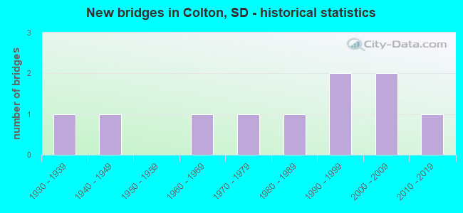
- New bridges - historical statistics
- 11930-1939
- 11940-1949
- 11960-1969
- 11970-1979
- 11980-1989
- 21990-1999
- 22000-2009
- 12010-2019

- Bridge Condition - Deck
- 50.0%Good
- 16.7%Satisfactory
- 16.7%Fair
- 16.7%Serious

- Bridge Condition - Superstructure
- 50.0%Good
- 16.7%Satisfactory
- 16.7%Fair
- 16.7%Poor

- Bridge Condition - Substructure
- 16.7%Very good
- 50.0%Good
- 33.3%Fair

- Bridge Condition - Channel
- 40.0%Very good
- 20.0%Good
- 20.0%Satisfactory
- 20.0%Fair

- Bridge Condition - Culverts
- 25.0%Very good
- 50.0%Good
- 25.0%Satisfactory
Find on map >> Show street view
Structure Number: 5009604, Location: 0.4W COLTON (Lat: 43.790297, Lng: -96.938147), Route carried "on" structure: County highway , Year Built: 2004, Status: Open, Structure Length: 0.63m (2.07ft), Average Daily Traffic: 861 (year 2020), Truck Traffic: 14%, Average Future Daily Traffic: 1,000 (year 2035), Features Intersected: COLTON CK, Facility Carried by Structure: 248TH ST, HWY 110
Minimum Vertical Clearance: 30+ m (98+ ft), Kilometerpoint: 0.000, Lanes on structure: 2, Owner: County Highway Agency, Approaching Roadway Width: 7.3m (24.0ft), Material/Design: Concrete continuous, Design/Construction: Culvert, Number Of Spans In Main Unit: 2, Length of Maximum Span: 3.3m (10.8ft)
Condition: Channel: Very good, Culverts: Good, Operating Rating: 32.7 metric tons, Method Used To Determine Operating Rating: Field evaluation and documented engineering judgment, Inventory Rating: 24.5 metric tons, Method Used To Determine Inventory Rating: Field evaluation and documented engineering judgment, Structural Evaluation: Equal to present minimum criteria, Waterway Adequacy: Better than present minimum criteria, Approach Roadway Alignment: Equal to present desirable criteria, Length Of Structure Improvement: 1.77m (5.81ft), Designated Inspection Frequency: Every 48 months, Inspection Date: July 2019, Bridge Improvement Cost: $115,000, Roadway Improvement Cost: $12,000, Total Project Cost: $237,000 ( Estimate for 2015)
Find on map >> Show street view
Structure Number: 50100051, Location: 1.1S COLTON (Lat: 43.774089, Lng: -96.930658), Route carried "on" structure: County highway , Year Built: 1947, Status: Open, Structure Length: 0.62m (2.03ft), Average Daily Traffic: 1,710 (year 2020), Truck Traffic: 3%, Average Future Daily Traffic: 2,000 (year 2035), Design Load: H 15, Features Intersected: COLTON CK, Facility Carried by Structure: 464TH AVE, HWY 149
Minimum Vertical Clearance: 30+ m (98+ ft), Kilometerpoint: 0.000, Lanes on structure: 2, Owner: County Highway Agency, Approaching Roadway Width: 7.3m (24.0ft), Skew: 2 degrees, Material/Design: Concrete continuous, Design/Construction: Culvert, Number Of Spans In Main Unit: 2, Length of Maximum Span: 3.2m (10.5ft)
Condition: Channel: Very good, Culverts: Satisfactory, Operating Rating: 44.1 metric tons, Method Used To Determine Operating Rating: Load Factor (LF), Inventory Rating: 26.5 metric tons, Method Used To Determine Inventory Rating: Load Factor (LF), Structural Evaluation: Equal to present minimum criteria, Waterway Adequacy: Better than present minimum criteria, Approach Roadway Alignment: Equal to present desirable criteria, Length Of Structure Improvement: 1.75m (5.74ft), Designated Inspection Frequency: Every 48 months, Inspection Date: July 2019, Bridge Improvement Cost: $114,000, Roadway Improvement Cost: $11,000, Total Project Cost: $230,000 ( Estimate for 2015)
Find on map >> Show street view
Structure Number: 50100066, Location: 2.6S COLTON (Lat: 43.752578, Lng: -96.930742), Route carried "on" structure: County highway , Year Built: 1930, Year Reconstructed: 1959, Status: Open, Structure Length: 0.63m (2.07ft), Average Daily Traffic: 1,061 (year 2020), Truck Traffic: 3%, Average Future Daily Traffic: 1,500 (year 2035), Features Intersected: TRIB TO COLTON CK, Facility Carried by Structure: 464TH AVE, HWY 149
Minimum Vertical Clearance: 30+ m (98+ ft), Kilometerpoint: 0.000, Lanes on structure: 2, Owner: County Highway Agency, Approaching Roadway Width: 7.3m (24.0ft), Material/Design: Concrete continuous, Design/Construction: Culvert, Number Of Spans In Main Unit: 2, Length of Maximum Span: 3.3m (10.8ft)
Condition: Channel: Satisfactory, Culverts: Good, Operating Rating: 32.7 metric tons, Method Used To Determine Operating Rating: Field evaluation and documented engineering judgment, Inventory Rating: 24.5 metric tons, Method Used To Determine Inventory Rating: Field evaluation and documented engineering judgment, Structural Evaluation: Equal to present minimum criteria, Waterway Adequacy: Equal to present desirable criteria, Approach Roadway Alignment: Equal to present desirable criteria, Length Of Structure Improvement: 1.65m (5.41ft), Designated Inspection Frequency: Every 48 months, Inspection Date: July 2019, Bridge Improvement Cost: $107,000, Roadway Improvement Cost: $11,000, Total Project Cost: $221,000 ( Estimate for 2015)
Find on map >> Show street view
Structure Number: 5010108, Location: 4S & 0.1E COLTON (Lat: 43.732294, Lng: -96.929794), Route carried "on" structure: County highway , Year Built: 1987, Status: Posted for load, Structure Length: 2.04m (6.69ft), Average Daily Traffic: 778 (year 2020), Truck Traffic: 3%, Average Future Daily Traffic: 900 (year 2035), Features Intersected: COLTON CK, Facility Carried by Structure: 252ND ST, HWY 118
Minimum Vertical Clearance: 30+ m (98+ ft), Kilometerpoint: 0.000, Lanes on structure: 2, Owner: County Highway Agency, Approaching Roadway Width: 7.3m (24.0ft), Material/Design: Prestressed concrete, Design/Construction: Tee Beam, Number Of Spans In Main Unit: 1, Length of Maximum Span: 19.8m (65.0ft), Curb-To-Curb Width: 9.7m (31.8ft), Out-to-Out Width: 9.8m (32.2ft)
Condition: Deck: Serious, Superstructure: Poor, Substructure: Fair, Channel: Satisfactory, Operating Rating: 24.5 metric tons, Method Used To Determine Operating Rating: Field evaluation and documented engineering judgment, Inventory Rating: 14.7 metric tons, Method Used To Determine Inventory Rating: Field evaluation and documented engineering judgment, Structural Evaluation: Meets minimum limits, Deck Geometry: Equal to present minimum criteria, Waterway Adequacy: Meets minimum limits, Approach Roadway Alignment: Equal to present desirable criteria, Bridge Posting: Required (Relationship of Operating Rating to Maximum Legal Load: 20.0 - 29.9% below), Length Of Structure Improvement: 2.80m (9.19ft), Designated Inspection Frequency: Every 24 months, Inspection Date: July 2021, Bridge Improvement Cost: $412,000, Roadway Improvement Cost: $41,000, Total Project Cost: $653,000 ( Estimate for 2017), Deck Structure Type: Concrete Precast Panels, Wearing Surface/Protective System: Wearing Surface: Bituminous
Find on map >> Show street view
Structure Number: 5010306, Location: 2S & 0.3E COLTON (Lat: 43.761261, Lng: -96.926389), Route carried "on" structure: County highway , Year Built: 2008, Status: Open, Structure Length: 0.63m (2.07ft), Average Daily Traffic: 862 (year 2019), Truck Traffic: 1%, Average Future Daily Traffic: 1,000 (year 2032), Features Intersected: COLTON CK, Facility Carried by Structure: 250TH ST, HWY 114
Minimum Vertical Clearance: 30+ m (98+ ft), Kilometerpoint: 0.000, Lanes on structure: 2, Owner: County Highway Agency, Approaching Roadway Width: 7.3m (24.0ft), Material/Design: Concrete continuous, Design/Construction: Culvert, Number Of Spans In Main Unit: 2, Length of Maximum Span: 3.3m (10.8ft)
Condition: Channel: Very good, Culverts: Very good, Operating Rating: 32.7 metric tons, Method Used To Determine Operating Rating: Field evaluation and documented engineering judgment, Inventory Rating: 24.5 metric tons, Method Used To Determine Inventory Rating: Field evaluation and documented engineering judgment, Structural Evaluation: Equal to present minimum criteria, Waterway Adequacy: Equal to present desirable criteria, Approach Roadway Alignment: Superior to present desirable criteria, Length Of Structure Improvement: 2.68m (8.79ft), Designated Inspection Frequency: Every 48 months, Inspection Date: July 2019, Bridge Improvement Cost: $175,000, Roadway Improvement Cost: $18,000, Total Project Cost: $324,000 ( Estimate for 2015)
Find on map >> Show street view
Structure Number: 5010309, Location: 5S & 0.3E COLTON (Lat: 43.717767, Lng: -96.924253), Route carried "on" structure: County highway , Year Built: 1978, Status: Open, Structure Length: 2.04m (6.69ft), Average Daily Traffic: 20 (year 2021), Truck Traffic: 2%, Average Future Daily Traffic: 25 (year 2036), Features Intersected: COLTON CK, Facility Carried by Structure: 253RD STREET
Minimum Vertical Clearance: 30+ m (98+ ft), Kilometerpoint: 0.000, Lanes on structure: 2, Owner: County Highway Agency, Approaching Roadway Width: 7.3m (24.0ft), Material/Design: Prestressed concrete, Design/Construction: Tee Beam, Number Of Spans In Main Unit: 1, Length of Maximum Span: 19.8m (65.0ft), Curb-To-Curb Width: 9.6m (31.5ft), Out-to-Out Width: 9.8m (32.2ft)
Condition: Deck: Good, Superstructure: Satisfactory, Substructure: Good, Channel: Fair, Operating Rating: 32.7 metric tons, Method Used To Determine Operating Rating: Field evaluation and documented engineering judgment, Inventory Rating: 19.6 metric tons, Method Used To Determine Inventory Rating: Field evaluation and documented engineering judgment, Structural Evaluation: Somewhat better than minimum adequacy, Deck Geometry: Better than present minimum criteria, Waterway Adequacy: Equal to present desirable criteria, Approach Roadway Alignment: Better than present minimum criteria, Length Of Structure Improvement: 2.80m (9.19ft), Designated Inspection Frequency: Every 24 months, Inspection Date: July 2021, Bridge Improvement Cost: $412,000, Roadway Improvement Cost: $41,000, Total Project Cost: $653,000 ( Estimate for 2017), Deck Structure Type: Concrete Precast Panels, Wearing Surface/Protective System: Wearing Surface: Monolithic Concrete
Find on map >> Show street view
Structure Number: 5010507, Location: 3S & 0.5E COLTON (Lat: 43.746750, Lng: -96.921503), Route carried "on" structure: County highway , Year Built: 1969, Status: Open, Structure Length: 1.89m (6.20ft), Average Daily Traffic: 13 (year 2021), Truck Traffic: 2%, Average Future Daily Traffic: 15 (year 2036), Features Intersected: COLTON CK, Facility Carried by Structure: 251ST STREET
Minimum Vertical Clearance: 30+ m (98+ ft), Kilometerpoint: 0.000, Lanes on structure: 2, Owner: County Highway Agency, Approaching Roadway Width: 6.1m (20.0ft), Material/Design: Concrete, Design/Construction: Channel Beam, Number Of Spans In Main Unit: 2, Length of Maximum Span: 9.1m (29.9ft), Curb-To-Curb Width: 7.4m (24.3ft), Out-to-Out Width: 7.8m (25.6ft)
Condition: Deck: Fair, Superstructure: Fair, Substructure: Fair, Channel: Good, Operating Rating: 32.7 metric tons, Method Used To Determine Operating Rating: Field evaluation and documented engineering judgment, Inventory Rating: 19.6 metric tons, Method Used To Determine Inventory Rating: Field evaluation and documented engineering judgment, Structural Evaluation: Somewhat better than minimum adequacy, Deck Geometry: Equal to present minimum criteria, Waterway Adequacy: Meets minimum limits, Approach Roadway Alignment: Better than present minimum criteria, Length Of Structure Improvement: 2.62m (8.60ft), Designated Inspection Frequency: Every 24 months, Inspection Date: July 2021, Bridge Improvement Cost: $385,000, Roadway Improvement Cost: $38,000, Total Project Cost: $609,000 ( Estimate for 2017), Deck Structure Type: Concrete Precast Panels, Wearing Surface/Protective System: Wearing Surface: Monolithic Concrete
Find on map >> Show street view
Structure Number: 5012906, Location: 2S & 2.9E COLTON (Lat: 43.761053, Lng: -96.872386), Route carried "on" structure: County highway , Year Built: 2017, Status: Open, Structure Length: 4.02m (13.19ft), Average Daily Traffic: 1,210 (year 2020), Truck Traffic: 3%, Average Future Daily Traffic: 1,400 (year 2035), Design Load: HL 93, Features Intersected: SKUNK CK, Facility Carried by Structure: 250TH ST, HWY 114
Minimum Vertical Clearance: 30+ m (98+ ft), Kilometerpoint: 0.000, Lanes on structure: 2, Owner: County Highway Agency, Approaching Roadway Width: 7.3m (24.0ft), Material/Design: Concrete continuous, Design/Construction: Slab, Number Of Spans In Main Unit: 3, Length of Maximum Span: 15.2m (49.9ft), Curb-To-Curb Width: 9.8m (32.2ft), Out-to-Out Width: 10.6m (34.8ft)
Condition: Deck: Good, Superstructure: Good, Substructure: Very good, Channel: Good, Operating Rating: 43.1 metric tons, Method Used To Determine Operating Rating: Load and Resistance Factor (LRFR), Inventory Rating: 33.2 metric tons, Method Used To Determine Inventory Rating: Load and Resistance Factor (LRFR), Structural Evaluation: Better than present minimum criteria, Deck Geometry: Somewhat better than minimum adequacy, Waterway Adequacy: Equal to present desirable criteria, Approach Roadway Alignment: Equal to present desirable criteria, Designated Inspection Frequency: Every 24 months, Inspection Date: July 2021, Deck Structure Type: Concrete Cast-file-Place, Wearing Surface/Protective System: Wearing Surface: Integral Concrete, Deck Protection: Epoxy Coated Reinforcing
Find on map >> Show street view
Structure Number: 5013105, Location: 1S & 3.1E COLTON (Lat: 43.775519, Lng: -96.868183), Route carried "on" structure: County highway , Year Built: 1999, Status: Open, Structure Length: 1.28m (4.20ft), Average Daily Traffic: 36 (year 2021), Truck Traffic: 2%, Average Future Daily Traffic: 50 (year 2036), Features Intersected: TRIB TO SKUNK CK, Facility Carried by Structure: 249TH STREET
Minimum Vertical Clearance: 30+ m (98+ ft), Kilometerpoint: 0.000, Lanes on structure: 2, Owner: County Highway Agency, Approaching Roadway Width: 7.3m (24.0ft), Material/Design: Prestressed concrete, Design/Construction: Tee Beam, Number Of Spans In Main Unit: 1, Length of Maximum Span: 12.2m (40.0ft), Curb-To-Curb Width: 9.8m (32.2ft), Out-to-Out Width: 10.2m (33.5ft)
Condition: Deck: Satisfactory, Superstructure: Good, Substructure: Good, Channel: Very good, Operating Rating: 32.7 metric tons, Method Used To Determine Operating Rating: Field evaluation and documented engineering judgment, Inventory Rating: 19.6 metric tons, Method Used To Determine Inventory Rating: Field evaluation and documented engineering judgment, Structural Evaluation: Somewhat better than minimum adequacy, Deck Geometry: Equal to present desirable criteria, Waterway Adequacy: Equal to present desirable criteria, Approach Roadway Alignment: Equal to present desirable criteria, Length Of Structure Improvement: 1.96m (6.43ft), Designated Inspection Frequency: Every 24 months, Inspection Date: July 2021, Bridge Improvement Cost: $288,000, Roadway Improvement Cost: $29,000, Total Project Cost: $478,000 ( Estimate for 2017), Deck Structure Type: Concrete Precast Panels, Wearing Surface/Protective System: Wearing Surface: Monolithic Concrete
Find on map >> Show street view
Structure Number: 5013305, Location: 1S & 3.3E COLTON (Lat: 43.775514, Lng: -96.864617), Route carried "on" structure: County highway , Year Built: 1990, Status: Open, Structure Length: 2.04m (6.69ft), Average Daily Traffic: 36 (year 2021), Truck Traffic: 2%, Average Future Daily Traffic: 50 (year 2036), Features Intersected: SKUNK CK, Facility Carried by Structure: 249TH STREET
Minimum Vertical Clearance: 30+ m (98+ ft), Kilometerpoint: 0.000, Lanes on structure: 2, Owner: County Highway Agency, Approaching Roadway Width: 7.3m (24.0ft), Material/Design: Prestressed concrete, Design/Construction: Tee Beam, Number Of Spans In Main Unit: 1, Length of Maximum Span: 19.8m (65.0ft), Curb-To-Curb Width: 9.7m (31.8ft), Out-to-Out Width: 9.8m (32.2ft)
Condition: Deck: Good, Superstructure: Good, Substructure: Good, Channel: Fair, Operating Rating: 32.7 metric tons, Method Used To Determine Operating Rating: Field evaluation and documented engineering judgment, Inventory Rating: 19.6 metric tons, Method Used To Determine Inventory Rating: Field evaluation and documented engineering judgment, Structural Evaluation: Somewhat better than minimum adequacy, Deck Geometry: Better than present minimum criteria, Waterway Adequacy: Equal to present minimum criteria, Approach Roadway Alignment: Equal to present desirable criteria, Length Of Structure Improvement: 2.80m (9.19ft), Designated Inspection Frequency: Every 24 months, Inspection Date: July 2021, Bridge Improvement Cost: $412,000, Roadway Improvement Cost: $41,000, Total Project Cost: $653,000 ( Estimate for 2017), Deck Structure Type: Concrete Precast Panels, Wearing Surface/Protective System: Wearing Surface: Monolithic Concrete