Bridge Statistics for Columbia, New Jersey (NJ)
Condition, Traffic, Stress, Structural Evaluation, Project Costs
- National Bridge Inventory (NBI) Statistics
- 22Number of bridges
- 167ft / 50.5mTotal length
- $5,395,000Total costs
- 237,985Total average daily traffic
- 26,102Total average daily truck traffic
- National Bridge Inventory (NBI) Registered Bridges for Columbia
- No street view available for this location
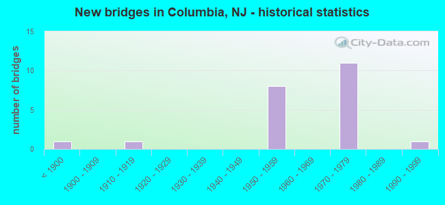
- New bridges - historical statistics
- 1Before 1900
- 11910-1919
- 81950-1959
- 111970-1979
- 11990-1999

- Reconstructed bridges - Historical Statistics
- 51980-1989
- 11990-1999


- Bridge Condition - Deck
- 25.0%Good
- 58.3%Satisfactory
- 16.7%Fair

- Bridge Condition - Superstructure
- 61.5%Good
- 23.1%Satisfactory
- 15.4%Fair

- Bridge Condition - Substructure
- 30.8%Good
- 46.2%Satisfactory
- 23.1%Fair

- Bridge Condition - Channel
- 40.0%Good
- 40.0%Satisfactory
- 20.0%Fair
Find on map >> Show street view
Structure Number: 210131, Location: 0.41 MI SOUTH OF NJ 94 (Lat: 40.933150, Lng: -75.075419), Route carried "on" structure: County highway 605, Year Built: 1886, Year Reconstructed: 1990, Status: Open, Structure Length: 3.51m (11.52ft), Average Daily Traffic: 260 (year 2021), Truck Traffic: 3%, Average Future Daily Traffic: 310 (year 2041), Design Load: HS 20+Mod, Features Intersected: PAULINS KILL
Minimum Vertical Clearance: 30+ m (98+ ft), Kilometerpoint: 6.357, Lanes on structure: 2, Owner: County Highway Agency, Approaching Roadway Width: 6.1m (20.0ft), Material/Design: Steel, Design/Construction: Truss - Thru, Number Of Spans In Main Unit: 1, Length of Maximum Span: 33.8m (110.9ft), Curb-To-Curb Width: 6.0m (19.7ft), Out-to-Out Width: 6.6m (21.7ft)
Condition: Deck: Fair, Superstructure: Fair, Substructure: Good, Channel: Satisfactory, Operating Rating: 62.6 metric tons, Method Used To Determine Operating Rating: Load Factor (LF), Inventory Rating: 37.2 metric tons, Method Used To Determine Inventory Rating: Load Factor (LF), Structural Evaluation: Somewhat better than minimum adequacy, Deck Geometry: High priority of corrective action, Waterway Adequacy: Better than present minimum criteria, Approach Roadway Alignment: Meets minimum limits, Designated Inspection Frequency: Every 24 months, Critical Feature Inspection Frequency: Every 24 months, Inspection Date: March 2021, Critical Feature Inspection Date: March 2021, Deck Structure Type: Wood or Timber, Wearing Surface/Protective System: Wearing Surface: Bituminous, Membrane: Preformed Fabric
Find on map >> Show street view
Structure Number: 210135, Location: 0.5 MILE EAST OF I-80 (Lat: 40.943931, Lng: -75.096789), Route carried "on" structure: City street , Year Built: 1950, Status: Open, Structure Length: 1.04m (3.41ft), Average Daily Traffic: 320 (year 2021), Truck Traffic: 3%, Average Future Daily Traffic: 400 (year 2041), Features Intersected: STONY BROOK, Facility Carried by Structure: HAINSBURG RIVER RD
Minimum Vertical Clearance: 30+ m (98+ ft), Kilometerpoint: 0.000, Lanes on structure: 2, Owner: County Highway Agency, Approaching Roadway Width: 7.3m (24.0ft), Material/Design: Steel, Design/Construction: Stringer/Multi-beam, Number Of Spans In Main Unit: 1, Length of Maximum Span: 9.1m (29.9ft), Curb-To-Curb Width: 7.8m (25.6ft), Out-to-Out Width: 8.9m (29.2ft)
Condition: Deck: Satisfactory, Superstructure: Satisfactory, Substructure: Good, Channel: Satisfactory, Operating Rating: 78.9 metric tons, Method Used To Determine Operating Rating: Load Factor (LF), Inventory Rating: 47.2 metric tons, Method Used To Determine Inventory Rating: Load Factor (LF), Structural Evaluation: Equal to present minimum criteria, Deck Geometry: Somewhat better than minimum adequacy, Waterway Adequacy: Better than present minimum criteria, Approach Roadway Alignment: Equal to present minimum criteria, Designated Inspection Frequency: Every 24 months, Inspection Date: March 2021, Deck Structure Type: Concrete Cast-file-Place, Wearing Surface/Protective System: Wearing Surface: Bituminous, Membrane: Preformed Fabric
Find on map >> Show street view
Structure Number: 2101356, Location: 0.5 MILE EAST OF ROUTE 80 (Lat: 40.943839, Lng: -75.096189), Route carried "on" structure: City street , Year Built: 1995, Status: Open, Structure Length: 1.71m (5.61ft), Average Daily Traffic: 316 (year 2021), Truck Traffic: 3%, Average Future Daily Traffic: 380 (year 2041), Design Load: HS 25 or greater, Features Intersected: STONY BROOK, Facility Carried by Structure: SADIE CANN ROAD
Minimum Vertical Clearance: 30+ m (98+ ft), Kilometerpoint: 0.000, Lanes on structure: 2, Owner: County Highway Agency, Approaching Roadway Width: 8.5m (27.9ft), Material/Design: Prestressed concrete, Design/Construction: Box Beam or Girders - Multiple, Number Of Spans In Main Unit: 1, Length of Maximum Span: 15.5m (50.9ft), Curb-To-Curb Width: 8.8m (28.9ft), Out-to-Out Width: 10.0m (32.8ft)
Condition: Deck: Satisfactory, Superstructure: Satisfactory, Substructure: Good, Channel: Fair, Inventory Rating: 59.0 metric tons, Method Used To Determine Inventory Rating: Load Factor (LF), Structural Evaluation: Equal to present minimum criteria, Deck Geometry: Equal to present minimum criteria, Waterway Adequacy: Superior to present desirable criteria, Approach Roadway Alignment: Meets minimum limits, Designated Inspection Frequency: Every 24 months, Inspection Date: April 2021, Deck Structure Type: Concrete Cast-file-Place, Wearing Surface/Protective System: Deck Protection: Epoxy Coated Reinforcing
Find on map >> Show street view
Structure Number: 2107158, Location: I-80 / US 46 INTERSECTION (Lat: 40.928469, Lng: -75.090031), Route carried "on" structure: US 46, Year Built: 1973, Status: Open, Structure Length: 3.29m (10.79ft), Average Daily Traffic: 5,043 (year 2021), Truck Traffic: 7%, Average Future Daily Traffic: 6,052 (year 2041), Design Load: HS 20+Mod, Features Intersected: NJ 94 SOUTHBOUND
Minimum Vertical Clearance: 30+ m (98+ ft), Kilometerpoint: 0.467, Lanes on structure: 1, Lanes under structure: 2, Base Highway Network: Yes, Owner: State Highway Agency, Approaching Roadway Width: 7.9m (25.9ft), Skew: 3 degrees, Material/Design: Steel, Design/Construction: Stringer/Multi-beam, Number Of Spans In Main Unit: 1, Length of Maximum Span: 30.8m (101.0ft), Curb or Sidewalk Widths: Left: 0.8m (2.6ft), Right: 0.8m (2.6ft), Curb-To-Curb Width: 8.0m (26.2ft), Out-to-Out Width: 10.2m (33.5ft)
Condition: Deck: Fair, Superstructure: Good, Substructure: Fair, Operating Rating: 88.9 metric tons, Method Used To Determine Operating Rating: Load Factor (LF), Inventory Rating: 53.5 metric tons, Method Used To Determine Inventory Rating: Load Factor (LF), Structural Evaluation: Somewhat better than minimum adequacy, Deck Geometry: High priority of replacement, Underclear: Meets minimum limits, Approach Roadway Alignment: Better than present minimum criteria, Length Of Structure Improvement: 3.29m (10.79ft), Designated Inspection Frequency: Every 24 months, Inspection Date: March 2021, Bridge Improvement Cost: $414,000, Roadway Improvement Cost: $56,000, Total Project Cost: $677,000 ( Estimate for 2021), Deck Structure Type: Concrete Cast-file-Place, Wearing Surface/Protective System: Wearing Surface: Monolithic Concrete
Find on map >> Show street view
Structure Number: 211416, Location: 0.38 MI W OF NJ 94 JCT (Lat: 40.930231, Lng: -75.097400), Route carried "on" structure: City street , Year Built: 1953, Status: Open, Structure Length: 3.99m (13.09ft), Average Daily Traffic: 1,544 (year 2021), Truck Traffic: 3%, Average Future Daily Traffic: 1,854 (year 2041), Design Load: HS 20, Features Intersected: I-80, Facility Carried by Structure: DECATUR STREET
Minimum Vertical Clearance: 30+ m (98+ ft), Kilometerpoint: 0.000, Lanes on structure: 2, Lanes under structure: 6, Owner: State Highway Agency, Approaching Roadway Width: 12.2m (40.0ft), Material/Design: Concrete continuous, Design/Construction: Frame, Number Of Spans In Main Unit: 2, Length of Maximum Span: 18.3m (60.0ft), Curb or Sidewalk Widths: Left: 1.5m (4.9ft), Right: 1.5m (4.9ft), Curb-To-Curb Width: 12.3m (40.4ft), Out-to-Out Width: 15.9m (52.2ft)
Condition: Deck: Satisfactory, Superstructure: Satisfactory, Substructure: Satisfactory, Operating Rating: 60.8 metric tons, Method Used To Determine Operating Rating: Load Factor (LF), Inventory Rating: 36.3 metric tons, Method Used To Determine Inventory Rating: Load Factor (LF), Structural Evaluation: Equal to present minimum criteria, Deck Geometry: Better than present minimum criteria, Underclear: High priority of corrective action, Approach Roadway Alignment: Equal to present minimum criteria, Length Of Structure Improvement: 3.99m (13.09ft), Designated Inspection Frequency: Every 24 months, Inspection Date: March 2021, Bridge Improvement Cost: $1,000, Roadway Improvement Cost: $2,668,000, Total Project Cost: $2,935,000 ( Estimate for 2021), Deck Structure Type: Concrete Cast-file-Place, Wearing Surface/Protective System: Wearing Surface: Bituminous
Find on map >> Show street view
Structure Number: 211515, Location: 4.6 MI EAST OF TOLL BRIDG (Lat: 40.927731, Lng: -75.091350), Route carried "on" structure: Interstate 80, Year Built: 1973, Status: Open, Structure Length: 3.38m (11.09ft), Average Daily Traffic: 23,805 (year 2020), Truck Traffic: 14%, Average Future Daily Traffic: 29,047 (year 2040), Design Load: HS 20, Features Intersected: ROUTE NJ 94 SOUTHBOUND
Minimum Vertical Clearance: 30+ m (98+ ft), Kilometerpoint: 7.371, Lanes on structure: 4, Lanes under structure: 3, Base Highway Network: Yes, Owner: State Highway Agency, Approaching Roadway Width: 16.9m (55.4ft), Skew: 1 degrees, Material/Design: Steel, Design/Construction: Stringer/Multi-beam, Number Of Spans In Main Unit: 1, Length of Maximum Span: 32.6m (107.0ft), Curb or Sidewalk Widths: Left: 0.2m (0.7ft), Right: 0.0m, Curb-To-Curb Width: 16.9m (55.4ft), Out-to-Out Width: 18.0m (59.1ft)
Condition: Deck: Good, Superstructure: Good, Substructure: Satisfactory, Operating Rating: 83.5 metric tons, Method Used To Determine Operating Rating: Load Factor (LF), Inventory Rating: 49.9 metric tons, Method Used To Determine Inventory Rating: Load Factor (LF), Structural Evaluation: Equal to present minimum criteria, Deck Geometry: High priority of replacement, Underclear: Meets minimum limits, Approach Roadway Alignment: Equal to present desirable criteria, Length Of Structure Improvement: 3.38m (11.09ft), Designated Inspection Frequency: Every 24 months, Inspection Date: April 2020, Bridge Improvement Cost: $89,000, Roadway Improvement Cost: $11,000, Total Project Cost: $149,000 ( Estimate for 2020), Deck Structure Type: Concrete Cast-file-Place, Wearing Surface/Protective System: Wearing Surface: Latex Concrete
Find on map >> Show street view
Structure Number: 2115151, Location: 4.6 MI EAST OF TOLL BRDG. (Lat: 40.928031, Lng: -75.091081), Route carried "on" structure: Interstate 80, Year Built: 1973, Status: Open, Structure Length: 3.60m (11.81ft), Average Daily Traffic: 23,805 (year 2020), Truck Traffic: 14%, Average Future Daily Traffic: 29,047 (year 2040), Design Load: HS 20, Features Intersected: NJ 94 SOUTHBOUND
Minimum Vertical Clearance: 30+ m (98+ ft), Kilometerpoint: 7.371, Lanes on structure: 3, Lanes under structure: 3, Base Highway Network: Yes, Owner: State Highway Agency, Approaching Roadway Width: 16.2m (53.1ft), Skew: 2 degrees, Material/Design: Steel, Design/Construction: Stringer/Multi-beam, Number Of Spans In Main Unit: 1, Length of Maximum Span: 34.4m (112.9ft), Curb or Sidewalk Widths: Left: 0.0m, Right: 0.2m (0.7ft), Curb-To-Curb Width: 16.5m (54.1ft), Out-to-Out Width: 17.6m (57.7ft)
Condition: Deck: Satisfactory, Superstructure: Good, Substructure: Satisfactory, Operating Rating: 63.5 metric tons, Method Used To Determine Operating Rating: Load Factor (LF), Inventory Rating: 38.1 metric tons, Method Used To Determine Inventory Rating: Load Factor (LF), Structural Evaluation: Equal to present minimum criteria, Deck Geometry: Equal to present minimum criteria, Underclear: Meets minimum limits, Approach Roadway Alignment: Better than present minimum criteria, Designated Inspection Frequency: Every 24 months, Inspection Date: April 2020, Deck Structure Type: Concrete Cast-file-Place, Wearing Surface/Protective System: Wearing Surface: Latex Concrete
Find on map >> Show street view
Structure Number: 2115153, Location: AT I-80 EXIT 4 (Lat: 40.927139, Lng: -75.088850), Route carried "on" structure: US 46, Year Built: 1973, Year Reconstructed: 1988, Status: Open, Structure Length: 9.20m (30.18ft), Average Daily Traffic: 11,950 (year 2020), Truck Traffic: 4%, Average Future Daily Traffic: 14,580 (year 2040), Design Load: HS 20+Mod, Features Intersected: I-80 AND RAMP 8
Minimum Vertical Clearance: 30+ m (98+ ft), Kilometerpoint: 0.515, Lanes on structure: 3, Lanes under structure: 8, Base Highway Network: Yes, Owner: State Highway Agency, Approaching Roadway Width: 11.6m (38.1ft), Skew: 3 degrees, Material/Design: Steel, Design/Construction: Stringer/Multi-beam, Number Of Spans In Main Unit: 3, Length of Maximum Span: 33.5m (109.9ft), Curb or Sidewalk Widths: Left: 0.8m (2.6ft), Right: 0.8m (2.6ft), Curb-To-Curb Width: 11.6m (38.1ft), Out-to-Out Width: 13.9m (45.6ft)
Condition: Deck: Satisfactory, Superstructure: Good, Substructure: Satisfactory, Operating Rating: 79.8 metric tons, Method Used To Determine Operating Rating: Load Factor (LF), Inventory Rating: 47.2 metric tons, Method Used To Determine Inventory Rating: Load Factor (LF), Structural Evaluation: Equal to present minimum criteria, Deck Geometry: High priority of replacement, Underclear: Somewhat better than minimum adequacy, Approach Roadway Alignment: Somewhat better than minimum adequacy, Length Of Structure Improvement: 9.20m (30.18ft), Designated Inspection Frequency: Every 24 months, Inspection Date: September 2020, Bridge Improvement Cost: $48,000, Roadway Improvement Cost: $52,000, Total Project Cost: $193,000 ( Estimate for 2020), Deck Structure Type: Concrete Cast-file-Place, Wearing Surface/Protective System: Wearing Surface: Latex Concrete
Find on map >> Show street view
Structure Number: 2115154, Location: 0.26 MI EAST OF NJ 94 JCT (Lat: 40.927119, Lng: -75.084181), Route carried "on" structure: Interstate 80, Year Built: 1973, Year Reconstructed: 1985, Status: Open, Structure Length: 5.39m (17.68ft), Average Daily Traffic: 23,995 (year 2021), Truck Traffic: 14%, Average Future Daily Traffic: 28,794 (year 2041), Design Load: HS 20+Mod, Features Intersected: PAULINS KILL
Minimum Vertical Clearance: 30+ m (98+ ft), Kilometerpoint: 7.982, Lanes on structure: 3, Base Highway Network: Yes, Owner: State Highway Agency, Approaching Roadway Width: 18.0m (59.1ft), Material/Design: Steel, Design/Construction: Stringer/Multi-beam, Number Of Spans In Main Unit: 1, Length of Maximum Span: 52.7m (172.9ft), Curb or Sidewalk Widths: Left: 0.2m (0.7ft), Right: 0.0m, Curb-To-Curb Width: 19.0m (62.3ft), Out-to-Out Width: 20.1m (65.9ft)
Condition: Deck: Satisfactory, Superstructure: Good, Substructure: Satisfactory, Channel: Good, Operating Rating: 69.9 metric tons, Method Used To Determine Operating Rating: Load Factor (LF), Inventory Rating: 41.7 metric tons, Method Used To Determine Inventory Rating: Load Factor (LF), Structural Evaluation: Equal to present minimum criteria, Deck Geometry: Superior to present desirable criteria, Waterway Adequacy: Equal to present desirable criteria, Approach Roadway Alignment: Equal to present desirable criteria, Designated Inspection Frequency: Every 24 months, Inspection Date: March 2021, Deck Structure Type: Concrete Cast-file-Place, Wearing Surface/Protective System: Wearing Surface: Latex Concrete
Find on map >> Show street view
Structure Number: 2115155, Location: 0.26 MI E. OF I-80 EXIT 4 (Lat: 40.927719, Lng: -75.083719), Route carried "on" structure: Interstate 80, Year Built: 1973, Year Reconstructed: 1985, Status: Open, Structure Length: 5.39m (17.68ft), Average Daily Traffic: 23,995 (year 2021), Truck Traffic: 14%, Average Future Daily Traffic: 28,794 (year 2041), Design Load: HS 20+Mod, Features Intersected: PAULINS KILL
Minimum Vertical Clearance: 30+ m (98+ ft), Kilometerpoint: 7.982, Lanes on structure: 3, Base Highway Network: Yes, Owner: State Highway Agency, Approaching Roadway Width: 16.5m (54.1ft), Material/Design: Steel, Design/Construction: Stringer/Multi-beam, Number Of Spans In Main Unit: 1, Length of Maximum Span: 52.7m (172.9ft), Curb or Sidewalk Widths: Left: 0.0m, Right: 0.2m (0.7ft), Curb-To-Curb Width: 16.5m (54.1ft), Out-to-Out Width: 17.7m (58.1ft)
Condition: Deck: Satisfactory, Superstructure: Good, Substructure: Fair, Channel: Good, Operating Rating: 66.2 metric tons, Method Used To Determine Operating Rating: Load Factor (LF), Inventory Rating: 39.0 metric tons, Method Used To Determine Inventory Rating: Load Factor (LF), Structural Evaluation: Somewhat better than minimum adequacy, Deck Geometry: Equal to present minimum criteria, Waterway Adequacy: Equal to present desirable criteria, Approach Roadway Alignment: Equal to present desirable criteria, Designated Inspection Frequency: Every 24 months, Inspection Date: March 2021, Deck Structure Type: Concrete Cast-file-Place, Wearing Surface/Protective System: Wearing Surface: Latex Concrete
Find on map >> Show street view
Structure Number: 215316, Location: 0.5 mi NORTH of NJ94 (Lat: 40.937761, Lng: -75.088231), Route carried "on" structure: Other road , Year Built: 1910, Status: Open, Structure Length: 1.71m (5.61ft), Average Daily Traffic: 475 (year 2020), Truck Traffic: 3%, Average Future Daily Traffic: 580 (year 2040), Features Intersected: SCRANTON BRANCH (ABAN), Facility Carried by Structure: STARK ROAD
Minimum Vertical Clearance: 30+ m (98+ ft), Kilometerpoint: 0.000, Lanes on structure: 2, Maintenance Responsibility: State Highway Agency, Approaching Roadway Width: 6.1m (20.0ft), Skew: 1 degrees, Material/Design: Concrete, Design/Construction: Arch - Deck, Number Of Spans In Main Unit: 1, Length of Maximum Span: 17.1m (56.1ft), Curb-To-Curb Width: 6.1m (20.0ft), Out-to-Out Width: 7.6m (24.9ft)
Condition: Superstructure: Fair, Substructure: Fair, Inventory Rating: 55.3 metric tons, Method Used To Determine Inventory Rating: Load Factor (LF), Structural Evaluation: Somewhat better than minimum adequacy, Deck Geometry: High priority of corrective action, Approach Roadway Alignment: Meets minimum limits, Length Of Structure Improvement: 2.47m (8.10ft), Designated Inspection Frequency: Every 24 months, Inspection Date: September 2020, Bridge Improvement Cost: $686,000, Roadway Improvement Cost: $113,000, Total Project Cost: $1,441,000 ( Estimate for 2020)
Find on map >> Show street view
Structure Number: 3300341, Location: 250 FT.E.DELAWARE RIVER (Lat: 40.923331, Lng: -75.090000), Route carried "on" structure: State highway 94, Year Built: 1952, Year Reconstructed: 1992, Status: Open, Structure Length: 3.05m (10.01ft), Average Daily Traffic: 6,000 (year 2021), Truck Traffic: 4%, Average Future Daily Traffic: 7,000 (year 2041), Design Load: H 20, Features Intersected: US ROUTE 46
Minimum Vertical Clearance: 30+ m (98+ ft), Kilometerpoint: 0.193, Lanes on structure: 2, Lanes under structure: 4, Base Highway Network: Yes, Owner: State Toll Authority, Approaching Roadway Width: 9.8m (32.2ft), Skew: 2 degrees, Material/Design: Steel, Design/Construction: Stringer/Multi-beam, Number Of Spans In Main Unit: 1, Number Of Approach Spans: 2, Length of Maximum Span: 27.4m (89.9ft), Curb-To-Curb Width: 8.5m (27.9ft), Out-to-Out Width: 9.4m (30.8ft)
Condition: Deck: Good, Superstructure: Good, Substructure: Good, Operating Rating: 39.9 metric tons, Method Used To Determine Operating Rating: Load Factor (LF), Inventory Rating: 23.6 metric tons, Method Used To Determine Inventory Rating: Load Factor (LF), Structural Evaluation: Somewhat better than minimum adequacy, Deck Geometry: High priority of replacement, Underclear: Meets minimum limits, Approach Roadway Alignment: Better than present minimum criteria, Designated Inspection Frequency: Every 24 months, Inspection Date: May 2021, Deck Structure Type: Concrete Cast-file-Place, Wearing Surface/Protective System: Wearing Surface: Monolithic Concrete, Deck Protection: Epoxy Coated Reinforcing
Find on map >> Show street view
Structure Number: 3300342, Location: 1040 FT.N.OF TOLL BRIDGE (Lat: 40.925000, Lng: -75.091669), Route carried "on" structure: City street , Year Built: 1952, Year Reconstructed: 1992, Status: Open, Structure Length: 5.27m (17.29ft), Average Daily Traffic: 400 (year 2021), Truck Traffic: 1%, Average Future Daily Traffic: 500 (year 2041), Design Load: H 20, Features Intersected: US ROUTE 46, Facility Carried by Structure: LOCUST STREET
Minimum Vertical Clearance: 30+ m (98+ ft), Kilometerpoint: 0.000, Lanes on structure: 2, Lanes under structure: 4, Owner: State Toll Authority, Approaching Roadway Width: 10.4m (34.1ft), Skew: 3 degrees, Material/Design: Steel, Design/Construction: Stringer/Multi-beam, Number Of Spans In Main Unit: 4, Length of Maximum Span: 17.1m (56.1ft), Curb-To-Curb Width: 11.6m (38.1ft), Out-to-Out Width: 12.5m (41.0ft)
Condition: Deck: Good, Superstructure: Good, Substructure: Satisfactory, Operating Rating: 88.9 metric tons, Method Used To Determine Operating Rating: Load Factor (LF), Inventory Rating: 53.5 metric tons, Method Used To Determine Inventory Rating: Load Factor (LF), Structural Evaluation: Equal to present minimum criteria, Deck Geometry: Superior to present desirable criteria, Underclear: Equal to present minimum criteria, Approach Roadway Alignment: Better than present minimum criteria, Designated Inspection Frequency: Every 24 months, Inspection Date: May 2021, Deck Structure Type: Concrete Cast-file-Place, Wearing Surface/Protective System: Wearing Surface: Monolithic Concrete, Deck Protection: Epoxy Coated Reinforcing
Find on map >> Show street view
Structure Number: 2107158, Location: I-80 / US 46 INTERSECTION (Lat: 40.928469, Lng: -75.090031), Route carried "under" structure: State highway 94, Year Built: 1973, Structure Length: 0. m, Average Daily Traffic: 3,079 (year 2021), Truck Traffic: 4%, Features Intersected: NJ 94 SOUTHBOUND, Facility Carried by Structure: US 46 WB
Minimum Vertical Clearance: 4.62m (15.16ft), Kilometerpoint: 0.644, Lanes on structure: 1, Lanes under structure: 2, Material/Design: Steel, Design/Construction: Stringer/Multi-beam, Length of Maximum Span: 30.8m (101.0ft)
Find on map >> Show street view
Structure Number: 211416, Location: 0.38 MI W OF NJ 94 JCT (Lat: 40.930231, Lng: -75.097400), Route carried "under" structure: Interstate 80, Year Built: 1953, Structure Length: 0. m, Average Daily Traffic: 44,988 (year 2021), Truck Traffic: 14%, Features Intersected: I-80, Facility Carried by Structure: DECATUR STREET
Minimum Vertical Clearance: 4.78m (15.68ft), Kilometerpoint: 6.759, Lanes on structure: 2, Lanes under structure: 6, Material/Design: Concrete continuous, Design/Construction: Frame, Length of Maximum Span: 18.3m (60.0ft)
Find on map >> Show street view
Structure Number: 211515, Location: 4.6 MI EAST OF TOLL BRIDG (Lat: 40.927731, Lng: -75.091350), Route carried "under" structure: State highway 94, Year Built: 1973, Structure Length: 0. m, Average Daily Traffic: 3,375 (year 2020), Truck Traffic: 4%, Features Intersected: ROUTE NJ 94 SOUTHBOUND, Facility Carried by Structure: RT I80 EB
Minimum Vertical Clearance: 4.90m (16.08ft), Kilometerpoint: 0.756, Lanes on structure: 4, Lanes under structure: 3, Material/Design: Steel, Design/Construction: Stringer/Multi-beam, Length of Maximum Span: 32.6m (107.0ft)
Find on map >> Show street view
Structure Number: 2115151, Location: 4.6 MI EAST OF TOLL BRDG. (Lat: 40.928031, Lng: -75.091081), Route carried "under" structure: State highway 94, Year Built: 1973, Structure Length: 0. m, Average Daily Traffic: 3,375 (year 2020), Truck Traffic: 4%, Features Intersected: NJ 94 SOUTHBOUND, Facility Carried by Structure: I80 WB
Minimum Vertical Clearance: 4.78m (15.68ft), Kilometerpoint: 0.756, Lanes on structure: 3, Lanes under structure: 3, Material/Design: Steel, Design/Construction: Stringer/Multi-beam, Length of Maximum Span: 34.4m (112.9ft)
Find on map >> Show street view
Structure Number: 2115153, Location: AT I-80 EXIT 4 (Lat: 40.927139, Lng: -75.088850), Route carried "under" structure: Ramp Interstate 80, Year Built: 1973, Structure Length: 0. m, Average Daily Traffic: 950 (year 2020), Truck Traffic: 9%, Features Intersected: I-80 AND RAMP 8, Facility Carried by Structure: US 46 WB& NJ 94 NB
Minimum Vertical Clearance: 4.90m (16.08ft), Kilometerpoint: 7.564, Lanes on structure: 3, Lanes under structure: 1, Material/Design: Steel, Design/Construction: Stringer/Multi-beam, Length of Maximum Span: 33.5m (109.9ft)
Find on map >> Show street view
Structure Number: 2115153, Location: AT I-80 EXIT 4 (Lat: 40.927139, Lng: -75.088850), Route carried "under" structure: Interstate 80, Year Built: 1973, Structure Length: 0. m, Average Daily Traffic: 47,610 (year 2020), Truck Traffic: 9%, Features Intersected: I-80 AND RAMP 8, Facility Carried by Structure: US 46 WB& NJ 94 NB
Minimum Vertical Clearance: 5.18m (16.99ft), Kilometerpoint: 7.564, Lanes on structure: 3, Lanes under structure: 7, Material/Design: Steel, Design/Construction: Stringer/Multi-beam, Length of Maximum Span: 33.5m (109.9ft)
Find on map >> Show street view
Structure Number: 3300341, Location: 250 FT.E.DELAWARE RIVER (Lat: 40.923331, Lng: -75.090000), Route carried "under" structure: US 46, Year Built: 1952, Structure Length: 0. m, Average Daily Traffic: 6,500 (year 2021), Truck Traffic: 4%, Features Intersected: US ROUTE 46
Minimum Vertical Clearance: 4.94m (16.21ft), Kilometerpoint: 0.917, Lanes on structure: 2, Lanes under structure: 4, Material/Design: Steel, Design/Construction: Stringer/Multi-beam, Length of Maximum Span: 27.4m (89.9ft)
Find on map >> Show street view
Structure Number: 3300342, Location: 1040 FT.N.OF TOLL BRIDGE (Lat: 40.925000, Lng: -75.091669), Route carried "under" structure: Ramp US 46, Year Built: 1952, Structure Length: 0. m, Average Daily Traffic: 200 (year 2019), Features Intersected: US ROUTE 46, Facility Carried by Structure: LOCUST STREET
Minimum Vertical Clearance: 4.72m (15.49ft), Kilometerpoint: 0.612, Lanes on structure: 2, Lanes under structure: 1, Material/Design: Steel, Design/Construction: Stringer/Multi-beam, Length of Maximum Span: 17.1m (56.1ft)
Find on map >> Show street view
Structure Number: 3300342, Location: 1040 FT.N.OF TOLL BRIDGE (Lat: 40.925000, Lng: -75.091669), Route carried "under" structure: US 46, Year Built: 1952, Structure Length: 0. m, Average Daily Traffic: 6,000 (year 2021), Truck Traffic: 4%, Features Intersected: US ROUTE 46, Facility Carried by Structure: LOCUST STREET
Minimum Vertical Clearance: 4.60m (15.09ft), Kilometerpoint: 0.612, Lanes on structure: 2, Lanes under structure: 3, Material/Design: Steel, Design/Construction: Stringer/Multi-beam, Length of Maximum Span: 17.1m (56.1ft)